

Rugby, North Dakota
Encyclopedia
Rugby is a city in Pierce County
, North Dakota
in the United States. It is the county seat
of Pierce County. The population was 2,876 at the 2010 census. Rugby was founded in 1886.
Rugby is often billed as being the geographic center of North America
.
to Bottineau
met the main line. The railroad promoters initially platted the town as Rugby Junction, getting the name Rugby from the town of Rugby
in Warwickshire
, England. It was one of several sites along the Great Northern's transcontinental route
between Devils Lake
and Minot
that were named after places in England (the others were Berwick, Leeds
, Norwich
, Penn
, Surrey
, Tunbridge, and York
). When the community became a city, the Junction was dropped from the name.
North Dakota's first permanent European settlers arrived in 1812 from the Earl of Selkirk’s
colony in neighboring Manitoba
, Canada
. As farmers, they were more advanced than many of their contemporaries in the rest of the United States, having adopted sophisticated farming methods and machinery. Many of these implements, including an early McCormick Deering threshing machine
, have found their way to the restored Pioneer Village in Rugby.
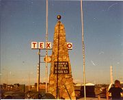
In 1931, the town of Rugby erected a 15 feet (4.6 m) tall rock obelisk
marking the "Geographical Center of North America". This was moved to a slightly different location in or after 1971. According to a listing by the U.S. Geological Survey, Rugby is actually approximately 15 miles (24.1 km) from the geographic center of North America
[6 miles (9.7 km)] west of Balta
), and even this designation carries no official status.
 Rugby is located at 48°22′2"N 99°59′46"W (48.367129, -99.995979). According to the United States Census Bureau
, the city has a total area of 1.9 mi2, all land. Rugby claims to be the geographic center of North America
and a monument stands in the city to signify this. The monument features flags of the United States, Canada
, and Mexico
.
of 2000, there were 2,939 people, 1,291 households, and 765 families residing in the city. The population density
was 1520.1 PD/sqmi. There were 1,434 housing units at an average density of 741.7 /sqmi. The racial makeup of the city was 98.09% White, 1.02% Native American, 0.37% Asian, 0.03% from other races
, and 0.48% from two or more races. Hispanic or Latino of any race were 0.44% of the population.
The top 6 ancestry groups in the city are German
(49.6%), Norwegian
(40.5%), Irish
(5.3%), English
(4.0%), Russia
n (3.7%), French
(3.6%).
There were 1,291 households out of which 26.6% had children under the age of 18 living with them, 49.0% were married couples
living together, 8.0% had a female householder with no husband present, and 40.7% were non-families. 37.3% of all households were made up of individuals and 21.2% had someone living alone who was 65 years of age or older. The average household size was 2.17 and the average family size was 2.89.
In the city the population was spread out with 23.1% under the age of 18, 5.4% from 18 to 24, 23.1% from 25 to 44, 20.2% from 45 to 64, and 28.1% who were 65 years of age or older. The median age was 44 years. For every 100 females there were 86.8 males. For every 100 females age 18 and over, there were 81.3 males.
The median income for a household in the city was $25,482, and the median income for a family was $35,745. Males had a median income of $25,885 versus $18,510 for females. The per capita income
for the city was $14,380. About 9.6% of families and 13.7% of the population were below the poverty line, including 11.6% of those under age 18 and 19.1% of those age 65 or over.
. Little Flower Catholic School is also in Rugby.
Pierce County, North Dakota
-National protected area:*Buffalo Lake National Wildlife Refuge-Demographics:As of the census of 2000, there were 4,675 people, 1,964 households, and 1,276 families residing in the county. The population density was 5 people per square mile . There were 2,269 housing units at an average density...
, North Dakota
North Dakota
North Dakota is a state located in the Midwestern region of the United States of America, along the Canadian border. The state is bordered by Canada to the north, Minnesota to the east, South Dakota to the south and Montana to the west. North Dakota is the 19th-largest state by area in the U.S....
in the United States. It is the county seat
County seat
A county seat is an administrative center, or seat of government, for a county or civil parish. The term is primarily used in the United States....
of Pierce County. The population was 2,876 at the 2010 census. Rugby was founded in 1886.
Rugby is often billed as being the geographic center of North America
North America
North America is a continent wholly within the Northern Hemisphere and almost wholly within the Western Hemisphere. It is also considered a northern subcontinent of the Americas...
.
History
Rugby was founded in 1886 at a junction on the Great Northern Railway, where a branch lineBranch line
A branch line is a secondary railway line which branches off a more important through route, usually a main line. A very short branch line may be called a spur line...
to Bottineau
Bottineau, North Dakota
As of the census of 2000, there were 2,336 people, 979 households, and 550 families residing in the city. The population density was 2,230.0 people per square mile . There were 1,114 housing units at an average density of 1,063.4 per square mile...
met the main line. The railroad promoters initially platted the town as Rugby Junction, getting the name Rugby from the town of Rugby
Rugby, Warwickshire
Rugby is a market town in Warwickshire, England, located on the River Avon. The town has a population of 61,988 making it the second largest town in the county...
in Warwickshire
Warwickshire
Warwickshire is a landlocked non-metropolitan county in the West Midlands region of England. The county town is Warwick, although the largest town is Nuneaton. The county is famous for being the birthplace of William Shakespeare...
, England. It was one of several sites along the Great Northern's transcontinental route
Transcontinental railroad
A transcontinental railroad is a contiguous network of railroad trackage that crosses a continental land mass with terminals at different oceans or continental borders. Such networks can be via the tracks of either a single railroad, or over those owned or controlled by multiple railway companies...
between Devils Lake
Devils Lake, North Dakota
As of the 2000 Census, there were 7,222 people, 3,127 households, and 1,773 families residing in the city. The population density was . There were 3,508 housing units at an average density of . The racial makeup of the city was 89.23% White, 0.22% African American, 7.84% Native American, 0.28%...
and Minot
Minot, North Dakota
Minot is a city located in north central North Dakota in the United States. It is most widely known for the Air Force base located approximately 15 miles north of the city. With a population of 40,888 at the 2010 census, Minot is the fourth largest city in the state...
that were named after places in England (the others were Berwick, Leeds
Leeds, North Dakota
As of the census of 2000, there were 464 people, 212 households, and 129 families residing in the city. The population density was 1,018.8 people per square mile . There were 282 housing units at an average density of 619.2 per square mile...
, Norwich
Norwich, North Dakota
Norwich is an unincorporated community in western McHenry County, North Dakota, United States. It lies along U.S. Route 2 southwest of the city of Towner, the county seat of McHenry County. Its elevation is 1,549 feet . It is unincorporated, and had a post office with the ZIP code of 58768...
, Penn
Penn, North Dakota
Penn is an unincorporated community in western Ramsey County, North Dakota, United States. It lies along U.S. Route 2 northwest of the city of Devils Lake, the county seat of Ramsey County. Its elevation is 1,467 feet . The community was first named Lauren for the townsite owner, Lauren,...
, Surrey
Surrey, North Dakota
As of the census of 2000, there were 917 people, 307 households, and 260 families residing in the city. The population density was 943.1 people per square mile . There were 313 housing units at an average density of 321.9 per square mile . The racial makeup of the city was 97.27% White, 1.85%...
, Tunbridge, and York
York, North Dakota
As of the census of 2000, there were 26 people, 11 households, and 7 families residing in the city. The population density was 114.1 people per square mile . There were 32 housing units at an average density of 140.4 per square mile...
). When the community became a city, the Junction was dropped from the name.
North Dakota's first permanent European settlers arrived in 1812 from the Earl of Selkirk’s
Thomas Douglas, 5th Earl of Selkirk
Thomas Douglas, 5th Earl of Selkirk was a Scottish peer. He was born at Saint Mary's Isle, Kirkcudbrightshire, Scotland. He was noteworthy as a Scottish philanthropist who sponsored immigrant settlements in Canada at the Red River Colony.- Early background :Douglas was the seventh son of Dunbar...
colony in neighboring Manitoba
Manitoba
Manitoba is a Canadian prairie province with an area of . The province has over 110,000 lakes and has a largely continental climate because of its flat topography. Agriculture, mostly concentrated in the fertile southern and western parts of the province, is vital to the province's economy; other...
, Canada
Canada
Canada is a North American country consisting of ten provinces and three territories. Located in the northern part of the continent, it extends from the Atlantic Ocean in the east to the Pacific Ocean in the west, and northward into the Arctic Ocean...
. As farmers, they were more advanced than many of their contemporaries in the rest of the United States, having adopted sophisticated farming methods and machinery. Many of these implements, including an early McCormick Deering threshing machine
Threshing machine
The thrashing machine, or, in modern spelling, threshing machine , was a machine first invented by Scottish mechanical engineer Andrew Meikle for use in agriculture. It was invented for the separation of grain from stalks and husks. For thousands of years, grain was separated by hand with flails,...
, have found their way to the restored Pioneer Village in Rugby.
In 1931, the town of Rugby erected a 15 feet (4.6 m) tall rock obelisk
Obelisk
An obelisk is a tall, four-sided, narrow tapering monument which ends in a pyramid-like shape at the top, and is said to resemble a petrified ray of the sun-disk. A pair of obelisks usually stood in front of a pylon...
marking the "Geographical Center of North America". This was moved to a slightly different location in or after 1971. According to a listing by the U.S. Geological Survey, Rugby is actually approximately 15 miles (24.1 km) from the geographic center of North America
North America
North America is a continent wholly within the Northern Hemisphere and almost wholly within the Western Hemisphere. It is also considered a northern subcontinent of the Americas...
[6 miles (9.7 km)] west of Balta
Balta, North Dakota
As of the census of 2000, there were 73 people, 38 households, and 21 families residing in the city. The population density was 327.1 people per square mile . There were 49 housing units at an average density of 219.6/sq mi...
), and even this designation carries no official status.
Geography
United States Census Bureau
The United States Census Bureau is the government agency that is responsible for the United States Census. It also gathers other national demographic and economic data...
, the city has a total area of 1.9 mi2, all land. Rugby claims to be the geographic center of North America
North America
North America is a continent wholly within the Northern Hemisphere and almost wholly within the Western Hemisphere. It is also considered a northern subcontinent of the Americas...
and a monument stands in the city to signify this. The monument features flags of the United States, Canada
Canada
Canada is a North American country consisting of ten provinces and three territories. Located in the northern part of the continent, it extends from the Atlantic Ocean in the east to the Pacific Ocean in the west, and northward into the Arctic Ocean...
, and Mexico
Mexico
The United Mexican States , commonly known as Mexico , is a federal constitutional republic in North America. It is bordered on the north by the United States; on the south and west by the Pacific Ocean; on the southeast by Guatemala, Belize, and the Caribbean Sea; and on the east by the Gulf of...
.
Demographics
As of the censusCensus
A census is the procedure of systematically acquiring and recording information about the members of a given population. It is a regularly occurring and official count of a particular population. The term is used mostly in connection with national population and housing censuses; other common...
of 2000, there were 2,939 people, 1,291 households, and 765 families residing in the city. The population density
Population density
Population density is a measurement of population per unit area or unit volume. It is frequently applied to living organisms, and particularly to humans...
was 1520.1 PD/sqmi. There were 1,434 housing units at an average density of 741.7 /sqmi. The racial makeup of the city was 98.09% White, 1.02% Native American, 0.37% Asian, 0.03% from other races
Race (United States Census)
Race and ethnicity in the United States Census, as defined by the Federal Office of Management and Budget and the United States Census Bureau, are self-identification data items in which residents choose the race or races with which they most closely identify, and indicate whether or not they are...
, and 0.48% from two or more races. Hispanic or Latino of any race were 0.44% of the population.
The top 6 ancestry groups in the city are German
Germany
Germany , officially the Federal Republic of Germany , is a federal parliamentary republic in Europe. The country consists of 16 states while the capital and largest city is Berlin. Germany covers an area of 357,021 km2 and has a largely temperate seasonal climate...
(49.6%), Norwegian
Norway
Norway , officially the Kingdom of Norway, is a Nordic unitary constitutional monarchy whose territory comprises the western portion of the Scandinavian Peninsula, Jan Mayen, and the Arctic archipelago of Svalbard and Bouvet Island. Norway has a total area of and a population of about 4.9 million...
(40.5%), Irish
Ireland
Ireland is an island to the northwest of continental Europe. It is the third-largest island in Europe and the twentieth-largest island on Earth...
(5.3%), English
England
England is a country that is part of the United Kingdom. It shares land borders with Scotland to the north and Wales to the west; the Irish Sea is to the north west, the Celtic Sea to the south west, with the North Sea to the east and the English Channel to the south separating it from continental...
(4.0%), Russia
Russia
Russia or , officially known as both Russia and the Russian Federation , is a country in northern Eurasia. It is a federal semi-presidential republic, comprising 83 federal subjects...
n (3.7%), French
France
The French Republic , The French Republic , The French Republic , (commonly known as France , is a unitary semi-presidential republic in Western Europe with several overseas territories and islands located on other continents and in the Indian, Pacific, and Atlantic oceans. Metropolitan France...
(3.6%).
There were 1,291 households out of which 26.6% had children under the age of 18 living with them, 49.0% were married couples
Marriage
Marriage is a social union or legal contract between people that creates kinship. It is an institution in which interpersonal relationships, usually intimate and sexual, are acknowledged in a variety of ways, depending on the culture or subculture in which it is found...
living together, 8.0% had a female householder with no husband present, and 40.7% were non-families. 37.3% of all households were made up of individuals and 21.2% had someone living alone who was 65 years of age or older. The average household size was 2.17 and the average family size was 2.89.
In the city the population was spread out with 23.1% under the age of 18, 5.4% from 18 to 24, 23.1% from 25 to 44, 20.2% from 45 to 64, and 28.1% who were 65 years of age or older. The median age was 44 years. For every 100 females there were 86.8 males. For every 100 females age 18 and over, there were 81.3 males.
The median income for a household in the city was $25,482, and the median income for a family was $35,745. Males had a median income of $25,885 versus $18,510 for females. The per capita income
Per capita income
Per capita income or income per person is a measure of mean income within an economic aggregate, such as a country or city. It is calculated by taking a measure of all sources of income in the aggregate and dividing it by the total population...
for the city was $14,380. About 9.6% of families and 13.7% of the population were below the poverty line, including 11.6% of those under age 18 and 19.1% of those age 65 or over.
Notable people
- Todd Brandt, radio personality with The Todd and Tyler Radio Empire.
- Larry WatsonLarry WatsonLarry Watson is an American author of novels, poetry and short stories. He was born in 1947 in Rugby, North Dakota. He grew up in Bismarck, North Dakota. He earned both Bachelors and Masters degrees in fine arts at the University of North Dakota...
, poet, writer, and educator.
Education
The city of Rugby is served by Ely Elementary School and Rugby High SchoolRugby High School
Rugby High School is a public high school located on Rugby, North Dakota. The athletic teams are known as the "The Panthers".-Championships:*State Class 'B' boys basketball: 1940, 1941*State Class 'A' boys basketball: 1962...
. Little Flower Catholic School is also in Rugby.
Sites of interest
- Geographical Center of North America - Rugby is located in the geographical center of North America. There is a cairnCairnCairn is a term used mainly in the English-speaking world for a man-made pile of stones. It comes from the or . Cairns are found all over the world in uplands, on moorland, on mountaintops, near waterways and on sea cliffs, and also in barren desert and tundra areas...
marking this spot. - Prairie Village Museum houses some of Pierce County's oldest historical buildings & artifacts including the 1886 Great Northern Railroad Depot.
- The Victorian Dress Museum -The building that houses the museum is listed in the National Register of Historic PlacesNational Register of Historic PlacesThe National Register of Historic Places is the United States government's official list of districts, sites, buildings, structures, and objects deemed worthy of preservation...
.
External links
- City of Rugby official website
- Cairn marking Center of North America
- State of North Dakota website discussing Rugby's status as Geographic Center of North America
- The Pierce County Tribune