
.gif)
Route 10 (New England)
Encyclopedia
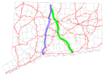
New England Route 10 was a multi-state north–south state highway
in the New England
region of the United States
, running through Connecticut
, Massachusetts
, and New Hampshire
. "Route 10" still exists as a continuous state highway in each of its original states, running from New Haven, Connecticut
to Woodsville, New Hampshire
. Its number dates from 1922, when it was a New England Interstate Route, also known as the Central New England Route.
Route 10 is often called the College Highway because it links Yale University
, Trinity College
, Mount Holyoke College
, Smith College
, Amherst College
, the University of Massachusetts and Dartmouth College
. Yale and Dartmouth are in the Ivy League
and Smith and Mount Holyoke are in the Seven Sisters
group of exclusive women's colleges.
 Route 10 originally followed a different route south of Granby, Connecticut
, starting in the town of Old Saybrook
instead of at its current New Haven terminus. It moved to its current alignment along the Connecticut section of the College Highway in 1932, with the former alignment becoming the original Route 9
. The original routing is now Routes 154, 99, and 189.
New England Route 10 also originally ended in Littleton, New Hampshire
(at Route 18) but was subsequently truncated to end at its current northern terminus in Woodsville
. The rest of the route has had only very minor changes and basically still follows its successor highways in the three states.
. Route 10 continued north through the towns of Hamden
, Cheshire
, Southington
, Plainville
, Farmington
, Avon
, and Simsbury
.
. It ran north through the Pioneer Valley
towns of Southwick, Westfield
, Southampton
, Easthampton
, Northampton
, Hatfield
, Whately
, Deerfield
, Greenfield
, Bernardston
, Gill
, and Northfield
. It crossed the Connecticut River
in Northfield before entering New Hampshire.
. The road continued into Keene
. From Keene, NH 10 travels north via Newport
until Grantham
. NH 10 then traveled along the east bank of the Connecticut River
from Lebanon up to Woodsville
. Signage for Route 10 continued all the way to Littleton.
State highway
State highway, state road or state route can refer to one of three related concepts, two of them related to a state or provincial government in a country that is divided into states or provinces :#A...
in the New England
New England
New England is a region in the northeastern corner of the United States consisting of the six states of Maine, New Hampshire, Vermont, Massachusetts, Rhode Island, and Connecticut...
region of the United States
United States
The United States of America is a federal constitutional republic comprising fifty states and a federal district...
, running through Connecticut
Connecticut
Connecticut is a state in the New England region of the northeastern United States. It is bordered by Rhode Island to the east, Massachusetts to the north, and the state of New York to the west and the south .Connecticut is named for the Connecticut River, the major U.S. river that approximately...
, Massachusetts
Massachusetts
The Commonwealth of Massachusetts is a state in the New England region of the northeastern United States of America. It is bordered by Rhode Island and Connecticut to the south, New York to the west, and Vermont and New Hampshire to the north; at its east lies the Atlantic Ocean. As of the 2010...
, and New Hampshire
New Hampshire
New Hampshire is a state in the New England region of the northeastern United States of America. The state was named after the southern English county of Hampshire. It is bordered by Massachusetts to the south, Vermont to the west, Maine and the Atlantic Ocean to the east, and the Canadian...
. "Route 10" still exists as a continuous state highway in each of its original states, running from New Haven, Connecticut
New Haven, Connecticut
New Haven is the second-largest city in Connecticut and the sixth-largest in New England. According to the 2010 Census, New Haven's population increased by 5.0% between 2000 and 2010, a rate higher than that of the State of Connecticut, and higher than that of the state's five largest cities, and...
to Woodsville, New Hampshire
Woodsville, New Hampshire
Woodsville is a census-designated place in the town of Haverhill in Grafton County, New Hampshire, U.S., along the Connecticut River at the mouth of the Ammonoosuc River. The population was 1,126 at the 2010 census...
. Its number dates from 1922, when it was a New England Interstate Route, also known as the Central New England Route.
Route 10 is often called the College Highway because it links Yale University
Yale University
Yale University is a private, Ivy League university located in New Haven, Connecticut, United States. Founded in 1701 in the Colony of Connecticut, the university is the third-oldest institution of higher education in the United States...
, Trinity College
Trinity College (Connecticut)
Trinity College is a private, liberal arts college in Hartford, Connecticut. Founded in 1823, it is the second-oldest college in the state of Connecticut after Yale University. The college enrolls 2,300 students and has been coeducational since 1969. Trinity offers 38 majors and 26 minors, and has...
, Mount Holyoke College
Mount Holyoke College
Mount Holyoke College is a liberal arts college for women in South Hadley, Massachusetts. It was the first member of the Seven Sisters colleges, and served as a model for some of the others...
, Smith College
Smith College
Smith College is a private, independent women's liberal arts college located in Northampton, Massachusetts. It is the largest member of the Seven Sisters...
, Amherst College
Amherst College
Amherst College is a private liberal arts college located in Amherst, Massachusetts, United States. Amherst is an exclusively undergraduate four-year institution and enrolled 1,744 students in the fall of 2009...
, the University of Massachusetts and Dartmouth College
Dartmouth College
Dartmouth College is a private, Ivy League university in Hanover, New Hampshire, United States. The institution comprises a liberal arts college, Dartmouth Medical School, Thayer School of Engineering, and the Tuck School of Business, as well as 19 graduate programs in the arts and sciences...
. Yale and Dartmouth are in the Ivy League
Ivy League
The Ivy League is an athletic conference comprising eight private institutions of higher education in the Northeastern United States. The conference name is also commonly used to refer to those eight schools as a group...
and Smith and Mount Holyoke are in the Seven Sisters
Seven Sisters (colleges)
The Seven Sisters are seven liberal arts colleges in the Northeastern United States that are historically women's colleges. They are Barnard College, Bryn Mawr College, Mount Holyoke College, Radcliffe College, Smith College, Vassar College, and Wellesley College. All were founded between 1837 and...
group of exclusive women's colleges.
History
Granby, Connecticut
Granby is a town in Hartford County, Connecticut, United States. The population was 10,347 at the 2000 census. The town center was defined as a census-designated place known as Salmon Brook in the 2000 census....
, starting in the town of Old Saybrook
Old Saybrook, Connecticut
Old Saybrook is a town in Middlesex County, Connecticut, United States. The population was 10,367 at the 2000 census. It contains the incorporated borough of Fenwick, as well as the census-designated places of Old Saybrook Center and Saybrook Manor.-History:...
instead of at its current New Haven terminus. It moved to its current alignment along the Connecticut section of the College Highway in 1932, with the former alignment becoming the original Route 9
Route 9 (Connecticut)
Route 9 is a , 4-lane freeway beginning in Old Saybrook and ending at the Farmington-West Hartford town line.-Route description:Route 9 begins at an interchange with I-95/U.S. 1, on the west banks of the Connecticut River...
. The original routing is now Routes 154, 99, and 189.
New England Route 10 also originally ended in Littleton, New Hampshire
Littleton, New Hampshire
Littleton is a town in Grafton County, New Hampshire, United States. The population was 5,928 at the 2010 census. Situated at the edge of the White Mountains, Littleton is bounded on the northwest by the Connecticut River....
(at Route 18) but was subsequently truncated to end at its current northern terminus in Woodsville
Woodsville, New Hampshire
Woodsville is a census-designated place in the town of Haverhill in Grafton County, New Hampshire, U.S., along the Connecticut River at the mouth of the Ammonoosuc River. The population was 1,126 at the 2010 census...
. The rest of the route has had only very minor changes and basically still follows its successor highways in the three states.
Connecticut
Route 10 in Connecticut began in the city of New HavenNew Haven, Connecticut
New Haven is the second-largest city in Connecticut and the sixth-largest in New England. According to the 2010 Census, New Haven's population increased by 5.0% between 2000 and 2010, a rate higher than that of the State of Connecticut, and higher than that of the state's five largest cities, and...
. Route 10 continued north through the towns of Hamden
Hamden, Connecticut
Hamden is a town in New Haven County, Connecticut, United States. The town's nickname is "The Land of the Sleeping Giant." Hamden is home to Quinnipiac University. The population was 58,180 according to the Census Bureau's 2005 estimates...
, Cheshire
Cheshire, Connecticut
Cheshire is a town in New Haven County, Connecticut, United States. The population was 28,543 at the 2000 census. The center of population of Connecticut is located in Cheshire. In 2009 Cheshire was ranked 72 in Money Magazine's 100 Best Places to Live.Likewise, in 2011 Cheshire was ranked 73 in...
, Southington
Southington, Connecticut
Southington is a town in Hartford County, Connecticut, United States. It is part of Connecticut's 1st congressional district. It is situated about 20 miles southwest of Hartford, about 80 miles northeast of New York City, 105 miles southwest of Boston and 77 miles west of Providence...
, Plainville
Plainville, Connecticut
Plainville is a town in Hartford County, Connecticut, United States. The population was 17,328 at the 2000 census.-Geography:According to the United States Census Bureau, the town has a total area of 9.8 square miles , of which 9.8 square miles is land and 0.1 square miles is water...
, Farmington
Farmington, Connecticut
Farmington is a town located in Hartford County in the Farmington Valley area of central Connecticut in the United States. The population was 25,340 at the 2010 census. It is home to the world headquarters of several large corporations including Carrier Corporation, Otis Elevator Company, and Carvel...
, Avon
Avon, Connecticut
Avon is a town in the Farmington Valley region of Hartford County, Connecticut, United States. , the town had a population of 18,098.Avon is a suburb of Hartford. Avon Old Farms School, a prestigious boarding school, is located there. In 2005, Avon was named the third-safest town in America by...
, and Simsbury
Simsbury, Connecticut
Simsbury is a suburban town in Hartford County, Connecticut, United States. The population was 23,234 at the 2000 census. The town was incorporated as Connecticut's twenty-first town in May 1670.-Early history:...
.
Massachusetts
Route 10 in Massachusetts crossed the border from Granby, Connecticut into Southwick, MassachusettsSouthwick, Massachusetts
Southwick is a town in Hampden County, Massachusetts, United States. The population was 9,502 at the 2010 census. It is part of the Springfield, Massachusetts Metropolitan Statistical Area.- History :...
. It ran north through the Pioneer Valley
Pioneer Valley
The Pioneer Valley is the colloquial name for the U.S. Commonwealth of Massachusetts's portion of the Connecticut River Valley. The Pioneer Valley consists of three counties in Massachusetts which collectively feature much of New England's most fertile farmland...
towns of Southwick, Westfield
Westfield, Massachusetts
Westfield is a city in Hampden County, in the Pioneer Valley of western Massachusetts, United States. It is part of the Springfield, Massachusetts Metropolitan Statistical Area. The population was 41,094 at the 2010 census. The ZIP Code is 01085 for homes and businesses, 01086 for Westfield State...
, Southampton
Southampton, Massachusetts
Southampton is a town in Hampshire County, Massachusetts, United States. It was established first as a district of Northampton in 1753. It was incorporated in 1753. The name Southampton was given to it during its first town meeting in 1773. Its ZIP code is 01073...
, Easthampton
Easthampton, Massachusetts
Easthampton is the second largest city in Hampshire County, Massachusetts, United States. The town is on the southeastern edge of an area called the Pioneer Valley near the five colleges in the college towns of Northampton and Amherst, MA...
, Northampton
Northampton, Massachusetts
The city of Northampton is the county seat of Hampshire County, Massachusetts, United States. As of the 2010 census, the population of Northampton's central neighborhoods, was 28,549...
, Hatfield
Hatfield, Massachusetts
Hatfield is a town in Hampshire County, Massachusetts, United States. The population was 3,249 at the 2000 census. It is part of the Springfield, Massachusetts Metropolitan Statistical Area....
, Whately
Whately, Massachusetts
Whately is a town in Franklin County, Massachusetts, United States. The population was 1,573 at the 2000 census. It is part of the Springfield, Massachusetts Metropolitan Statistical Area.- History :...
, Deerfield
Deerfield, Massachusetts
Deerfield is a town in Franklin County, Massachusetts, United States. The population was 4,750 as of the 2000 census. Deerfield is part of the Springfield, Massachusetts Metropolitan Statistical Area in Western Massachusetts, lying only north of the city of Springfield.Deerfield includes the...
, Greenfield
Greenfield, Massachusetts
Greenfield is a city in Franklin County, Massachusetts, United States. The population was 17,456 at the 2010 census. It is the county seat of Franklin County. Greenfield is home to Greenfield Community College, the Pioneer Valley Symphony Orchestra, and the Franklin County Fair...
, Bernardston
Bernardston, Massachusetts
Bernardston is a town in Franklin County, Massachusetts, United States. The population was 2,155 at the 2000 census. It is part of the Springfield, Massachusetts Metropolitan Statistical Area.- History :...
, Gill
Gill, Massachusetts
Gill is a town in Franklin County, Massachusetts, USA. The population was 1,363 at the 2000 census. It is part of the Springfield, Massachusetts Metropolitan Statistical Area...
, and Northfield
Northfield, Massachusetts
Northfield is a town in Franklin County, Massachusetts, United States. The population was 2,951 at the 2000 census. It is part of the Springfield, Massachusetts Metropolitan Statistical Area...
. It crossed the Connecticut River
Connecticut River
The Connecticut River is the largest and longest river in New England, and also an American Heritage River. It flows roughly south, starting from the Fourth Connecticut Lake in New Hampshire. After flowing through the remaining Connecticut Lakes and Lake Francis, it defines the border between the...
in Northfield before entering New Hampshire.
New Hampshire
Route 10 in New Hampshire began at the Massachusetts state line in Winchester, New HampshireWinchester, New Hampshire
Winchester is a town in Cheshire County, New Hampshire, United States. The population was 4,341 at the 2010 census. The primary settlement in the town, where 1,733 people resided at the 2010 census, is defined by the U.S. Census Bureau as the Winchester census-designated place...
. The road continued into Keene
Keene, New Hampshire
Keene is a city in Cheshire County, New Hampshire, United States. The population was 23,409 at the 2010 census. It is the county seat of Cheshire County.Keene is home to Keene State College and Antioch University New England, and hosts the annual Pumpkin Fest...
. From Keene, NH 10 travels north via Newport
Newport, New Hampshire
Newport is a town in and the county seat of Sullivan County, New Hampshire, United States. It is west-northwest of Concord. The population was 6,507 at the 2010 census. A covered bridge is in the northwest...
until Grantham
Grantham, New Hampshire
Grantham is a town in Sullivan County, New Hampshire, United States. The population was 2,985 at the 2010 census. This made Grantham the fastest growing town numerically in Sullivan County between the 2000 and 2010 censuses...
. NH 10 then traveled along the east bank of the Connecticut River
Connecticut River
The Connecticut River is the largest and longest river in New England, and also an American Heritage River. It flows roughly south, starting from the Fourth Connecticut Lake in New Hampshire. After flowing through the remaining Connecticut Lakes and Lake Francis, it defines the border between the...
from Lebanon up to Woodsville
Woodsville, New Hampshire
Woodsville is a census-designated place in the town of Haverhill in Grafton County, New Hampshire, U.S., along the Connecticut River at the mouth of the Ammonoosuc River. The population was 1,126 at the 2010 census...
. Signage for Route 10 continued all the way to Littleton.