

Rossøya
Encyclopedia
Barents Sea
The Barents Sea is a marginal sea of the Arctic Ocean, located north of Norway and Russia. Known in the Middle Ages as the Murman Sea, the sea takes its current name from the Dutch navigator Willem Barents...
. It is a part of Sjuøyane
Sjuøyane
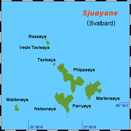
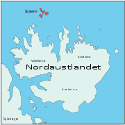
Sjuøyane is the northernmost part of the Svalbard archipelago, just north of Nordaustlandet. As the name implies, this is a group of seven islands , although three are mere islets. The principal islands are Phippsøya, Parryøya, Martensøya, Nelsonøya and Waldenøya, the islets are Tavleøya, Vesle...
, a group of islands in the Svalbard
Svalbard
Svalbard is an archipelago in the Arctic, constituting the northernmost part of Norway. It is located north of mainland Europe, midway between mainland Norway and the North Pole. The group of islands range from 74° to 81° north latitude , and from 10° to 35° east longitude. Spitsbergen is the...
archipelago, just north of the coast of Nordaustlandet
Nordaustlandet
Nordaustlandet is the second-largest island in the archipelago of Svalbard, Norway, with an area of . It lies north east of Spitsbergen, separated by Hinlopenstretet. Much of Nordaustlandet lies under large ice caps, mainly Austfonna and Vestfonna, the remaining parts of the north being tundra...
. Rossøya is located just north-west of the slightly larger island Vesle Tavleøya
Vesle Tavleøya
Vesle Tavleøya is the largest island of the two northernmost of Sjuøyane, north of Nordaustlandet.-References:* Norwegian Polar Institute...
. The northern point of Rossøya, at 80° 49′ 44.41″ North, is the northern-most point in Svalbard, and thereby also in the Kingdom of Norway
Norway
Norway , officially the Kingdom of Norway, is a Nordic unitary constitutional monarchy whose territory comprises the western portion of the Scandinavian Peninsula, Jan Mayen, and the Arctic archipelago of Svalbard and Bouvet Island. Norway has a total area of and a population of about 4.9 million...
. Some sources describe Rossøya as the northernmost point of Europe, but this requires that Franz Josef Land
Franz Josef Land
Franz Josef Land, Franz Joseph Land, or Francis Joseph's Land is an archipelago located in the far north of Russia. It is found in the Arctic Ocean north of Novaya Zemlya and east of Svalbard, and is administered by Arkhangelsk Oblast. Franz Josef Land consists of 191 ice-covered islands with a...
be considered part of Asia, since Cape Fligely on Rudolf Island
Rudolf Island
Prince Rudolf Land, Crown Prince Rudolf Land, Prince Rudolf Island or Rudolf Island is the northernmost island of the Franz Josef Archipelago, Russia. The island was named by the Austro-Hungarian North Pole Expedition in honor of Archduke Rudolf , Crown Prince of Austria, Hungary and Bohemia...
, Russia
Russia
Russia or , officially known as both Russia and the Russian Federation , is a country in northern Eurasia. It is a federal semi-presidential republic, comprising 83 federal subjects...
, is located at 81° 48′ 24″ North.
The island is named after James Clark Ross
James Clark Ross
Sir James Clark Ross , was a British naval officer and explorer. He explored the Arctic with his uncle Sir John Ross and Sir William Parry, and later led his own expedition to Antarctica.-Arctic explorer:...
(1800–1862), a British
United Kingdom
The United Kingdom of Great Britain and Northern IrelandIn the United Kingdom and Dependencies, other languages have been officially recognised as legitimate autochthonous languages under the European Charter for Regional or Minority Languages...
explorer who was part of William Edward Parry
William Edward Parry
Sir William Edward Parry was an English rear-admiral and Arctic explorer, who in 1827 attempted one of the earliest expeditions to the North Pole...
's 1827 expedition with HMS Hecla
HMS Hecla (1815)
HMS Hecla was a Royal Navy Hecla-class bomb vessel of 372 tons. Launched on 15 July 1815, she saw wartime service in an attack on Barbary pirates at Algiers in August, 1816...
to reach the North Pole
North Pole
The North Pole, also known as the Geographic North Pole or Terrestrial North Pole, is, subject to the caveats explained below, defined as the point in the northern hemisphere where the Earth's axis of rotation meets its surface...
. After passing by Sjuøyane and Rossøya, the expedition was forced to give up, after getting stuck in the ice. However, the expedition set a new record as the expedition that had reached the furthest north at the time. The island may have been sighted as early as 1618, along with the rest of Sjuøyane, by an Enkhuizen whaler. However, the island was marked on a map as early as 1663 by Hendrick Doncker. This was later followed by cartographers such as Pieter Goos, Cornelis Giles and Outger Rep. The distance to the North Pole
North Pole
The North Pole, also known as the Geographic North Pole or Terrestrial North Pole, is, subject to the caveats explained below, defined as the point in the northern hemisphere where the Earth's axis of rotation meets its surface...
is 1024.3 kilometers (637 mi / 553 nm), about 350 kilometres (217.5 mi) from Longyearbyen
Longyearbyen
Longyearbyen is the largest settlement and the administrative centre of Svalbard, Norway. It is located on the western coast of Spitsbergen, the largest island of the Svalbard archipelago, on the southern side on Adventfjorden , which continues inland with Adventdalen...
and about 50 kilometres (31.1 mi) from Nordaustlandet. The island has been part of the Northeast Svalbard Nature Reserve since 1 January 1973.
Accessibility by ship can be difficult due to ice conditions, but the island is more affected by the Gulf Stream
Gulf Stream
The Gulf Stream, together with its northern extension towards Europe, the North Atlantic Drift, is a powerful, warm, and swift Atlantic ocean current that originates at the tip of Florida, and follows the eastern coastlines of the United States and Newfoundland before crossing the Atlantic Ocean...
than more southeasterly parts of Svalbard. The island is slightly greenish, due to the plant Cochleraria groenlandica, that thrives due to the natural fertilizing from the birds' excrements. The most common bird is the Little Auk
Little Auk
The Little Auk, or Dovekie , is a small auk, the only member of the genus Alle. It breeds on islands in the high Arctic. There are two subspecies: A. a. alle breeds in Greenland, Iceland, Novaya Zemlya and Spitsbergen, and A. a...
, though other common species include the Atlantic Puffin
Atlantic Puffin
The Atlantic Puffin is a seabird species in the auk family. It is a pelagic bird that feeds primarily by diving for fish, but also eats other sea creatures, such as squid and crustaceans. Its most obvious characteristic during the breeding season is its brightly coloured bill...
and Brünnich's Guillemot
Brünnich's Guillemot
The Thick-billed Murre or Brünnich's Guillemot is a bird in the auk family . This bird is named after the Danish zoologist Morten Thrane Brünnich...
. Birds arrive in April–May, and stay during the summer. The only mammal is the polar bear
Polar Bear
The polar bear is a bear native largely within the Arctic Circle encompassing the Arctic Ocean, its surrounding seas and surrounding land masses. It is the world's largest land carnivore and also the largest bear, together with the omnivorous Kodiak Bear, which is approximately the same size...
, which is most commonly found during the winter, when it can use the ice to cross to the island.