
Rosendale, New York
Encyclopedia
Rosendale is a town
in the center of Ulster County
, New York
, United States
. It once contained a village of the same name, which was dissolved through a vote. The population was 6,075 at the 2010 census.
, Marbletown
, and New Paltz.
According to the History of Rosendale, NY, by Hamilton Child, Syracuse, NY 1871:
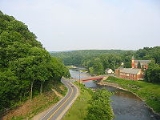
ROSENDALE was formed from Marbletown, New Paltz and Hurley, April 26, 1844. It is an interior town, lying east of the center of the County. The surface is a rolling and broken upland, the highest summits being from 200 to 500 feet (152.4 m) above the valleys. Rondout Creek flows north-east through the town near the center, receiving Coxingkill from the south, and Cottlekill from the north. The Delaware and Hudson Canal extends along the Rondout Creek. The soil is chiefly a sandy loam. In the north-west part of the town are several small lakes, called the Binnewaters. Cement is extensively manufactured throughout the town. The Wallkill Valley R.R. extends through the whole length of the town. In the south-west part are three caves, in a ledge of rocks of the Shawangunk Mountains, where ice is found at all times of the year.
Rosendale. (p.v.) situated on the creek and canal, near the center of the town, contains three churches, viz., Reformed, Baptist and Roman Catholic; two hotels, two stores, a school, two blacksmith shops, three wagon shoes, an undertaker, coal yard, a harness shop, a shoe shop, two milliners, a meat market, a cement kiln and about 550 inhabitants. The W.V. R.R. crosses the creek at this place on a bridge 900 feet (274.3 m) long and 140 feet (42.7 m) above the water.
 Lawrenceville, names in honor of Mr. Watson E. Lawrence, is situated on the creek, about a mile above Rosendale, and contains two cement manufactories and about 400 inhabitants.
The Rosendale Cement Company's Mills at this place, have a capacity for manufacturing about 350 barrels daily, and give employment to about 60 men. This is the pioneer company in the manufacture of cement, and was established by Mr. Watson E. Lawrence, who now resides in New York.
Lawrenceville Cement Co. have a capacity for manufacturing about 125,000 barrels each season, giving employment to about 130 men. The mills are on the Delaware and Hudson Canal.
Bruceville, in the west part of the town, on Rondout Creek, about two and a half miles from Rosendale, contains a store, a cement mill and fifteen dwellings.
The Bruceville Cement Manufactory makes about 30,000 barrels each season, and gives employment to about 35 hands. The mills have a capacity for about 300 barrels per day. James H. Van Demark is the proprietor.
A mineral spring at this place receives some patronage.
Rosendale Plains is a hamlet about one and a fourth miles south of Rosendale, and contains a hotel, a blacksmith shop, a trotting course and ten dwellings.
LeFevre Falls, (p.v.) formerly known as Rook Lock, is situated about a mile below Rosendale, and contains a store, three hotels, two cement manufactories and about thirty dwellings.
The New York Cement Company, at this place, manufacture about 500 barrels of cement per day and about 100,000 barrels during the season.
Martin & Clearwater's Cement Works have a capacity for making 80,000 barrels per season, and give employment to about one hundred men.
Whiteport, in the north-east part of the town, is about four miles north from Rosendale, and about the same distance south-west of Rondout. It contains the Neward & Rosendale Lime and Cement Works and a population of about 1,500, including what is known as Hickory Bush. The village has been built up almost wholly by the Cement Works. They manufacture about 800 barrels per day, and have a capacity for 1,000 barrels. The barrels are all made here and their cement is transported to tide water over a horse railroad. They employ about 180 men. The quarries are entered by tunnels, two of which are 200 feet (61 m) in length each, and one seventy feet. They have a perpendicular depth of about 120 to 140 feet (42.7 m). They have seventeen kilns, fifteen of which are in constant use. It is ground in a mill containing twelve runs of three feet stones, the power being a fifty horse-power water wheel and two 100 horse-power engines.
 The Lawrence Cement Company was established in 1848. Their works are about a mile south of Whiteport. They manufacture about 550 barrels per day, and give employment to about 100 men. Their cement is quarried and burned here, and transported over a horse railroad to Eddyville, where it is ground and shipped.
Creek Locks, (p.v) in the east part of the town, where the canal locks into the creek, contains two stores, a grocery, a school and about 25 dwellings. The Hudson River Cement Works, located on the Hudson River, a few miles above Rondout, have an extensive quarry near Creek Locks, where they give employment to about fifty men. The stone is conveyed from the quarry about three-eights of a mile on an inclined plain railway, the descending cars drawing up the ascending ones.
The Warner Lime and Cement Co. of Troy, have a quarry and kilns in this town, where they give employment to fifteen men.
The first settlement of this town was made about 1700. It received its name from the old “Rosendale Farm” where an inn was kept in 1711. The place is now owned by Mrs. M.C. Cornell. It was the residence of Col. Rutzer, one of the patentees. The house is of stone and was for a long time the office of the Loan Commissioner of the County. General Washington visited the County in June 1783, when Mrs. Washington and Governor and Mrs. Clinton were entertained in this house by Col. Hardenburgh. As this town had no separate organization until 1844, its early history is blended with that of adjacent towns from which it was taken.
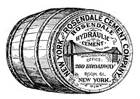
“Gordon's Gazetteer” published in 1836, says the village of Rosendale contains ten or twelve dwellings and a hydraulic cement factory, owned by W.E. Lawrence, and giving employment to from 100 to 200 hands, and producing 500 casks daily.
The Reformed Church was the first organized in the town. Rev. J. McFarland was the first pastor. Their house of worship was erected in 1843; it will seat 300 and cost $2,500. The present membership is 82. Rev. M.F. Libeneau is the pastor.
The New School Baptist Church was organized by Lewis Raymond with 26 members. The first pastor was David Mores. Their house of worship was erected in 1841; it will seat 350 and cost $1,600. Its present value is $3,500. The present membership is 70, and the pastor is Rev. D. Van Fredenburgh.
St. Peter's Roman Catholic Church was organized in 1851 by Father Martin; with about 50 members. The first services were held under a tree on the present site of the church. Their house of worship was erected in 1852; it seats 350. The first pastor was Rev. Edward Lynch; the present pastor is Rev. Patrick Brady. The membership is 1,500 and the value of the church property is about $10,000.
The population in 1870 was 3,625, and its area 11299 acres (45.7 km²), with an assessed value of $442,920.
There are seven school districts, employing nine teachers. The number of children of school age is 1,256; the number attending school, 775; the average attendance, 347, and the value of school houses and sites, $7,850'.
 The Rosendale region is most well known for the production of natural cement
. The Rosendale natural cement industry began during of the construction the Delaware and Hudson Canal
in 1825. Rosendale natural cement soon gained a reputation for quality among engineers and was used in the construction of many of our nation's most important landmarks, including the Brooklyn Bridge
, the pedestal of the Statue of Liberty
, Federal Hall
, and one of the wings of the United States Capitol
. The industry fell into decline in the early 1900s.
Rosendale natural cement was produced from dolostone
extracted from the Rosendale and Whiteport members of the Late Silurian
Rondout Formation. The natural levels of magnesium
and clay
in the dolostone from the Rondout Formation are ideally suited for cement production and required none of the chemical additives characteristic of modern Portland cement
production.
Several abandoned dolostone mines
still exist in the Rosendale region. A mine on the property of the Snyder Estate, which is maintained as part of a museum preserving the history of the Rosendale natural cement industry by the Century House Historical Society, is open to the public. Other mines have been put to a number of uses, including mushroom farming and movie locations. The records storage management company Iron Mountain currently maintains at least one mine for storing anything from microfiche to data backup tapes.
In 2004 limited cement mining resumed in Rosendale, and Rosendale natural cement is again being produced. Edison Coatings, Inc. in Plainville, Connecticut, is producing natural cement for use in historic restoration projects.
, the town has a total area of 20.8 square miles (53.9 km²), of which, 19.9 square miles (51.5 km²) of it is land and 0.8 square miles (2.1 km²) of it (3.90%) is water.
The New York State Thruway
(Interstate 87
) passes through the town. Rondout Creek
joins the Wallkill River
by the east town line.
of 2000, there were 6,352 people, 2,587 households, and 1,634 families residing in the town. The population density
was 318.5 people per square mile (123.0/km²). There were 2,857 housing units at an average density of 143.3 per square mile (55.3/km²). The racial makeup of the town was 95.72% White, 1.79% African American, 0.28% Native American, 0.44% Asian, 0.43% from other races
, and 1.34% from two or more races. Hispanic or Latino of any race were 2.63% of the population.
There were 2,587 households out of which 30.4% had children under the age of 18 living with them, 48.3% were married couples
living together, 10.1% had a female householder with no husband present, and 36.8% were non-families. 28.2% of all households were made up of individuals and 8.4% had someone living alone who was 65 years of age or older. The average household size was 2.45 and the average family size was 3.02.
In the town the population was spread out with 24.6% under the age of 18, 6.8% from 18 to 24, 31.9% from 25 to 44, 25.3% from 45 to 64, and 11.3% who were 65 years of age or older. The median age was 38 years. For every 100 females there were 97.3 males. For every 100 females age 18 and over, there were 93.5 males.
The median income for a household in the town was $44,282, and the median income for a family was $51,444. Males had a median income of $34,321 versus $28,787 for females. The per capita income
for the town was $21,303. About 8.4% of families and 11.9% of the population were below the poverty line, including 17.5% of those under age 18 and 9.6% of those age 65 or over.
Town
A town is a human settlement larger than a village but smaller than a city. The size a settlement must be in order to be called a "town" varies considerably in different parts of the world, so that, for example, many American "small towns" seem to British people to be no more than villages, while...
in the center of Ulster County
Ulster County, New York
Ulster County is a county located in the state of New York, USA. It sits in the state's Mid-Hudson Region of the Hudson Valley. As of the 2010 census, the population was 182,493. Recent population estimates completed by the United States Census Bureau for the 12-month period ending July 1 are at...
, New York
New York
New York is a state in the Northeastern region of the United States. It is the nation's third most populous state. New York is bordered by New Jersey and Pennsylvania to the south, and by Connecticut, Massachusetts and Vermont to the east...
, United States
United States
The United States of America is a federal constitutional republic comprising fifty states and a federal district...
. It once contained a village of the same name, which was dissolved through a vote. The population was 6,075 at the 2010 census.
History
The region was first settled by Europeans around 1685. The Town of Rosendale was formed in 1844 from parts of the Towns of HurleyHurley (town), New York
Hurley is a town in Ulster County, New York, USA. The population was 6,314 at the 2010 census.The Town of Hurley is in the northeast part of the county, west of the City of Kingston...
, Marbletown
Marbletown, New York
Marbletown is a town in Ulster County, New York, United States. The population was 5,854 at the 2000 census.The Town of Marbletown is near the center of Ulster County, southwest of the City of Kingston. US 209 and NY 213 pass through the town...
, and New Paltz.
According to the History of Rosendale, NY, by Hamilton Child, Syracuse, NY 1871:
ROSENDALE was formed from Marbletown, New Paltz and Hurley, April 26, 1844. It is an interior town, lying east of the center of the County. The surface is a rolling and broken upland, the highest summits being from 200 to 500 feet (152.4 m) above the valleys. Rondout Creek flows north-east through the town near the center, receiving Coxingkill from the south, and Cottlekill from the north. The Delaware and Hudson Canal extends along the Rondout Creek. The soil is chiefly a sandy loam. In the north-west part of the town are several small lakes, called the Binnewaters. Cement is extensively manufactured throughout the town. The Wallkill Valley R.R. extends through the whole length of the town. In the south-west part are three caves, in a ledge of rocks of the Shawangunk Mountains, where ice is found at all times of the year.
Rosendale. (p.v.) situated on the creek and canal, near the center of the town, contains three churches, viz., Reformed, Baptist and Roman Catholic; two hotels, two stores, a school, two blacksmith shops, three wagon shoes, an undertaker, coal yard, a harness shop, a shoe shop, two milliners, a meat market, a cement kiln and about 550 inhabitants. The W.V. R.R. crosses the creek at this place on a bridge 900 feet (274.3 m) long and 140 feet (42.7 m) above the water.
The Rosendale Cement Company's Mills at this place, have a capacity for manufacturing about 350 barrels daily, and give employment to about 60 men. This is the pioneer company in the manufacture of cement, and was established by Mr. Watson E. Lawrence, who now resides in New York.
Lawrenceville Cement Co. have a capacity for manufacturing about 125,000 barrels each season, giving employment to about 130 men. The mills are on the Delaware and Hudson Canal.
Bruceville, in the west part of the town, on Rondout Creek, about two and a half miles from Rosendale, contains a store, a cement mill and fifteen dwellings.
The Bruceville Cement Manufactory makes about 30,000 barrels each season, and gives employment to about 35 hands. The mills have a capacity for about 300 barrels per day. James H. Van Demark is the proprietor.
A mineral spring at this place receives some patronage.
Rosendale Plains is a hamlet about one and a fourth miles south of Rosendale, and contains a hotel, a blacksmith shop, a trotting course and ten dwellings.
LeFevre Falls, (p.v.) formerly known as Rook Lock, is situated about a mile below Rosendale, and contains a store, three hotels, two cement manufactories and about thirty dwellings.
The New York Cement Company, at this place, manufacture about 500 barrels of cement per day and about 100,000 barrels during the season.
Martin & Clearwater's Cement Works have a capacity for making 80,000 barrels per season, and give employment to about one hundred men.
Whiteport, in the north-east part of the town, is about four miles north from Rosendale, and about the same distance south-west of Rondout. It contains the Neward & Rosendale Lime and Cement Works and a population of about 1,500, including what is known as Hickory Bush. The village has been built up almost wholly by the Cement Works. They manufacture about 800 barrels per day, and have a capacity for 1,000 barrels. The barrels are all made here and their cement is transported to tide water over a horse railroad. They employ about 180 men. The quarries are entered by tunnels, two of which are 200 feet (61 m) in length each, and one seventy feet. They have a perpendicular depth of about 120 to 140 feet (42.7 m). They have seventeen kilns, fifteen of which are in constant use. It is ground in a mill containing twelve runs of three feet stones, the power being a fifty horse-power water wheel and two 100 horse-power engines.
Creek Locks, (p.v) in the east part of the town, where the canal locks into the creek, contains two stores, a grocery, a school and about 25 dwellings. The Hudson River Cement Works, located on the Hudson River, a few miles above Rondout, have an extensive quarry near Creek Locks, where they give employment to about fifty men. The stone is conveyed from the quarry about three-eights of a mile on an inclined plain railway, the descending cars drawing up the ascending ones.
The Warner Lime and Cement Co. of Troy, have a quarry and kilns in this town, where they give employment to fifteen men.
The first settlement of this town was made about 1700. It received its name from the old “Rosendale Farm” where an inn was kept in 1711. The place is now owned by Mrs. M.C. Cornell. It was the residence of Col. Rutzer, one of the patentees. The house is of stone and was for a long time the office of the Loan Commissioner of the County. General Washington visited the County in June 1783, when Mrs. Washington and Governor and Mrs. Clinton were entertained in this house by Col. Hardenburgh. As this town had no separate organization until 1844, its early history is blended with that of adjacent towns from which it was taken.
“Gordon's Gazetteer” published in 1836, says the village of Rosendale contains ten or twelve dwellings and a hydraulic cement factory, owned by W.E. Lawrence, and giving employment to from 100 to 200 hands, and producing 500 casks daily.
The Reformed Church was the first organized in the town. Rev. J. McFarland was the first pastor. Their house of worship was erected in 1843; it will seat 300 and cost $2,500. The present membership is 82. Rev. M.F. Libeneau is the pastor.
The New School Baptist Church was organized by Lewis Raymond with 26 members. The first pastor was David Mores. Their house of worship was erected in 1841; it will seat 350 and cost $1,600. Its present value is $3,500. The present membership is 70, and the pastor is Rev. D. Van Fredenburgh.
St. Peter's Roman Catholic Church was organized in 1851 by Father Martin; with about 50 members. The first services were held under a tree on the present site of the church. Their house of worship was erected in 1852; it seats 350. The first pastor was Rev. Edward Lynch; the present pastor is Rev. Patrick Brady. The membership is 1,500 and the value of the church property is about $10,000.
The population in 1870 was 3,625, and its area 11299 acres (45.7 km²), with an assessed value of $442,920.
There are seven school districts, employing nine teachers. The number of children of school age is 1,256; the number attending school, 775; the average attendance, 347, and the value of school houses and sites, $7,850'.
Rosendale cement
Rosendale cement
Rosendale cement refers to a type of natural cement produced in and around Rosendale, New York from argilaceous limestone. The fast-setting Rosendale natural cement mortars proved to be more efficient than the traditional mortars based on lime and sand...
. The Rosendale natural cement industry began during of the construction the Delaware and Hudson Canal
Delaware and Hudson Canal
The Delaware and Hudson Canal was the first venture of the Delaware and Hudson Canal Company, which later developed the Delaware and Hudson Railway...
in 1825. Rosendale natural cement soon gained a reputation for quality among engineers and was used in the construction of many of our nation's most important landmarks, including the Brooklyn Bridge
Brooklyn Bridge
The Brooklyn Bridge is one of the oldest suspension bridges in the United States. Completed in 1883, it connects the New York City boroughs of Manhattan and Brooklyn by spanning the East River...
, the pedestal of the Statue of Liberty
Statue of Liberty
The Statue of Liberty is a colossal neoclassical sculpture on Liberty Island in New York Harbor, designed by Frédéric Bartholdi and dedicated on October 28, 1886...
, Federal Hall
Federal Hall
Federal Hall, built in 1700 as New York's City Hall, later served as the first capitol building of the United States of America under the Constitution, and was the site of George Washington's inauguration as the first President of the United States. It was also where the United States Bill of...
, and one of the wings of the United States Capitol
United States Capitol
The United States Capitol is the meeting place of the United States Congress, the legislature of the federal government of the United States. Located in Washington, D.C., it sits atop Capitol Hill at the eastern end of the National Mall...
. The industry fell into decline in the early 1900s.
Rosendale natural cement was produced from dolostone
Dolostone
Dolostone or dolomite rock is a sedimentary carbonate rock that contains a high percentage of the mineral dolomite. In old U.S.G.S. publications it was referred to as magnesian limestone. Most dolostone formed as a magnesium replacement of limestone or lime mud prior to lithification. It is...
extracted from the Rosendale and Whiteport members of the Late Silurian
Silurian
The Silurian is a geologic period and system that extends from the end of the Ordovician Period, about 443.7 ± 1.5 Mya , to the beginning of the Devonian Period, about 416.0 ± 2.8 Mya . As with other geologic periods, the rock beds that define the period's start and end are well identified, but the...
Rondout Formation. The natural levels of magnesium
Magnesium
Magnesium is a chemical element with the symbol Mg, atomic number 12, and common oxidation number +2. It is an alkaline earth metal and the eighth most abundant element in the Earth's crust and ninth in the known universe as a whole...
and clay
Clay
Clay is a general term including many combinations of one or more clay minerals with traces of metal oxides and organic matter. Geologic clay deposits are mostly composed of phyllosilicate minerals containing variable amounts of water trapped in the mineral structure.- Formation :Clay minerals...
in the dolostone from the Rondout Formation are ideally suited for cement production and required none of the chemical additives characteristic of modern Portland cement
Portland cement
Portland cement is the most common type of cement in general use around the world because it is a basic ingredient of concrete, mortar, stucco and most non-specialty grout...
production.
Several abandoned dolostone mines
Mining
Mining is the extraction of valuable minerals or other geological materials from the earth, from an ore body, vein or seam. The term also includes the removal of soil. Materials recovered by mining include base metals, precious metals, iron, uranium, coal, diamonds, limestone, oil shale, rock...
still exist in the Rosendale region. A mine on the property of the Snyder Estate, which is maintained as part of a museum preserving the history of the Rosendale natural cement industry by the Century House Historical Society, is open to the public. Other mines have been put to a number of uses, including mushroom farming and movie locations. The records storage management company Iron Mountain currently maintains at least one mine for storing anything from microfiche to data backup tapes.
In 2004 limited cement mining resumed in Rosendale, and Rosendale natural cement is again being produced. Edison Coatings, Inc. in Plainville, Connecticut, is producing natural cement for use in historic restoration projects.
Geography
According to the United States Census BureauUnited States Census Bureau
The United States Census Bureau is the government agency that is responsible for the United States Census. It also gathers other national demographic and economic data...
, the town has a total area of 20.8 square miles (53.9 km²), of which, 19.9 square miles (51.5 km²) of it is land and 0.8 square miles (2.1 km²) of it (3.90%) is water.
The New York State Thruway
New York State Thruway
The New York State Thruway is a system of limited-access highways located within the state of New York in the United States. The system, known officially as the Governor Thomas E. Dewey Thruway for former New York Governor Thomas E. Dewey, is operated by the New York State Thruway Authority and...
(Interstate 87
Interstate 87
Interstate 87 is a Interstate Highway located entirely within New York State in the United States of America. I-87 is the longest intrastate Interstate highway in the Interstate Highway System. Its southern end is at the Bronx approaches of the Robert F. Kennedy Bridge in New York City...
) passes through the town. Rondout Creek
Rondout Creek
Rondout Creek is a tributary of the Hudson River in Ulster and Sullivan counties, New York, USA. It rises on Rocky Mountain in the eastern Catskills, flows south into Rondout Reservoir, part of New York City's water supply network, then into the valley between the Catskills and the Shawangunk...
joins the Wallkill River
Wallkill River
The Wallkill River, a tributary of the Hudson, drains Lake Mohawk in Sparta, New Jersey, flowing from there generally northeasterly to Rondout Creek in New York, near Rosendale, with the combined flows reaching the Hudson at Kingston....
by the east town line.
Demographics
As of the censusCensus
A census is the procedure of systematically acquiring and recording information about the members of a given population. It is a regularly occurring and official count of a particular population. The term is used mostly in connection with national population and housing censuses; other common...
of 2000, there were 6,352 people, 2,587 households, and 1,634 families residing in the town. The population density
Population density
Population density is a measurement of population per unit area or unit volume. It is frequently applied to living organisms, and particularly to humans...
was 318.5 people per square mile (123.0/km²). There were 2,857 housing units at an average density of 143.3 per square mile (55.3/km²). The racial makeup of the town was 95.72% White, 1.79% African American, 0.28% Native American, 0.44% Asian, 0.43% from other races
Race (United States Census)
Race and ethnicity in the United States Census, as defined by the Federal Office of Management and Budget and the United States Census Bureau, are self-identification data items in which residents choose the race or races with which they most closely identify, and indicate whether or not they are...
, and 1.34% from two or more races. Hispanic or Latino of any race were 2.63% of the population.
There were 2,587 households out of which 30.4% had children under the age of 18 living with them, 48.3% were married couples
Marriage
Marriage is a social union or legal contract between people that creates kinship. It is an institution in which interpersonal relationships, usually intimate and sexual, are acknowledged in a variety of ways, depending on the culture or subculture in which it is found...
living together, 10.1% had a female householder with no husband present, and 36.8% were non-families. 28.2% of all households were made up of individuals and 8.4% had someone living alone who was 65 years of age or older. The average household size was 2.45 and the average family size was 3.02.
In the town the population was spread out with 24.6% under the age of 18, 6.8% from 18 to 24, 31.9% from 25 to 44, 25.3% from 45 to 64, and 11.3% who were 65 years of age or older. The median age was 38 years. For every 100 females there were 97.3 males. For every 100 females age 18 and over, there were 93.5 males.
The median income for a household in the town was $44,282, and the median income for a family was $51,444. Males had a median income of $34,321 versus $28,787 for females. The per capita income
Per capita income
Per capita income or income per person is a measure of mean income within an economic aggregate, such as a country or city. It is calculated by taking a measure of all sources of income in the aggregate and dividing it by the total population...
for the town was $21,303. About 8.4% of families and 11.9% of the population were below the poverty line, including 17.5% of those under age 18 and 9.6% of those age 65 or over.
Communities and locations in Rosendale
- Binnewater – A hamlet north of Rosendale village.
- Bloomington – A hamlet in the northeast part of the town, southeast of Whiteport.
- Bruceville – A hamlet in the southwest part of the town, southwest of Rosendale village.
- Creeklocks – A hamlet at the east town line, south of Bloomington and on the west bank of Rondout Creek.
- CottekillCottekill, New YorkCottekill is an unincorporated hamlet in the town of Rosendale, Ulster county, New York in the United States. Situated in the Rondout Valley, it is approximately 2.25 miles west of the hamlet of Stone Ridge, 2.5 miles northwest of Rosendale village, 8.75 miles south of the city of Kingston and...
– A hamlet northwest of Rosendale village. - Hickory Bush – A hamlet in the northeast part of the town, south of Whiteport and located on the west bank of Rondout Creek.
- High FallsHigh Falls, New YorkHigh Falls is a hamlet in Ulster County, New York, United States. The population was 627 at the 2000 census.High Falls is located in Marbletown, near the town boundary with Rosendale.-Geography:...
– A hamlet at the town line by the southwest part of the town. - Kallops Corners – A hamlet north of Rosendale village
- Lawrenceville – A hamlet west of Rosendale village on Route 213New York State Route 213New York State Route 213 is a state highway located entirely in Ulster County. It runs from the eastern Catskills to downtown Kingston....
. - Lefevere Falls – A hamlet adjacent to the Thruway and northeast of Rosendale village.
- Maple Hill – A hamlet north of Lefever Falls and Rosendale village.
- Rosendale VillageRosendale Village, New YorkRosendale Village is a hamlet and census-designated place within the town of Rosendale in Ulster County, New York, United States, with a population of roughly 1,500 people...
– A hamlet in the eastern half of the town by Rondout Creek. - Sturgeon Pool – A wide part of the Wallkill River at the east town line.
- TillsonTillson, New YorkTillson is a hamlet in Ulster County, New York, United States. The population was 1,709 at the 2000 census.Tillson is in the Town of Rosendale, along routes 32 and 213.-Geography:Tillson is located at ....
--A hamlet south of Rosendale village - Whiteport – A hamlet in the northeast corner of the town adjacent to the Thruway.