
Rohtang Pass
Encyclopedia
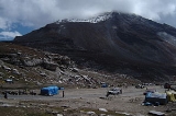
Rohtang Pass (altitude 13051 ft or 3,977.9 m), is a high mountain pass
on the eastern Pir Panjal Range
of the Himalayas some 51 km (31.7 mi) from Manali. It connects the Kullu Valley
with the Lahaul and Spiti Valleys of Himachal Pradesh
, India
.
culture (in the south), and the arid/semi-arid high-altitude Lahaul and Spiti valleys with a Buddhist culture (in the north). The pass lies on the watershed between the Chenab and Beas
Basins. On the southern side of this pass, the Beas River
emerges from underground and flows southward and on its northern side, the Chandra River, a source stream of the river Chenab, flows westward.
This pass is an ancient trade route between the people on either side of Pir Panjal. The local name for this pass is a generic name of pass. There are many other passes in Lahaul and Spiti which have specific names (Kunzam La, Baralacha La, etc.). This is suggestive of the fact that this must have been the oldest and most frequented pass in the region, or the fact that it is the main pass leading from one cultural region (Indian) to another, quite different one, to the north.
The road through the Kullu
Valley, past Manali and over the Rohtang Pass to Keylong
, and Lahul and on to Ladakh
, has become very busy during the summer months as an alternate military route, following the Kargil Conflict in 1999 in addition to tensions in Kashmir
. Traffic jams are common as military vehicles, trucks, and goods carriers try to navigate the tight roads and rough terrain, compounded by snow and ice at certain points and the large number of tourists vehicles. Partially due to the military significance of the pass, the Indian government began building the $320 million Rohtang Tunnel
project in 2010 which promises to create a year-around link which is much safer and faster.
Several episodes of the History Channel's Ice Road Truckers
series spinoff IRT Deadliest Roads dealt with truckers crossing the Rohtang Pass to deliver supplies.
Mountain pass
A mountain pass is a route through a mountain range or over a ridge. If following the lowest possible route, a pass is locally the highest point on that route...
on the eastern Pir Panjal Range
Pir Panjal Range
The Pir Panjal ranges lie in the Inner Himalayan region, running from east southeast to west northwest across the states of Himachal Pradesh and Kashmir in India as well as Pakistan-administered Kashmir, where the average elevation varies from to . The Himalayas show a gradual elevation towards...
of the Himalayas some 51 km (31.7 mi) from Manali. It connects the Kullu Valley
Kullu district
Kullu is a district in Himachal Pradesh, India. The district stretches from the village of Rampur in the south to the Rohtang Pass in the North....
with the Lahaul and Spiti Valleys of Himachal Pradesh
Himachal Pradesh
Himachal Pradesh is a state in Northern India. It is spread over , and is bordered by the Indian states of Jammu and Kashmir on the north, Punjab on the west and south-west, Haryana and Uttar Pradesh on the south, Uttarakhand on the south-east and by the Tibet Autonomous Region on the east...
, India
India
India , officially the Republic of India , is a country in South Asia. It is the seventh-largest country by geographical area, the second-most populous country with over 1.2 billion people, and the most populous democracy in the world...
.
Geography
The pass provides a natural divide between the sub-humid/humid Kullu Valley with a primarily HinduHindu
Hindu refers to an identity associated with the philosophical, religious and cultural systems that are indigenous to the Indian subcontinent. As used in the Constitution of India, the word "Hindu" is also attributed to all persons professing any Indian religion...
culture (in the south), and the arid/semi-arid high-altitude Lahaul and Spiti valleys with a Buddhist culture (in the north). The pass lies on the watershed between the Chenab and Beas
Beas River
The Beas River is a river in the northern part of India. The river rises in the Himalayas in central Himachal Pradesh, India, and flows for some 470 km to the Sutlej River in the Indian state of Punjab....
Basins. On the southern side of this pass, the Beas River
Beas River
The Beas River is a river in the northern part of India. The river rises in the Himalayas in central Himachal Pradesh, India, and flows for some 470 km to the Sutlej River in the Indian state of Punjab....
emerges from underground and flows southward and on its northern side, the Chandra River, a source stream of the river Chenab, flows westward.
Overview
The pass is open from May to November. It is not particularly high or difficult to cross on foot by Himalayan standards, but it has a well-deserved reputation for being dangerous because of unpredictable snowstorms and blizzards.This pass is an ancient trade route between the people on either side of Pir Panjal. The local name for this pass is a generic name of pass. There are many other passes in Lahaul and Spiti which have specific names (Kunzam La, Baralacha La, etc.). This is suggestive of the fact that this must have been the oldest and most frequented pass in the region, or the fact that it is the main pass leading from one cultural region (Indian) to another, quite different one, to the north.
The road through the Kullu
Kullu
Kullu, once known as Kul-anti-peetha - "the end of the habitable world", is the capital town of the Kullu District, in the state of Himachal Pradesh, India. It is located on the banks of the Beas River in the Kullu Valley about ten kilometres north of the airport at Bhuntar.Kullu is a broad open...
Valley, past Manali and over the Rohtang Pass to Keylong
Keylong
Keylong is the administrative centre of the Lahaul and Spiti district in the Indian state of Himachal Pradesh, some 120 kilometres from the Indo-Tibetan border....
, and Lahul and on to Ladakh
Ladakh
Ladakh is a region of Jammu and Kashmir, the northernmost state of the Republic of India. It lies between the Kunlun mountain range in the north and the main Great Himalayas to the south, inhabited by people of Indo-Aryan and Tibetan descent...
, has become very busy during the summer months as an alternate military route, following the Kargil Conflict in 1999 in addition to tensions in Kashmir
Kashmir
Kashmir is the northwestern region of the Indian subcontinent. Until the mid-19th century, the term Kashmir geographically denoted only the valley between the Great Himalayas and the Pir Panjal mountain range...
. Traffic jams are common as military vehicles, trucks, and goods carriers try to navigate the tight roads and rough terrain, compounded by snow and ice at certain points and the large number of tourists vehicles. Partially due to the military significance of the pass, the Indian government began building the $320 million Rohtang Tunnel
Rohtang Tunnel
Rohtang Tunnel is a tunnel proposed to be built under the Rohtang Pass in the Leh-Manali Highway. The tunnel will be the longest road tunnel in India and is expected to reduce the distance between Manali and Keylong by over Lying on the Manali-Leh axis, this is the only route to Ladakh, as the...
project in 2010 which promises to create a year-around link which is much safer and faster.
Several episodes of the History Channel's Ice Road Truckers
Ice Road Truckers
Ice Road Truckers is a documentary-style reality television series that premiered on History on June 17, 2007.-History:In 2000, History aired a 46-minute episode titled "Ice Road Truckers" as part of the Suicide Missions series...
series spinoff IRT Deadliest Roads dealt with truckers crossing the Rohtang Pass to deliver supplies.