

Robinson projection
Encyclopedia
Map projection
A map projection is any method of representing the surface of a sphere or other three-dimensional body on a plane. Map projections are necessary for creating maps. All map projections distort the surface in some fashion...
of a world map
World map
A world map is a map of the surface of the Earth, which may be made using any of a number of different map projections. A map projection is any method of representing the surface of a sphere or other three-dimensional body on a plane....
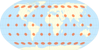
, which shows the entire world at once. It was specifically created in an attempt to find a good compromise to the problem of readily showing the whole globe as a flat image.
The Robinson projection is an accomplishment of Arthur H. Robinson
Arthur H. Robinson
Arthur H. Robinson was an American geographer and cartographer, who was professor in the Geography Department at the University of Wisconsin in Madison from 1947 until he retired in 1980...
in 1961, and has been in use by Rand McNally
Rand McNally
Rand McNally is an American publisher of maps, atlases, textbooks, and globes for travel, reference, commercial, and educational uses. It also provides online consumer street maps and directions, as well as commercial transportation routing software and mileage data...
since the 1960s and was used by the National Geographic Society
National Geographic Society
The National Geographic Society , headquartered in Washington, D.C. in the United States, is one of the largest non-profit scientific and educational institutions in the world. Its interests include geography, archaeology and natural science, the promotion of environmental and historical...
between 1988 and 1998. Since 1998, the National Geographic Society
National Geographic Society
The National Geographic Society , headquartered in Washington, D.C. in the United States, is one of the largest non-profit scientific and educational institutions in the world. Its interests include geography, archaeology and natural science, the promotion of environmental and historical...
has used the Winkel tripel projection
Winkel tripel projection
The Winkel Tripel projection , a modified azimuthal map projection, is one of three projections proposed by Oswald Winkel in 1921...
.
Strengths and weaknesses
The Robinson projection is neither equal-area nor conformalConformal map
In mathematics, a conformal map is a function which preserves angles. In the most common case the function is between domains in the complex plane.More formally, a map,...
, abandoning both for a compromise. The creator felt this produced a better overall view than could be achieved by adhering to either. The meridians
Meridian (geography)
A meridian is an imaginary line on the Earth's surface from the North Pole to the South Pole that connects all locations along it with a given longitude. The position of a point along the meridian is given by its latitude. Each meridian is perpendicular to all circles of latitude...
curve gently, avoiding extremes, but thereby stretch the poles into long lines instead of leaving them as points.
Hence, distortion close to the poles is severe, but quickly declines to moderate levels moving away from them. The straight parallels imply severe angular distortion at the high latitudes toward the outer edges of the map, a fault inherent in any pseudocylindrical projection. However, at the time it was developed, the projection effectively met Rand McNally's goal to produce appealing depictions of the entire world.
Specification
The projection is defined by the table:| Latitude | PLEN | PDFE |
|---|---|---|
| 00 | 1.0000 | 0.0000 |
| 05 | 0.9986 | 0.0620 |
| 10 | 0.9954 | 0.1240 |
| 15 | 0.9900 | 0.1860 |
| 20 | 0.9822 | 0.2480 |
| 25 | 0.9730 | 0.3100 |
| 30 | 0.9600 | 0.3720 |
| 35 | 0.9427 | 0.4340 |
| 40 | 0.9216 | 0.4958 |
| 45 | 0.8962 | 0.5571 |
| 50 | 0.8679 | 0.6176 |
| 55 | 0.8350 | 0.6769 |
| 60 | 0.7986 | 0.7346 |
| 65 | 0.7597 | 0.7903 |
| 70 | 0.7186 | 0.8435 |
| 75 | 0.6732 | 0.8936 |
| 80 | 0.6213 | 0.9394 |
| 85 | 0.5722 | 0.9761 |
| 90 | 0.5322 | 1.0000 |
The table is indexed by latitude, using interpolation
Interpolation
In the mathematical field of numerical analysis, interpolation is a method of constructing new data points within the range of a discrete set of known data points....
. The PLEN column is the length of the parallel of latitude, and the PDFE column is multiplied by 0.5072 to obtain the distance of that parallel from the equator. Meridians of longitude are equally spaced on each parallel of latitude.
Further reading
- Arthur H. RobinsonArthur H. RobinsonArthur H. Robinson was an American geographer and cartographer, who was professor in the Geography Department at the University of Wisconsin in Madison from 1947 until he retired in 1980...
(1974). "A New Map Projection: Its Development and Characteristics". In: International Yearbook of Cartography. Vol 14, 1974, pp. 145–155. - John B. Garver Jr. (1988). "New Perspective on the World". In: National Geographic, December 1988, pp. 911–913.
- John P. Snyder (1993). Flattening The Earth—2000 Years of Map Projections, The University of Chicago Press. pp. 214–216.
External links
- Table of examples and properties of all common projections, from radicalcartography.net
- An interactive Java Applet to study the metric deformations of the Robinson Projection.
- Numerical evaluation of the Robinson projection, from Cartography and Geographic Information Science, April, 2004 by Cengizhan Ipbuker