

Robert Moresby
Encyclopedia
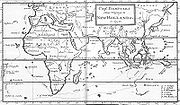
Capt. Moresby is a figure who has now all but disappeared from the records. But his vitally important feat in charting the dangerous waters of the Red Sea
Red Sea
The Red Sea is a seawater inlet of the Indian Ocean, lying between Africa and Asia. The connection to the ocean is in the south through the Bab el Mandeb strait and the Gulf of Aden. In the north, there is the Sinai Peninsula, the Gulf of Aqaba, and the Gulf of Suez...
and some archipelagoes of the Indian Ocean
Indian Ocean
The Indian Ocean is the third largest of the world's oceanic divisions, covering approximately 20% of the water on the Earth's surface. It is bounded on the north by the Indian Subcontinent and Arabian Peninsula ; on the west by eastern Africa; on the east by Indochina, the Sunda Islands, and...
, like the Maldives
Maldives
The Maldives , , officially Republic of Maldives , also referred to as the Maldive Islands, is an island nation in the Indian Ocean formed by a double chain of twenty-six atolls oriented north-south off India's Lakshadweep islands, between Minicoy Island and...
, Laccadives and Chagos in the 1820s and '30s ensured that the route from Europe to the East Indies became viable for the new steam vessels.
Robert had 6 brothers and 3 sisters. His eldest brother was Sir Fairfax Moresby
Fairfax Moresby
Admiral of the Fleet Sir Fairfax Moresby GCB , born in Calcutta, India, to English parents was a British naval officer.-Early life:Moresby was the eldest son of Fairfax Moresby, Lieut...
, Admiral of the British Fleet, and Commander in Chief, Channel Squadron and Pacific Station.
The East India Route and the New Era of Trade and Communication
In the nineteenth century, the sea route between the Mediterranean SeaMediterranean Sea
The Mediterranean Sea is a sea connected to the Atlantic Ocean surrounded by the Mediterranean region and almost completely enclosed by land: on the north by Anatolia and Europe, on the south by North Africa, and on the east by the Levant...
and India
India
India , officially the Republic of India , is a country in South Asia. It is the seventh-largest country by geographical area, the second-most populous country with over 1.2 billion people, and the most populous democracy in the world...
would come to play a key role in a new era of communication. Already before the opening of the Suez Canal
Suez Canal
The Suez Canal , also known by the nickname "The Highway to India", is an artificial sea-level waterway in Egypt, connecting the Mediterranean Sea and the Red Sea. Opened in November 1869 after 10 years of construction work, it allows water transportation between Europe and Asia without navigation...
, industrial Britain, had a rapidly expanding economy, and needed improved communication with British India, with its raw materials and imperial requirements. Crucial in the development of the Red Sea
Red Sea
The Red Sea is a seawater inlet of the Indian Ocean, lying between Africa and Asia. The connection to the ocean is in the south through the Bab el Mandeb strait and the Gulf of Aden. In the north, there is the Sinai Peninsula, the Gulf of Aqaba, and the Gulf of Suez...
route between the two countries was the harnessing of steam power, most notably in the form of the marine steam engine
Marine steam engine
A marine steam engine is a reciprocating steam engine that is used to power a ship or boat. Steam turbines and diesel engines largely replaced reciprocating steam engines in marine applications during the 20th century, so this article describes the more common types of marine steam engine in use...
.
A further vital factor in this revolution in trade and transport was the charting of the hazardous waterway commissioned by the British East India Company
British East India Company
The East India Company was an early English joint-stock company that was formed initially for pursuing trade with the East Indies, but that ended up trading mainly with the Indian subcontinent and China...
and carried out by the little-known naval commander Robert Moresby and his colleague Thomas Elwon, both of the Bombay Marine
Royal Navy
The Royal Navy is the naval warfare service branch of the British Armed Forces. Founded in the 16th century, it is the oldest service branch and is known as the Senior Service...
, later the Indian Navy
Royal Navy
The Royal Navy is the naval warfare service branch of the British Armed Forces. Founded in the 16th century, it is the oldest service branch and is known as the Senior Service...
.
Lack of accurate maps
The Red sea is full of navigational hazards, but at that crucial time, reliable charts were not available. Preliminary surveys of the Red Sea route had been published in 1826–27 by James HorsburghJames Horsburgh
James Horsburgh was a Scottish hydrographer. He worked for East India Company, who mapped many seaways around Singapore in the late 18th century and early 19th century....
, hydrographer to the East India Company
British East India Company
The East India Company was an early English joint-stock company that was formed initially for pursuing trade with the East Indies, but that ended up trading mainly with the Indian subcontinent and China...
. Horsburgh's work provided a good foundation, but also highlighted the limitations' of existing knowledge. By this time, the marine steam engine
Steam engine
A steam engine is a heat engine that performs mechanical work using steam as its working fluid.Steam engines are external combustion engines, where the working fluid is separate from the combustion products. Non-combustion heat sources such as solar power, nuclear power or geothermal energy may be...
appeared to be racing to the rescue of British communications with India; the engine, first tested on Scottish lochs and American rivers, was by 1826 attempting the Cape
Cape Province
The Province of the Cape of Good Hope was a province in the Union of South Africa and subsequently the Republic of South Africa...
route to India
India
India , officially the Republic of India , is a country in South Asia. It is the seventh-largest country by geographical area, the second-most populous country with over 1.2 billion people, and the most populous democracy in the world...
.
In that year a 479-ton wooden paddle steamer
Paddle steamer
A paddle steamer is a steamship or riverboat, powered by a steam engine, using paddle wheels to propel it through the water. In antiquity, Paddle wheelers followed the development of poles, oars and sails, where the first uses were wheelers driven by animals or humans...
, HMS Enterprise, steamed (mostly sailed in fact) from London to Calcutta. Its progress was particularly noted by two individuals — a river pilot named Thomas Waghorn who was impressed by the steamer's steady progress against the wind up the Hooghly river to Calcutta, and indirectly by the Governor of Bombay, Mountstuart Elphinstone
Mountstuart Elphinstone
Mountstuart Elphinstone was a Scottish statesman and historian, associated with the government of British India. He later became the Governor of Bombay where he is credited with the opening of several educational institutions accessible to the Indian population...
. A year later Elphinstone, together with the secretary of the Calcutta government and his wife, Mr and Mrs Lushington, chose to return to England via the Red Sea, sailing on a cramped little brig, HMS Palinurus. This involved disembarking at Qusayr and crossing the desert to the Nile
Nile
The Nile is a major north-flowing river in North Africa, generally regarded as the longest river in the world. It is long. It runs through the ten countries of Sudan, South Sudan, Burundi, Rwanda, Democratic Republic of the Congo, Tanzania, Kenya, Ethiopia, Uganda and Egypt.The Nile has two major...
in the customary four days. Back in Britain Elphinstone joined the campaign, promoted by the visionary new commander of the Bombay Marine (re-named the Indian Navy
Indian Navy
The Indian Navy is the naval branch of the armed forces of India. The President of India serves as the Commander-in-Chief of the Navy. The Chief of Naval Staff , usually a four-star officer in the rank of Admiral, commands the Navy...
in 1832), Sir Charles Malcolm, to introduce steam to the Red Sea, which would enable boats to navigate up the Gulf of Suez against those tiresome northerlies.
Waghorn and other entrepreneurs in Britain and Egypt were meanwhile working at linking Mediterranean steam crossings (already overcoming its infuriating calms) with the Red Sea via an 'overland route' through Egypt. An experimental vessel, HMS Hugh Lindsay, was built in Bombay, powered by engines sent from England, and launched for Suez
Suez
Suez is a seaport city in north-eastern Egypt, located on the north coast of the Gulf of Suez , near the southern terminus of the Suez Canal, having the same boundaries as Suez governorate. It has three harbors, Adabya, Ain Sokhna and Port Tawfiq, and extensive port facilities...
in 1829; a collier loaded with Welsh coal (sent via the Cape) went ahead, convoyed by a sailing brig, HMS Thetis. Captained by a real steam enthusiast, James Wilson, she made it to Suez in thirty-four days but the collier was later wrecked on a reef, a fate which narrowly missed befalling the Thetis, on a reef subsequently named after her, just south of Yanbu on the north Arabian coast.
Robert Moresby Begins the Survey of the Red Sea
Drastic measures were clearly needed to prevent these disasters and two small brigs were made ready for cartographical work despite the reluctance of the East India CompanyBritish East India Company
The East India Company was an early English joint-stock company that was formed initially for pursuing trade with the East Indies, but that ended up trading mainly with the Indian subcontinent and China...
in London
London
London is the capital city of :England and the :United Kingdom, the largest metropolitan area in the United Kingdom, and the largest urban zone in the European Union by most measures. Located on the River Thames, London has been a major settlement for two millennia, its history going back to its...
to provide finance. One was HMS Palinurus, the same vessel that had transported the Elphinstone party to Qusayr in 1827. She was captained by Robert Moresby, who had already gained experience from having surveyed the Laccadive Islands. The second vessel was HMS Benares, under the captaincy of Thomas Elwon. Each had a complement of around ten officers.
Initially Moresby was appointed to the far less known northern half of the Red Sea. His base was at Suez
Suez
Suez is a seaport city in north-eastern Egypt, located on the north coast of the Gulf of Suez , near the southern terminus of the Suez Canal, having the same boundaries as Suez governorate. It has three harbors, Adabya, Ain Sokhna and Port Tawfiq, and extensive port facilities...
, seen as the terminus of Waghorn's much trumpeted Overland Route, which connected the Mediterranean with the Indian Ocean via Egypt
Egypt
Egypt , officially the Arab Republic of Egypt, Arabic: , is a country mainly in North Africa, with the Sinai Peninsula forming a land bridge in Southwest Asia. Egypt is thus a transcontinental country, and a major power in Africa, the Mediterranean Basin, the Middle East and the Muslim world...
and the Red Sea. Elwon was despatched to the south, but in 1833 he was transferred to the Persian Gulf leaving Moresby to complete the full survey.Sarah Searight, The Charting of the Red Sea. History Today, 2003
From 1829 to 1833 Moresby never left the Red Sea.
Survey of the Red Sea and its Hazards
Between 1829 and 1833 Robert Moresby completed a full survey of the Red SeaRed Sea
The Red Sea is a seawater inlet of the Indian Ocean, lying between Africa and Asia. The connection to the ocean is in the south through the Bab el Mandeb strait and the Gulf of Aden. In the north, there is the Sinai Peninsula, the Gulf of Aqaba, and the Gulf of Suez...
with HMS Palinurus and HMS Benares. Moresby began his survey in the north, first in the two Gulfs and along the Arabian coast south to Jiddah, then north-south down the African coast. However, his Sailing Directions for the Red Sea, published in 1841, charts the Sea from south to north. Every detail is noted, not only reefs, harbours and anchorages but also provisions, the essential water (often awful) and fuel supplies. A fuller and more graphic narrative of the upper half of the survey is contained in Lieutenant J.R. Wellsted's account, in the second volume of his Travels in Arabia (1838). Wellsted had joined, the Palinurus in 1830. The reefs were mostly surveyed from local boats with local pilots.
This survey was an arduous task and the ships suffered. The Palinurus had been forced to return to Bombay in 1830 for refitting after surveying the Gulf of Suez
Suez
Suez is a seaport city in north-eastern Egypt, located on the north coast of the Gulf of Suez , near the southern terminus of the Suez Canal, having the same boundaries as Suez governorate. It has three harbors, Adabya, Ain Sokhna and Port Tawfiq, and extensive port facilities...
, while the Benares had to be sent back in 1831 in a shattered state, the leaky tub caught forty-two times on coral reefs).
"This heated funnel of reef-bound sea" as Moresby referred to it, took its toll on the surveyors; "great dangers and privations were inseparable from such a service", Moresby noted. The summer months were particularly punishing when temperatures reached the high 40°s and the Benares seems to have been especially vulnerable. It was rare for the full complement of officers to be functioning and Elwon himself was frequently ill. In 1833 the assistant surveyor, Lieutenant Pinching, died of smallpox
Smallpox
Smallpox was an infectious disease unique to humans, caused by either of two virus variants, Variola major and Variola minor. The disease is also known by the Latin names Variola or Variola vera, which is a derivative of the Latin varius, meaning "spotted", or varus, meaning "pimple"...
off Aden
Aden
Aden is a seaport city in Yemen, located by the eastern approach to the Red Sea , some 170 kilometres east of Bab-el-Mandeb. Its population is approximately 800,000. Aden's ancient, natural harbour lies in the crater of an extinct volcano which now forms a peninsula, joined to the mainland by a...
where he was buried.
Starting from Suez
Suez
Suez is a seaport city in north-eastern Egypt, located on the north coast of the Gulf of Suez , near the southern terminus of the Suez Canal, having the same boundaries as Suez governorate. It has three harbors, Adabya, Ain Sokhna and Port Tawfiq, and extensive port facilities...
, as the nearest point to Cairo
Cairo
Cairo , is the capital of Egypt and the largest city in the Arab world and Africa, and the 16th largest metropolitan area in the world. Nicknamed "The City of a Thousand Minarets" for its preponderance of Islamic architecture, Cairo has long been a centre of the region's political and cultural life...
for those crossing Egypt
Egypt
Egypt , officially the Arab Republic of Egypt, Arabic: , is a country mainly in North Africa, with the Sinai Peninsula forming a land bridge in Southwest Asia. Egypt is thus a transcontinental country, and a major power in Africa, the Mediterranean Basin, the Middle East and the Muslim world...
by the Overland Route, Moresby worked a system of triangulation
Triangulation
In trigonometry and geometry, triangulation is the process of determining the location of a point by measuring angles to it from known points at either end of a fixed baseline, rather than measuring distances to the point directly...
down each shore. At Suez itself he noted, "provisions are plentiful and good—oranges, pears, apples, plums in season. And there were plenty of fine cabbages!" In the Gulf there were some nasty spots whose names indicate the hazards—Moresby Shoal for instance, and Felix Jones Patches. Another danger spot was the Daedalus Shoal at the entrance to the Gulf of Suez, which has a light on it to this day.
Moresby also surveyed the Gulf of Aqaba
Gulf of Aqaba
The Gulf of Aqaba is a large gulf located at the northern tip of the Red Sea. In pre twentieth-century and modern sources it is often named the Gulf of Eilat, as Eilat is its predominant Israeli city ....
, a narrow deep waterway between high mountains that funnels high northerly winds. It was such winds, so frequently mentioned in the Sailing Directions, which the steam engine was supposed to overcome. The six-kilometre-wide entrance, at the Straits of Tiran
Tiran
Tiran may refer to:* Tiran of Armenia, a 4th century AD king of Armenia* Tiran, Iran, a city in Isfahan Province, Iran* Tiran, Lorestan, a village in Lorestan Province, Iran* Straits of Tiran, Red Sea...
, was bad enough—wrecks are strewn over the rocks there even today. In the Gulf itself on one occasion the Palinurus was blown off her anchorage three times and only managed to stay put with fifty fathoms (90 m) of chain on each of two anchors.
Wellsted describes Moresby on one occasion springing up the rigging to spot reefs which everyone had declared were just wash from clashing tides; they lowered anchors to three fathoms but the vessel swung round and suddenly there was no bottom under the stem at eighty fathoms. In Wellsted's opinion four years in the Red Sea was nothing like as bad as 150 kilometres in the Gulf of Aqaba. On shore the crew helped locals repair their boats and Moresby going for a walk along the beach was accosted by fishermen whose boat had been thus mended, who insisted on his accepting a present of two sheep and a bag of dollars.
Heading out of the Gulf and down the Arabian coast a particular danger spot was Zabarga Island (also known as St John's or Emerald Island because of ancient peridot
Peridot
-Chemistry:The chemical composition of peridot is 2SiO4, with Mg in greater quantities than Fe.-Etymology:The origin of the name "peridot" is uncertain...
mines); Palinurus was caught in a fearsome gale and only avoided being driven on to the rocks by hooking a kedge anchor on to a hole in the reef. "An uncomfortable night was spent by all."
Moresby always records the availability or otherwise of fuel, provisions, water, attitude of locals: availability of water was sometimes dependent on their being able to roll the ship's casks to and from the source. Onshore reception was variable owing to the long tradition of piracy in the northern end of the Red Sea. Moresby warned that "should a ship touch at any part of the Red Sea not frequented by Europeans (for water, etc.), great caution ought to be adopted, to guard against treachery from the various predatory tribes inhabiting the borders of the sea."
The coastal plain had been devastated earlier in the century by Wahhabi puritan Muslims from Central Arabia followed by an Egyptian invasion — none of this good news for non-Muslims. At Sharm Ghabur ('sharm' meaning a channel through the reefs in the local Arabic), where Muslim pilgrims traditionally donned their pilgrim's garb, "water and wood were cheap, and dates excellent, but the bedu were not to be trusted. They were feared throughout the sea for ferocity and treachery," writes Moresby, "so that it is dangerous to land on that stretch of shore."
During the survey of the Red Sea Robert Moresby was smitten by intermittent fevers. Finally Moresby returned to Bombay in 1833, exhausted by four years of surveying. Meanwhile the valiant HMS Palinurus sailed on to survey the southern coast of Arabia under Captain Haines who would later become the first British official in charge of the Protectorate of Aden
Aden
Aden is a seaport city in Yemen, located by the eastern approach to the Red Sea , some 170 kilometres east of Bab-el-Mandeb. Its population is approximately 800,000. Aden's ancient, natural harbour lies in the crater of an extinct volcano which now forms a peninsula, joined to the mainland by a...
.
The Red Sea charts of Moresby and Elwon were drafted by chief draughtsman Felix Jones to a scale of one inch to the mile (in the trickier parts, ten inches to the mile), and published in 1834.Sarah Searight, The Charting of the Red Sea. History Today, 2003
Other important surveys: the Maldives and the Chagos
After the completion of the Red SeaRed Sea
The Red Sea is a seawater inlet of the Indian Ocean, lying between Africa and Asia. The connection to the ocean is in the south through the Bab el Mandeb strait and the Gulf of Aden. In the north, there is the Sinai Peninsula, the Gulf of Aqaba, and the Gulf of Suez...
Survey, Robert Moresby was sent to chart various coral island groups lying across the track of India
India
India , officially the Republic of India , is a country in South Asia. It is the seventh-largest country by geographical area, the second-most populous country with over 1.2 billion people, and the most populous democracy in the world...
-to-Cape
Cape Province
The Province of the Cape of Good Hope was a province in the Union of South Africa and subsequently the Republic of South Africa...
trade. In 1834–36 Moresby, assisted by Lieutenants Christopher and Young, undertook the difficult cartography
Cartography
Cartography is the study and practice of making maps. Combining science, aesthetics, and technique, cartography builds on the premise that reality can be modeled in ways that communicate spatial information effectively.The fundamental problems of traditional cartography are to:*Set the map's...
of the Maldive Islands, drawing the first accurate maritime charts of this complicated Indian Ocean atoll group (Admiralty Charts). These charts were printed as three separate large maps by the Hydrographic Service of the Royal Navy.
Moresby's survey of the Atolls of the Maldives
Atolls of the Maldives
The Maldives are formed by a number of natural atolls plus atolls in the form of a few islands and isolated reefs today which form a pattern stretching from 7 degrees 10' North to 0 degrees 45' South....
was followed by the Chagos Archipelago
Chagos Archipelago
The Chagos Archipelago , is a group of seven atolls comprising more than 60 individual tropical islands in the Indian Ocean; situated some due south of the Maldives archipelago. This chain of islands are the southernmost archipelago of the Chagos-Laccadive Ridge a long submarine mountain range...
. where he conducted "a thorough scientific survey". He planted 30 breadfruit trees in Diego Garcia
Diego Garcia
Diego Garcia is a tropical, footprint-shaped coral atoll located south of the equator in the central Indian Ocean at 7 degrees, 26 minutes south latitude. It is part of the British Indian Ocean Territory [BIOT] and is positioned at 72°23' east longitude....
Island, the largest of the group. Moresby reported that "there were cats and chickens on the island". Some of his observations were used by Darwin
Charles Darwin
Charles Robert Darwin FRS was an English naturalist. He established that all species of life have descended over time from common ancestry, and proposed the scientific theory that this branching pattern of evolution resulted from a process that he called natural selection.He published his theory...
in his 1842 book "The Structure and Distribution of Coral Reefs."
In 1838, after leaving the Chagos, Robert Moresby went on to survey the Saya de Malha bank. This is a vast submerged reef south-east of the Seychelles
Seychelles
Seychelles , officially the Republic of Seychelles , is an island country spanning an archipelago of 115 islands in the Indian Ocean, some east of mainland Africa, northeast of the island of Madagascar....
and since there is no island above the surface, the men were forced to spend many days at sea often under difficult weather conditions. Moresby could only complete part of this survey, namely the Southern Bank, for this arduous task and the accumulated fatigue from his previous surveys, took a toll on his health. Thus Robert Moresby had to interrupt the task and the Northern Bank of Saya da Malha could not be satisfactorily surveyed. He sailed then back to India, for a much needed time of rest for him and his crew.
Even after the necessary period of relaxation Moresby didn't fully recover. Finally his precarious condition obliged him to give up surveying.
In 1842 he was employed by Peninsular & Oriental, better known as P&O
Peninsular and Oriental Steam Navigation Company
The Peninsular and Oriental Steam Navigation Company, which is usually known as P&O, is a British shipping and logistics company which dated from the early 19th century. Following its sale in March 2006 to Dubai Ports World for £3.9 billion, it became a subsidiary of DP World; however, the P&O...
, to command their brand new and most luxurious steamer, HMS Hindostan, on her maiden voyage from Southampton
Southampton
Southampton is the largest city in the county of Hampshire on the south coast of England, and is situated south-west of London and north-west of Portsmouth. Southampton is a major port and the closest city to the New Forest...
to Calcutta. Subsequently the Hindostan was employed on the Calcutta-Suez run, the Red Sea now made safe by the immaculate surveys led by Moresby and Elwon.
Moresby's charts were so good that they were favoured by Maldivian pilots navigating through the treacherous waters of their atolls until the 1990s, when satellite images appeared. In the Maldives a channel locally also known as Hanikandu, between Northern Maalhosmadulhu Atoll
Northern Maalhosmadulhu Atoll
Northern Maalhosmadulu Atoll is an atoll from the Maldives. It includes Northern Maalhosmadulu Atoll proper and the island of Alifushi....
and "Fasdhūtere" Atoll, is still known as 'Moresby Channel' in the honor of this forgotten captain and draughtsman, who with much patience and hard work charted all the Atolls of the Maldives
Atolls of the Maldives
The Maldives are formed by a number of natural atolls plus atolls in the form of a few islands and isolated reefs today which form a pattern stretching from 7 degrees 10' North to 0 degrees 45' South....
.Xavier Romero-Frias
Xavier Romero-Frias
Xavier Romero-Frias , is a Spanish writer and scholar. He lived in the Maldives over a 13-year period. His present residence is in Bangkok, Thailand.-Works:...
, The Maldive Islanders, A Study of the Popular Culture of an Ancient Ocean Kingdom. Barcelona 1999
Moresby Island, an island in Peros Banhos
Peros Banhos
Peros Banhos, Pedro dos Banhos or Baixo de Pero dos Banhos in old maps, is a formerly inhabited atoll in the Chagos Archipelago of the British Indian Ocean Territory....
Atoll in the Chagos Archipelago
Chagos Archipelago
The Chagos Archipelago , is a group of seven atolls comprising more than 60 individual tropical islands in the Indian Ocean; situated some due south of the Maldives archipelago. This chain of islands are the southernmost archipelago of the Chagos-Laccadive Ridge a long submarine mountain range...
has been named after this skilled British cartographer as well. However, Robert Moresby should not be confused with Admiral Sir Fairfax Moresby
Fairfax Moresby
Admiral of the Fleet Sir Fairfax Moresby GCB , born in Calcutta, India, to English parents was a British naval officer.-Early life:Moresby was the eldest son of Fairfax Moresby, Lieut...
, also of the British Navy, after which Port Moresby
Port Moresby
Port Moresby , or Pot Mosbi in Tok Pisin, is the capital and largest city of Papua New Guinea . It is located on the shores of the Gulf of Papua, on the southeastern coast of the island of New Guinea, which made it a prime objective for conquest by the Imperial Japanese forces during 1942–43...
, the capital of Papua New Guinea, was named. Fairfax Moresby was Robert's eldest brother.
Sir Richard Burton's Eulogy
Robert Moresby, the genius of the Red Sea, conducted also the survey of the Maldive Islands and groups known as the Chagos Archipelago. He narrowly escaped being a victim to the deleterious climate of his station, and only left it when no longer capable of working. A host of young and ardent officers, Christopher, Young, Powell, Campbell, Jones, Barker, and others, ably seconded him: death was busy amongst them for months and so paralyzed by disease were the living, that the anchors could scarcely be raised for a retreat to the coast of India.Renovated by a three months’ stay, occasionally in port, where they were strengthened by additional numbers, the undaunted remnants from time to time returned to their task; and in 1837, gave to the world a knowledge of those singular groups which heretofore “though within 150 miles of our coasts” had been a mystery hidden within the dangers that environed them. The beautiful maps of the Red Sea, drafted by the late Commodore Carless, then a lieutenant, will ever remain permanent monuments of Indian Naval Science, and the daring of its officers and men. Those of the Maldive and Chagos groups, executed by Commander then Acting Lieutenant Felix Jones, were, we hear, of such a high order, that they were deemed worthy of special inspection by the Queen.Burton, Richard
Richard Francis Burton
Captain Sir Richard Francis Burton KCMG FRGS was a British geographer, explorer, translator, writer, soldier, orientalist, cartographer, ethnologist, spy, linguist, poet, fencer and diplomat. He was known for his travels and explorations within Asia, Africa and the Americas as well as his...
. First footsteps in East Africa