
.gif)
Roaring Fork (Great Smoky Mountains)
Encyclopedia
Roaring Fork is a stream in the Great Smoky Mountains
of Tennessee
, located in the Southeastern United States
. Once the site of a small Appalachian community, today the stream's area is home to the Roaring Fork Motor Nature Trail and the Roaring Fork Historic District.
Like many mountain streams, Roaring Fork is volatile. While the stream presents as a peaceful trickle on any given day, it quickly becomes a raging whitewater rapid after a mild rain shower. The "roar" of the water is amplified by its echo
on surrounding mountain ridges.
 The source of Roaring Fork is located nearly 5000 feet (1,524 m) up along the northern slopes of Mount Le Conte, where several small springs converge. The highest of these springs, known as Basin Spring, provides the water source for LeConte Lodge. From its source, Roaring Fork drops 2500 feet (762 m) over just two miles (3 km), spilling over Grotto Falls and absorbing Surry Creek before steadying in a narrow valley between Mount Winnesoka and Piney Mountain. The mouth of Roaring Fork is located at the northern end of Gatlinburg
, where it empties into the West Fork of the Little Pigeon River
.
The Roaring Fork valley is underlain by Precambrian
sandstone
of the Ocoee Supergroup, a rock formation formed from ancient ocean sediments nearly a billion years ago. Roaring Fork Sandstone is found throughout the mid-level elevations of the northern Smokies, and is especially common in Greenbrier
to the east and the Sugarlands to the west. Over thousands of years, erosional forces have carried boulders composed of this sandstone down from boulder fields located higher up along the mountain ridges. This process has left the streambed of Roaring Fork and the flats in the Roaring Fork valley virtually covered with sandstone rocks of all sizes. Farmers who lived at Roaring Fork, the Sugarlands, and Greenbrier were continually moving and stacking these rocks, creating the characteristic rock walls that still criss-cross these areas today.
 Between 1800 and 1810, the first permanent Euro-American settlers arrived in the White Oak Flats area around what is now Gatlinburg. In the following decades, their descendants spread out into the surrounding coves and valleys. Richard Reagan (1776–1829), the son of one of these pioneers, settled on a large plot of land just south of Gatlinburg along LeConte Creek. Some of Reagan's children settled to the west in the Sugarlands, while some of them moved east to the hollow along Roaring Fork, which was then known as "Spruce Flats." By 1900, three of Reagan's grandsons, Alfred Reagan (1856–1928), Aaron Reagan, and John H. Reagan were still farming along the stream, just above Gatlinburg.
 The Bales family settled in the upper section of Roaring Fork sometime in the 1830s or earlier. Caleb Bales (1839–1913), apparently a son or nephew of the first Bales to settle on Roaring Fork, owned a farm just south of the Reagan lands. Caleb's sons Jim Bales (1869–1939) and Ephraim Bales (1867–1936) would spend most of their lives on Roaring Fork farming land inherited from their father.
As the Bales and Reagan families lived on adjoining lands, it's no surprise that they intermarried. Caleb Bales married one of Richard Reagan's granddaughters, Elizabeth, in 1861. Ephraim Bales married a great-granddaughter of Richard Reagan, Minerva, in 1889. Caleb's daughter, Martha, married Alfred Reagan in 1879.
Uppermost on Roaring Fork, near where the stream absorbs Surry Creek, were farms owned by the Clabo family, Gilbert Ogle, and Jasper Mellinger. Former homesteads can usually be identified by the preponderance of young tuliptrees (rather than the more common hemlock or oak), as tuliptrees are the quickest to reclaim previously-cultivated land.
Around 1850, the residents of Roaring Fork constructed a crude road connecting the area to White Oak Flats (this old road is now a stop along the Roaring Fork Motor Nature Trail). By 1900, the community had matured into a mountain hamlet with its own school, church, general store, and tub mills.
In 1976, the Roaring Fork Historic District was listed on the National Register of Historic Places
.
When the Park Service
gained control of the land in the 1930s, the frame house was torn down. The Alex Cole Cabin, being more representative of the pioneer days of Appalachia, was moved to the farm from the Sugarlands. Bales' corn crib
and barn remain, however.
 Just below the Jim Bales place is the farm of Ephraim and Minerva Bales. Ephraim, Jim Bales' older brother, farmed some 30 acres (121,405.8 m²) of his 70 acres (283,280.2 m²) plot. The other 40 acres (161,874.4 m²) were mostly wooded, which the Bales family used for construction material and firewood.
The Bales cabin was a double cabin with a passageway known as a "dog trot" in between. Dog-trot cabins, which are fairly common throughout the southeastern U.S., typically involve two adjacent cabins with roughly 10 feet (3 m) in between, but with one continuous roof. The space between the two halves was relatively cool in summer and warm in winter, making it attractive to dogs. Both halves of the cabin have their own chimney. With the exception of a back porch, the cabin remains largely as it was when the Bales family lived in here in the early 1900s.
Along with the cabin, Bales' corn crib, hog pen, and barn are still standing today, just a few yards from the cabin. A rock wall and paling fence behind the cabin are representative of the two major barriers used in the Northern Smokies in the late 19th and early 20th centuries.
 Alfred Reagan, a descendant of the area's first settlers, owned a small farm just below the Ephraim Bales Place. Reagan was a jack-of-all-trades, operating the Roaring Fork community's blacksmith shop, general store, and its most consistent grist mill. Reagan was also a part-time preacher at the Roaring Fork Church, for which he donated the land and helped build.
Of all the buildings on Reagan's farm, only his cabin and mill remain today. Due to its sawboard paneling and coat of paint, Reagan's cabin stands out among historical structures in the Smokies today. The cabin's design is known as a "saddlebag" design, which involves two cabins constructed around a single chimney. A kitchen area was added later.
The Reagan mill is a standard tub mill, with a flume redirecting water from Roaring Fork to power a tub-wheel turbine. The turbine turns a grindstone which breaks down corn and wheat into cornmeal and flour. Reagan's mill was well-designed and well-positioned. It is said that when other mills lacked sufficient water power due to low water levels, Reagan's mill would continue to operate.
is the last surviving structure from the Sugarlands community proper. Built by mountain guide Albert Alexander Cole, it has been moved from its original site to the Jim Bales Place along the Roaring Fork Motor Nature Trail.
The trail begins just past the Rainbow Falls Trailhead on Cherokee Orchard Road, and slowly ascends Piney Mountain, topping out at an overlook on the mountain's northern slopes (the overlook's elevation is roughly 3,000 feet/914 meters). Just past the overlook, the road passes numerous large chestnut tree
blowdowns. These trees, which often grew to 5–6 feet in diameter, were killed off by a blight in the 1930s.
As the road descends Piney Mountain, it passes a parking lot at the Trillium Gap Trail
head. This hiking trail leads past Grotto Falls and Trillium Gap en route to the summit of Mount Le Conte. Trillium Gap — the gap between Brushy Mountain and the main Le Conte massif — was named by Horace Albright, who observed the trillium
-filled area in the 1920s.
Past the Trillium Gap Trailhead, the road steadies as it enters the upper reaches of the Roaring Fork hollow. Patches of young tuliptrees mark the former location of the Clabo and Ogle farms. Immediately after the road crosses Roaring Fork, the Jim Bales Place is visible on the right (east). The Grapeyard Ridge Trail, which connects Roaring Fork to Greenbrier, begins just behind the barn. Past the Jim Bales Place are the Ephraim Bales Place and Alfred Reagan Place.
The road continues to descend past the historic district, passing along the way a parking lot that allows for an upclose view of Roaring Fork. A thin waterfall known as "The Place of a Thousand Drips" is the last stop along the motor trail before it re-enters Gatlinburg.
Great Smoky Mountains
The Great Smoky Mountains are a mountain range rising along the Tennessee–North Carolina border in the southeastern United States. They are a subrange of the Appalachian Mountains, and form part of the Blue Ridge Physiographic Province. The range is sometimes called the Smoky Mountains or the...
of Tennessee
Tennessee
Tennessee is a U.S. state located in the Southeastern United States. It has a population of 6,346,105, making it the nation's 17th-largest state by population, and covers , making it the 36th-largest by total land area...
, located in the Southeastern United States
United States
The United States of America is a federal constitutional republic comprising fifty states and a federal district...
. Once the site of a small Appalachian community, today the stream's area is home to the Roaring Fork Motor Nature Trail and the Roaring Fork Historic District.
Like many mountain streams, Roaring Fork is volatile. While the stream presents as a peaceful trickle on any given day, it quickly becomes a raging whitewater rapid after a mild rain shower. The "roar" of the water is amplified by its echo
Echo (phenomenon)
In audio signal processing and acoustics, an echo is a reflection of sound, arriving at the listener some time after the direct sound. Typical examples are the echo produced by the bottom of a well, by a building, or by the walls of an enclosed room and an empty room. A true echo is a single...
on surrounding mountain ridges.
Geography
Gatlinburg, Tennessee
Gatlinburg is a mountain resort city in Sevier County, Tennessee, United States. As of the 2000 U.S. Census, Gatlinburg had a population of 3,828. The city is a popular vacation resort, as it rests on the border of the Great Smoky Mountains National Park along U.S...
, where it empties into the West Fork of the Little Pigeon River
Little Pigeon River (Tennessee)
The Little Pigeon River is a river located entirely within Sevier County, Tennessee.It rises from a series of streams which flow together on the dividing ridge between the states of Tennessee and North Carolina inside the boundary of the Great Smoky Mountains National Park. The river is subdivided...
.
The Roaring Fork valley is underlain by Precambrian
Precambrian
The Precambrian is the name which describes the large span of time in Earth's history before the current Phanerozoic Eon, and is a Supereon divided into several eons of the geologic time scale...
sandstone
Sandstone
Sandstone is a sedimentary rock composed mainly of sand-sized minerals or rock grains.Most sandstone is composed of quartz and/or feldspar because these are the most common minerals in the Earth's crust. Like sand, sandstone may be any colour, but the most common colours are tan, brown, yellow,...
of the Ocoee Supergroup, a rock formation formed from ancient ocean sediments nearly a billion years ago. Roaring Fork Sandstone is found throughout the mid-level elevations of the northern Smokies, and is especially common in Greenbrier
Greenbrier (Great Smoky Mountains)
Greenbrier is a valley in the northern Great Smoky Mountains of Tennessee, located in the Southeastern United States. Now a recreational area, Greenbrier was once home to a string of Appalachian communities....
to the east and the Sugarlands to the west. Over thousands of years, erosional forces have carried boulders composed of this sandstone down from boulder fields located higher up along the mountain ridges. This process has left the streambed of Roaring Fork and the flats in the Roaring Fork valley virtually covered with sandstone rocks of all sizes. Farmers who lived at Roaring Fork, the Sugarlands, and Greenbrier were continually moving and stacking these rocks, creating the characteristic rock walls that still criss-cross these areas today.
Roaring Fork Historic District
As the Bales and Reagan families lived on adjoining lands, it's no surprise that they intermarried. Caleb Bales married one of Richard Reagan's granddaughters, Elizabeth, in 1861. Ephraim Bales married a great-granddaughter of Richard Reagan, Minerva, in 1889. Caleb's daughter, Martha, married Alfred Reagan in 1879.
Uppermost on Roaring Fork, near where the stream absorbs Surry Creek, were farms owned by the Clabo family, Gilbert Ogle, and Jasper Mellinger. Former homesteads can usually be identified by the preponderance of young tuliptrees (rather than the more common hemlock or oak), as tuliptrees are the quickest to reclaim previously-cultivated land.
Around 1850, the residents of Roaring Fork constructed a crude road connecting the area to White Oak Flats (this old road is now a stop along the Roaring Fork Motor Nature Trail). By 1900, the community had matured into a mountain hamlet with its own school, church, general store, and tub mills.
In 1976, the Roaring Fork Historic District was listed on the National Register of Historic Places
National Register of Historic Places
The National Register of Historic Places is the United States government's official list of districts, sites, buildings, structures, and objects deemed worthy of preservation...
.
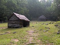
The Jim Bales Place
The first historic stop along the Roaring Fork Motor Nature Trail is the Jim Bales Place, a farm which Jim Bales inherited from his father, Caleb. Jim, born James Wesley Bales in 1869, lived here for much of his life. He married Emma Ogle, a granddaughter of Gilbert Ogle, whose farm was located just above the Bales Place. As Bales got older, the farm passed on to other families, one of which erected a modern frame house on the land (known as the "fancy house") where they entertained visitors.When the Park Service
National Park Service
The National Park Service is the U.S. federal agency that manages all national parks, many national monuments, and other conservation and historical properties with various title designations...
gained control of the land in the 1930s, the frame house was torn down. The Alex Cole Cabin, being more representative of the pioneer days of Appalachia, was moved to the farm from the Sugarlands. Bales' corn crib
Corn crib
A corn crib or corncrib is a type of granary used to dry and store corn. It is also known as a cornhouse or corn house, though this term can refer to any granary....
and barn remain, however.
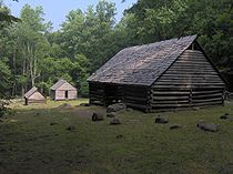
The Ephraim Bales Place
The Bales cabin was a double cabin with a passageway known as a "dog trot" in between. Dog-trot cabins, which are fairly common throughout the southeastern U.S., typically involve two adjacent cabins with roughly 10 feet (3 m) in between, but with one continuous roof. The space between the two halves was relatively cool in summer and warm in winter, making it attractive to dogs. Both halves of the cabin have their own chimney. With the exception of a back porch, the cabin remains largely as it was when the Bales family lived in here in the early 1900s.
Along with the cabin, Bales' corn crib, hog pen, and barn are still standing today, just a few yards from the cabin. A rock wall and paling fence behind the cabin are representative of the two major barriers used in the Northern Smokies in the late 19th and early 20th centuries.
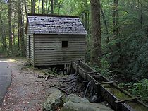
The Alfred Reagan Place
Of all the buildings on Reagan's farm, only his cabin and mill remain today. Due to its sawboard paneling and coat of paint, Reagan's cabin stands out among historical structures in the Smokies today. The cabin's design is known as a "saddlebag" design, which involves two cabins constructed around a single chimney. A kitchen area was added later.
The Reagan mill is a standard tub mill, with a flume redirecting water from Roaring Fork to power a tub-wheel turbine. The turbine turns a grindstone which breaks down corn and wheat into cornmeal and flour. Reagan's mill was well-designed and well-positioned. It is said that when other mills lacked sufficient water power due to low water levels, Reagan's mill would continue to operate.
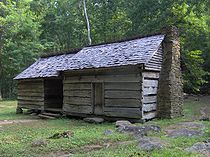
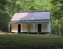
Alex Cole Cabin
The Alex Cole CabinAlex Cole Cabin
The Alex Cole Cabin is a historic house in Sevier County, Tennessee, United States, along Roaring Fork within the Great Smoky Mountains National Park. The last remaining building of the community of Sugarlands community proper, it was built by Albert Alexander "Alex" Cole...
is the last surviving structure from the Sugarlands community proper. Built by mountain guide Albert Alexander Cole, it has been moved from its original site to the Jim Bales Place along the Roaring Fork Motor Nature Trail.
The Roaring Fork Motor Nature Trail
The Roaring Fork Motor Nature Trail is a narrow one-way road that is open to vehicular traffic (cars and small pickup trucks only) in Spring, Summer, and Fall. Along with the historic district, the road passes by two overlooks and a forest that is representative of mid-level elevations in the Smokies.The trail begins just past the Rainbow Falls Trailhead on Cherokee Orchard Road, and slowly ascends Piney Mountain, topping out at an overlook on the mountain's northern slopes (the overlook's elevation is roughly 3,000 feet/914 meters). Just past the overlook, the road passes numerous large chestnut tree
American Chestnut
The American Chestnut is a large, deciduous tree of the beech family native to eastern North America. Before the species was devastated by the chestnut blight, a fungal disease, it was one of the most important forest trees throughout its range...
blowdowns. These trees, which often grew to 5–6 feet in diameter, were killed off by a blight in the 1930s.
As the road descends Piney Mountain, it passes a parking lot at the Trillium Gap Trail
Trillium Gap Trail
The Trillium Gap Trail is an American hiking trail in the Great Smoky Mountains National Park, in Sevier County, Tennessee. The trail ascends Mount Le Conte, the tallest mountain east of the Mississippi River and passes both Grotto Falls and Trillium Gap before reaching the LeConte Lodge,...
head. This hiking trail leads past Grotto Falls and Trillium Gap en route to the summit of Mount Le Conte. Trillium Gap — the gap between Brushy Mountain and the main Le Conte massif — was named by Horace Albright, who observed the trillium
Trillium
Trillium is a genus of about 40–50 species of spring ephemeral perennials, native to temperate regions of North America and Asia....
-filled area in the 1920s.
Past the Trillium Gap Trailhead, the road steadies as it enters the upper reaches of the Roaring Fork hollow. Patches of young tuliptrees mark the former location of the Clabo and Ogle farms. Immediately after the road crosses Roaring Fork, the Jim Bales Place is visible on the right (east). The Grapeyard Ridge Trail, which connects Roaring Fork to Greenbrier, begins just behind the barn. Past the Jim Bales Place are the Ephraim Bales Place and Alfred Reagan Place.
The road continues to descend past the historic district, passing along the way a parking lot that allows for an upclose view of Roaring Fork. A thin waterfall known as "The Place of a Thousand Drips" is the last stop along the motor trail before it re-enters Gatlinburg.
External links
- Great Smoky Mountains National Park Autumn Drives — Contains information on the Roaring Fork Motor Nature Trail
- Great Smoky Mountains National Park Waterfalls — Contains information on Grotto Falls