

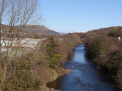
River Tawe
Encyclopedia
South Wales
South Wales is an area of Wales bordered by England and the Bristol Channel to the east and south, and Mid Wales and West Wales to the north and west. The most densely populated region in the south-west of the United Kingdom, it is home to around 2.1 million people and includes the capital city of...
. It flows in a principally south-westerly direction for some 48 km (29.8 mi) from its source below Moel Feity
Glasfynydd Forest
Glasfynydd Forest is an extensive area of coniferous plantations in the west of the Brecon Beacons National Park in south Wales. It straddles the border between the counties of Powys and Carmarthenshire....
in the Old Red Sandstone
Old Red Sandstone
The Old Red Sandstone is a British rock formation of considerable importance to early paleontology. For convenience the short version of the term, 'ORS' is often used in literature on the subject.-Sedimentology:...
hills of the western Brecon Beacons
Brecon Beacons
The Brecon Beacons is a mountain range in South Wales. In a narrow sense, the name refers to the range of popular peaks south of Brecon, including South Wales' highest mountain, Pen y Fan, and which together form the central section of the Brecon Beacons National Park...
to the Bristol Channel
Bristol Channel
The Bristol Channel is a major inlet in the island of Great Britain, separating South Wales from Devon and Somerset in South West England. It extends from the lower estuary of the River Severn to the North Atlantic Ocean...
at Swansea
Swansea
Swansea is a coastal city and county in Wales. Swansea is in the historic county boundaries of Glamorgan. Situated on the sandy South West Wales coast, the county area includes the Gower Peninsula and the Lliw uplands...
. Its main tributaries are the right bank Upper
Upper Clydach River
The Upper Clydach River runs from a poorly drained area south of Cwmgors village and flows south and southeast through Cwm Gors for about 7km to join the River Tawe at Pontardawe - .-External links:*...
and Lower Clydach Rivers and the Afon Twrch
Afon Twrch
The Afon Twrch is a river which rises in the Black Mountain in south Wales. It forms the boundary between the counties of Powys and Carmarthenshire and, downstream of Ystradowen, between Powys and Neath Port Talbot county borough.The headwaters arise on the southern slopes of Bannau Sir Gaer and...
. The Tawe passes through a number of towns and villages including Ystradgynlais
Ystradgynlais
Ystradgynlais is a town on the River Tawe in south west Powys; it is the second largest town in Powys, Wales. The town grew around the iron-making, coal-mining and watch-making industries....
, Ystalyfera
Ystalyfera
Ystalyfera is a former industrial village in the upper Swansea Valley, on the River Tawe, about north-east of Swansea. It is an electoral ward and a community in the unitary authority of Neath Port Talbot, Wales, comprising a resident population of just over 3,000 people, approximately 60% of whom...
, Pontardawe
Pontardawe
Pontardawe is a town of some 5,000 inhabitants in the Swansea Valley in south Wales...
, and Clydach and meets the sea at Swansea Bay
Swansea Bay
Swansea Bay is a bay on the Bristol Channel on the South Wales coast. Places on the bay include Mumbles, Swansea and Port Talbot. The River Neath, River Tawe, River Afan and Blackpill stream flow into the bay....
below Swansea. The Tawe Valley (Cwm Tawe in Welsh
Welsh language
Welsh is a member of the Brythonic branch of the Celtic languages spoken natively in Wales, by some along the Welsh border in England, and in Y Wladfa...
) is more commonly known as the Swansea Valley
Swansea Valley
The Swansea Valley , one of the South Wales Valleys is the name often given to the valley of the River Tawe area in South Wales, UK. It reaches southwest and south from the Brecon Beacons National Park down to the city of Swansea. Today, administration of the area is divided between the City and...
.
The lower part of the valley was intensely industrialised in the 18th and 19th centuries and was especially impacted by metal refining and working and to a much lesser extent by porcelain
Porcelain
Porcelain is a ceramic material made by heating raw materials, generally including clay in the form of kaolin, in a kiln to temperatures between and...
manufacture. Large areas of the lower valley remain contaminated by industrial spoil containing copper
Copper
Copper is a chemical element with the symbol Cu and atomic number 29. It is a ductile metal with very high thermal and electrical conductivity. Pure copper is soft and malleable; an exposed surface has a reddish-orange tarnish...
, lead
Lead
Lead is a main-group element in the carbon group with the symbol Pb and atomic number 82. Lead is a soft, malleable poor metal. It is also counted as one of the heavy metals. Metallic lead has a bluish-white color after being freshly cut, but it soon tarnishes to a dull grayish color when exposed...
, nickel
Nickel
Nickel is a chemical element with the chemical symbol Ni and atomic number 28. It is a silvery-white lustrous metal with a slight golden tinge. Nickel belongs to the transition metals and is hard and ductile...
and zinc
Zinc
Zinc , or spelter , is a metallic chemical element; it has the symbol Zn and atomic number 30. It is the first element in group 12 of the periodic table. Zinc is, in some respects, chemically similar to magnesium, because its ion is of similar size and its only common oxidation state is +2...
. The only significant extant relic of those times is a major nickel refinery at Clydach which is part of the Canadian company Vale Inco. The quality of the river has now greatly improved. Large salmon
Salmon
Salmon is the common name for several species of fish in the family Salmonidae. Several other fish in the same family are called trout; the difference is often said to be that salmon migrate and trout are resident, but this distinction does not strictly hold true...
and trout
Trout
Trout is the name for a number of species of freshwater and saltwater fish belonging to the Salmoninae subfamily of the family Salmonidae. Salmon belong to the same family as trout. Most salmon species spend almost all their lives in salt water...
swim up the river to spawn
Spawn (biology)
Spawn refers to the eggs and sperm released or deposited, usually into water, by aquatic animals. As a verb, spawn refers to the process of releasing the eggs and sperm, also called spawning...
.
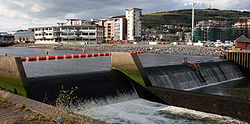
In 1992, a barrage was built at the mouth of the river.
National Cycle Route 43
National Cycle Route 43
National Cycle Network, Route 43 is part of the National Cycle Network and the Celtic Trail, which connects Swansea with Builth Wells. Most of the route is still awaiting development...
follows this river for much of its course.
Bridges and crossings
Bridges over the River Tawe within the City and County of SwanseaSwansea
Swansea is a coastal city and county in Wales. Swansea is in the historic county boundaries of Glamorgan. Situated on the sandy South West Wales coast, the county area includes the Gower Peninsula and the Lliw uplands...
, from north to south:
- A4067A4067 roadThe A4067 road is an A road in Wales connecting Swansea with Sennybridge. It runs in a southwest to northeast direction beginning at Oystermouth Square in Mumbles, Swansea, and continuing from there to Swansea city centre, where there is a break in the route...
(Ffordd Cwm Tawe) road bridge - B4291 road bridge at GlaisGlaisGlais is a small semi-rural village located in Swansea and is host to a site of Special Scientific Interest in the United Kingdom. With a pristine example of glacial moraine in the south of the village's boundaries the location is one of over a thousand sites in Wales that is officially designated...
- A4067 road bridge (second crossing)
- former rail access to the Vale Inco works at Clydach
- disused railway bridge (frmer GWRGreat Western RailwayThe Great Western Railway was a British railway company that linked London with the south-west and west of England and most of Wales. It was founded in 1833, received its enabling Act of Parliament in 1835 and ran its first trains in 1838...
route from Felin Fran to Clydach) - A4067 road bridge (third crossing)
- Park Road bridge at Clydach
- M4 motorwayM4 motorwayThe M4 motorway links London with South Wales. It is part of the unsigned European route E30. Other major places directly accessible from M4 junctions are Reading, Swindon, Bristol, Newport, Cardiff and Swansea...
bridge - railway bridge (Swansea District LineSwansea District LineThe Swansea District Line is a section of line running through the northern part of Swansea, and is used for freight transportation, and minimal passenger transport. It was built by the Great Western Railway in 1912 to provide a faster and less steeply graded route between London and Fishguard, in...
) - Swansea Vale road bridge
- A48 Morriston road bridge - links MorristonMorristonMorriston is a community in the City and County of Swansea, Wales and falls within the Morriston ward. Morriston is sometimes referred to as a distinct town , however Morriston never had a town charter, and is now part of the continuous urban area around Swansea, the centre of which lies three...
town centre to the Swansea Enterprise ParkSwansea Enterprise ParkThe Swansea Enterprise Park is a combined business park, retail park and industrial estate in Swansea, Wales. In 1981 it became the first enterprise zone in the United Kingdom, and the largest. Originally it was named the Swansea Enterprise Zone. The designated area covers parts of the... - Beaufort Bridge - historic access point from Beaufort Road to the now Enterprise Park area.
- Mannesmann pedestrian and cycle bridge - links the Enterprise Park to Beaufort Road in PlasmarlPlasmarlPlasmarl, or Plas-Marl, is a suburban district and historically a village of the City and County of Swansea, Wales. It falls within the old copper quarter of Landore electoral ward.-Location:...
- southern Beaufort Road bridge (unnamed)
- Landore railway viaductLandore viaductThe Landore viaduct is a railway viaduct over the Swansea valley and the River Tawe at Landore in south Wales. It provides a link between Swansea city centre and the West Wales Line to the South Wales Main Line. The valley crossing provides a panoramic view of Landore, Kilvey Hill, the Liberty...
(South Wales Main LineSouth Wales Main LineThe South Wales Main Line , originally known as the London, Bristol and South Wales Direct Railway or simply as the Bristol and South Wales Direct Railway, is a branch of the Great Western Main Line in Great Britain...
) - Morfa footbridge - links the MorfaMorfaMorfa may refer to:* Morfa, Swansea, Wales, United Kingdom* Morfa , a highly potent opiate analgesic drug...
Retail Park to the Liberty StadiumLiberty Stadium, SwanseaThe Liberty Stadium is a purpose-built sports stadium and conferencing venue in the Landore area of Swansea, Wales. The stadium is all-seated, with a capacity of 20,532 making it the largest purpose-built venue in Swansea and the third largest stadium in Wales after the Millennium Stadium and the... - White Rock Bridge - road and pedestrian bridge linking the LandoreLandoreLandore is the name of an electoral ward, a community in the City and County of Swansea, Wales, UK. The community does not have a community council....
district with the Bon-y-maenBon-y-maenBon-y-maen, sometimes spelt Bonymaen, is a community in Swansea, Wales located about north east of Swansea city centre. It falls within the Bonymaen ward. Immediately above Bon-y-maen on the top of Kilvey Hill is the main TV transmitter for Swansea. The local rugby team is Bonymaen RFC....
district - Parc Tawe Bridge - road and pedestrian bridge linking Parc TaweParc TaweParc Tawe is a retail park and leisure area in Swansea, Wales. It is located in the eastern area of the city centre on the west bank of the River Tawe in the Lower Swansea valley....
with St ThomasSt. Thomas, SwanseaSt Thomas is a suburban district and community in Swansea, Wales. It is a mainly residential area which lies east of Swansea city centre across the River Tawe and falls within the St Thomas ward. The southern boundary is formed by the Fabian Way... - Quay Parade Bridge - road and pedestrian bridge linking Quay Parade with Fabian Way
- Old Swansea Bridge - a former railway bridge: the bridge deck no longer exists but the piers remain
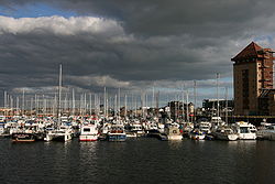
- Sail Bridge - a pedestrian and cycle bridge linking the Maritime QuarterMaritime QuarterThe Maritime Quarter, or Swansea Marina, is a residential area of Swansea, Wales, UK located immediately south of the city centre shopping core. It falls within Swansea's Castle ward...
near Sainsbury's superstore to the SA1 Swansea WaterfrontSA1 Swansea WaterfrontSA1 Swansea Waterfront is the marketing name given to the brownfield development area located in northern part of Swansea Docks. The area is located directly to the southeast of Swansea city centre. It is bordered by the Fabian Way to the north and covers the Prince of Wales Dock area.The...
development area - Trafalgar Bridge - a pedestrian and cycle bridge located near the Swansea barrageSwansea barrageThe Swansea barrage was completed in 1992 creating a new marina at the mouth of the River Tawe extending the leisure boat facilities already being offered by the old South Dock....
: built at a cost of £1.2 million, it crosses the barrage lock and part of the bridge swings with the lock gates
Future developments
There are plans for further housing developments on both east and west banks of the River Tawe and a proposal to operate river taxis along the river.See also
- Lower Swansea valleyLower Swansea valleyThe Lower Swansea valley is the lower half of the valley of the River Tawe in south Wales. It runs from approximately the level of Clydach down to Swansea docks, where it opens into Swansea Bay and the Bristol Channel...
- Swansea Bay barrage
- Swansea University Rowing ClubSwansea University Rowing ClubThe Swansea University Rowing Club is the rowing club of Swansea University, Wales, and is situated on the west bank of the River Tawe in Swansea...
, who train on the river.