

River Tame, West Midlands
Encyclopedia
The River Tame is the main river of the West Midlands, and the most important tributary of the River Trent
. The Tame is about 40 km from source at Oldbury
to its confluence with the Trent near Alrewas
, but the main river length of the entire catchment, i.e. the Tame and its main tributaries, is about 285 km.
, and it is likely that the River Thame
, the River Thames
, the River Teme
, the River Team
, and the River Tamar
all share the derivation.
or Tomsæte' ("Tame-dwellers"), an Anglian
tribe living in the valley of the Tame at the time of the Roman occupation
and around Tamworth
during the Kingdom of Mercia
. They migrated up the valleys of the Trent and Tame from the Humber Estuary and later formed Mercia.
 The Tame is generally considered to have two main sources; Willenhall
and Oldbury, West Midlands
. The tributaries arising in these locations are generally known as the Willenhall arm and the Oldbury arm of the Tame. However, some of its tributary streams rise as far to the west and north as Bilston
and Wednesfield
in the city of Wolverhampton
. Much of the course of the river has been modified over the centuries and the urban sections now run mainly through culverts or canalised channels. Both arms of the Tame flow through the Black Country
to their confluence at Bescot
, on the edge of Walsall.
, near Willenhall. However the SMURF project traces it back as far as Stow Heath, Bilston
, where it is marked by a marshy patch at the northern end of the City of Wolverhampton College
Wellington Road campus; hence, SMURF uses the term "Wolverhampton arm" for this section of the Tame. Victorian Ordnance Survey maps actually trace the sources of the Tame further back, to the site of the old Stow Heath colliery, which is now Wolverhampton's East Park.
The stream runs invisibly but generally north-east through Stowlawn, and then cuts across the southern edge of Willenhall
, appearing briefly among the warehouses, and picking up reinforcement from the Waddens Brook, which originates in Wednesfield. It appears definitively at Bentley, whence it runs south through the industrial part of Bentley, before turning south-east, following a realigned course alongside and beneath the M6 motorway
, to Bescot.
, between Whiteheath and Langley Green
. It winds its way up through Langley and around the southern and eastern edges of Oldbury town centre, surfacing due south of Sandwell and Dudley railway station
, from which point it remains mainly on the surface and is easily traced. Bearing generally north-west, it skirts Brades Village
and passes through Sheepwash Urban Park
and Horseley Heath
to the centre of Great Bridge
. It then zig-zags across the southern and eastern parts of Wednesbury
, to meet the Willenhall or Wolverhampton arm at Bescot
.
and its interchange with the M5
, through Sandwell Valley
and into north Birmingham
. It passes through Hamstead
to Perry Barr
, through Witton
and beneath Gravelly Hill Interchange
(where it is fed by the Rea
) to Washwood Heath
.
Skirting to the north of Castle Bromwich
, it leaves Birmingham to the north east, passing Water Orton
in Warwickshire
. At Hams Hall
, immediately after its confluence with the River Blythe
and the little River Bourne, it turns sharply to take up a northward course, and soon feeds into the large complex of water purification lakes at Lea Marston
that now make up Kingsbury Water Park
. It then crosses into Staffordshire
flowing through Middleton Lakes RSPB reserve
in a wide valley between Drayton Bassett
to the west and Dosthill
to the east. It then flows under Watling Street
to the east of Fazeley
and under an aqueduct
(photo) carrying the Coventry Canal
. It continues northwards to Tamworth
, which takes its name from the river, where it is joined by the River Anker
immediately to the east of Lady Bridge beneath the strategically positioned Tamworth Castle
. The river continues its generally northward route past Hopwas
, Comberford
and Elford
until it arrives at the National Memorial Arboretum
where it forms the boundary between this and the Croxall Lakes
Nature Reserve. After this it flows under the railway at Wichnor Viaduct to its confluence with the Trent
near Alrewas
. The eventual outflow is into the North Sea
, via the Humber Estuary
.
It is interesting to note, from both maps and aerial photography, that when the Tame and Trent
meet, the Tame is the bigger river, the Trent effectively joining it as a tributary. However, the Trent being the longer river at that point is considered the more senior and so the combined river bears its name.
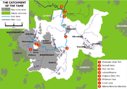
The catchment of the Tame covers an area of nearly 1500 km² and contains a population of about 1.7 million people. Approximately 42% of the Tame basin is urbanised, making it the most heavily-urbanised river basin in the United Kingdom.
The traditional industries of Birmingham and the Black Country, based on coal, iron and steel, were heavily polluting, and the Tame is conducted through a series of purification lakes below Lea Marston
, in Warwickshire, to remove pollutants, an arrangement unique in the UK. A large part of this lake area forms the Kingsbury Water Park
. Clean-up operations in a notoriously polluted stretch of the river in the Witton
area of Birmingham have meant that aquatic wildfowl such as ducks and swans have settled on that stretch of the river. Sandwell Valley has evolved over the last two decades into an important urban wildlife habitat.
The Tame is non-navigable
throughout its course.
.
The river is susceptible to spectacular flooding at the village of Hopwas
between Tamworth and Lichfield
during periods of heavy autumnal rain. The long-term persistence of the problem is attested by the Anglo-Saxon meaning of the village's name:- hop - nook of land, was - watery. There is also a substantial bend in the course of the river between Hopwas and Elford, giving rise to the name Tamhorn for the area.
 Flood prevention work was carried out on Sandwell Valley
in the 1980s. Forge Mill Lake was created as a stormwater retention basin by enlarging an existing depression. The river was dredged to deepen it and the gravel used to construct an island in the lake. This evolved into part of a nature reserve, at present leased to the Royal Society for the Protection of Birds
. At about the same time,a similar arrangement was constructed at Sheepwash Urban Park
, utilising old brickworks excavations as a storm water basin to relieve flooding by the Oldbury Arm.
In 2005, the river's alignment through Perry Hall Park
in Perry Barr
, Birmingham, just downstream of Sandwell Valley, was remodelled to slow the flow, alleviate flooding and create improved habitat
s for wildlife
, as part of the SMURF (Sustainable Management of Urban Rivers and Floodplains) project.
Nonetheless, in June 2007, after heavy rain, the river burst its banks in the Witton
area of Birmingham (just downstream of Perry Barr) and at Kingsbury Water Park
.
In 2009, the Environment Agency
held a public consultation on its proposed flood alleviation measures. Subsequently, the Environment Agency undertook £380,000-worth of improvements, mainly involving dredging and clearing of obstacles. 1000 tonnes of gravel were removed from around the Chester Road Bridge at Castle Vale and deposited further downstream to improve the fish spawning habitat. The Gravelly Hill section was relieved of 900 tonnes of silt and debris. The Oldbury Arm was cleared of debris and five weirs were removed from it to facilitate fish migration. Work under this programme continues into 2011, mainly around Water Orton.
River Trent
The River Trent is one of the major rivers of England. Its source is in Staffordshire on the southern edge of Biddulph Moor. It flows through the Midlands until it joins the River Ouse at Trent Falls to form the Humber Estuary, which empties into the North Sea below Hull and Immingham.The Trent...
. The Tame is about 40 km from source at Oldbury
Oldbury, West Midlands
Oldbury is a town in the West Midlands in England. It is a part of the Black Country and the administrative centre of the borough of Sandwell.-Local government:...
to its confluence with the Trent near Alrewas
Alrewas
Alrewas is a large village and civil parish within Lichfield District, in Staffordshire, England. It lies on the A38 road, approximately 5 miles north of Lichfield...
, but the main river length of the entire catchment, i.e. the Tame and its main tributaries, is about 285 km.
Etymology
The name derives from the Celtic language, although it may have even earlier roots. It is usually thought to mean "dark", by analogy with the Sanskrit word tamas, meaning darkness. Other possibilities are "slow moving", or "flowing" although the precise meaning is uncertain. The name is shared with the River Tame, Greater ManchesterRiver Tame, Greater Manchester
The River Tame flows through Greater Manchester, England.-Source:The Tame rises on Denshaw Moor in Greater Manchester, close to the border with West Yorkshire but within the historic West Riding of Yorkshire.-Course:...
, and it is likely that the River Thame
River Thame
The River Thame is a river in Southern England. It is a tributary of the larger and better-known River Thames.The general course of the River Thame is north-east to south-west and the distance from its source to the River Thames is about 40 miles...
, the River Thames
River Thames
The River Thames flows through southern England. It is the longest river entirely in England and the second longest in the United Kingdom. While it is best known because its lower reaches flow through central London, the river flows alongside several other towns and cities, including Oxford,...
, the River Teme
River Teme
The River Teme rises in Mid Wales, south of Newtown in Powys, and flows through Knighton where it crosses the border into England down to Ludlow in Shropshire, then to the north of Tenbury Wells on the Shropshire/Worcestershire border there, on its way to join the River Severn south of Worcester...
, the River Team
River Team
The River Team is a tributary of the River Tyne in Gateshead, England.Its source is near Annfield Plain, where it is known as Kyo Burn. Then changing its name again to Causey Burn as it flows underneath the famous Causey Arch. It then flows past Beamish Museum in County Durham then crosses the...
, and the River Tamar
River Tamar
The Tamar is a river in South West England, that forms most of the border between Devon and Cornwall . It is one of several British rivers whose ancient name is assumed to be derived from a prehistoric river word apparently meaning "dark flowing" and which it shares with the River Thames.The...
all share the derivation.
Historic significance
Birmingham and the parishes in the centre and north of the modern conurbation were probably colonised by the TomsaeteTomsaete
The Tomsaete or Tomsæte were a tribe or clan in Anglo-Saxon England living in the valley of the River Tame in the West Midlands of England from around 500 and remaining around Tamworth throughout the existence of the Kingdom of Mercia.An Anglo-Saxon charter of 849 describes an area of Cofton...
or Tomsæte' ("Tame-dwellers"), an Anglian
Anglian
Anglian may refer to* The Anglian dialects* The Anglic languages* The Anglian Stage * The Anglian automobile* Used in reference to the cultural products and politics of the Angles of Anglo-Saxon England...
tribe living in the valley of the Tame at the time of the Roman occupation
Roman conquest of Britain
The Roman conquest of Britain was a gradual process, beginning effectively in AD 43 under Emperor Claudius, whose general Aulus Plautius served as first governor of Britannia. Great Britain had already frequently been the target of invasions, planned and actual, by forces of the Roman Republic and...
and around Tamworth
Tamworth
Tamworth is a town and local government district in Staffordshire, England, located north-east of Birmingham city centre and north-west of London. The town takes its name from the River Tame, which flows through the town, as does the River Anker...
during the Kingdom of Mercia
Mercia
Mercia was one of the kingdoms of the Anglo-Saxon Heptarchy. It was centred on the valley of the River Trent and its tributaries in the region now known as the English Midlands...
. They migrated up the valleys of the Trent and Tame from the Humber Estuary and later formed Mercia.
Course and catchment
Willenhall
Willenhall is a town in the Black Country area of the West Midlands of England, with a population of approximately 40,000. It is situated between Wolverhampton and Walsall, historically in the county of Staffordshire...
and Oldbury, West Midlands
Oldbury, West Midlands
Oldbury is a town in the West Midlands in England. It is a part of the Black Country and the administrative centre of the borough of Sandwell.-Local government:...
. The tributaries arising in these locations are generally known as the Willenhall arm and the Oldbury arm of the Tame. However, some of its tributary streams rise as far to the west and north as Bilston
Bilston
Bilston is a town in the English county of West Midlands, situated in the southeastern corner of the City of Wolverhampton. Three wards of Wolverhampton City Council cover the town: Bilston East and Bilston North, which almost entirely comprise parts of the historic Borough of Bilston, and...
and Wednesfield
Wednesfield
Wednesfield lies at , and is located to the northeast of Wolverhampton city centre on the northern fringe of the West Midlands conurbation...
in the city of Wolverhampton
Wolverhampton
Wolverhampton is a city and metropolitan borough in the West Midlands, England. For Eurostat purposes Walsall and Wolverhampton is a NUTS 3 region and is one of five boroughs or unitary districts that comprise the "West Midlands" NUTS 2 region...
. Much of the course of the river has been modified over the centuries and the urban sections now run mainly through culverts or canalised channels. Both arms of the Tame flow through the Black Country
Black Country
The Black Country is a loosely defined area of the English West Midlands conurbation, to the north and west of Birmingham, and to the south and east of Wolverhampton. During the industrial revolution in the 19th century this area had become one of the most intensely industrialised in the nation...
to their confluence at Bescot
Bescot
Bescot is an area of Walsall in the West Midlands of England.It is served by Bescot Stadium railway station, adjacent to which is Bescot depot where locomotives are maintained. The Bescot Stadium was built in 1990 for Walsall F.C.....
, on the edge of Walsall.
The Willenhall or Wolverhampton Arm
The northern arm is easily traced from BentleyBentley, West Midlands
Bentley is an area in the Metropolitan Borough of Walsall located around Junction 10 of the M6 Motorway. It shares borders with the areas of Willenhall, Beechdale, Ashmore Park, Pleck, Darlaston and Alumwell.- History :...
, near Willenhall. However the SMURF project traces it back as far as Stow Heath, Bilston
Bilston
Bilston is a town in the English county of West Midlands, situated in the southeastern corner of the City of Wolverhampton. Three wards of Wolverhampton City Council cover the town: Bilston East and Bilston North, which almost entirely comprise parts of the historic Borough of Bilston, and...
, where it is marked by a marshy patch at the northern end of the City of Wolverhampton College
City of Wolverhampton College
City of Wolverhampton College is a further education college located in Wolverhampton, West Midlands, England.It was formed in September 1999 as the result of a merger of Wulfrun College in Wolverhampton and Bilston Community College in Bilston....
Wellington Road campus; hence, SMURF uses the term "Wolverhampton arm" for this section of the Tame. Victorian Ordnance Survey maps actually trace the sources of the Tame further back, to the site of the old Stow Heath colliery, which is now Wolverhampton's East Park.
The stream runs invisibly but generally north-east through Stowlawn, and then cuts across the southern edge of Willenhall
Willenhall
Willenhall is a town in the Black Country area of the West Midlands of England, with a population of approximately 40,000. It is situated between Wolverhampton and Walsall, historically in the county of Staffordshire...
, appearing briefly among the warehouses, and picking up reinforcement from the Waddens Brook, which originates in Wednesfield. It appears definitively at Bentley, whence it runs south through the industrial part of Bentley, before turning south-east, following a realigned course alongside and beneath the M6 motorway
M6 motorway
The M6 motorway runs from junction 19 of the M1 at the Catthorpe Interchange, near Rugby via Birmingham then heads north, passing Stoke-on-Trent, Manchester, Preston, Carlisle and terminating at the Gretna junction . Here, just short of the Scottish border it becomes the A74 which continues to...
, to Bescot.
The Oldbury Arm
The southern arm appears prominently close to Oldbury town centre, which gives it its name, but can be traced back to an industrial area at Titford, just west of the M5 motorwayM5 motorway
The M5 is a motorway in England. It runs from a junction with the M6 at West Bromwich near Birmingham to Exeter in Devon. Heading south-west, the M5 runs east of West Bromwich and west of Birmingham through Sandwell Valley...
, between Whiteheath and Langley Green
Langley Green, West Midlands
Langley Green is a suburb of Birmingham, on the B4169 road, in the Sandwell District, in the English county of West Midlands. Langley Green has a library and a railway station called Langley Green railway station.- References :*A-Z Birmingham...
. It winds its way up through Langley and around the southern and eastern edges of Oldbury town centre, surfacing due south of Sandwell and Dudley railway station
Sandwell and Dudley railway station
Sandwell and Dudley railway station is on the Stour Valley Section of the West Coast Main Line, on the outskirts of Oldbury town centre on Bromford Lane , England....
, from which point it remains mainly on the surface and is easily traced. Bearing generally north-west, it skirts Brades Village
Brades Village
Brades Village is an area of Oldbury, West Midlands, England....
and passes through Sheepwash Urban Park
Sheepwash Urban Park
Sheepwash Urban Park is a Local Nature Reserve , situated in Sandwell Metropolitan Borough, in the West Midlands conurbation of the United Kingdom. It forms part of the Black Country Urban Forest.- Location :...
and Horseley Heath
Horseley Heath
Horseley Heath is a residential area of Tipton, in the West Midlands of England. It is situated around the main A461 road which links the major townships of Dudley and Walsall, and stands on the banks of the River Tame....
to the centre of Great Bridge
Great Bridge
Great Bridge may refer to:* Great Bridge, Virginia, a community in Chesapeake, Virginia, USA.* Battle of Great Bridge, revolutionary war battle in Virginia* Great Bridge, West Midlands, a town in Sandwell, West Midlands, England....
. It then zig-zags across the southern and eastern parts of Wednesbury
Wednesbury
Wednesbury is a market town in England's Black Country, part of the Sandwell metropolitan borough in West Midlands, near the source of the River Tame. Similarly to the word Wednesday, it is pronounced .-Pre-Medieval and Medieval times:...
, to meet the Willenhall or Wolverhampton arm at Bescot
Bescot
Bescot is an area of Walsall in the West Midlands of England.It is served by Bescot Stadium railway station, adjacent to which is Bescot depot where locomotives are maintained. The Bescot Stadium was built in 1990 for Walsall F.C.....
.
The Main Stream
The unified Tame then flows, partly through channels realigned to make way for the M6 motorwayM6 motorway
The M6 motorway runs from junction 19 of the M1 at the Catthorpe Interchange, near Rugby via Birmingham then heads north, passing Stoke-on-Trent, Manchester, Preston, Carlisle and terminating at the Gretna junction . Here, just short of the Scottish border it becomes the A74 which continues to...
and its interchange with the M5
M5 motorway
The M5 is a motorway in England. It runs from a junction with the M6 at West Bromwich near Birmingham to Exeter in Devon. Heading south-west, the M5 runs east of West Bromwich and west of Birmingham through Sandwell Valley...
, through Sandwell Valley
Sandwell Valley
Sandwell Valley is an area of green belt in the West Midlands of England, on the border of Birmingham and West Bromwich, with Walsall at its northern end....
and into north Birmingham
Birmingham
Birmingham is a city and metropolitan borough in the West Midlands of England. It is the most populous British city outside the capital London, with a population of 1,036,900 , and lies at the heart of the West Midlands conurbation, the second most populous urban area in the United Kingdom with a...
. It passes through Hamstead
Hamstead, West Midlands
Hamstead is an area of Birmingham, England, between Handsworth Wood and Great Barr, and adjacent to the Sandwell Valley area of West Bromwich. Historically it has its foundations as part of the Hamstead Colliery from the early to mid 20th Century with a lot of the housing have been built for the...
to Perry Barr
Perry Barr
Perry Barr is an inner-city area in north Birmingham, England. It is also a council constituency, managed by its own district committee. The constituency includes the smaller Perry Barr ward and the wards of Handsworth Wood, Lozells and East Handsworth, and Oscott, which elect three councillors to...
, through Witton
Witton
Witton may refer to one of several places in England:*Witton-le-Wear, County Durham*Witton, Lancashire, a former parish in Blackburn*Postwick with Witton, in the county of Norfolk and 5 miles east of Norwich, in Broadland district...
and beneath Gravelly Hill Interchange
Gravelly Hill Interchange
Gravelly Hill Interchange, better known by its nickname Spaghetti Junction, is junction 6 of the M6 motorway where it meets the A38 Aston Expressway in Birmingham, England.- Overview :...
(where it is fed by the Rea
River Rea
The River Rea is a small river which passes through Birmingham, England. The name of the river derives from a root found in many Indo-European languages and means "to run" or "to flow". It frequently bursts its banks after heavy rain....
) to Washwood Heath
Washwood Heath
Washwood Heath is a ward in Birmingham, within the formal district of Hodge Hill, roughly two miles north-east of Birmingham city centre, England...
.
Skirting to the north of Castle Bromwich
Castle Bromwich
Castle Bromwich is a suburb situated within the northern part of the Metropolitan Borough of Solihull in the English county of West Midlands. It is bordered by the rest of the borough to the south east, North Warwickshire to the east and north east; also Shard End to the south west, Castle Vale,...
, it leaves Birmingham to the north east, passing Water Orton
Water Orton
Water Orton is a village near the River Tame in the North Warwickshire borough of Warwickshire in England. It is located between Castle Bromwich and Coleshill, and borders the West Midlands metropolitan county boundary to the north, west and south. At the last census in 2001, the population was...
in Warwickshire
Warwickshire
Warwickshire is a landlocked non-metropolitan county in the West Midlands region of England. The county town is Warwick, although the largest town is Nuneaton. The county is famous for being the birthplace of William Shakespeare...
. At Hams Hall
Hams Hall
Hams Hall is a place near Lea Marston in North Warwickshire, England, named after the manor house which formerly stood there.-Hams Hall Rail Freight Terminal:http://www.hamshallrailterminal.co.uk...
, immediately after its confluence with the River Blythe
River Blythe
The Blythe is a river in the English Midlands which runs from Warwickshire, through the borough of Solihull and on to Coleshill. It runs along the Meriden Gap in the Midlands Plateau,...
and the little River Bourne, it turns sharply to take up a northward course, and soon feeds into the large complex of water purification lakes at Lea Marston
Lea Marston
Lea Marston is a village and civil parish on the River Tame in Warwickshire, England, about south-west of Atherstone. Lea Marston is close to the county boundary with Birmingham and about east of Sutton Coldfield.-Manor:...
that now make up Kingsbury Water Park
Kingsbury Water Park
Kingsbury Water Park is a country park in north Warwickshire, England, not far from Birmingham and lying on the River Tame. It is owned and managed by Warwickshire County Council. It has fifteen lakes situated in over 600 acres of country park. It is renowned for its birdlife, and is popular with...
. It then crosses into Staffordshire
Staffordshire
Staffordshire is a landlocked county in the West Midlands region of England. For Eurostat purposes, the county is a NUTS 3 region and is one of four counties or unitary districts that comprise the "Shropshire and Staffordshire" NUTS 2 region. Part of the National Forest lies within its borders...
flowing through Middleton Lakes RSPB reserve
Middleton Lakes RSPB reserve
Middleton Lakes RSPB reserve is a nature reserve, formally opened on 19 May 2011, created and run by the Royal Society for the Protection of Birds at Middleton, Warwickshire, England, just south of Tamworth...
in a wide valley between Drayton Bassett
Drayton Bassett
Drayton Bassett is a village and civil parish in the District of Lichfield, Staffordshire, England. Nearby are the town of Tamworth and Middleton Lakes RSPB reserve, formerly a gravel quarry known in part as Drayton Bassett Pits.It formerly had a manor....
to the west and Dosthill
Dosthill
Dosthill is an area of Tamworth, Staffordshire, 2.5 miles south of the town centre, and close to the River Tame. The area is mostly residential, centring around Dosthill High Street, with local employment on the adjoining Tame Valley Industrial Estate...
to the east. It then flows under Watling Street
Watling Street
Watling Street is the name given to an ancient trackway in England and Wales that was first used by the Britons mainly between the modern cities of Canterbury and St Albans. The Romans later paved the route, part of which is identified on the Antonine Itinerary as Iter III: "Item a Londinio ad...
to the east of Fazeley
Fazeley
Fazeley is a small town and civil parish in the District of Lichfield, Staffordshire, England. Fazeley is located on the outskirts of Tamworth and the civil parish of Fazeley also includes Mile Oak and Bonehill....
and under an aqueduct
Aqueduct
An aqueduct is a water supply or navigable channel constructed to convey water. In modern engineering, the term is used for any system of pipes, ditches, canals, tunnels, and other structures used for this purpose....
(photo) carrying the Coventry Canal
Coventry Canal
The Coventry Canal is a navigable narrow canal in the Midlands of England.It starts in Coventry and ends 38 miles north at Fradley Junction, just north of Lichfield, where it joins the Trent and Mersey Canal...
. It continues northwards to Tamworth
Tamworth
Tamworth is a town and local government district in Staffordshire, England, located north-east of Birmingham city centre and north-west of London. The town takes its name from the River Tame, which flows through the town, as does the River Anker...
, which takes its name from the river, where it is joined by the River Anker
River Anker
The River Anker is a river in England. The river flows through the centre of Nuneaton towards Tamworth in Staffordshire. The river continues on before merging with the River Tame in Tamworth...
immediately to the east of Lady Bridge beneath the strategically positioned Tamworth Castle
Tamworth Castle
Tamworth Castle, a Grade I listed building, is a Norman castle, located next to the River Tame, in the town of Tamworth in Staffordshire, England....
. The river continues its generally northward route past Hopwas
Hopwas
Hopwas is a village in Staffordshire, England. It lies just over west of Tamworth and east of Lichfield. It is situated where the A51 road crosses both the River Tame and the Coventry Canal...
, Comberford
Comberford
Comberford is a small settlement in Staffordshire, England. It lies by the River Tame, about north-east of Tamworth along the A513 road. Historically part of the parish of Wigginton, it is now within the Wigginton and Hopwas civil parish in the district of Lichfield.There is an Anglican church in...
and Elford
Elford
Elford is a village and civil parish in Lichfield District, Staffordshire, England. It is situated on the east bank of the River Tame, about east of the City of Lichfield and 5 miles north of Tamworth.-Origins:...
until it arrives at the National Memorial Arboretum
National Memorial Arboretum
The National Memorial Arboretum is a national site of remembrance at Alrewas, near Lichfield, Staffordshire, England. It gives its purpose as:-Origins:...
where it forms the boundary between this and the Croxall Lakes
Croxall Lakes
Croxall Lakes is a nature reserve located between the villages of Croxall and Alrewas, Staffordshire, in the United Kingdom. The nature reserve comprises two lakes and grassland between them. The lakes were formed through the quarrying of sand and gravel deposits, these excavations subsequently...
Nature Reserve. After this it flows under the railway at Wichnor Viaduct to its confluence with the Trent
River Trent
The River Trent is one of the major rivers of England. Its source is in Staffordshire on the southern edge of Biddulph Moor. It flows through the Midlands until it joins the River Ouse at Trent Falls to form the Humber Estuary, which empties into the North Sea below Hull and Immingham.The Trent...
near Alrewas
Alrewas
Alrewas is a large village and civil parish within Lichfield District, in Staffordshire, England. It lies on the A38 road, approximately 5 miles north of Lichfield...
. The eventual outflow is into the North Sea
North Sea
In the southwest, beyond the Straits of Dover, the North Sea becomes the English Channel connecting to the Atlantic Ocean. In the east, it connects to the Baltic Sea via the Skagerrak and Kattegat, narrow straits that separate Denmark from Norway and Sweden respectively...
, via the Humber Estuary
Humber
The Humber is a large tidal estuary on the east coast of Northern England. It is formed at Trent Falls, Faxfleet, by the confluence of the tidal River Ouse and the tidal River Trent. From here to the North Sea, it forms part of the boundary between the East Riding of Yorkshire on the north bank...
.
It is interesting to note, from both maps and aerial photography, that when the Tame and Trent
River Trent
The River Trent is one of the major rivers of England. Its source is in Staffordshire on the southern edge of Biddulph Moor. It flows through the Midlands until it joins the River Ouse at Trent Falls to form the Humber Estuary, which empties into the North Sea below Hull and Immingham.The Trent...
meet, the Tame is the bigger river, the Trent effectively joining it as a tributary. However, the Trent being the longer river at that point is considered the more senior and so the combined river bears its name.
The catchment of the Tame covers an area of nearly 1500 km² and contains a population of about 1.7 million people. Approximately 42% of the Tame basin is urbanised, making it the most heavily-urbanised river basin in the United Kingdom.
The traditional industries of Birmingham and the Black Country, based on coal, iron and steel, were heavily polluting, and the Tame is conducted through a series of purification lakes below Lea Marston
Lea Marston
Lea Marston is a village and civil parish on the River Tame in Warwickshire, England, about south-west of Atherstone. Lea Marston is close to the county boundary with Birmingham and about east of Sutton Coldfield.-Manor:...
, in Warwickshire, to remove pollutants, an arrangement unique in the UK. A large part of this lake area forms the Kingsbury Water Park
Kingsbury Water Park
Kingsbury Water Park is a country park in north Warwickshire, England, not far from Birmingham and lying on the River Tame. It is owned and managed by Warwickshire County Council. It has fifteen lakes situated in over 600 acres of country park. It is renowned for its birdlife, and is popular with...
. Clean-up operations in a notoriously polluted stretch of the river in the Witton
Witton, West Midlands
Witton is an inner city area in Birmingham, England, in the metropolitan county of the West Midlands. It was within the ancient parish of Aston in the Hemlingford hundred of the historic county of Warwickshire...
area of Birmingham have meant that aquatic wildfowl such as ducks and swans have settled on that stretch of the river. Sandwell Valley has evolved over the last two decades into an important urban wildlife habitat.
The Tame is non-navigable
Navigability
A body of water, such as a river, canal or lake, is navigable if it is deep, wide and slow enough for a vessel to pass. Preferably there are few obstructions such as rocks or trees to avoid. Bridges must have sufficient clearance. High water speed may make a channel unnavigable. Waters may be...
throughout its course.
Pollution
The Tame was once one of Britain's dirtiest rivers. It is now much cleaner, due to changes in legislation and the use of purification lakes at Lea MarstonLea Marston
Lea Marston is a village and civil parish on the River Tame in Warwickshire, England, about south-west of Atherstone. Lea Marston is close to the county boundary with Birmingham and about east of Sutton Coldfield.-Manor:...
.
Flooding
There have been major flooding problems associated with the river. These result largely from the mainly urban character of the upper catchment. Rainfall runs off the roofs and hard surfaces, raising river levels very rapidly. Rapid house-building and commercial development may have exacerbated the problem in recent years. Another development contributing to worse flooding has been the general rise in groundwater levels in the upper catchment area. As traditional industries have declined and been replaced by light industries and services, far less water has been taken from the river and the underlying aquifer.The river is susceptible to spectacular flooding at the village of Hopwas
Hopwas
Hopwas is a village in Staffordshire, England. It lies just over west of Tamworth and east of Lichfield. It is situated where the A51 road crosses both the River Tame and the Coventry Canal...
between Tamworth and Lichfield
Lichfield
Lichfield is a cathedral city, civil parish and district in Staffordshire, England. One of eight civil parishes with city status in England, Lichfield is situated roughly north of Birmingham...
during periods of heavy autumnal rain. The long-term persistence of the problem is attested by the Anglo-Saxon meaning of the village's name:- hop - nook of land, was - watery. There is also a substantial bend in the course of the river between Hopwas and Elford, giving rise to the name Tamhorn for the area.
Flood prevention
Sandwell Valley
Sandwell Valley is an area of green belt in the West Midlands of England, on the border of Birmingham and West Bromwich, with Walsall at its northern end....
in the 1980s. Forge Mill Lake was created as a stormwater retention basin by enlarging an existing depression. The river was dredged to deepen it and the gravel used to construct an island in the lake. This evolved into part of a nature reserve, at present leased to the Royal Society for the Protection of Birds
Royal Society for the Protection of Birds
Bird Notes and News was first published in April 1903.The title changed to 'Bird Notes' in 1947. In the 1950s, there were four copies per year . Each volume covered two years, spread over three calendar years...
. At about the same time,a similar arrangement was constructed at Sheepwash Urban Park
Sheepwash Urban Park
Sheepwash Urban Park is a Local Nature Reserve , situated in Sandwell Metropolitan Borough, in the West Midlands conurbation of the United Kingdom. It forms part of the Black Country Urban Forest.- Location :...
, utilising old brickworks excavations as a storm water basin to relieve flooding by the Oldbury Arm.
In 2005, the river's alignment through Perry Hall Park
Perry Hall Park
Perry Hall Park is a park in Perry Barr, Birmingham, England, at . It was in Staffordshire until 1924....
in Perry Barr
Perry Barr
Perry Barr is an inner-city area in north Birmingham, England. It is also a council constituency, managed by its own district committee. The constituency includes the smaller Perry Barr ward and the wards of Handsworth Wood, Lozells and East Handsworth, and Oscott, which elect three councillors to...
, Birmingham, just downstream of Sandwell Valley, was remodelled to slow the flow, alleviate flooding and create improved habitat
Habitat (ecology)
A habitat is an ecological or environmental area that is inhabited by a particular species of animal, plant or other type of organism...
s for wildlife
Wildlife
Wildlife includes all non-domesticated plants, animals and other organisms. Domesticating wild plant and animal species for human benefit has occurred many times all over the planet, and has a major impact on the environment, both positive and negative....
, as part of the SMURF (Sustainable Management of Urban Rivers and Floodplains) project.
Nonetheless, in June 2007, after heavy rain, the river burst its banks in the Witton
Witton, West Midlands
Witton is an inner city area in Birmingham, England, in the metropolitan county of the West Midlands. It was within the ancient parish of Aston in the Hemlingford hundred of the historic county of Warwickshire...
area of Birmingham (just downstream of Perry Barr) and at Kingsbury Water Park
Kingsbury Water Park
Kingsbury Water Park is a country park in north Warwickshire, England, not far from Birmingham and lying on the River Tame. It is owned and managed by Warwickshire County Council. It has fifteen lakes situated in over 600 acres of country park. It is renowned for its birdlife, and is popular with...
.
In 2009, the Environment Agency
Environment Agency
The Environment Agency is a British non-departmental public body of the Department for Environment, Food and Rural Affairs and an Assembly Government Sponsored Body of the Welsh Assembly Government that serves England and Wales.-Purpose:...
held a public consultation on its proposed flood alleviation measures. Subsequently, the Environment Agency undertook £380,000-worth of improvements, mainly involving dredging and clearing of obstacles. 1000 tonnes of gravel were removed from around the Chester Road Bridge at Castle Vale and deposited further downstream to improve the fish spawning habitat. The Gravelly Hill section was relieved of 900 tonnes of silt and debris. The Oldbury Arm was cleared of debris and five weirs were removed from it to facilitate fish migration. Work under this programme continues into 2011, mainly around Water Orton.
Features
| Point | Coordinates Geographic coordinate system A geographic coordinate system is a coordinate system that enables every location on the Earth to be specified by a set of numbers. The coordinates are often chosen such that one of the numbers represent vertical position, and two or three of the numbers represent horizontal position... (links to map & photo sources) |
|---|---|
| Sheepwash Urban Park Sheepwash Urban Park Sheepwash Urban Park is a Local Nature Reserve , situated in Sandwell Metropolitan Borough, in the West Midlands conurbation of the United Kingdom. It forms part of the Black Country Urban Forest.- Location :... |
52.5227°N 2.0395°W |
| Confluence of Oldbury & Wednesbury branches | 52.56378°N 1.992°W |
| Tame Valley Canal Tame Valley Canal The Tame Valley Canal is a relatively late canal in the West Midlands of England. It forms part of the Birmingham Canal Navigations. It takes its name from the roughly-parallel River Tame.-Geography:... |
52.5513°N 1.9661°W |
| Forge Mill Lake inlet | 52.531906°N 1.957956°W |
| Forge Mill Lake outlet, RSPB Sandwell Valley RSPB Sandwell Valley Sandwell Valley RSPB reserve is a nature reserve, run by the RSPB, in Sandwell Valley, to the north of West Bromwich, in the Sandwell borough of West Midlands in England. It is adjacent to, and shares its main lake with, Sandwell Valley Country Park.... |
52.531°N 1.950°W |
| SMURF works, Perry Hall Park Perry Hall Park Perry Hall Park is a park in Perry Barr, Birmingham, England, at . It was in Staffordshire until 1924.... |
52.5253°N 1.9184°W |
| Zig Zag bridge Perry Bridge Perry Bridge, also known as the Zig Zag Bridge, is a bridge over the River Tame in Perry Barr, Birmingham, England. Built in 1711, it is said to be the oldest surviving structure in Birmingham. It is a scheduled ancient monument and a Grade II listed building.The bridge was built, in the 18th... (1711) |
52.52534°N 1.89711°W |
| Aldridge Road bridge (1932, art deco Art Deco Art deco , or deco, is an eclectic artistic and design style that began in Paris in the 1920s and flourished internationally throughout the 1930s, into the World War II era. The style influenced all areas of design, including architecture and interior design, industrial design, fashion and... ) |
52.52530°N 1.89681°W |
| Confluence of Hockley Brook Hockley Brook Hockley Brook is a brook, or stream, in north Birmingham, England. It rises just outsdie the city, in Smethwick, and runs through the city's Soho, Hockley and Aston districts, to its confluence with the River Tame, beneath Gravelly Hill Interchange. From there, its waters flow, via the Trent, to... |
52.508184°N 1.860258°W |
| Confluence of River Rea River Rea The River Rea is a small river which passes through Birmingham, England. The name of the river derives from a root found in many Indo-European languages and means "to run" or "to flow". It frequently bursts its banks after heavy rain.... |
52.5041016°N 1.8438148°W |
| Confluence of River Blythe River Blythe The Blythe is a river in the English Midlands which runs from Warwickshire, through the borough of Solihull and on to Coleshill. It runs along the Meriden Gap in the Midlands Plateau,... |
52.52189°N 1.68879°W |
| Ladywalk Reserve Ladywalk Reserve Ladywalk Reserve is a nature reserve on the River Tame, at its confluence with the River Blythe, at Hams Hall in north Warwickshire, England, owned by Powergen, but leased to, and operated by, the West Midland Bird Club since 1971.... (West Midland Bird Club) |
52.5231°N 1.6812°W |
| Kingsbury Water Park Kingsbury Water Park Kingsbury Water Park is a country park in north Warwickshire, England, not far from Birmingham and lying on the River Tame. It is owned and managed by Warwickshire County Council. It has fifteen lakes situated in over 600 acres of country park. It is renowned for its birdlife, and is popular with... |
52.562°N 1.6958°W |
| RSPB Middleton Lakes | 52.5774°N 1.710090°W |
| Croxall Lakes Croxall Lakes Croxall Lakes is a nature reserve located between the villages of Croxall and Alrewas, Staffordshire, in the United Kingdom. The nature reserve comprises two lakes and grassland between them. The lakes were formed through the quarrying of sand and gravel deposits, these excavations subsequently... (Staffordshire Wildlife Trust Staffordshire Wildlife Trust The Staffordshire Wildlife Trust is a wildlife trust covering the county of Staffordshire, England.-External links:**... ) |
52.727461°N 1.7204°W |
| National Memorial Arboretum National Memorial Arboretum The National Memorial Arboretum is a national site of remembrance at Alrewas, near Lichfield, Staffordshire, England. It gives its purpose as:-Origins:... |
52.726°N 1.728°W |
| Confluence with River Trent River Trent The River Trent is one of the major rivers of England. Its source is in Staffordshire on the southern edge of Biddulph Moor. It flows through the Midlands until it joins the River Ouse at Trent Falls to form the Humber Estuary, which empties into the North Sea below Hull and Immingham.The Trent... |
52.7312°N 1.7173°W |
Tributaries
- See tributaryTributaryA tributary or affluent is a stream or river that flows into a main stem river or a lake. A tributary does not flow directly into a sea or ocean...
- River AnkerRiver AnkerThe River Anker is a river in England. The river flows through the centre of Nuneaton towards Tamworth in Staffordshire. The river continues on before merging with the River Tame in Tamworth...
- River SenceRiver SenceThe River Sence is a river in Leicestershire, England. The tributaries of the Sence including the Saint and Tweed fan out over much of western Leicestershire from Charnwood Forest and Coalville in the north-east to Hinckley and almost to Watling Street in the south and south-west...
- River Sence
- River BlytheRiver BlytheThe Blythe is a river in the English Midlands which runs from Warwickshire, through the borough of Solihull and on to Coleshill. It runs along the Meriden Gap in the Midlands Plateau,...
- River ColeRiver Cole, West MidlandsThe River Cole is a river in the English Midlands. It rises in Redhill, near Kings Norton, South of Birmingham. After flowing through Birmingham, it passes Coleshill, to which it gave its name. It joins the River Blythe, of which it is a tributary, near Ladywalk, shortly before the Blythe meets...
- River Cole
- Plants Brook
- Hockley BrookHockley BrookHockley Brook is a brook, or stream, in north Birmingham, England. It rises just outsdie the city, in Smethwick, and runs through the city's Soho, Hockley and Aston districts, to its confluence with the River Tame, beneath Gravelly Hill Interchange. From there, its waters flow, via the Trent, to...
- River ReaRiver ReaThe River Rea is a small river which passes through Birmingham, England. The name of the river derives from a root found in many Indo-European languages and means "to run" or "to flow". It frequently bursts its banks after heavy rain....
- River Tame, Willenhall or Wolverhampton Arm
- Ford Brook
- Sneyd Brook
- Darlaston Brook
- Waddens Brook
- River Tame, Oldbury Arm
- River Anker
See also
- Brookvale Park LakeBrookvale Park LakeBrookvale Park Lake is a former drinking water reservoir in the Erdington area of Birmingham, England.Two brooks, arising at Kingstanding and Bleak Hill, Erdington, respectively, feed first Witton Lakes, then overspill into Brookvale Park Lake, before reaching the River Tame, and ultimately the...
- Witton LakesWitton LakesWitton Lakes are a pair of former drinking water reservoirs between the Perry Common and Erdington areas of Birmingham, England ....
- Tame Valley
- Tame Valley CanalTame Valley CanalThe Tame Valley Canal is a relatively late canal in the West Midlands of England. It forms part of the Birmingham Canal Navigations. It takes its name from the roughly-parallel River Tame.-Geography:...
- River Tame, Greater ManchesterRiver Tame, Greater ManchesterThe River Tame flows through Greater Manchester, England.-Source:The Tame rises on Denshaw Moor in Greater Manchester, close to the border with West Yorkshire but within the historic West Riding of Yorkshire.-Course:...
- Rivers of the United Kingdom