

River Shannon
Encyclopedia
The River Shannon is the longest river
in Ireland
at 386 kilometres (240 mi). It divides the west of Ireland (principally the province
of Connacht
) from the east and south (Leinster
and most of Munster
). County Clare
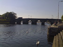
, being west of the Shannon but part of the province of Munster, is the major exception. The river represents a major physical barrier between east and west, with fewer than twenty crossing-points between Limerick
city in the south and the village of Dowra
in the north.
The river is named for Sionna, a Celtic goddess.
The Shannon has been an important waterway since antiquity, having first been mapped by the Graeco-Egyptian geographer Ptolemy
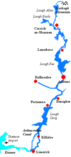
. The river flows generally southward from the Shannon Pot
in County Cavan
before turning west and emptying into the Atlantic Ocean through the 113 km (70.2 mi) long Shannon Estuary
. Limerick
city stands at the point where the river water meets the sea water
of the estuary. The Shannon is unaffected by sea tides east of Limerick.
, a small pool on the slopes of Cuilcagh Mountain
in County Cavan
, from where the young river appears as a small trout stream. Surveys have defined a 12.8 km² immediate pot catchment area covering the slopes of Cuilcagh. This area includes Garvah Lough, Cavan, 2.2 km to the northeast, drained by Pollnaowen.Note Poll nm1: hole, pit, sink, leak, aperture (The Pocket Oxford Irish Dictionary - Irish-English) Further sinks that source the pot include Pollboy and, through Shannon Cave
, Pollahune in Cavan and Polltulyard and Tullyrrakeeragh in County Fermanagh
, Northern Ireland
. The highest point in the catchment is a spring at Tiltinbane on the western end of the Cuilcagh mountain ridge.
From the Shannon Pot, the river subsumes a number of tributaries before replenishing Lough Allen at its head.
The river runs through or between 11 of Ireland's counties
, subsuming the tributary
rivers Inny
, Suck
and Brosna
, before reaching the Shannon Estuary at Limerick. At a total length of 386 kilometres (240 mi), this means it is the longest river in both Ireland and the wider British Isles
.
There are some tributaries within the River Shannon system which may have headwaters that are further in length (from source to mouth) than the Shannon Pot source.
Most notably the Owenmore river in Co. Cavan, which flows west through the valley of Glengavlin, joining the Shannon about 2 miles below Lugnashinna.
Lakes on the Shannon include Lough Allen
, Lough Ree
and Lough Derg.
 The river began flowing along its present course after the end of the last Ice Age
. Vikings settled in the region in 10th century and used the river to raid the rich monasteries deep inland. In 937 the Limerick Vikings clashed with those of Dublin on Lough Ree and were defeated.
In the 17th century, the Shannon was of major strategic importance in military campaign
in Ireland, as it formed a physical boundary between the east and west of the country. In the Irish Confederate Wars
of 1641-53, the Irish retreated behind the Shannon in 1650 and held out for two further years against English Parliamentarian
forces. In preparing a land settlement
, or plantation
after his conquest of Ireland
Oliver Cromwell
reputedly said the remaining Irish landowners would go to "Hell or Connacht", referring to their choice of forced migration
west across the river Shannon, or death, thus freeing up the eastern landholdings for the incoming English settlers.
In the Williamite war in Ireland
(1689–91), the Jacobites
also retreated behind the Shannon after their defeat at the Battle of the Boyne
in 1690. Athlone and Limerick, cities commanding bridges over the river, saw bloody sieges. (See Sieges of Limerick
and Siege of Athlone
).
As late as 1916, the leaders of the Easter Rising
planned to have their forces in the west "hold the line of the Shannon". However, in the event, the rebels were neither well enough armed nor equipped to attempt such an ambitious policy.
The Shannon river is closely bound up with Ireland's social, cultural, military, economic and political history.
 Though the Shannon has always been important for navigation in Ireland, there is a fall of only 18 m (60 ft) in the first 140 miles. Consequently it has always been shallow with 0.5 m (2 ft) depths in various places. The first serious attempt to improve things came in 1755 when the Commissioners of Inland Navigation
ordered Thomas Omer, a new, possibly Dutch immigrant from England, to commence work. He tackled four places between Lough Derg and Lough Ree
where natural navigation was obstructed, by installing lateral canals and either pound locks or flash lock
s. He then continued north of Lough Ree and made a number of similar improvements, most notably by cutting out a loop of the river at Jamestown
as well lateral canals at Roosky
and Lanesborough.
The lower Shannon between Killaloe
and Limerick
was a different story. Here the river falls by 30 m (100 ft) in only 20 km (12.4 mi). William Ockenden, also from England, was placed in charge of this in 1757 and spent £12,000 over the next four years without fully completing the task. In 1771 parliament handed over responsibility to the Limerick Navigation Company with a grant of £6,000 to add to their subscriptions of £10,000. A lateral canal 5 miles long with 6 locks was started but the company needed more to complete it. In 1791, William Chapman
was brought in to advise and discovered a sorry state of affairs. All the locks had been built to different dimensions and he spent the next three years rebuilding most of them. The navigation was finally opened in 1799, when over 1,000 tons of corn came down to Limerick as well as slates and turf. But even then, there were no tow paths in the river sections and there were still shoals in the summer months, no harbour facilities at Limerick and boats were limited to 15-20 tons load, often less.
With the approaching opening of the Grand Canal, the Grand Canal Company obtained permission from the Directors General and asked John Brownrigg to do a survey which found that much of Omer's work had deteriorated badly, so they started repairs. After protracted negotiations on costs and conditions, the work was completed by 1810 so that boats drawing 5'9" could pass from Athlone to Killaloe
. Improvements on the lower levels were also undertaken, being completed by 1814.
When the Royal Canal was completed in 1817 there was pressure to improve the navigation above Lough Ree. The Jamestown Canal was repaired, harbours built and John Killaly
designed a canal alongside the river from Battlebridge to Lough Allen
which was opened in 1820.
In the latter part of the 1820s, trade increased dramatically with the arrival of paddle-wheeled steamers
on the river which carried passengers and goods. By 1831 14,600 passengers and 36,000 tons of freight were being carried. This put new pressure on the navigation and a commission was set up resulting in the Shannon Navigation Act of 1835 appointing five Commissioners for the improvement of navigation and drainage who took possession of the whole navigation. Over the next 15 years many improvements were made but in 1849 a railway was opened from Dublin to Limerick and the number of passengers fell dramatically. Freight, which had risen to over 100,000 tons per year, was also halved.
But the work the commissioners carried out failed to solve the problems of flooding and there were disastrous floods in the early 1860s. Given the flat nature of most of the river this was not easily addressed and nothing much was done till the twentieth century.
One of the first projects of the Irish Free State
in the 1920s was to build the Ardnacrusha power station
on the lower Shannon near Killaloe. The old navigations were abandoned and the head race constructed from Lough Derg which also served for navigation. A double lock has been provided for navigation.
In the 1950s traffic began to fall and low fixed bridges would have replaced opening bridges but for the actions of the Inland Waterways Association of Ireland
which persuaded the Tánaiste
to encourage passenger launches, which kept the bridges high enough for navigation. Since then the leisure trade has steadily increased, becoming a great success story.
In mid-2007 Donald Attig
, aged 71 and Jack Donovan, aged 60 established endurance and adventure challenge benchmark records by becoming the first persons to transit the entire Shannon Navigation in an engineless boat, with live aboard capability. Their vessel and gear weighed in excess of one ton. They propelled it from the Inismagrath Marker, at the top of Lough Allen
to the port
of Tarbert, County Kerry
using sweep oar power for over 90% of the distance. The remainder was accomplished by poling and sailing. In the process they had to negotiate 33 bridges, 6 locks, and nine lakes, without the aid of an engine. One of the locks, Ardnacrusha has a descent of over 100 feet. Other smaller and lighter boats had made this journey without the aid of an engine but Donovan and Attig were the first to challenge Ireland’s longest river in an engineless live aboard type yacht. The cast iron turf burning stove in the craft they used weighed more, by itself, than some of the boats which had made an engineless transit of the Shannon. In 2008 Donald Attig
set more records by making virtually the same transit single-handed.
connecting with the River Shannon. The Royal Canal and the Grand Canal connect the Shannon to Dublin and the Irish Sea
. It is linked to the River Erne
and Lough Erne
by the Shannon-Erne Waterway
. Ballinasloe is linked to the Shannon via the River Suck
and canal, while Boyle
is connected via the Boyle canal, the river Boyle and Lough Kee. There is also the Ardnacrusha canal connected with the Ardnacrusha dam south of Lough Derg. Near Limerick, a short canal connects Plassey with the Abbey River, allowing boats to bypass the Curraghower Falls, a major obstacle to navigation. Lecarrow
village in County Roscommon
is connected to Lough Ree via the Lecarrow canal. Jamestown Canal forms a link between the River Shannon, from south of Jamestown
, to Lough Nanoge to the south of Drumsna
.
 Despite being 386 km (239.8 mi) long, it rises only 76 m (256 feet) above sea level
, so the river is easily navigable, with only a few locks along its length. There is a hydroelectric generation plant at Ardnacrusha
belonging to the ESB
.
Shipping in Shannon estuary was developed extensively during the 1980s, with over IR£
2 billion (€
2.5Billion) investment. A tanker terminal at Foynes
and an oil jetty at Shannon Airport
were built. In 1982 a large scale alumina extraction plant was built at Aughinish Island. 60,000 tonne cargo vessels now carry raw bauxite
from West African mines to the plant, where it is refined to alumina. This is then exported to Canada where it is further refined to aluminium
. 1985 saw the opening of a 915 MW coal-fired electricity plant at Moneypoint
, fed by regular visits by 150,000 tonne bulk carriers.
Rivers of Ireland
The longest river in Ireland is the The longest river in [[Ireland]] is the The longest river in [[Ireland]] is the [[River Shannon, 386 km . The river develops into three lakes along its course, [[Lough Allen]], [[Lough Ree]] and [[Lough Derg |Lough Derg]]. Of these, Lough Derg is the...
in Ireland
Ireland
Ireland is an island to the northwest of continental Europe. It is the third-largest island in Europe and the twentieth-largest island on Earth...
at 386 kilometres (240 mi). It divides the west of Ireland (principally the province
Provinces of Ireland
Ireland has historically been divided into four provinces: Leinster, Ulster, Munster and Connacht. The Irish word for this territorial division, cúige, literally meaning "fifth part", indicates that there were once five; the fifth province, Meath, was incorporated into Leinster, with parts going to...
of Connacht
Connacht
Connacht , formerly anglicised as Connaught, is one of the Provinces of Ireland situated in the west of Ireland. In Ancient Ireland, it was one of the fifths ruled by a "king of over-kings" . Following the Norman invasion of Ireland, the ancient kingdoms were shired into a number of counties for...
) from the east and south (Leinster
Leinster
Leinster is one of the Provinces of Ireland situated in the east of Ireland. It comprises the ancient Kingdoms of Mide, Osraige and Leinster. Following the Norman invasion of Ireland, the historic fifths of Leinster and Mide gradually merged, mainly due to the impact of the Pale, which straddled...
and most of Munster
Munster
Munster is one of the Provinces of Ireland situated in the south of Ireland. In Ancient Ireland, it was one of the fifths ruled by a "king of over-kings" . Following the Norman invasion of Ireland, the ancient kingdoms were shired into a number of counties for administrative and judicial purposes...
). County Clare
County Clare
-History:There was a Neolithic civilisation in the Clare area — the name of the peoples is unknown, but the Prehistoric peoples left evidence behind in the form of ancient dolmen; single-chamber megalithic tombs, usually consisting of three or more upright stones...
, being west of the Shannon but part of the province of Munster, is the major exception. The river represents a major physical barrier between east and west, with fewer than twenty crossing-points between Limerick
Limerick
Limerick is the third largest city in the Republic of Ireland, and the principal city of County Limerick and Ireland's Mid-West Region. It is the fifth most populous city in all of Ireland. When taking the extra-municipal suburbs into account, Limerick is the third largest conurbation in the...
city in the south and the village of Dowra
Dowra
Dowra is a small village in northwest County Cavan, Ireland. It is the first village on, and marks the most uppermost navigable point of, the River Shannon. On one side of its bridge is County Cavan; on the other is County Leitrim...
in the north.
The river is named for Sionna, a Celtic goddess.
The Shannon has been an important waterway since antiquity, having first been mapped by the Graeco-Egyptian geographer Ptolemy
Ptolemy
Claudius Ptolemy , was a Roman citizen of Egypt who wrote in Greek. He was a mathematician, astronomer, geographer, astrologer, and poet of a single epigram in the Greek Anthology. He lived in Egypt under Roman rule, and is believed to have been born in the town of Ptolemais Hermiou in the...
. The river flows generally southward from the Shannon Pot
Shannon Pot
Shannon Pot is a small lake in the Karst topography found on the slopes of Cuilcagh Mountain in County Cavan, Ireland. An aquifer-fed naturally fluctuating pool, it is the traditional source of the River Shannon.The pool itself is approximately in diameter. It was first explored by divers in 1971...
in County Cavan
County Cavan
County Cavan is a county in Ireland. It is part of the Border Region and is also located in the province of Ulster. It is named after the town of Cavan. Cavan County Council is the local authority for the county...
before turning west and emptying into the Atlantic Ocean through the 113 km (70.2 mi) long Shannon Estuary
Shannon Estuary
The Shannon Estuary is a large estuary where the River Shannon flows into the Atlantic Ocean. The estuary has Limerick at its head and its seaward limits are marked by Loop Head to the north and Kerry Head to the south...
. Limerick
Limerick
Limerick is the third largest city in the Republic of Ireland, and the principal city of County Limerick and Ireland's Mid-West Region. It is the fifth most populous city in all of Ireland. When taking the extra-municipal suburbs into account, Limerick is the third largest conurbation in the...
city stands at the point where the river water meets the sea water
Seawater
Seawater is water from a sea or ocean. On average, seawater in the world's oceans has a salinity of about 3.5% . This means that every kilogram of seawater has approximately of dissolved salts . The average density of seawater at the ocean surface is 1.025 g/ml...
of the estuary. The Shannon is unaffected by sea tides east of Limerick.
Geography
By tradition the Shannon is said to rise in the Shannon PotShannon Pot
Shannon Pot is a small lake in the Karst topography found on the slopes of Cuilcagh Mountain in County Cavan, Ireland. An aquifer-fed naturally fluctuating pool, it is the traditional source of the River Shannon.The pool itself is approximately in diameter. It was first explored by divers in 1971...
, a small pool on the slopes of Cuilcagh Mountain
Cuilcagh
Cuilcagh, historically Slieve Cuilcagh , is the highest mountain in the Breifne area and the 165th highest on the island of Ireland . The summit lies on the border between County Fermanagh and County Cavan , and is the highest point in both counties...
in County Cavan
County Cavan
County Cavan is a county in Ireland. It is part of the Border Region and is also located in the province of Ulster. It is named after the town of Cavan. Cavan County Council is the local authority for the county...
, from where the young river appears as a small trout stream. Surveys have defined a 12.8 km² immediate pot catchment area covering the slopes of Cuilcagh. This area includes Garvah Lough, Cavan, 2.2 km to the northeast, drained by Pollnaowen.Note Poll nm1: hole, pit, sink, leak, aperture (The Pocket Oxford Irish Dictionary - Irish-English) Further sinks that source the pot include Pollboy and, through Shannon Cave
Shannon Cave
Shannon Cave is an active stream passage cave situated in County Fermanagh, Northern Ireland and County Cavan in the Republic of Ireland.At vertical depth, it stands joint 6th with Poulnagree in County Clare in the deepest caves of Ireland...
, Pollahune in Cavan and Polltulyard and Tullyrrakeeragh in County Fermanagh
County Fermanagh
Fermanagh District Council is the only one of the 26 district councils in Northern Ireland that contains all of the county it is named after. The district council also contains a small section of County Tyrone in the Dromore and Kilskeery road areas....
, Northern Ireland
Northern Ireland
Northern Ireland is one of the four countries of the United Kingdom. Situated in the north-east of the island of Ireland, it shares a border with the Republic of Ireland to the south and west...
. The highest point in the catchment is a spring at Tiltinbane on the western end of the Cuilcagh mountain ridge.
From the Shannon Pot, the river subsumes a number of tributaries before replenishing Lough Allen at its head.
The river runs through or between 11 of Ireland's counties
Counties of Ireland
The counties of Ireland are sub-national divisions used for the purposes of geographic demarcation and local government. Closely related to the county is the County corporate which covered towns or cities which were deemed to be important enough to be independent from their counties. A county...
, subsuming the tributary
Tributary
A tributary or affluent is a stream or river that flows into a main stem river or a lake. A tributary does not flow directly into a sea or ocean...
rivers Inny
River Inny
The River Inny is a river in Ireland. It flows from Lough Kinale under the Bridge of Finea into Lough Sheelin in County Cavan and heads south to Lough Derravaragh...
, Suck
River Suck
The River Suck is a river in Ireland, approx. in length.It is the main tributary of the River Shannon. It meets the River Swilly a few kilometres north of the village of Shannonbridge to form the Suck-Swilly, which becomes the River Shannon....
and Brosna
River Brosna
The River Brosna is a river in Ireland, flowing through County Westmeath and County Offaly.The river rises in Lough Owel north of Mullingar and is a tributary of the River Shannon. It meets the Shannon at Shannon Harbour.-Course:...
, before reaching the Shannon Estuary at Limerick. At a total length of 386 kilometres (240 mi), this means it is the longest river in both Ireland and the wider British Isles
British Isles
The British Isles are a group of islands off the northwest coast of continental Europe that include the islands of Great Britain and Ireland and over six thousand smaller isles. There are two sovereign states located on the islands: the United Kingdom of Great Britain and Northern Ireland and...
.
There are some tributaries within the River Shannon system which may have headwaters that are further in length (from source to mouth) than the Shannon Pot source.
Most notably the Owenmore river in Co. Cavan, which flows west through the valley of Glengavlin, joining the Shannon about 2 miles below Lugnashinna.
Lakes on the Shannon include Lough Allen
Lough Allen
Lough Allen is a lake situated on the River Shannon, in the north-central part of Ireland, near Ireland's border region. Most of the lake is in County Leitrim, with a smaller portion in County Roscommon. The lake lies to the south of the river's source, near the Iron Mountains, and is the...
, Lough Ree
Lough Ree
Lough Ree is a lake in the midlands of Ireland, the second of the three major lakes on the River Shannon. Lough Ree is the second largest lake on the Shannon after Lough Derg. The other two major lakes are Lough Allen to the north, and Lough Derg to the south, there are also several minor lakes...
and Lough Derg.
History
Ice age
An ice age or, more precisely, glacial age, is a generic geological period of long-term reduction in the temperature of the Earth's surface and atmosphere, resulting in the presence or expansion of continental ice sheets, polar ice sheets and alpine glaciers...
. Vikings settled in the region in 10th century and used the river to raid the rich monasteries deep inland. In 937 the Limerick Vikings clashed with those of Dublin on Lough Ree and were defeated.
In the 17th century, the Shannon was of major strategic importance in military campaign
Military campaign
In the military sciences, the term military campaign applies to large scale, long duration, significant military strategy plan incorporating a series of inter-related military operations or battles forming a distinct part of a larger conflict often called a war...
in Ireland, as it formed a physical boundary between the east and west of the country. In the Irish Confederate Wars
Irish Confederate Wars
This article is concerned with the military history of Ireland from 1641-53. For the political context of this conflict, see Confederate Ireland....
of 1641-53, the Irish retreated behind the Shannon in 1650 and held out for two further years against English Parliamentarian
Parliament of England
The Parliament of England was the legislature of the Kingdom of England. In 1066, William of Normandy introduced a feudal system, by which he sought the advice of a council of tenants-in-chief and ecclesiastics before making laws...
forces. In preparing a land settlement
Act for the Settlement of Ireland 1652
The Act for the Settlement of Ireland imposed penalties including death and land confiscation against participants and bystanders of the Irish Rebellion of 1641 and subsequent unrest.-Background:...
, or plantation
Plantations of Ireland
Plantations in 16th and 17th century Ireland were the confiscation of land by the English crown and the colonisation of this land with settlers from England and the Scottish Lowlands....
after his conquest of Ireland
Cromwellian conquest of Ireland
The Cromwellian conquest of Ireland refers to the conquest of Ireland by the forces of the English Parliament, led by Oliver Cromwell during the Wars of the Three Kingdoms. Cromwell landed in Ireland with his New Model Army on behalf of England's Rump Parliament in 1649...
Oliver Cromwell
Oliver Cromwell
Oliver Cromwell was an English military and political leader who overthrew the English monarchy and temporarily turned England into a republican Commonwealth, and served as Lord Protector of England, Scotland, and Ireland....
reputedly said the remaining Irish landowners would go to "Hell or Connacht", referring to their choice of forced migration
Forced migration
Forced migration refers to the coerced movement of a person or persons away from their home or home region...
west across the river Shannon, or death, thus freeing up the eastern landholdings for the incoming English settlers.
In the Williamite war in Ireland
Williamite war in Ireland
The Williamite War in Ireland—also called the Jacobite War in Ireland, the Williamite-Jacobite War in Ireland and in Irish as Cogadh an Dá Rí —was a conflict between Catholic King James II and Protestant King William of Orange over who would be King of England, Scotland and Ireland...
(1689–91), the Jacobites
Jacobitism
Jacobitism was the political movement in Britain dedicated to the restoration of the Stuart kings to the thrones of England, Scotland, later the Kingdom of Great Britain, and the Kingdom of Ireland...
also retreated behind the Shannon after their defeat at the Battle of the Boyne
Battle of the Boyne
The Battle of the Boyne was fought in 1690 between two rival claimants of the English, Scottish and Irish thronesthe Catholic King James and the Protestant King William across the River Boyne near Drogheda on the east coast of Ireland...
in 1690. Athlone and Limerick, cities commanding bridges over the river, saw bloody sieges. (See Sieges of Limerick
Sieges of Limerick
Siege of Limerick may refer to:* Siege of Limerick , English Protestants surrendered to Confederate Catholics* Siege of Limerick , Confederate Catholics and English Royalists surrendered to English Parliamentary forces...
and Siege of Athlone
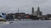
Siege of Athlone
Athlone in central Ireland, was besieged twice during the Williamite War in Ireland . The town is situated on the River Shannon and commanded the bridge crossing the river into the Jacobite held province of Connaught...
).
As late as 1916, the leaders of the Easter Rising
Easter Rising
The Easter Rising was an insurrection staged in Ireland during Easter Week, 1916. The Rising was mounted by Irish republicans with the aims of ending British rule in Ireland and establishing the Irish Republic at a time when the British Empire was heavily engaged in the First World War...
planned to have their forces in the west "hold the line of the Shannon". However, in the event, the rebels were neither well enough armed nor equipped to attempt such an ambitious policy.
The Shannon river is closely bound up with Ireland's social, cultural, military, economic and political history.
Navigation
Inland navigation
Inland navigation is transport with ships via inland water between inland ports or quays and wharfs.-See also:* Code Européen des Voies de la Navigation Intérieure -External links:...
ordered Thomas Omer, a new, possibly Dutch immigrant from England, to commence work. He tackled four places between Lough Derg and Lough Ree
Lough Ree
Lough Ree is a lake in the midlands of Ireland, the second of the three major lakes on the River Shannon. Lough Ree is the second largest lake on the Shannon after Lough Derg. The other two major lakes are Lough Allen to the north, and Lough Derg to the south, there are also several minor lakes...
where natural navigation was obstructed, by installing lateral canals and either pound locks or flash lock
Flash lock
Early locks were designed with a single gate, known as a flash lock or staunch lock. The earliest European references to what were clearly flash locks were in Roman times....
s. He then continued north of Lough Ree and made a number of similar improvements, most notably by cutting out a loop of the river at Jamestown
Jamestown, County Leitrim
Jamestown is a village on the banks of the River Shannon in County Leitrim, Ireland. It lies some 5 km east-south-east of the county town, Carrick-on-Shannon....
as well lateral canals at Roosky
Roosky
Roosky or Rooskey is a village on the River Shannon in County Roscommon, Ireland in the northern midlands of Ireland, near the point where counties Leitrim, Longford, and Roscommon meet. The N4 road from Dublin to Sligo passes by the Leitrim side of the village.- History :Roosky has had a...
and Lanesborough.
The lower Shannon between Killaloe
Killaloe, County Clare
Killaloe is a large village in east County Clare, Ireland, situated in the midwest of Ireland. The village is on the south end of Lough Derg, while the settlement spreads across the River Shannon, with the County Tipperary side known as Ballina...
and Limerick
Limerick
Limerick is the third largest city in the Republic of Ireland, and the principal city of County Limerick and Ireland's Mid-West Region. It is the fifth most populous city in all of Ireland. When taking the extra-municipal suburbs into account, Limerick is the third largest conurbation in the...
was a different story. Here the river falls by 30 m (100 ft) in only 20 km (12.4 mi). William Ockenden, also from England, was placed in charge of this in 1757 and spent £12,000 over the next four years without fully completing the task. In 1771 parliament handed over responsibility to the Limerick Navigation Company with a grant of £6,000 to add to their subscriptions of £10,000. A lateral canal 5 miles long with 6 locks was started but the company needed more to complete it. In 1791, William Chapman
William Chapman (engineer)
William Chapman was an English engineer. Born in Whitby, he worked on the construction of the Old and Humber docks in Hull, as well as many drainage and canal projects. He is credited with the invention of the bogie and articulation for rail vehicles.-Personal life:William Chapman was born on 7...
was brought in to advise and discovered a sorry state of affairs. All the locks had been built to different dimensions and he spent the next three years rebuilding most of them. The navigation was finally opened in 1799, when over 1,000 tons of corn came down to Limerick as well as slates and turf. But even then, there were no tow paths in the river sections and there were still shoals in the summer months, no harbour facilities at Limerick and boats were limited to 15-20 tons load, often less.
With the approaching opening of the Grand Canal, the Grand Canal Company obtained permission from the Directors General and asked John Brownrigg to do a survey which found that much of Omer's work had deteriorated badly, so they started repairs. After protracted negotiations on costs and conditions, the work was completed by 1810 so that boats drawing 5'9" could pass from Athlone to Killaloe
Killaloe, County Clare
Killaloe is a large village in east County Clare, Ireland, situated in the midwest of Ireland. The village is on the south end of Lough Derg, while the settlement spreads across the River Shannon, with the County Tipperary side known as Ballina...
. Improvements on the lower levels were also undertaken, being completed by 1814.
When the Royal Canal was completed in 1817 there was pressure to improve the navigation above Lough Ree. The Jamestown Canal was repaired, harbours built and John Killaly
John Killaly
John Killaly was the most significant Irish canal engineer working originally for the Grand Canal company and later, as an engineer, under the Directors-General of Inland Navigation.-Career:...
designed a canal alongside the river from Battlebridge to Lough Allen
Lough Allen
Lough Allen is a lake situated on the River Shannon, in the north-central part of Ireland, near Ireland's border region. Most of the lake is in County Leitrim, with a smaller portion in County Roscommon. The lake lies to the south of the river's source, near the Iron Mountains, and is the...
which was opened in 1820.
In the latter part of the 1820s, trade increased dramatically with the arrival of paddle-wheeled steamers
Steamboat
A steamboat or steamship, sometimes called a steamer, is a ship in which the primary method of propulsion is steam power, typically driving propellers or paddlewheels...
on the river which carried passengers and goods. By 1831 14,600 passengers and 36,000 tons of freight were being carried. This put new pressure on the navigation and a commission was set up resulting in the Shannon Navigation Act of 1835 appointing five Commissioners for the improvement of navigation and drainage who took possession of the whole navigation. Over the next 15 years many improvements were made but in 1849 a railway was opened from Dublin to Limerick and the number of passengers fell dramatically. Freight, which had risen to over 100,000 tons per year, was also halved.
But the work the commissioners carried out failed to solve the problems of flooding and there were disastrous floods in the early 1860s. Given the flat nature of most of the river this was not easily addressed and nothing much was done till the twentieth century.
One of the first projects of the Irish Free State
Irish Free State
The Irish Free State was the state established as a Dominion on 6 December 1922 under the Anglo-Irish Treaty, signed by the British government and Irish representatives exactly twelve months beforehand...
in the 1920s was to build the Ardnacrusha power station
Power station
A power station is an industrial facility for the generation of electric energy....
on the lower Shannon near Killaloe. The old navigations were abandoned and the head race constructed from Lough Derg which also served for navigation. A double lock has been provided for navigation.
In the 1950s traffic began to fall and low fixed bridges would have replaced opening bridges but for the actions of the Inland Waterways Association of Ireland
Inland Waterways Association of Ireland
The Inland Waterways Association of Ireland Cumann Uiscebhealaigh Intíre na hÉireann is a registered charity and a limited company in the Republic of Ireland and also operates in Northern Ireland. It was founded in 1954 to campaign for the conservation and development of the waterways and their...
which persuaded the Tánaiste
Tánaiste
The Tánaiste is the deputy prime minister of Ireland. The current Tánaiste is Eamon Gilmore, TD who was appointed on 9 March 2011.- Origins and etymology :...
to encourage passenger launches, which kept the bridges high enough for navigation. Since then the leisure trade has steadily increased, becoming a great success story.
In mid-2007 Donald Attig
Donald Attig
Donald Attig is an inventor, boat designer, entrepreneur, yachtsman and adventurer.-Biography:...
, aged 71 and Jack Donovan, aged 60 established endurance and adventure challenge benchmark records by becoming the first persons to transit the entire Shannon Navigation in an engineless boat, with live aboard capability. Their vessel and gear weighed in excess of one ton. They propelled it from the Inismagrath Marker, at the top of Lough Allen
Lough Allen
Lough Allen is a lake situated on the River Shannon, in the north-central part of Ireland, near Ireland's border region. Most of the lake is in County Leitrim, with a smaller portion in County Roscommon. The lake lies to the south of the river's source, near the Iron Mountains, and is the...
to the port
Port
A port is a location on a coast or shore containing one or more harbors where ships can dock and transfer people or cargo to or from land....
of Tarbert, County Kerry
Tarbert, County Kerry
Tarbert is a town in the north of County Kerry, with woodland to the south and the Shannon estuary to the north. It lies on the N69 coast road that runs along the estuary from Limerick before turning inland at Tarbert towards Listowel, and has two schools Tarbert Primary and Tarbert...
using sweep oar power for over 90% of the distance. The remainder was accomplished by poling and sailing. In the process they had to negotiate 33 bridges, 6 locks, and nine lakes, without the aid of an engine. One of the locks, Ardnacrusha has a descent of over 100 feet. Other smaller and lighter boats had made this journey without the aid of an engine but Donovan and Attig were the first to challenge Ireland’s longest river in an engineless live aboard type yacht. The cast iron turf burning stove in the craft they used weighed more, by itself, than some of the boats which had made an engineless transit of the Shannon. In 2008 Donald Attig
Donald Attig
Donald Attig is an inventor, boat designer, entrepreneur, yachtsman and adventurer.-Biography:...
set more records by making virtually the same transit single-handed.
Canals
There are also many canalsCanals of Ireland
*Boyne Navigation*Broharris Canal*Coalisland Canal *Dukart's Canal*Grand Canal*Lacy's Canal*Lagan Canal*Lecarrow Canal*Newry Canal*Royal Canal*Shannon-Erne Waterway*Strabane Canal*Ulster Canal...
connecting with the River Shannon. The Royal Canal and the Grand Canal connect the Shannon to Dublin and the Irish Sea
Irish Sea
The Irish Sea separates the islands of Ireland and Great Britain. It is connected to the Celtic Sea in the south by St George's Channel, and to the Atlantic Ocean in the north by the North Channel. Anglesey is the largest island within the Irish Sea, followed by the Isle of Man...
. It is linked to the River Erne
River Erne
The River Erne , in the northwest of Ireland, rises in Beaghy Lough, two miles south of Stradone in County Cavan and flows 64 miles through Lough Gowna, Lough Oughter and Upper and Lower Lough Erne, County Fermanagh, to the sea at Ballyshannon, County Donegal...
and Lough Erne
Lough Erne
Lough Erne, sometimes Loch Erne , is the name of two connected lakes in County Fermanagh, Northern Ireland. The lakes are widened sections of the River Erne. The river begins by flowing north, and then curves west into the Atlantic. The southern lake is further up the river and so is named Upper...
by the Shannon-Erne Waterway
Shannon-Erne Waterway
The Shannon-Erne Waterway is a canal linking the River Shannon in the Republic of Ireland with the River Erne in Northern Ireland. Managed by Waterways Ireland, the canal is in length, has sixteen locks and runs from Leitrim village in County Leitrim to Upper Lough Erne in County Fermanagh...
. Ballinasloe is linked to the Shannon via the River Suck
River Suck
The River Suck is a river in Ireland, approx. in length.It is the main tributary of the River Shannon. It meets the River Swilly a few kilometres north of the village of Shannonbridge to form the Suck-Swilly, which becomes the River Shannon....
and canal, while Boyle
Boyle, County Roscommon
Boyle is a town in County Roscommon, Ireland. It is located at the foot of the Curlew Mountains near Lough Key in the north of the county. Carrowkeel Megalithic Cemetery, the Drumanone Dolmen and the popular fishing lakes of Lough Arrow and Lough Gara are also close by...
is connected via the Boyle canal, the river Boyle and Lough Kee. There is also the Ardnacrusha canal connected with the Ardnacrusha dam south of Lough Derg. Near Limerick, a short canal connects Plassey with the Abbey River, allowing boats to bypass the Curraghower Falls, a major obstacle to navigation. Lecarrow
Lecarrow
Lecarrow is a village in County Roscommon, Ireland. Situated 17 kilometers north-west of the town of Athlone on the N61 route between Athlone and Roscommon town. A navigable canal connects it to Lough Ree, the second-largest lake on the River Shannon. Many of its residents commute to Athlone and...
village in County Roscommon
County Roscommon
County Roscommon is a county in Ireland. It is located in the West Region and is also part of the province of Connacht. It is named after the town of Roscommon. Roscommon County Council is the local authority for the county...
is connected to Lough Ree via the Lecarrow canal. Jamestown Canal forms a link between the River Shannon, from south of Jamestown
Jamestown, County Leitrim
Jamestown is a village on the banks of the River Shannon in County Leitrim, Ireland. It lies some 5 km east-south-east of the county town, Carrick-on-Shannon....
, to Lough Nanoge to the south of Drumsna
Drumsna
Drumsna is a village in County Leitrim, Ireland. It is situated 6 km east of Carrick-on-Shannon on the River Shannon and is located off the N4 National primary route which links Dublin and Sligo. The harbour dates to 1817 and was a hive of commercial waterway activity until the more northern...
.
Economics
Above mean sea level
The term above mean sea level refers to the elevation or altitude of any object, relative to the average sea level datum. AMSL is used extensively in radio by engineers to determine the coverage area a station will be able to reach...
, so the river is easily navigable, with only a few locks along its length. There is a hydroelectric generation plant at Ardnacrusha
Ardnacrusha (village)
Ardnacrusha is a village in County Clare, Munster, Ireland located on the northern bank of the Shannon River. The name derives from the phrase Ard na Croise meaning "the height of the cross", due to a large cross marker placed there in 1111 A.D...
belonging to the ESB
Electricity Supply Board
The Electricity Supply Board , is a semi-state electricity company in Ireland. While historically a monopoly, the ESB now operates as a commercial semi-state concern in a liberalised and competitive market...
.
Shipping in Shannon estuary was developed extensively during the 1980s, with over IR£
Irish pound
The Irish pound was the currency of Ireland until 2002. Its ISO 4217 code was IEP, and the usual notation was the prefix £...
2 billion (€
Euro
The euro is the official currency of the eurozone: 17 of the 27 member states of the European Union. It is also the currency used by the Institutions of the European Union. The eurozone consists of Austria, Belgium, Cyprus, Estonia, Finland, France, Germany, Greece, Ireland, Italy, Luxembourg,...
2.5Billion) investment. A tanker terminal at Foynes
Foynes
Foynes is a village and major port in County Limerick in the midwest of Ireland, located at the edge of hilly land on the southern bank of the Shannon Estuary. The population of the town was 606 as of the 2006 census.-Foynes's role in aviation:...
and an oil jetty at Shannon Airport
Shannon Airport
Shannon Airport, is one of the Republic of Ireland's three primary airports along with Dublin and Cork. In 2010 around 1,750,000 passengers passed through the airport, making it the third busiest airport in the Republic of Ireland after Dublin and Cork, and the fifth busiest airport on the island...
were built. In 1982 a large scale alumina extraction plant was built at Aughinish Island. 60,000 tonne cargo vessels now carry raw bauxite
Bauxite
Bauxite is an aluminium ore and is the main source of aluminium. This form of rock consists mostly of the minerals gibbsite Al3, boehmite γ-AlO, and diaspore α-AlO, in a mixture with the two iron oxides goethite and hematite, the clay mineral kaolinite, and small amounts of anatase TiO2...
from West African mines to the plant, where it is refined to alumina. This is then exported to Canada where it is further refined to aluminium
Aluminium
Aluminium or aluminum is a silvery white member of the boron group of chemical elements. It has the symbol Al, and its atomic number is 13. It is not soluble in water under normal circumstances....
. 1985 saw the opening of a 915 MW coal-fired electricity plant at Moneypoint
Moneypoint
Moneypoint is Ireland's largest electricity generation station and only coal-fired power station. It is located on the River Shannon near Kilrush, County Clare and was constructed at a cost of more than £700m, in one of the largest capital projects in the history of the Republic of Ireland...
, fed by regular visits by 150,000 tonne bulk carriers.
See also
- Shannon International Airport
- Shannon Town
- Cromwellian conquest of IrelandCromwellian conquest of IrelandThe Cromwellian conquest of Ireland refers to the conquest of Ireland by the forces of the English Parliament, led by Oliver Cromwell during the Wars of the Three Kingdoms. Cromwell landed in Ireland with his New Model Army on behalf of England's Rump Parliament in 1649...
- Shannon RFCShannon RFCShannon Rugby Football Club is an amateur rugby union team from Ireland, they hail from Limerick near the banks of the Shannon river. The club is a member of the Irish Rugby Football Union Munster Branch and as one of the top amateur sides in Ireland has seen many of its players progress to...