
River Lagan
Encyclopedia
The River Lagan is a major river in Northern Ireland
which runs 40 miles (60 km) from the Slieve Croob
mountain in County Down
to Belfast
where it enters Belfast Lough
, an inlet of the Irish Sea
. The River Lagan forms much of the border between County Antrim
and County Down
. It rises as a tiny fast moving stream off the Transmitter road near to the summit of Slieve Croob. From here it continues on its journey to Belfast through Dromara
and Dromore
. On the lower slopes of the mountain it is joined by another branch from Legananny (Cratlieve) Mountain, just opposite Slieve Croob. At Dromara, about four miles from its source, its height above the sea is 390 ft (119m). As the river continues on its journey to Belfast it turns east to Magheralin
into a broad plain between the Antrim plateau and the plateau of Down.
The river drains approximately 609 square km of agricultural land and flows over 70 km from the Mourne Mountains to the Stranmillis Weir, from which point on it is estuarine
. The catchment consists mainly of enriched agricultural grassland in the upper parts, with a lower section draining urban Belfast and Lisburn
. There is one significant tributary, the Ravernet River, and there are several minor tributaries, including the Carryduff River
, the River Farset
and the Blackstaff River
. Water quality is generally fair though there are localised problems and occasional pollution incidents, mainly due to effluents from farms.
, the river on which the city was built and which flows into the Lagan. Interestingly, the Farset has been superseded by the River Lagan as the most important river; the Farset now languishes under the city's High Street in obscurity.
was established by the Government
to redevelop the areas surrounding the Lagan in Belfast. Major developments of the Laganside Corporation along the river include the regeneration of the city's former Gasworks, the Odyssey
entertainment and leisure development and the Lanyon
Place development which includes the Waterfront Hall
, in many ways the flagship of the corporation.
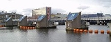
. Completed in 1994 at a cost of £14m, the weir controls the level of water upstream. One of the main functions of the weir was to put an end to the appearance of unsightly mud flats at low tide. This was mostly successful, but mud flats are still evident on the river. The weir is a series of massive steel barriers which are raised as the tide retreats so as to keep the river at an artificially constant level. This, improvements to the sewerage system and massive dredging of the river by mechanical excavator
s has led to a marked improvement in water quality and the environment around the river.
Lagan Weir
,dredging and aeration have increased water quality in the river and salmons returning. An otter and seals have followed the fish that now move up river to spawn in what was once an aquatic death trap.
, Queen's Ladies Boat Club, Methodist College Boat Club
, Royal Belfast Academical Institution
(RBAI) Rowing Club, Belfast Rowing Club (BRC) and Lagan Scullers Club (http://www.laganscullers.co.uk). The Boathouses are all based between the Governors Bridge and the Stranmillis Weir.
has embarked on a series of developments around the River Lagan. The centre-piece of this strategy has been the Lagan Valley Island complex; a new headquarters for the council and an Arts Centre, wedding and conference facilities and a restaurant. Opened in 2001 the building is surrounded by the Lagan on one side and a channel linked to the river on the other.
_at_broadwater,_near_aghalee.jpg) In the late 19th century a canal was built from Lough Neagh
In the late 19th century a canal was built from Lough Neagh
to Belfast, using some of the river as a navigable waterway and diverting water from other areas to supply separate canal sections. However by the mid-20th century the route had fallen into disuse and was largely derelict. The M1 motorway (Northern Ireland)
was built across the route. Currently, the section of the navigation's towpath
running from Lisburn
to almost the centre of Belfast
has been restored.
became extinct in the River Lagan, which enters the Irish Sea
through the port of Belfast, between 1750 and 1800, coinciding with a period of major population growth, industrialisation and the construction of a navigable waterway based on the river. The latest record of a salmon population in the river dates from 1744. From 1950 to 1990, water quality in the river improved as a result of improved sewage treatment, the Lagan Navigation was abandoned and fell into disuse, and many industrial effluents were diverted to sewer. A fish survey in the early 1970s found no fish at all in the urban reach of river through Belfast. Brown trout
and several other species remained present in the upper reaches of the river throughout the worst of the downstream urban problems. The 1980s saw some recreational angling for non-migratory fish developing in the Belfast reaches of the river, and there were very occasional reports of migratory salmon or sea trout being seen in the river. In 1991, the first of a series of stockings took place and the first adult salmon returned to the Lagan in 1993.
Northern Ireland
Northern Ireland is one of the four countries of the United Kingdom. Situated in the north-east of the island of Ireland, it shares a border with the Republic of Ireland to the south and west...
which runs 40 miles (60 km) from the Slieve Croob
Slieve Croob
Slieve Croob is the tallest of a group of peaks in the middle of County Down, Northern Ireland. These peaks lie north of the Mourne Mountains, between the village of Dromara and the town of Castlewellan. Slieve Croob has been designated an Area of Outstanding Natural Beauty...
mountain in County Down
County Down
-Cities:*Belfast *Newry -Large towns:*Dundonald*Newtownards*Bangor-Medium towns:...
to Belfast
Belfast
Belfast is the capital of and largest city in Northern Ireland. By population, it is the 14th biggest city in the United Kingdom and second biggest on the island of Ireland . It is the seat of the devolved government and legislative Northern Ireland Assembly...
where it enters Belfast Lough
Belfast Lough
Belfast Lough is a large, natural intertidal sea lough at the mouth of the River Lagan on the east coast of Northern Ireland. The inner part of the lough comprises a series of mudflats and lagoons. The outer lough is restricted to mainly rocky shores with some small sandy bays...
, an inlet of the Irish Sea
Irish Sea
The Irish Sea separates the islands of Ireland and Great Britain. It is connected to the Celtic Sea in the south by St George's Channel, and to the Atlantic Ocean in the north by the North Channel. Anglesey is the largest island within the Irish Sea, followed by the Isle of Man...
. The River Lagan forms much of the border between County Antrim
County Antrim
County Antrim is one of six counties that form Northern Ireland, situated in the north-east of the island of Ireland. Adjoined to the north-east shore of Lough Neagh, the county covers an area of 2,844 km², with a population of approximately 616,000...
and County Down
County Down
-Cities:*Belfast *Newry -Large towns:*Dundonald*Newtownards*Bangor-Medium towns:...
. It rises as a tiny fast moving stream off the Transmitter road near to the summit of Slieve Croob. From here it continues on its journey to Belfast through Dromara
Dromara
Dromara is a small village and townland in County Down, Northern Ireland. It lies to the southwest of Ballynahinch on the northern slopes of Slieve Croob, with the River Lagan flowing through it. In the 2001 Census it had a population of 597 people....
and Dromore
Dromore, County Down
Dromore is a small market town in the Banbridge District of County Down, Northern Ireland. It is south-west of Belfast, on the A1 Belfast – Dublin road. The 2001 Census recorded a population of 4,968 people....
. On the lower slopes of the mountain it is joined by another branch from Legananny (Cratlieve) Mountain, just opposite Slieve Croob. At Dromara, about four miles from its source, its height above the sea is 390 ft (119m). As the river continues on its journey to Belfast it turns east to Magheralin
Magheralin
Magheralin is a village in County Down, Northern Ireland. It is on the main Moira to Lurgan road, beside the River Lagan. It had a population of 1,144 people in the 2001 Census. It is within the Craigavon Borough Council area....
into a broad plain between the Antrim plateau and the plateau of Down.
The river drains approximately 609 square km of agricultural land and flows over 70 km from the Mourne Mountains to the Stranmillis Weir, from which point on it is estuarine
Estuary
An estuary is a partly enclosed coastal body of water with one or more rivers or streams flowing into it, and with a free connection to the open sea....
. The catchment consists mainly of enriched agricultural grassland in the upper parts, with a lower section draining urban Belfast and Lisburn
Lisburn
DemographicsLisburn Urban Area is within Belfast Metropolitan Urban Area and is classified as a Large Town by the . On census day there were 71,465 people living in Lisburn...
. There is one significant tributary, the Ravernet River, and there are several minor tributaries, including the Carryduff River
Carryduff River
The Carryduff River is a minor river in County Down, Northern Ireland. It is not navigable.The river rises in Killinure townland, in the boggy ground at the northern base of Ouley Hill , and is fed by numerous drainage ditches as it passes through the farmland to the south of the town of Carryduff...
, the River Farset
River Farset
The River Farset is a river in Belfast, Northern Ireland, a tributary of the River Lagan. It is on the County Antrim side of the Lagan and joins the Lagan close to its outflow into Belfast Lough. The River Farset is now contained within a tunnel under Belfast's High Street; a tunnel supposedly big...
and the Blackstaff River
Blackstaff River
Blackstaff River is a watercourse that flows along the M1 Motorway and then through a series of piped sections under Belfast, discharging into Belfast Lough....
. Water quality is generally fair though there are localised problems and occasional pollution incidents, mainly due to effluents from farms.
The Lagan in Belfast
The name Belfast originates from the Irish Béal Feirste, or the mouth of the FarsetRiver Farset
The River Farset is a river in Belfast, Northern Ireland, a tributary of the River Lagan. It is on the County Antrim side of the Lagan and joins the Lagan close to its outflow into Belfast Lough. The River Farset is now contained within a tunnel under Belfast's High Street; a tunnel supposedly big...
, the river on which the city was built and which flows into the Lagan. Interestingly, the Farset has been superseded by the River Lagan as the most important river; the Farset now languishes under the city's High Street in obscurity.
Laganside Corporation
In 1989 the Laganside CorporationLaganside Corporation
The Laganside Corporation was a non-departmental public body formed by the Laganside Development Order 1989 with the goal of regenerating large sections of land in Belfast, Northern Ireland adjacent to the River Lagan...
was established by the Government
Politics of the United Kingdom
The politics of the United Kingdom takes place within the framework of a constitutional monarchy, in which the Monarch is the head of state and the Prime Minister of the United Kingdom is the head of government...
to redevelop the areas surrounding the Lagan in Belfast. Major developments of the Laganside Corporation along the river include the regeneration of the city's former Gasworks, the Odyssey
Odyssey (Belfast)
The Odyssey Arena is a large sports and entertainment centre situated in Titanic Quarter, Belfast, Northern Ireland. It was jointly funded by the Millennium Commission, the Laganside Corporation, the DCAL, the Sheridan Group and the Sports Council for Northern Ireland. The Arena opened in 2000 with...
entertainment and leisure development and the Lanyon
Charles Lanyon
Sir Charles Lanyon DL, JP was an English architect of the 19th century. His work is most closely associated with Belfast, Northern Ireland.-Biography:Lanyon was born in Eastbourne, Sussex in 1813...
Place development which includes the Waterfront Hall
Waterfront Hall
The Waterfront Hall is a multi-purpose facility, in Belfast, Northern Ireland, designed by local architects' firm Robinson McIlwaine. Practice partner Peter McGukin was the project architect....
, in many ways the flagship of the corporation.
Lagan Weir
One of the earliest and most important undertakings of the Corporation was the Lagan WeirLagan Weir
The Lagan Weir, completed in 1994, at a cost of £14m, is located across the Lagan between the Queen Elizabeth Bridge and the M3 bridge in Belfast, Northern Ireland...
. Completed in 1994 at a cost of £14m, the weir controls the level of water upstream. One of the main functions of the weir was to put an end to the appearance of unsightly mud flats at low tide. This was mostly successful, but mud flats are still evident on the river. The weir is a series of massive steel barriers which are raised as the tide retreats so as to keep the river at an artificially constant level. This, improvements to the sewerage system and massive dredging of the river by mechanical excavator
Excavator
Excavators are heavy construction equipment consisting of a boom, stick, bucket and cab on a rotating platform . The house sits atop an undercarriage with tracks or wheels. A cable-operated excavator uses winches and steel ropes to accomplish the movements. They are a natural progression from the...
s has led to a marked improvement in water quality and the environment around the river.
Lagan Weir
Lagan Weir
The Lagan Weir, completed in 1994, at a cost of £14m, is located across the Lagan between the Queen Elizabeth Bridge and the M3 bridge in Belfast, Northern Ireland...
,dredging and aeration have increased water quality in the river and salmons returning. An otter and seals have followed the fish that now move up river to spawn in what was once an aquatic death trap.
Sport
The river is used by a number of rowing clubs including Queen's University Boat ClubQueen's University Belfast Boat Club
Queen's University Belfast Boat Club is the Boat Club of Queen's University Belfast which is in Belfast, Northern Ireland. It is based on the River Lagan in the Stranmillis area of the city, about 10 minutes walk from the university.-1931–1951:...
, Queen's Ladies Boat Club, Methodist College Boat Club
Methodist College Belfast
Methodist College Belfast , styled locally as Methody, is a voluntary grammar school in Belfast, Northern Ireland, one of eight Northern Irish schools represented on the Headmasters' and Headmistresses' Conference, and is a member of the Independent Schools Council...
, Royal Belfast Academical Institution
Royal Belfast Academical Institution
The Royal Belfast Academical Institution, is a Grammar School in Belfast, Northern Ireland. Locally referred to as Inst, the school educates boys from ages 11–18...
(RBAI) Rowing Club, Belfast Rowing Club (BRC) and Lagan Scullers Club (http://www.laganscullers.co.uk). The Boathouses are all based between the Governors Bridge and the Stranmillis Weir.
Dredging
In September 2010, dredging commenced on the river Lagan. The operation is expected to last until spring 2011 and will create 28 jobs.The Lagan in Lisburn
In a similar way to the regeneration of Belfast riverside Lisburn City CouncilLisburn City Council
Lisburn City Council is a district council covering an area partly in County Antrim and partly in County Down in Northern Ireland. The council is the second largest in the Belfast Metropolitan Area. Council headquarters are in the city of Lisburn, upon which was conferred city status in May 2002 as...
has embarked on a series of developments around the River Lagan. The centre-piece of this strategy has been the Lagan Valley Island complex; a new headquarters for the council and an Arts Centre, wedding and conference facilities and a restaurant. Opened in 2001 the building is surrounded by the Lagan on one side and a channel linked to the river on the other.
The Lagan Navigation
Lough Neagh
Lough Neagh, sometimes Loch Neagh, is a large freshwater lake in Northern Ireland. Its name comes .-Geography:With an area of , it is the largest lake in the British Isles and ranks among the forty largest lakes of Europe. Located twenty miles to the west of Belfast, it is approximately twenty...
to Belfast, using some of the river as a navigable waterway and diverting water from other areas to supply separate canal sections. However by the mid-20th century the route had fallen into disuse and was largely derelict. The M1 motorway (Northern Ireland)
M1 motorway (Northern Ireland)
The M1 is a motorway in Northern Ireland. It is the longest motorway in Northern Ireland and runs for from Belfast to Dungannon through County Down and County Armagh...
was built across the route. Currently, the section of the navigation's towpath
Towpath
A towpath is a road or trail on the bank of a river, canal, or other inland waterway. The purpose of a towpath is to allow a land vehicle, beasts of burden, or a team of human pullers to tow a boat, often a barge...
running from Lisburn
Lisburn
DemographicsLisburn Urban Area is within Belfast Metropolitan Urban Area and is classified as a Large Town by the . On census day there were 71,465 people living in Lisburn...
to almost the centre of Belfast
Belfast
Belfast is the capital of and largest city in Northern Ireland. By population, it is the 14th biggest city in the United Kingdom and second biggest on the island of Ireland . It is the seat of the devolved government and legislative Northern Ireland Assembly...
has been restored.
Angling
Atlantic salmonAtlantic salmon
The Atlantic salmon is a species of fish in the family Salmonidae, which is found in the northern Atlantic Ocean and in rivers that flow into the north Atlantic and the north Pacific....
became extinct in the River Lagan, which enters the Irish Sea
Irish Sea
The Irish Sea separates the islands of Ireland and Great Britain. It is connected to the Celtic Sea in the south by St George's Channel, and to the Atlantic Ocean in the north by the North Channel. Anglesey is the largest island within the Irish Sea, followed by the Isle of Man...
through the port of Belfast, between 1750 and 1800, coinciding with a period of major population growth, industrialisation and the construction of a navigable waterway based on the river. The latest record of a salmon population in the river dates from 1744. From 1950 to 1990, water quality in the river improved as a result of improved sewage treatment, the Lagan Navigation was abandoned and fell into disuse, and many industrial effluents were diverted to sewer. A fish survey in the early 1970s found no fish at all in the urban reach of river through Belfast. Brown trout
Brown trout
The brown trout and the sea trout are fish of the same species....
and several other species remained present in the upper reaches of the river throughout the worst of the downstream urban problems. The 1980s saw some recreational angling for non-migratory fish developing in the Belfast reaches of the river, and there were very occasional reports of migratory salmon or sea trout being seen in the river. In 1991, the first of a series of stockings took place and the first adult salmon returned to the Lagan in 1993.