

Risks to the Glen Canyon Dam
Encyclopedia

Glen Canyon Dam
Glen Canyon Dam is a concrete arch dam on the Colorado River in northern Arizona in the United States, just north of Page. The dam was built to provide hydroelectricity and flow regulation from the upper Colorado River Basin to the lower. Its reservoir is called Lake Powell, and is the second...
, a concrete arch dam on the Colorado River
Colorado River
The Colorado River , is a river in the Southwestern United States and northwestern Mexico, approximately long, draining a part of the arid regions on the western slope of the Rocky Mountains. The watershed of the Colorado River covers in parts of seven U.S. states and two Mexican states...
in the U.S. state of Arizona
Arizona
Arizona ; is a state located in the southwestern region of the United States. It is also part of the western United States and the mountain west. The capital and largest city is Phoenix...
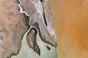
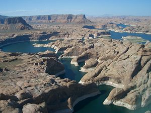
, has been associated with a large amount of risk, most notably the risk of its siltation and failure. Because of high silt content carried in by the Colorado and San Juan rivers, Lake Powell
Lake Powell
Lake Powell is a huge reservoir on the Colorado River, straddling the border between Utah and Arizona . It is the second largest man-made reservoir in the United States behind Lake Mead, storing of water when full...
is gradually filling with sediment, decreasing its capacity; eventually the sediment will build up against the dam and affect its safe operation.
The dam, anchored in unstable Navajo sandstone
Navajo Sandstone
Navajo Sandstone is a geologic formation in the Glen Canyon Group that is spread across the U.S. states of northern Arizona, northwest Colorado, and Utah; as part of the Colorado Plateau province of the United States...
(sometimes said to be "solidified sand dunes"), nearly failed in 1983 as the result of a flood on the upper Colorado River.
Siltation, degradation of concrete and reinforcements, spillway operational problems, and unstable dam abutments are all key factors that affect the safe operation of the dam.
It is estimated that breaching of the dam for any reason would produce a floodwave that would overtop the Hoover Dam
Hoover Dam
Hoover Dam, once known as Boulder Dam, is a concrete arch-gravity dam in the Black Canyon of the Colorado River, on the border between the US states of Arizona and Nevada. It was constructed between 1931 and 1936 during the Great Depression and was dedicated on September 30, 1935, by President...
by up to 230 feet (70.1 m), i.e. a megatsunami
Megatsunami
Megatsunami is an informal term to describe a tsunami that has initial wave heights that are much larger than normal tsunamis...
.
As the dam's useful lifespan is estimated by some to be no more than 85 to 100 years, the dam has been called "America's most regretted environmental mistake" by David Brower, then-head of the Sierra Club
Sierra Club
The Sierra Club is the oldest, largest, and most influential grassroots environmental organization in the United States. It was founded on May 28, 1892, in San Francisco, California, by the conservationist and preservationist John Muir, who became its first president...
. Other estimates, by the Bureau of Reclamation and others suggest a lifespan of between 500–700 years.
Siltation
The Colorado River carries an estimated 44 million tons of sediment annually at Glen CanyonGlen Canyon
Glen Canyon is a canyon that is located in southeastern and south central Utah and northwestern Arizona within the Vermilion Cliffs area. It was carved by the Colorado River....
, and as Lake Powell is the farthest large reservoir upstream on the Colorado River mainstem, the sediment load is completely trapped in the reservoir as the Colorado discharges into it. This sediment is creating a steadily advancing "toe" of sediment, i.e. an underwater alluvial fan
Alluvial fan
An alluvial fan is a fan-shaped deposit formed where a fast flowing stream flattens, slows, and spreads typically at the exit of a canyon onto a flatter plain. A convergence of neighboring alluvial fans into a single apron of deposits against a slope is called a bajada, or compound alluvial...
, that is advancing towards the dam. It is estimated that the sediment will reach the dam base in a minimum as low as eighty to one hundred years or as far as 500 to 700 years, although it will take much more time for the sediment deposited there to reach higher on the dam and clog the outlet works
Outlet works
A set of outlet works is a device used to release and regulate water flow from a dam. Such devices usually consist of one or more pipes or tunnels through the embankment of the dam, directing water usually under high pressure to the river downstream...
, the lowest openings in the upstream face of the dam. If water level then drops, it may lower below the penstock
Penstock
A penstock is a sluice or gate or intake structure that controls water flow, or an enclosed pipe that delivers water to hydraulic turbines and sewerage systems. It is a term that has been inherited from the technology of wooden watermills....
openings, which are higher up on the dam face, then the release capacity of the dam drops to zero, and the Colorado River below the dam could remain dry until the next major spring inflow, and only springs, seeps and tributaries such as the Paria
Paria River
The Paria River is a tributary of the Colorado River, approximately long, in southern Utah and northern Arizona in the United States. It drains a rugged and arid region northwest of the Colorado, flowing through roadless slot canyons along part of its course....
, Little Colorado
Little Colorado River
The Little Colorado River is a river in the U.S. state of Arizona, providing the principal drainage from the Painted Desert region. Together with its major tributary, the Puerco River, it drains an area of about in eastern Arizona and western New Mexico...
and Virgin River
Virgin River
The Virgin River is a tributary of the Colorado River in the U.S. states of Utah, Nevada, and Arizona. The river is about long. It was designated Utah's first wild and scenic river in 2009, during the centennial celebration of Zion National Park.-Course:...
would replenish its flow during these times, perhaps causing unprecedented drops in levels of Lake Mead
Lake Mead
Lake Mead is the largest reservoir in the United States. It is located on the Colorado River about southeast of Las Vegas, Nevada, in the states of Nevada and Arizona. Formed by water impounded by the Hoover Dam, it extends behind the dam, holding approximately of water.-History:The lake was...
as well.
The primary failure mode for Glen Canyon dam will undoubtedly be an overtopping one spring caused by insufficient storage capacity (either a huge inflow, bigger than 1983, or insufficient storage capacity because the lake was too full of either water or sediment).
Lake Mead
Lake Mead is the largest reservoir in the United States. It is located on the Colorado River about southeast of Las Vegas, Nevada, in the states of Nevada and Arizona. Formed by water impounded by the Hoover Dam, it extends behind the dam, holding approximately of water.-History:The lake was...
itself, where, before the completion of Glen Canyon Dam, ten percent of its storage was already compromised by sediment. When Lake Powell levels drop, sediments deposited in its upper reaches are carried into the receding water by the Colorado and its tributaries. One large flash flood
Flash flood
A flash flood is a rapid flooding of geomorphic low-lying areas—washes, rivers, dry lakes and basins. It may be caused by heavy rain associated with a storm, hurricane, or tropical storm or meltwater from ice or snow flowing over ice sheets or snowfields...
caused by heavy rainfall could move all or most of these sediments into Lake Powell, creating a sudden loss of storage capacity. The only way to control sediment flow in the reservoir, without removing the dam outright, is by dredging. Unfortunately, as Glen Canyon is remote and isolated, the cost of dredging (which would require to remove 84 tons per minute in order to keep pace with advancing sediment) is extremely high. Although the Colorado River Delta
Colorado River Delta
The Colorado River Delta is the region where the Colorado River flows into the Gulf of California . The delta is part of a larger geologic region called the Salton Trough. Historically, the interaction of the river’s flow and the ocean’s tide created a dynamic environment, supporting freshwater,...
is the most ecologically friendly place for sediment to be dumped, the cost of transporting sediment from Glen Canyon to the Delta, which not only involves a long distance travelled as well as international negotiations (the Delta is located in Mexico) is $2.6 billion USD per year.
1983
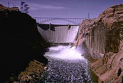
In May 1983, three years after Lake Powell had first filled, an unusually long-lasting winter over the 108335 square miles (280,586.4 km²) Colorado River basin above the Glen Canyon Dam ended with a sudden influx of warm weather. Rain and snowmelt joined together to produce a combined inflow of over 111500 ft3 per second, however, the Bureau of Reclamation predicts that the probable maximum flood at Glen Canyon is 697000 ft3 per second, almost 7 times that total,and the average annual peak flow prior to 1963 was 93400 ft3 per second.
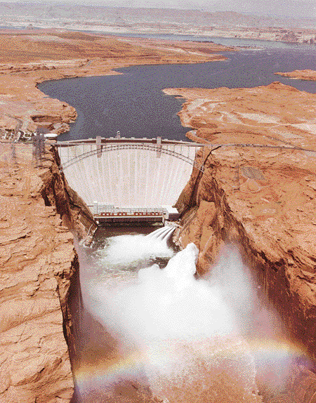
The Glen Canyon Dam has two tunnel spillways, capable of bypassing 276000 ft3/s. Making use of part of the old diversion tunnels that were used when the dam was built, the spillways were thus more economical to construct, but have less capacity and must have at least 30 percent clearance between the water level and the tunnel ceiling. The dam also has a set of river outlet works
Outlet works
A set of outlet works is a device used to release and regulate water flow from a dam. Such devices usually consist of one or more pipes or tunnels through the embankment of the dam, directing water usually under high pressure to the river downstream...
designed to release 40000 ft3 per second, however, flaws in their expansion joint
Expansion joint
An expansion joint or movement joint is an assembly designed to safely absorb the heat-induced expansion and contraction of various construction materials, to absorb vibration, to hold certain parts together, or to allow movement due to ground settlement or earthquakes...
s limit their releases to 15000 ft3 per second. Finally, there are the releases from the power plant of the dam, which is capable of releasing 31500 ft3 per second.
Penstock
A penstock is a sluice or gate or intake structure that controls water flow, or an enclosed pipe that delivers water to hydraulic turbines and sewerage systems. It is a term that has been inherited from the technology of wooden watermills....
s were opened to full release, and as inflow continued to rise, the river outlet works were also opened, discharging more water into the river below. The reservoir, however, continued to rise, and Reclamation finally decided to raise the floodgate
Floodgate
Floodgates are adjustable gates used to control water flow in flood barriers, reservoir, river, stream, or levee systems. They may be designed to set spillway crest heights in dams, to adjust flow rates in sluices and canals, or they may be designed to stop water flow entirely as part of a levee or...
s. Other than test runs, this was the first time that the spillways had ever been put into operation for practical reasons, this time running at 20000 ft3 per second per tunnel. In several days, noticeable vibrations began to make themselves felt in the dam wall and surrounding rock. A close examination of water exiting the spillways revealed noticeable debris, including sandstone, which signaled severe erosion taking place. Reclamation responded by reducing releases by half, however, the rumblings continued, and it was not long before the spillways were shut down completely for examination. The rumblings were so notable that a worker in the employee dining room, located near the power plant, was reported to say that it "sounded like the barrages that he had experienced in Vietnam".
Subsequently, inspection crews were lowered down the spillway tunnels in a small cart to assess damage. What they found was that at tunnel bends, the force of the water, by means of cavitation
Cavitation
Cavitation is the formation and then immediate implosion of cavities in a liquidi.e. small liquid-free zones that are the consequence of forces acting upon the liquid...
, had damaged and eroded the lining of the tunnel, which was 3 foot (0.9144 m) concrete
Concrete
Concrete is a composite construction material, composed of cement and other cementitious materials such as fly ash and slag cement, aggregate , water and chemical admixtures.The word concrete comes from the Latin word...
. At some places the erosion had completely worn away the lining, exposing the soft sandstone underneath; this was the source of much of the debris. The tunnels could not be closed for long, however: the National Weather Service
National Weather Service
The National Weather Service , once known as the Weather Bureau, is one of the six scientific agencies that make up the National Oceanic and Atmospheric Administration of the United States government...
was reporting more rainstorms in the Colorado River Basin, and the reservoir continued to rise. Reclamation opened the left spillway to 12000 ft3 per second; the right, which had suffered worse damage, was carrying 4000 ft3 per second. As the water level increased, wooden flashboards were installed on top of the spillway gates; this allowed reservoir water to rise 4 feet (1.2 m) while not increasing releases. The left tunnel, however, was suffering damage unknown until it began to show itself as a "surging, boiling flow that filled the portal". The tunnel was now forming a hydraulic jump
Hydraulic jump
A hydraulic jump is a phenomenon in the science of hydraulics which is frequently observed in open channel flow such as rivers and spillways. When liquid at high velocity discharges into a zone of lower velocity, a rather abrupt rise occurs in the liquid surface...
as it was turned into a "pressure conduit" by the surging flow of water, and as erosion threatened to collapse the tunnel, Reclamation had to open the gates further. The extra water would help to support the tunnel, but it would increase damage to the tunnel walls. Eventually, Reclamation attached even more boards to the spillway gates, allowing the reservoir to rise a further 8 feet (2.4 m) without increasing releases.
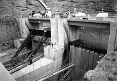
After the flood, it was suggested that the flashboards atop the spillway gates should be replaced with stronger boards and kept permanently; this would allow an "insurance" against a 1983-reminiscent flood. An air slot was constructed in each spillway tunnel afterwards to prevent catastrophic cavitation events like those of 1983. Most surprising, however, is that the flood of 1983, although it nearly caused catastrophic disaster, it was a "relatively small flood". It was, in fact, only a 25 year flood, or a flood that has a four percent chance of occurring in any given year.
1984
Snowpack
Snowpack forms from layers of snow that accumulate in geographic regions and high altitudes where the climate includes cold weather for extended periods during the year. Snowpacks are an important water resource that feed streams and rivers as they melt. Snowpacks are the drinking water source for...
was reported in the upper Colorado basin. It was feared that this would produce a flood greater than the 1983 one, and as the spillway repairs continued, water was constantly released through the dam power plant and outlet works
Outlet works
A set of outlet works is a device used to release and regulate water flow from a dam. Such devices usually consist of one or more pipes or tunnels through the embankment of the dam, directing water usually under high pressure to the river downstream...
, a rate of roughly 45000 ft3 per second.
As attempts were made to draw down Lake Powell, however, the upstream snowpack began to melt in spring of 1984, and water levels were soon rising again. Its highest level was reached in late June, several inches below the top of the flashboards. As summer continued, inflows decreased and the reservoir finally began to release. On August 12, 1984, the left spillway was repaired and was tested at 50000 ft3 per second for several days. No notable damage was recorded in the spillways. An added benefit was that the power plant, after running at full capacity for months, had provided more power than usual, thus replacing power that would otherwise be generated by oil.
Factors contributing to a dam failure
In the Colorado River floods of 1983, the Glen Canyon Dam exhibited poorly designed and cavitating spillways, strong structural vibrations and as a result, an inability to bypass enough floodwater in the event of a major flood. After the 1983 flood, however, the spillways were redesigned to reduce or eliminate the cavitation damage seen in the 1983 flood by the use of air slots. These spillway revisions were tested successfully in 1984. This revision basically eliminates the possibility of the dam being undermined via erosion of the spillways, and reduces the danger of the dam being over topped - the only reason the lake rose as high as it did was due to the flashboards placed atop the closed spillway gates. If the reservoir rises over the dam crest it would overtop the dam and gradually erode it. This would be dangerous not only because the dam power plant is located at its base, but because the dam is built within porous, erosion-prone Navajo SandstoneNavajo Sandstone
Navajo Sandstone is a geologic formation in the Glen Canyon Group that is spread across the U.S. states of northern Arizona, northwest Colorado, and Utah; as part of the Colorado Plateau province of the United States...
; an overtopping would likely lead to erosion of the dam abutments and a subsequent failure. In 1990, the Bureau of Reclamation prepared a study for a Glen Canyon Dam failure, predicting that the resulting flood would scour the bottom few hundred feet of the Grand Canyon, overtop Hoover Dam
Hoover Dam
Hoover Dam, once known as Boulder Dam, is a concrete arch-gravity dam in the Black Canyon of the Colorado River, on the border between the US states of Arizona and Nevada. It was constructed between 1931 and 1936 during the Great Depression and was dedicated on September 30, 1935, by President...
, and cause severe damage all along the lower Colorado River.
Impacts of a failure
Lake Mead
Lake Mead is the largest reservoir in the United States. It is located on the Colorado River about southeast of Las Vegas, Nevada, in the states of Nevada and Arizona. Formed by water impounded by the Hoover Dam, it extends behind the dam, holding approximately of water.-History:The lake was...
, Davis Dam
Davis Dam
Davis Dam is a dam on the Colorado River about downstream from Hoover Dam. It stretches across the border between Arizona and Nevada. Originally called Bullhead Dam, Davis Dam was renamed after Arthur Powell Davis, who was the director of the U.S. Bureau of Reclamation from 1914 to 1932...
forming Lake Mohave
Lake Mohave
Lake Mohave is a reservoir formed by Davis Dam on the Colorado River, which defines the border between Nevada and Arizona in the United States. The lake lies at an elevation of near Laughlin, Nevada, Searchlight, Nevada, Cottonwood Cove, Nevada, and Bullhead City, Arizona, about downstream from...
, Parker Dam
Parker Dam
Parker Dam is a concrete arch-gravity dam that crosses the Colorado River downstream of Hoover Dam. Built between 1934 and 1938 by the Bureau of Reclamation, it is high, of which are below the riverbed, making it "the deepest dam in the world". The dam's primary functions are to create a...
forming Lake Havasu
Lake Havasu
Lake Havasu is a large reservoir behind Parker Dam on the Colorado River, on the border between California and Arizona. Lake Havasu City sits on the lake's eastern shore. The lake has a capacity of . The concrete arch dam was built by the United States Bureau of Reclamation between 1934 and 1938...
, Palo Verde Dam
Palo Verde Dam
The Palo Verde Dam is a diversion dam on the Colorado River in La Paz County, Arizona, and Riverside County, California, in the southwestern United States, approximately northeast of Blythe. The dam is earthen and rockfill, built solely to divert water into irrigation canals serving the Palo...
, and other dams and reservoirs. Lake Havasu is also the starting point for the Colorado River Aqueduct
Colorado River Aqueduct
The Colorado River Aqueduct, or CRA, is a water conveyance in Southern California in the United States, operated by the Metropolitan Water District of Southern California . The aqueduct impounds water from the Colorado River at Lake Havasu on the California-Arizona border west across the Mojave...
, and in the event of a Glen Canyon Dam failure, water supply would be cut off to regions of southern California depending on damage to canal headworks. There is also a potential for the floodwave to once again break through Imperial Valley
Imperial Valley
The Imperial Valley is an agricultural area of Southern California's Imperial County. It is located in southeastern Southern California, centered around the city of El Centro. Locally, the terms "Imperial Valley" and "Imperial County" are used synonymously. The Valley is bordered between the...
canal levees and flood the Salton Sea
Salton Sea
The Salton Sea is a shallow, saline, endorheic rift lake located directly on the San Andreas Fault, predominantly in California's Imperial Valley. The lake occupies the lowest elevations of the Salton Sink in the Colorado Desert of Imperial and Riverside counties in Southern California. Like Death...
basin, as it did in 1905.
The failure of Glen Canyon Dam would also destroy up to 964 known archaeological sites, including 264 that it currently affects in the Grand Canyon.
As the Glen Canyon Dam is the central element of the Colorado River Storage Project
Colorado River Storage Project
The Colorado River Storage Project is a United States Bureau of Reclamation project designed to oversee the development of the upper Colorado River basin...
and also is vital for a large portion of Southwest water supply, its failure would definitely cause severe water shortages in at least the areas covered by the system, which include residences, farmland and industry. Recreation on Lake Powell, which currently generates revenue for Glen Canyon National Recreation Area
Glen Canyon National Recreation Area
Glen Canyon National Recreation Area is a recreation and conservation unit of the National Park Service that encompasses the area around Lake Powell and lower Cataract Canyon in Utah and Arizona, covering 1,254,429 acres of mostly desert...
and the town of Page, Arizona
Page, Arizona
Page is a city in Coconino County, Arizona, United States, near the Glen Canyon Dam and Lake Powell. According to 2005 Census Bureau estimates, the population of the city is 6,794.-Geography:Page is located at ....
, would also disappear with a dam failure although tourism is likely to continue or return to the broken dam site and the resurfaced Glen Canyon. As the dam generates a moderate amount of power, only 451 MW, the loss of the power plant would not have nationwide effects, though a loss of regional power and revenue for Reclamation would be instant. A failure, however, would increase flows in the river over the long term as a sizable amount of water evaporates at Lake Powell instead of continuing downstream.