

Rhyolite, Nevada
Encyclopedia
Rhyolite is a ghost town
in Nye County
, in the U.S. state of Nevada
. It is located in the Bullfrog Hills
, about 120 miles (193.1 km) northwest of Las Vegas
, near the eastern edge of Death Valley
. The town began in early 1905 as one of several mining camps that sprang up after a prospecting
discovery in the surrounding hills. During an ensuing gold rush
, thousands of gold-seekers, developers, miners, and service providers flocked to the Bullfrog Mining District. Many settled in Rhyolite, which lay in a sheltered desert basin near the region's biggest producer, the Montgomery Shoshone Mine.
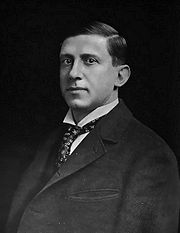
Industrialist Charles M. Schwab
bought the Montgomery Shoshone Mine in 1906 and invested heavily in infrastructure including piped water, electric lines, and railroad transportation that served the town as well as the mine. By 1907, Rhyolite had electric lights, water mains, telephones, newspapers, a hospital, a school, an opera house, and a stock exchange
. Published estimates of the town's peak population vary widely, but scholarly sources generally place it in a range between 3,500 and 5,000 in 1907–08.
Rhyolite declined almost as rapidly as it rose. After the richest ore
was exhausted, production fell. The 1906 San Francisco earthquake
and the financial panic of 1907
made it more difficult to raise development capital. In 1908, investors in the Montgomery Shoshone Mine, concerned that it was overvalued, ordered an independent study. When the study's findings proved unfavorable, the company's stock value crashed, further restricting funding. By the end of 1910, the mine was operating at a loss, and it closed in 1911. By this time, many out-of-work miners had moved elsewhere, and Rhyolite's population dropped well below 1,000. By 1920, it was close to zero.
After 1920, Rhyolite and its ruins became a tourist attraction and a setting for motion pictures. Most of its buildings crumbled, were salvaged for building materials, or were moved to nearby Beatty
or other towns, although the railway depot and a house made chiefly of empty bottles were repaired and preserved. From 1988 to 1998, three companies operated a profitable open-pit mine at the base of Ladd Mountain, about 1 miles (1.6 km) south of Rhyolite. The Goldwell Open Air Museum
lies on private property just south of the ghost town, which is on property overseen by the Bureau of Land Management
.
, an igneous rock
composed of light-colored silicate
s, usually buff
to pink and occasionally light gray. It belongs to the same rock class, felsic
, as granite
but is much less common. The Amargosa River
, which flows through Beatty
, gets its name from the Spanish word for "bitter", amargo. In its course, the river takes up large amounts of salts, which give it a bitter taste.
"Bullfrog" was the name Frank "Shorty" Harris and Ernest "Ed" Cross, the prospectors who started the Bullfrog gold rush, gave to their mine. As quoted by Robert D. McCracken in A History of Beatty, Nevada, Harris said during a 1930 interview for Westways magazine, "The rock was green, almost like turquoise, spotted with big chunks of yellow metal, and looked a lot like the back of a frog." The Bullfrog Mining District, the Bullfrog Hills, the town of Bullfrog, and other geographical entities in the region took their name from the Bullfrog Mine. "Bullfrog" became so popular that Giant Bullfrog, Bullfrog Merger, Bullfrog Apex, Bullfrog Annex, Bullfrog Gold Dollar, Bullfrog Mogul, and most of the district's other 200 or so mining companies included "Bullfrog" in their names.
"Beatty" is named after "Old Man" Montillus (Montillion) Murray Beatty, a Civil War
veteran and miner who bought a ranch along the Amargosa River just north of what became the town of Beatty. In 1906, he sold the ranch to the Bullfrog Water, Power, and Light Company. "Shoshone" in "Montgomery Shoshone Mine" refers to the Western Shoshone
people indigenous to the region. In about 1875, the Shoshone had six camps along the Amargosa River near Beatty. The total population of these camps was 29, and because game was scarce, they subsisted largely on seeds, bulbs, and plants gathered throughout the region, including the Bullfrog Hills.
volcanic rocks, ranging in age from about 13.3 million years to about 7.6 million years, overlie the region's Paleozoic
sedimentary rocks. The prevailing rocks, which contain the ore deposits, are a series of rhyolitic lava
flows that built to a combined thickness of about 8000 feet (2,438.4 m) above the more ancient rock. After the flows ceased, tectonic
stresses fractured the area into many separate fault block
s. Most of these blocks tilt to the east, and the horizontal banding
of individual flows shows clearly on their western scarp
s. Within the blocks, the ore deposits tend to occur in nearly vertical mineral
ized faults or fault zones in the rhyolite. Most of the lode
s in the Bullfrog Hills are not simple veins
but rather fissure zones with many stringers of vein material.
in Nye County in the U.S. state of Nevada. Nestled in the Bullfrog Hills, about 120 miles (193.1 km) northwest of Las Vegas, it is about 60 miles (96.6 km) south of Goldfield
, and 90 miles (144.8 km) south of Tonopah
. Roughly 4 miles (6.4 km) to the east lie Beatty and the Amargosa River. To the west, roughly 5 miles (8 km) from Rhyolite, the Funeral
and Grapevine Mountains
of the Amargosa Range
rise between the Amargosa Desert in Nevada and Death Valley in California. State Route 374
, passing about 0.75 miles (1.2 km) south of Rhyolite, links Beatty to Death Valley via Daylight Pass. Rhyolite is about 25 miles (40.2 km) west of Yucca Mountain
and the proposed Yucca Mountain nuclear waste repository, which is adjacent to the Nevada Test Site
.
Surrounded on three sides by ridges but open to the south, the ghost town is at 3800 feet (1,158.2 m) above sea level
. The high points of the ridges are Ladd Mountain to the east, Sutherland Mountain to the west, and Busch Peak to the north. Sawtooth Mountain, the highest point in the Bullfrog Hills, rises to 6002 feet (1,829.4 m) above sea level about 3 miles (4.8 km) northwest of Rhyolite. The hills form a barrier between the Amargosa Desert and Sarcobatus Flat to the north. Most of the primary mining communities in the Beatty–Rhyolite area during the gold-rush boom of 1904–08 were either in or on the edge of the Bullfrog Hills. Of these and many smaller towns and camps in the Bullfrog district, only Beatty survived as a populated place. Prior to its demise, the rival town of Bullfrog lay about 0.75 miles (1.2 km) southwest of Rhyolite, and the Montgomery Shoshone Mine was on the north side of Montgomery Mountain, about 1.5 miles (2.4 km) northeast of Rhyolite.
Nevada's main climatic features are bright sunshine, low annual precipitation, heavy snowfall in the higher mountains, clean, dry air, and large daily temperature ranges. Strong surface heating occurs by day and rapid cooling by night, and usually even the hottest days have cool nights. The average percentage of possible sunshine in southern Nevada is more than 80 percent. Sunshine and low humidity in this region account for an average evaporation, as measured in evaporation pan
s, of more than 100 inches (2,540 mm) of water a year.
Beatty, about 500 feet (152.4 m) lower in elevation than Rhyolite, receives only about 6 inches (152 mm) of precipitation a year. July is the hottest month in Beatty, when the average high temperature is 97 °F (36 °C) and the average low is 61 °F (16 °C). December and January are the coolest months with an average high of 54 °F (12 °C) and an average low of 27 °F (-3 °C) in December and 28 °F (-2 °C) in January. Rhyolite is high enough in the hills to have relatively cool summers, and it has relatively mild winters. However, it is far from sources of water.
 On August 9, 1904, Cross and Harris found gold on the south side of a southwestern Nevada hill later called Bullfrog Mountain. Assay
s of ore
samples from the site suggested values up to $3,000 a ton
, or about $ a ton in dollars when adjusted for inflation. Word of the discovery spread to Tonopah and beyond, and soon thousands of hopeful prospectors and speculators rushed to what became known as the Bullfrog Mining District.
Within the district, gold rush settlements quickly arose near the mines, and Rhyolite became the largest. It sprang up near the most promising discovery, the Montgomery Shoshone Mine, which in February 1905 produced ores assayed as high as $16,000 a ton, equivalent to $ a ton in . Starting as a two-man camp in January 1905, Rhyolite became a town of 1,200 people in two weeks and reached a population of 2,500 by June 1905. By then it had 50 saloons, 35 gambling tables, cribs for prostitution
, 19 lodging houses, 16 restaurants, half a dozen barbers, a public bath house, and a weekly newspaper, the Rhyolite Herald. Four daily stage coach
es connected Goldfield, 60 miles (96.6 km) to the north, and Rhyolite. Rival auto lines ferried people between Rhyolite and Goldfield and the rail station in Las Vegas in Pope-Toledo
s, White Steamer
s, and other touring cars.
Ernest Alexander "Bob" Montgomery, the original owner, and his partners sold the mine to industrialist Charles M. Schwab
in February 1906. Schwab expanded the operation on a grand scale, hiring workers, opening new tunnels and drift
s, and building a huge mill to process the ore. He had water piped in, paid to have an electric line run 100 miles (160.9 km) from a hydroelectric plant at the foot of the Sierras to Rhyolite, and contracted with the Las Vegas and Tonopah Railroad
to run a spur line to the mine. Three railroads eventually served Rhyolite. The first was the Las Vegas and Tonopah Railroad (LVTR), which began running regular trains to the city on December 14, 1906. Its depot, built in California-mission style, cost about $130,000, equivalent to about $ in . About a half-year later, the Bullfrog Goldfield Railroad (BGR) began regular service from the north. By December 1907, the Tonopah and Tidewater Railroad
(TTR) began service to Rhyolite on tracks leased from the BGR. The TTR was built to reach the borax
-bearing colemanite
beds in Death Valley as well as the gold fields.
By 1907, about 4,000 people lived in Rhyolite, according to Richard E. Lingenfelter in Death Valley & the Amargosa: A Land of Illusion. Russell R. Elliott cites an estimated population of 5,000 in 1907–08 in Nevada's Twentieth-Century Mining Boom, noting that "accurate population figures during the boom are impossible to obtain". Alan H. Patera in Rhyolite: The Boom Years states published estimates of the peak population have been "as high as 6,000 or 8,000, but the town itself never claimed more than 3,500 through its newspapers". The newspapers estimated that 6,000 people lived in the Bullfrog mining district, which included the towns of Rhyolite, Bullfrog, Gold Center, and Beatty as well as camps at the major mines.
Rhyolite in 1907 had concrete sidewalks, electric lights, water mains, telephone and telegraph lines, daily and weekly newspapers, a monthly magazine, police and fire departments, a hospital, school, train station and railway depot, at least three banks, a stock exchange
, an opera house, a public swimming pool and two formal church buildings. Most prominent was the three-story John S. Cook and Co. Bank on Golden Street. Finished in 1908, it cost more than $90,000, equivalent to $ in . Much of the cost went for Italian marble stairs, imported stained-glass windows, and other luxuries. The building housed brokerage
offices, and a post office, as well as the bank. Other large buildings included the train depot, the three-story Overbury Block, and the two-story eight-room school. A miner named Tom T. Kelly built the Bottle House in February 1906 from 50,000 discarded beer and liquor bottles. Another building housed the Rhyolite Mining Stock Exchange, which opened on March 25, 1907, with 125 members, including brokers from New York, Philadelphia, Los Angeles, and other large cities. The small, modestly equipped storefront listed shares of 74 Bullfrog companies and a similar number of companies in nearby mining districts. Sixty thousand shares changed hands on the first day, and by the end of the second week the number had topped 750,000.
Rhyolite began to decline before the final closing of the mine. At roughly the same time that the Bullfrog mines were running out of high-grade ore, the 1906 San Francisco earthquake
diverted capital to California while interrupting rail service, and the financial panic of 1907
restricted funding for mine development. As mines in the district reduced production or closed, unemployed miners left Rhyolite to seek work elsewhere, businesses failed, and by 1910, the census
reported only 675 residents. All three banks in the town closed by March 1910. The newspapers, including the Rhyolite Herald, the last to go, all shut down by June 1912. The post office closed in November 1913; the last train left Rhyolite Station in July 1914, and the Nevada-California Power Company turned off the electricity and removed its lines in 1916. Within a year the town was "all but abandoned", and the 1920 census reported a population of only 14. A 1922 motor tour by the Los Angeles Times found only one remaining resident, a 92-year-old man who died in 1924.
Much of Rhyolite's remaining infrastructure became a source of building materials for other towns and mining camps. Whole buildings were moved to Beatty. The Miners' Union Hall in Rhyolite became the Old Town Hall in Beatty, and two-room cabins were moved and reassembled as multi-room homes. Parts of many buildings were used to build a Beatty school.
, the parent of Paramount Pictures
, restored in 1925 for the filming of a silent movie, The Air Mail
. The ruins of the Cook Bank Building were used in the 1964 film The Reward
and again in 2004 for the filming of The Island
. Orion Pictures
used Rhyolite for its 1987 science-fiction movie Cherry 2000
depicting the collapse of American society. Six-String Samurai
(1998) was another movie using Rhyolite as a setting. The Rhyolite-Bullfrog cemetery, with many wooden headboards, is slightly south of Rhyolite.
Tourism flourished in and near Death Valley in the 1920s, and souvenir sellers set up tables in Rhyolite to sell rocks and bottles on weekends. In the 1930s, Revert Mercantile of Beatty acquired a Union Oil
distributorship, built a gas station in Beatty, and supplied pumps in other locations, including Rhyolite. The Rhyolite service station consisted of an old caboose
, a storage tank, and a pump, managed by a local owner. In 1937, the train depot became a casino
and bar called the Rhyolite Ghost Casino, which was later turned into a small museum and curio shop that remained open into the 1970s. In 1984, Belgian artist Albert Szukalski created his sculpture The Last Supper on Golden Street near the Rhyolite railway depot. The art became part of the Goldwell Open Air Museum
, an outdoor sculpture park near the southern entrance to the ghost town.
until a new mine opened in 1988 on the south side of Ladd Mountain. A company known as Bond Gold built an open-pit mine
and mill at the site, about 1 miles (1.6 km) south of Rhyolite along State Route 374. LAC Minerals acquired the mine from Bond in 1989 and established an underground mine there in 1991 after a new body of ore called the North Extension was discovered. Barrick Gold
acquired LAC Minerals in 1994 and continued to extract and process ore at what became known as the Barrick Bullfrog Mine until the end of 1998. The mine used a chemical extraction process known as vat leaching
involving the use of a weak cyanide
solution. The process, like heap leaching
, makes it possible to process ore profitably that otherwise would not qualify as mill-grade. Over its entire life, the mine processed about 2800000 short tons (2,540,117.3 t) of ore and produced about 690000 ounces (19,561.2 kg) of gold. At 1998 prices, the gold would be worth about $200 million.
Ghost town
A ghost town is an abandoned town or city. A town often becomes a ghost town because the economic activity that supported it has failed, or due to natural or human-caused disasters such as floods, government actions, uncontrolled lawlessness, war, or nuclear disasters...
in Nye County
Nye County, Nevada
-National protected areas:* Ash Meadows National Wildlife Refuge* Death Valley National Park * Humboldt-Toiyabe National Forest * Spring Mountains National Recreation Area -Demographics:...
, in the U.S. state of Nevada
Nevada
Nevada is a state in the western, mountain west, and southwestern regions of the United States. With an area of and a population of about 2.7 million, it is the 7th-largest and 35th-most populous state. Over two-thirds of Nevada's people live in the Las Vegas metropolitan area, which contains its...
. It is located in the Bullfrog Hills
Bullfrog Hills
The Bullfrog Hills are a small range of mountains in southern Nye County, Nevada. The historic Rhyolite, Nevada, mining district was in the Bullfrog Hills, and the Tonopah and Tidewater Railroad crossed the hills to its Rhyolite station via the Bullfrog Goldfield Railroad The Bullfrog, Nevada,...
, about 120 miles (193.1 km) northwest of Las Vegas
Las Vegas, Nevada
Las Vegas is the most populous city in the U.S. state of Nevada and is also the county seat of Clark County, Nevada. Las Vegas is an internationally renowned major resort city for gambling, shopping, and fine dining. The city bills itself as The Entertainment Capital of the World, and is famous...
, near the eastern edge of Death Valley
Death Valley
Death Valley is a desert valley located in Eastern California. Situated within the Mojave Desert, it features the lowest, driest, and hottest locations in North America. Badwater, a basin located in Death Valley, is the specific location of the lowest elevation in North America at 282 feet below...
. The town began in early 1905 as one of several mining camps that sprang up after a prospecting
Prospecting
Prospecting is the physical search for minerals, fossils, precious metals or mineral specimens, and is also known as fossicking.Prospecting is a small-scale form of mineral exploration which is an organised, large scale effort undertaken by mineral resource companies to find commercially viable ore...
discovery in the surrounding hills. During an ensuing gold rush
Gold rush
A gold rush is a period of feverish migration of workers to an area that has had a dramatic discovery of gold. Major gold rushes took place in the 19th century in Australia, Brazil, Canada, South Africa, and the United States, while smaller gold rushes took place elsewhere.In the 19th and early...
, thousands of gold-seekers, developers, miners, and service providers flocked to the Bullfrog Mining District. Many settled in Rhyolite, which lay in a sheltered desert basin near the region's biggest producer, the Montgomery Shoshone Mine.
Industrialist Charles M. Schwab
Charles M. Schwab
Charles Michael Schwab was an American steel magnate. Under his leadership, Bethlehem Steel became the second largest steel maker in the United States, and one of the most important heavy manufacturers in the world....
bought the Montgomery Shoshone Mine in 1906 and invested heavily in infrastructure including piped water, electric lines, and railroad transportation that served the town as well as the mine. By 1907, Rhyolite had electric lights, water mains, telephones, newspapers, a hospital, a school, an opera house, and a stock exchange
Stock exchange
A stock exchange is an entity that provides services for stock brokers and traders to trade stocks, bonds, and other securities. Stock exchanges also provide facilities for issue and redemption of securities and other financial instruments, and capital events including the payment of income and...
. Published estimates of the town's peak population vary widely, but scholarly sources generally place it in a range between 3,500 and 5,000 in 1907–08.
Rhyolite declined almost as rapidly as it rose. After the richest ore
Ore
An ore is a type of rock that contains minerals with important elements including metals. The ores are extracted through mining; these are then refined to extract the valuable element....
was exhausted, production fell. The 1906 San Francisco earthquake
1906 San Francisco earthquake
The San Francisco earthquake of 1906 was a major earthquake that struck San Francisco, California, and the coast of Northern California at 5:12 a.m. on Wednesday, April 18, 1906. The most widely accepted estimate for the magnitude of the earthquake is a moment magnitude of 7.9; however, other...
and the financial panic of 1907
Panic of 1907
The Panic of 1907, also known as the 1907 Bankers' Panic, was a financial crisis that occurred in the United States when the New York Stock Exchange fell almost 50% from its peak the previous year. Panic occurred, as this was during a time of economic recession, and there were numerous runs on...
made it more difficult to raise development capital. In 1908, investors in the Montgomery Shoshone Mine, concerned that it was overvalued, ordered an independent study. When the study's findings proved unfavorable, the company's stock value crashed, further restricting funding. By the end of 1910, the mine was operating at a loss, and it closed in 1911. By this time, many out-of-work miners had moved elsewhere, and Rhyolite's population dropped well below 1,000. By 1920, it was close to zero.
After 1920, Rhyolite and its ruins became a tourist attraction and a setting for motion pictures. Most of its buildings crumbled, were salvaged for building materials, or were moved to nearby Beatty
Beatty, Nevada
Beatty is a census-designated place along the Amargosa River in Nye County in the U.S. state of Nevada. U.S. Route 95 runs through the CDP, which lies between Tonopah, about to the north, and Las Vegas, about to the southeast. State Route 374 connects Beatty to Death Valley National Park, about ...
or other towns, although the railway depot and a house made chiefly of empty bottles were repaired and preserved. From 1988 to 1998, three companies operated a profitable open-pit mine at the base of Ladd Mountain, about 1 miles (1.6 km) south of Rhyolite. The Goldwell Open Air Museum
Goldwell Open Air Museum
The Goldwell Open Air Museum is an outdoor sculpture park near the ghost town of Rhyolite in the U.S. state of Nevada. The site is located at the northern end of the Amargosa Valley, about northwest of Las Vegas, and about west of Beatty off State Route 374. About further west is Death Valley...
lies on private property just south of the ghost town, which is on property overseen by the Bureau of Land Management
Bureau of Land Management
The Bureau of Land Management is an agency within the United States Department of the Interior which administers America's public lands, totaling approximately , or one-eighth of the landmass of the country. The BLM also manages of subsurface mineral estate underlying federal, state and private...
.
Names
The town is named for rhyoliteRhyolite
This page is about a volcanic rock. For the ghost town see Rhyolite, Nevada, and for the satellite system, see Rhyolite/Aquacade.Rhyolite is an igneous, volcanic rock, of felsic composition . It may have any texture from glassy to aphanitic to porphyritic...
, an igneous rock
Igneous rock
Igneous rock is one of the three main rock types, the others being sedimentary and metamorphic rock. Igneous rock is formed through the cooling and solidification of magma or lava...
composed of light-colored silicate
Silicate
A silicate is a compound containing a silicon bearing anion. The great majority of silicates are oxides, but hexafluorosilicate and other anions are also included. This article focuses mainly on the Si-O anions. Silicates comprise the majority of the earth's crust, as well as the other...
s, usually buff
Buff (colour)
Buff is a pale yellow-brown colour that got its name from the colour of buff leather.Displayed on the right is the colour buff.EtymologyAccording to the Oxford English Dictionary, buff as a descriptor of a colour was first used in the London Gazette of 1686, describing a uniform to be "A Red Coat...
to pink and occasionally light gray. It belongs to the same rock class, felsic
Felsic
The word "felsic" is a term used in geology to refer to silicate minerals, magma, and rocks which are enriched in the lighter elements such as silicon, oxygen, aluminium, sodium, and potassium....
, as granite
Granite
Granite is a common and widely occurring type of intrusive, felsic, igneous rock. Granite usually has a medium- to coarse-grained texture. Occasionally some individual crystals are larger than the groundmass, in which case the texture is known as porphyritic. A granitic rock with a porphyritic...
but is much less common. The Amargosa River
Amargosa River
The Amargosa River is an intermittent waterway, long, in southern Nevada and eastern California in the United States. It drains a high desert region, the Amargosa Valley in the Amargosa Desert northwest of Las Vegas, into the Mojave Desert, and finally into Death Valley where it disappears into...
, which flows through Beatty
Beatty, Nevada
Beatty is a census-designated place along the Amargosa River in Nye County in the U.S. state of Nevada. U.S. Route 95 runs through the CDP, which lies between Tonopah, about to the north, and Las Vegas, about to the southeast. State Route 374 connects Beatty to Death Valley National Park, about ...
, gets its name from the Spanish word for "bitter", amargo. In its course, the river takes up large amounts of salts, which give it a bitter taste.
"Bullfrog" was the name Frank "Shorty" Harris and Ernest "Ed" Cross, the prospectors who started the Bullfrog gold rush, gave to their mine. As quoted by Robert D. McCracken in A History of Beatty, Nevada, Harris said during a 1930 interview for Westways magazine, "The rock was green, almost like turquoise, spotted with big chunks of yellow metal, and looked a lot like the back of a frog." The Bullfrog Mining District, the Bullfrog Hills, the town of Bullfrog, and other geographical entities in the region took their name from the Bullfrog Mine. "Bullfrog" became so popular that Giant Bullfrog, Bullfrog Merger, Bullfrog Apex, Bullfrog Annex, Bullfrog Gold Dollar, Bullfrog Mogul, and most of the district's other 200 or so mining companies included "Bullfrog" in their names.
"Beatty" is named after "Old Man" Montillus (Montillion) Murray Beatty, a Civil War
American Civil War
The American Civil War was a civil war fought in the United States of America. In response to the election of Abraham Lincoln as President of the United States, 11 southern slave states declared their secession from the United States and formed the Confederate States of America ; the other 25...
veteran and miner who bought a ranch along the Amargosa River just north of what became the town of Beatty. In 1906, he sold the ranch to the Bullfrog Water, Power, and Light Company. "Shoshone" in "Montgomery Shoshone Mine" refers to the Western Shoshone
Western Shoshone
Western Shoshone comprises several Shoshone tribes that are indigenous to the Great Basin and have lands identified in the Treaty of Ruby Valley 1863. They resided in Idaho, Nevada, California, and Utah. The tribes are very closely related culturally to the Paiute, Goshute, Bannock, Ute, and...
people indigenous to the region. In about 1875, the Shoshone had six camps along the Amargosa River near Beatty. The total population of these camps was 29, and because game was scarce, they subsisted largely on seeds, bulbs, and plants gathered throughout the region, including the Bullfrog Hills.
Geology
The Bullfrog Hills are at the western edge of the southwestern Nevada volcanic field. Extensionally faultedExtensional fault
An extensional fault is a fault that vertically thins and horizontally extends portions of the Earth's crust and/or lithosphere. In most cases such a fault is also a normal fault, but may be rotated to have a shallower geometry normally associated with a thrust fault...
volcanic rocks, ranging in age from about 13.3 million years to about 7.6 million years, overlie the region's Paleozoic
Paleozoic
The Paleozoic era is the earliest of three geologic eras of the Phanerozoic eon, spanning from roughly...
sedimentary rocks. The prevailing rocks, which contain the ore deposits, are a series of rhyolitic lava
Lava
Lava refers both to molten rock expelled by a volcano during an eruption and the resulting rock after solidification and cooling. This molten rock is formed in the interior of some planets, including Earth, and some of their satellites. When first erupted from a volcanic vent, lava is a liquid at...
flows that built to a combined thickness of about 8000 feet (2,438.4 m) above the more ancient rock. After the flows ceased, tectonic
Tectonics
Tectonics is a field of study within geology concerned generally with the structures within the lithosphere of the Earth and particularly with the forces and movements that have operated in a region to create these structures.Tectonics is concerned with the orogenies and tectonic development of...
stresses fractured the area into many separate fault block
Fault-block mountain
Fault-block landforms are formed when large areas of bedrock are widely broken up by faults creating large vertical displacements of continental crust....
s. Most of these blocks tilt to the east, and the horizontal banding
Flow banding
Flow banding is a geological term to describe bands or layers that can sometimes be seen in rock that formed from the substance molten rock or magma....
of individual flows shows clearly on their western scarp
Fault scarp
A fault scarp is the topographic expression of faulting attributed to the displacement of the land surface by movement along faults. They are exhibited either by differential movement and subsequent erosion along an old inactive geologic fault , or by a movement on a recent active fault...
s. Within the blocks, the ore deposits tend to occur in nearly vertical mineral
Mineralization (geology)
In geology, mineralization is the hydrothermal deposition of economically important metals in the formation of ore bodies or "lodes".The first scientific studies of this process took place in Cornwall, United Kingdom by J.W.Henwood FRS and later by R.W...
ized faults or fault zones in the rhyolite. Most of the lode
Lode
In geology, a lode is a deposit of metalliferous ore that fills or is embedded in a fissure in a rock formation or a vein of ore that is deposited or embedded between layers of rock....
s in the Bullfrog Hills are not simple veins
Vein (geology)
In geology, a vein is a distinct sheetlike body of crystallized minerals within a rock. Veins form when mineral constituents carried by an aqueous solution within the rock mass are deposited through precipitation...
but rather fissure zones with many stringers of vein material.
Geography and climate
Rhyolite is at the northern end of the Amargosa DesertAmargosa Desert
The Amargosa Desert is located in Nye County in western Nevada, United States, along the California–Nevada border. It is largely coincident with the geographic Amargosa Valley....
in Nye County in the U.S. state of Nevada. Nestled in the Bullfrog Hills, about 120 miles (193.1 km) northwest of Las Vegas, it is about 60 miles (96.6 km) south of Goldfield
Goldfield, Nevada
Goldfield is an unincorporated community and the county seat of Esmeralda County, Nevada, United States, with a resident population of 440 at the 2000 census. It is located about southeast of Carson City, along U.S...
, and 90 miles (144.8 km) south of Tonopah
Tonopah, Nevada
Tonopah is a census-designated place located in and the county seat of Nye County, Nevada. It is located at the junction of U.S. Routes 6 and 95 approximately mid-way between Las Vegas and Reno....
. Roughly 4 miles (6.4 km) to the east lie Beatty and the Amargosa River. To the west, roughly 5 miles (8 km) from Rhyolite, the Funeral
Funeral Mountains
The Funeral Mountains are a short, arid mountain range in the United States along the California-Nevada border approximately 100 mi west of Las Vegas. The mountains are considered a subrange of the Amargosa Range that form the eastern wall of Death Valley.The Amargosa Desert lies along the...
and Grapevine Mountains
Grapevine Mountains
The Grapevine Mountains are located along the eastern border of California in the United States. The mountain range is about long and lies in a northwest-southeasterly direction along the Nevada-California state line. The range reaches an elevation of at Grapevine Peak, near Phinney Canyon on the...
of the Amargosa Range
Amargosa Range
The Amargosa Range is a mountain range in Inyo County, California and Nye County, Nevada. The range runs along most of the eastern side of California's Death Valley, separating it from Nevada's Amargosa Desert...
rise between the Amargosa Desert in Nevada and Death Valley in California. State Route 374
Nevada State Route 374
State Route 374 is a state highway in Nye County, Nevada, United States. It serves as Nevada's gateway to Death Valley National Park, connecting the park to Beatty...
, passing about 0.75 miles (1.2 km) south of Rhyolite, links Beatty to Death Valley via Daylight Pass. Rhyolite is about 25 miles (40.2 km) west of Yucca Mountain
Yucca Mountain
The Yucca Mountain Nuclear Waste Repository was to be a deep geological repository storage facility for spent nuclear reactor fuel and other high level radioactive waste, until the project was canceled in 2009. It was to be located on federal land adjacent to the Nevada Test Site in Nye County,...
and the proposed Yucca Mountain nuclear waste repository, which is adjacent to the Nevada Test Site
Nevada Test Site
The Nevada National Security Site , previously the Nevada Test Site , is a United States Department of Energy reservation located in southeastern Nye County, Nevada, about northwest of the city of Las Vegas...
.
Surrounded on three sides by ridges but open to the south, the ghost town is at 3800 feet (1,158.2 m) above sea level
Sea level
Mean sea level is a measure of the average height of the ocean's surface ; used as a standard in reckoning land elevation...
. The high points of the ridges are Ladd Mountain to the east, Sutherland Mountain to the west, and Busch Peak to the north. Sawtooth Mountain, the highest point in the Bullfrog Hills, rises to 6002 feet (1,829.4 m) above sea level about 3 miles (4.8 km) northwest of Rhyolite. The hills form a barrier between the Amargosa Desert and Sarcobatus Flat to the north. Most of the primary mining communities in the Beatty–Rhyolite area during the gold-rush boom of 1904–08 were either in or on the edge of the Bullfrog Hills. Of these and many smaller towns and camps in the Bullfrog district, only Beatty survived as a populated place. Prior to its demise, the rival town of Bullfrog lay about 0.75 miles (1.2 km) southwest of Rhyolite, and the Montgomery Shoshone Mine was on the north side of Montgomery Mountain, about 1.5 miles (2.4 km) northeast of Rhyolite.
Nevada's main climatic features are bright sunshine, low annual precipitation, heavy snowfall in the higher mountains, clean, dry air, and large daily temperature ranges. Strong surface heating occurs by day and rapid cooling by night, and usually even the hottest days have cool nights. The average percentage of possible sunshine in southern Nevada is more than 80 percent. Sunshine and low humidity in this region account for an average evaporation, as measured in evaporation pan
Pan evaporation
Pan evaporation is a measurement that combines or integrates the effects of several climate elements: temperature, humidity, rain fall, drought dispersion, solar radiation, and wind. Evaporation is greatest on hot, windy, dry days; and is greatly reduced when air is cool, calm, and humid...
s, of more than 100 inches (2,540 mm) of water a year.
Beatty, about 500 feet (152.4 m) lower in elevation than Rhyolite, receives only about 6 inches (152 mm) of precipitation a year. July is the hottest month in Beatty, when the average high temperature is 97 °F (36 °C) and the average low is 61 °F (16 °C). December and January are the coolest months with an average high of 54 °F (12 °C) and an average low of 27 °F (-3 °C) in December and 28 °F (-2 °C) in January. Rhyolite is high enough in the hills to have relatively cool summers, and it has relatively mild winters. However, it is far from sources of water.
Boom
Assay
An assay is a procedure in molecular biology for testing or measuring the activity of a drug or biochemical in an organism or organic sample. A quantitative assay may also measure the amount of a substance in a sample. Bioassays and immunoassays are among the many varieties of specialized...
s of ore
Ore
An ore is a type of rock that contains minerals with important elements including metals. The ores are extracted through mining; these are then refined to extract the valuable element....
samples from the site suggested values up to $3,000 a ton
Short ton
The short ton is a unit of mass equal to . In the United States it is often called simply ton without distinguishing it from the metric ton or the long ton ; rather, the other two are specifically noted. There are, however, some U.S...
, or about $ a ton in dollars when adjusted for inflation. Word of the discovery spread to Tonopah and beyond, and soon thousands of hopeful prospectors and speculators rushed to what became known as the Bullfrog Mining District.
Within the district, gold rush settlements quickly arose near the mines, and Rhyolite became the largest. It sprang up near the most promising discovery, the Montgomery Shoshone Mine, which in February 1905 produced ores assayed as high as $16,000 a ton, equivalent to $ a ton in . Starting as a two-man camp in January 1905, Rhyolite became a town of 1,200 people in two weeks and reached a population of 2,500 by June 1905. By then it had 50 saloons, 35 gambling tables, cribs for prostitution
Prostitution
Prostitution is the act or practice of providing sexual services to another person in return for payment. The person who receives payment for sexual services is called a prostitute and the person who receives such services is known by a multitude of terms, including a "john". Prostitution is one of...
, 19 lodging houses, 16 restaurants, half a dozen barbers, a public bath house, and a weekly newspaper, the Rhyolite Herald. Four daily stage coach
Stagecoach
A stagecoach is a type of covered wagon for passengers and goods, strongly sprung and drawn by four horses, usually four-in-hand. Widely used before the introduction of railway transport, it made regular trips between stages or stations, which were places of rest provided for stagecoach travelers...
es connected Goldfield, 60 miles (96.6 km) to the north, and Rhyolite. Rival auto lines ferried people between Rhyolite and Goldfield and the rail station in Las Vegas in Pope-Toledo
Pope-Toledo
The Pope-Toledo was one of the makes of the Pope Motor Car Company founded by Colonel AA Pope, and was a manufacturer of Brass Era automobiles in Toledo, Ohio between 1903 and 1909. The Pope-Toledo was the most expensive of the Pope range and was the successor to the Toledo of the International...
s, White Steamer
Steam car
A steam car is a light car powered by a steam engine.Steam locomotives, steam engines capable of propelling themselves along either road or rails, developed around one hundred years earlier than internal combustion engine cars although their weight restricted them to agricultural and heavy haulage...
s, and other touring cars.
Ernest Alexander "Bob" Montgomery, the original owner, and his partners sold the mine to industrialist Charles M. Schwab
Charles M. Schwab
Charles Michael Schwab was an American steel magnate. Under his leadership, Bethlehem Steel became the second largest steel maker in the United States, and one of the most important heavy manufacturers in the world....
in February 1906. Schwab expanded the operation on a grand scale, hiring workers, opening new tunnels and drift
Drift mining
Drift mining is either the mining of a placer deposit by underground methods, or the working of coal seams accessed by adits driven into the surface outcrop of the coal bed. Drift is a more general mining term, meaning a near-horizontal passageway in a mine, following the bed or vein of ore. A...
s, and building a huge mill to process the ore. He had water piped in, paid to have an electric line run 100 miles (160.9 km) from a hydroelectric plant at the foot of the Sierras to Rhyolite, and contracted with the Las Vegas and Tonopah Railroad
Las Vegas and Tonopah Railroad
The Las Vegas and Tonopah Railroad was a 197.9 mile railroad built by William A. Clark that ran northwest from a connection with the mainline of the San Pedro, Los Angeles and Salt Lake Railroad at Las Vegas, Nevada to the gold mines at Goldfield...
to run a spur line to the mine. Three railroads eventually served Rhyolite. The first was the Las Vegas and Tonopah Railroad (LVTR), which began running regular trains to the city on December 14, 1906. Its depot, built in California-mission style, cost about $130,000, equivalent to about $ in . About a half-year later, the Bullfrog Goldfield Railroad (BGR) began regular service from the north. By December 1907, the Tonopah and Tidewater Railroad
Tonopah and Tidewater Railroad
The Tonopah and Tidewater Railroad, the T&T, was a class II railroad extending through remote reaches of the Mojave Desert from the Santa Fe Railway railhead at Ludlow, California, through Death Valley and Amargosa Valley, terminating at the Mining towns of Tonopah and Goldfield in the Great Basin...
(TTR) began service to Rhyolite on tracks leased from the BGR. The TTR was built to reach the borax
Borax
Borax, also known as sodium borate, sodium tetraborate, or disodium tetraborate, is an important boron compound, a mineral, and a salt of boric acid. It is usually a white powder consisting of soft colorless crystals that dissolve easily in water.Borax has a wide variety of uses...
-bearing colemanite
Colemanite
Colemanite is a borate mineral found in evaporite deposits of alkaline lacustrine environments. Colemanite is a secondary mineral that forms by alteration of borax and ulexite....
beds in Death Valley as well as the gold fields.
By 1907, about 4,000 people lived in Rhyolite, according to Richard E. Lingenfelter in Death Valley & the Amargosa: A Land of Illusion. Russell R. Elliott cites an estimated population of 5,000 in 1907–08 in Nevada's Twentieth-Century Mining Boom, noting that "accurate population figures during the boom are impossible to obtain". Alan H. Patera in Rhyolite: The Boom Years states published estimates of the peak population have been "as high as 6,000 or 8,000, but the town itself never claimed more than 3,500 through its newspapers". The newspapers estimated that 6,000 people lived in the Bullfrog mining district, which included the towns of Rhyolite, Bullfrog, Gold Center, and Beatty as well as camps at the major mines.
Rhyolite in 1907 had concrete sidewalks, electric lights, water mains, telephone and telegraph lines, daily and weekly newspapers, a monthly magazine, police and fire departments, a hospital, school, train station and railway depot, at least three banks, a stock exchange
Stock exchange
A stock exchange is an entity that provides services for stock brokers and traders to trade stocks, bonds, and other securities. Stock exchanges also provide facilities for issue and redemption of securities and other financial instruments, and capital events including the payment of income and...
, an opera house, a public swimming pool and two formal church buildings. Most prominent was the three-story John S. Cook and Co. Bank on Golden Street. Finished in 1908, it cost more than $90,000, equivalent to $ in . Much of the cost went for Italian marble stairs, imported stained-glass windows, and other luxuries. The building housed brokerage
Stock broker
A stock broker or stockbroker is a regulated professional broker who buys and sells shares and other securities through market makers or Agency Only Firms on behalf of investors...
offices, and a post office, as well as the bank. Other large buildings included the train depot, the three-story Overbury Block, and the two-story eight-room school. A miner named Tom T. Kelly built the Bottle House in February 1906 from 50,000 discarded beer and liquor bottles. Another building housed the Rhyolite Mining Stock Exchange, which opened on March 25, 1907, with 125 members, including brokers from New York, Philadelphia, Los Angeles, and other large cities. The small, modestly equipped storefront listed shares of 74 Bullfrog companies and a similar number of companies in nearby mining districts. Sixty thousand shares changed hands on the first day, and by the end of the second week the number had topped 750,000.
Bust
Although the mine produced more than $1 million (equivalent to about $24 million in 2009) in bullion in its first three years, its shares declined from $23 a share (in historical dollars) to less than $3. In February 1908, a committee of minority stockholders, suspecting that the mine was overvalued, hired a British mining engineer to conduct an inspection. The engineer's report was unfavorable, and news of this caused a sudden further decline in share value from $3 to 75 cents. Schwab expressed disappointment when he learned that "the wonderful high-grade [ore] that had brought [the mine] fame was confined to only a few stringers and that what he had actually bought was a large low-grade mine." Although the mine was still profitable, by 1909 no new ore was being discovered, and the value of the remaining ore steadily decreased. In 1910, the mine operated at a loss for most of the year, and on March 14, 1911, it was closed. By then, the stock, which had fallen to 10 cents a share, slid to 4 cents and was dropped from the exchanges.Rhyolite began to decline before the final closing of the mine. At roughly the same time that the Bullfrog mines were running out of high-grade ore, the 1906 San Francisco earthquake
1906 San Francisco earthquake
The San Francisco earthquake of 1906 was a major earthquake that struck San Francisco, California, and the coast of Northern California at 5:12 a.m. on Wednesday, April 18, 1906. The most widely accepted estimate for the magnitude of the earthquake is a moment magnitude of 7.9; however, other...
diverted capital to California while interrupting rail service, and the financial panic of 1907
Panic of 1907
The Panic of 1907, also known as the 1907 Bankers' Panic, was a financial crisis that occurred in the United States when the New York Stock Exchange fell almost 50% from its peak the previous year. Panic occurred, as this was during a time of economic recession, and there were numerous runs on...
restricted funding for mine development. As mines in the district reduced production or closed, unemployed miners left Rhyolite to seek work elsewhere, businesses failed, and by 1910, the census
Census
A census is the procedure of systematically acquiring and recording information about the members of a given population. It is a regularly occurring and official count of a particular population. The term is used mostly in connection with national population and housing censuses; other common...
reported only 675 residents. All three banks in the town closed by March 1910. The newspapers, including the Rhyolite Herald, the last to go, all shut down by June 1912. The post office closed in November 1913; the last train left Rhyolite Station in July 1914, and the Nevada-California Power Company turned off the electricity and removed its lines in 1916. Within a year the town was "all but abandoned", and the 1920 census reported a population of only 14. A 1922 motor tour by the Los Angeles Times found only one remaining resident, a 92-year-old man who died in 1924.
Much of Rhyolite's remaining infrastructure became a source of building materials for other towns and mining camps. Whole buildings were moved to Beatty. The Miners' Union Hall in Rhyolite became the Old Town Hall in Beatty, and two-room cabins were moved and reassembled as multi-room homes. Parts of many buildings were used to build a Beatty school.
Ghost town
The Rhyolite historic townsite, maintained by the Bureau of Land Management, is "one of the most photographed ghost towns in the West". Ruins include the railroad depot and other buildings, and the Bottle House, which the Famous Players Lasky CorporationFamous Players-Lasky
Famous Players-Lasky Corporation was an American motion picture and distribution company created on July 19, 1916 from the merger of Adolph Zukor's Famous Players Film Company -- originally formed by Zukor as Famous Players in Famous Plays -- and Jesse L...
, the parent of Paramount Pictures
Paramount Pictures
Paramount Pictures Corporation is an American film production and distribution company, located at 5555 Melrose Avenue in Hollywood. Founded in 1912 and currently owned by media conglomerate Viacom, it is America's oldest existing film studio; it is also the last major film studio still...
, restored in 1925 for the filming of a silent movie, The Air Mail
The Air Mail
The Air Mail is a 1925 silent film directed by Irvin Willat and starring Warner Baxter, Billie Dove, and Douglas Fairbanks, Jr.. It was produced by Famous Players-Lasky and distributed through Paramount Pictures. Filmed in Death Valley National Park and the ghost town of Rhyolite, Nevada, it was...
. The ruins of the Cook Bank Building were used in the 1964 film The Reward
The Reward
The Reward is a 1965 American Western film directed by Serge Bourguignon based on a novel by Michael Barrett and starring Max von Sydow, Yvette Mimieux and Efrem Zimbalist Jr.....
and again in 2004 for the filming of The Island
The Island (2005 film)
The Island is a 2005 American science fiction/thriller film directed by Michael Bay and starring Ewan McGregor and Scarlett Johansson. It was released on July 22, 2005 in the United States, and was nominated for three awards including the Teen Choice Award....
. Orion Pictures
Orion Pictures
Orion Pictures Corporation was an American independent production company that produced movies from 1978 until 1998. It was formed in 1978 as a joint venture between Warner Bros. and three former top-level executives of United Artists. Although it was never a large motion picture producer, Orion...
used Rhyolite for its 1987 science-fiction movie Cherry 2000
Cherry 2000
Cherry 2000 is a 1987 science fiction cult film starring Melanie Griffith and David Andrews.-Plot :In the year 2017, robotic technology has made tremendous developments. Business executive Sam Treadwell's "Cherry 2000" android , short circuits during a make out session on the wet kitchen floor...
depicting the collapse of American society. Six-String Samurai
Six-String Samurai
Six-String Samurai is a 1998 post-apocalyptic action/comedy film directed by Lance Mungia. Brian Tyler composed the score for this film along with the Red Elvises, the latter providing the majority of the soundtrack....
(1998) was another movie using Rhyolite as a setting. The Rhyolite-Bullfrog cemetery, with many wooden headboards, is slightly south of Rhyolite.
Tourism flourished in and near Death Valley in the 1920s, and souvenir sellers set up tables in Rhyolite to sell rocks and bottles on weekends. In the 1930s, Revert Mercantile of Beatty acquired a Union Oil
Unocal Corporation
Union Oil Company of California, dba Unocal is a defunct company that was a major petroleum explorer and marketer in the late 19th century, through the 20th century, and into the early 21st century. It was headquartered in El Segundo, California, United States.On August 10, 2005, Unocal merged...
distributorship, built a gas station in Beatty, and supplied pumps in other locations, including Rhyolite. The Rhyolite service station consisted of an old caboose
Caboose
A caboose is a manned North American rail transport vehicle coupled at the end of a freight train. Although cabooses were once used on nearly every freight train, their use has declined and they are seldom seen on trains, except on locals and smaller railroads.-Function:The caboose provided the...
, a storage tank, and a pump, managed by a local owner. In 1937, the train depot became a casino
Casino
In modern English, a casino is a facility which houses and accommodates certain types of gambling activities. Casinos are most commonly built near or combined with hotels, restaurants, retail shopping, cruise ships or other tourist attractions...
and bar called the Rhyolite Ghost Casino, which was later turned into a small museum and curio shop that remained open into the 1970s. In 1984, Belgian artist Albert Szukalski created his sculpture The Last Supper on Golden Street near the Rhyolite railway depot. The art became part of the Goldwell Open Air Museum
Goldwell Open Air Museum
The Goldwell Open Air Museum is an outdoor sculpture park near the ghost town of Rhyolite in the U.S. state of Nevada. The site is located at the northern end of the Amargosa Valley, about northwest of Las Vegas, and about west of Beatty off State Route 374. About further west is Death Valley...
, an outdoor sculpture park near the southern entrance to the ghost town.
Barrick Bullfrog Mine
Mining in and around Rhyolite after 1920 consisted mainly of working old tailingsTailings
Tailings, also called mine dumps, slimes, tails, leach residue, or slickens, are the materials left over after the process of separating the valuable fraction from the uneconomic fraction of an ore...
until a new mine opened in 1988 on the south side of Ladd Mountain. A company known as Bond Gold built an open-pit mine
Open-pit mining
Open-pit mining or opencast mining refers to a method of extracting rock or minerals from the earth by their removal from an open pit or borrow....
and mill at the site, about 1 miles (1.6 km) south of Rhyolite along State Route 374. LAC Minerals acquired the mine from Bond in 1989 and established an underground mine there in 1991 after a new body of ore called the North Extension was discovered. Barrick Gold
Barrick Gold
Barrick Gold Corporation is the largest pure gold mining company in the world, with its headquarters in Toronto, Ontario, Canada; and four regional business units located in Australia, Africa, North America and South America...
acquired LAC Minerals in 1994 and continued to extract and process ore at what became known as the Barrick Bullfrog Mine until the end of 1998. The mine used a chemical extraction process known as vat leaching
Tank leaching
In metallurgical processes tank leaching is a hydrometallurgical method of extracting valuable material from ore.Tank leaching is usually differentiated from vat leaching on the following factors:...
involving the use of a weak cyanide
Cyanide
A cyanide is a chemical compound that contains the cyano group, -C≡N, which consists of a carbon atom triple-bonded to a nitrogen atom. Cyanides most commonly refer to salts of the anion CN−. Most cyanides are highly toxic....
solution. The process, like heap leaching
Heap leaching
Heap leaching is an industrial mining process to extract precious metals, copper, uranium, and other compounds from ore.The process has ancient origins; one of the classical methods for the manufacture of copperas was to heap up iron pyrite and collect the leachate from the heap, which was then...
, makes it possible to process ore profitably that otherwise would not qualify as mill-grade. Over its entire life, the mine processed about 2800000 short tons (2,540,117.3 t) of ore and produced about 690000 ounces (19,561.2 kg) of gold. At 1998 prices, the gold would be worth about $200 million.
Works cited
- Elliott, Russell R. (1988). Nevada's Twentieth-Century Mining Boom: Tonopah, Goldfield, Ely. Reno: University of Nevada Press. ISBN 0-87417-133-4.
- Hall, Shawn. (1999). Preserving the Glory Days: Ghost Towns and Mining Camps of Nye County, Nevada. Reno: University of Nevada Press. ISBN 0-87417-317-5.
- Hustrulid, William A., and Bullock, Richard L., eds. (2001) Underground Mining Methods: Engineering Fundamentals and International Case Studies. Littleton, Colorado: Society for Mining, Metallurgy, and Exploration (SME). ISBN 0-87335-193-2.
- Lingenfelter, Richard E. (1986). Death Valley & the Amargosa: A Land of Illusion. Berkeley and Los Angeles, California: University of California Press. ISBN 0-520-06356-2.
- McCoy, Suzy. (2004). Rebecca's Walk Through Time: A Rhyolite Story. Lake Grove, Oregon: Western Places. ISBN 1-893944-01-8.
- McCracken, Robert D. (1992). A History of Beatty, Nevada. Tonopah, Nevada: Nye County Press. ISBN 1-878138-54-5.
- McCracken, Robert D. (1992). Beatty: Frontier Oasis. Tonopah, Nevada: Nye County Press. ISBN 1-878138-55-3.
- Patera, Alan H. (2001). Rhyolite: the Boom Years (Western Places #10, fourth printing). Lake Grove, Oregon: Western Places. ISBN 0-943645-38-7.
- Ransome, R.L. (1907). "Preliminary Account of Goldfield, Bullfrog and Other Mining Districts in Southern Nevada". Originally published as "United States Geological Survey Bulletin 303". Reprinted in Mines of Goldfield, Bullfrog and Other Southern Nevada Districts (1983). Las Vegas: Nevada Publications. ISBN 0-913814-60-1.
External links
- From the Ghost Town
- Rhyolite Nevada
- Rhyolite Ghost Town (National Park Service)
- Beatty Museum and Historical Society
- Friends of Rhyolite
- Rhyolite on Ghost Town Gallery
- Rhyolite Video on Vimeo.com
- Rhyolite Photos on Flickr
- Film titles with locations including Rhyolite, Nevada from Internet Movie DatabaseInternet Movie DatabaseInternet Movie Database is an online database of information related to movies, television shows, actors, production crew personnel, video games and fictional characters featured in visual entertainment media. It is one of the most popular online entertainment destinations, with over 100 million...