

Regions of Namibia
Encyclopedia
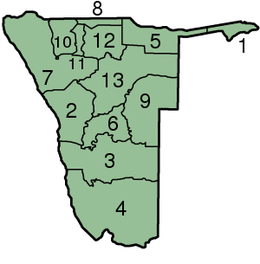
The administrative division of Namibia
is tabled by Delimitation Commissions and accepted or declined by the National Assembly
. The First Delimitation Commission chaired by Judge President Johan Strydom suggested in 1992 that Namibia be divided into 13 Regions, a number that has not been amended since.
Namibia
Namibia, officially the Republic of Namibia , is a country in southern Africa whose western border is the Atlantic Ocean. It shares land borders with Angola and Zambia to the north, Botswana to the east and South Africa to the south and east. It gained independence from South Africa on 21 March...
is tabled by Delimitation Commissions and accepted or declined by the National Assembly
National Assembly of Namibia
The National Assembly of Namibia is the lower chamber of the country's bicameral Parliament. It has a total of 78 members. 72 members are directly elected through a system of party-list proportional representation and serve five-year terms. Six additional members are appointed by the President.The...
. The First Delimitation Commission chaired by Judge President Johan Strydom suggested in 1992 that Namibia be divided into 13 Regions, a number that has not been amended since.
| # | Region | Capital | Population (2001) | Area (km²) | Population density persons/km² |
|---|---|---|---|---|---|
| 1 | Caprivi Region Caprivi Region Caprivi is one of the 13 regions of Namibia. It takes its name from the Caprivi Strip which in turn was named after Leo von Caprivi.-Geography:... |
Katima Mulilo Katima Mulilo Katima Mulilo is the capital of the Caprivi Strip, Namibia's far north–east extension into central Southern Africa. It comprises two electoral constituencies, Katima Mulilo Rural and Katima Mulilo Urban... |
79,826 | 14,528 | 5.5 |
| 2 | Erongo Region Erongo Region Erongo is one of the 13 regions of Namibia. It comprises the Swakopmund magisterial district up to the Ugab River and includes Walvis Bay, Omaruru and Karibib magisterial districts. This region is named after Erongo mountain, a well known landmark in Namibia and in this area... |
Swakopmund Swakopmund Swakopmund is a city on the coast of northwestern Namibia, west of Windhoek, Namibia's capital. It is the capital of the Erongo administrative district. As a seaside resort, the weather is cooler here in December to January so the territorial administration moves to Swakopmund for these months... |
100,663 | 63,579 | 1.6 |
| 3 | Hardap Region Hardap Region Hardap is one of the thirteen regions of Namibia. It is home to the Hardap Dam.Hardap stretches the entire width of Namibia, from the Atlantic Ocean in the west to Namibia's eastern national border. In the northeast, it borders the Kgalagadi District of Botswana, and in the southeast, it borders... |
Mariental Mariental -settlements:*Mariental, Germany, in the district of Helmstedt, Lower Saxony, Germany*Mariental, Namibia, in the Hardap Region, Namibia-other places:*Mariental, a valley near the Katzenbuckel located in Elztal, Germany... |
68,249 | 109,651 | 0.6 |
| 4 | Karas Region Karas Region The Karas Region is the southernmost region of Namibia. The name assigned to the region reflects the prominence of the Karas mountain range in its southern part... |
Keetmanshoop Keetmanshoop Keetmanshoop is a city in Karas Region, southern Namibia, lying on the Trans-Namib Railway from Windhoek to Upington in South Africa. It is named after Johann Keetman, a German industrialist and founder of the city.... |
69,329 | 161,215 | 0.5 |
| 5 | Kavango Region | Rundu Rundu Rundu is the capital of the Kavango Region, northern Namibia, on the border with Angola on the banks of the Okavango River about 1000 m above sea level. The place normally receives an annual average rainfall of , although in the 2010/2011 rainy season were measured.Rundu grows rapidly... |
202,694 | 48,463 | 4.0 |
| 6 | Khomas Region Khomas Region Khomas is one of the thirteen regions of Namibia. It contains the capital city Windhoek and provides for this reason superior transportation infrastructure. It has well-developed economical, financial, and trade sectors. Khomas Region occupies 4.5% of the land area of Namibia but has the highest... |
Windhoek Windhoek Windhoek is the capital and largest city of the Republic of Namibia. It is located in central Namibia in the Khomas Highland plateau area, at around above sea level. The 2001 census determined Windhoek's population was 233,529... |
250,262 | 37,007 | 7.0 |
| 7 | Kunene Region Kunene Region Kunene is one of the thirteen regions of Namibia and home to the Himba ethnic group. Compared to the rest of Namibia, it is relatively underdeveloped... |
Outjo Outjo Outjo is a city of 6,000 inhabitants in the Kunene Region of Namibia. It is the district capital of Outjo Constituency... |
68,735 | 115,293 | 0.6 |
| 8 | Ohangwena Region Ohangwena Region Ohangwena is one of the thirteen regions of Namibia. The northern and western parts of the region are the most densely populated of this essentially subsistence agricultural region in which small scale mahangu cultivation and the keeping of cattle form the predominant activities... |
Eenhana Eenhana Eenhana is the capital town of the Ohangwena Region, northern Namibia, on the border with Angola. Before Namibian independence it was a military centre of the South African Defence Force without public infrastructure. It was proclaimed a settlement in 1992, and a town in 1999... |
228,384 | 10,703 | 21.0 |
| 9 | Omaheke Region | Gobabis Gobabis Gobabis is a town in eastern Namibia. It is the regional capital of the Omaheke Region, and the district capital of the Gobabis electoral constituency. Gobabis is situated down the B6 motorway from Windhoek to Botswana. The town is from the Buitepos border post with Botswana, and serves as an... |
68,039 | 84,612 | 0.8 |
| 10 | Omusati Region | Outapi | 228,842 | 26,573 | 9.0 |
| 11 | Oshana Region | Oshakati Oshakati Oshakati is a town of 30,000 inhabitants in the Oshana Region of Namibia. It is the regional capital and was officially founded in July 1966. The city was used as a base of operations by the South African Defence Force during the South African Border War and Namibian War of Independence... |
161,916 | 8,653 | 19.0 |
| 12 | Oshikoto Region Oshikoto Region Oshikoto is one of the thirteen regions of Namibia. The northern part of the region is agricultural, whereas the main economic activities in the southern part are cattle rearing and mining... |
Omuthiya Omuthiya Omuthiya Gwiipundi is the capital of Oshikoto Region in northern Namibia, situated approximately from Etosha National Park. It has about 5,000 residents... |
161,007 | 38,653 | 4.1 |
| 13 | Otjozondjupa Region | Otjiwarongo Otjiwarongo Otjiwarongo is a city of 20,000 inhabitants in the Otjozondjupa Region of Namibia. It is the district capital of the Otjiwarongo electoral constituency and also the capital of Otjozondjupa.... |
135,384 | 105,185 | 1.3 |
Map of regions
| Regions of Namibia Namibia Namibia, officially the Republic of Namibia , is a country in southern Africa whose western border is the Atlantic Ocean. It shares land borders with Angola and Zambia to the north, Botswana to the east and South Africa to the south and east. It gained independence from South Africa on 21 March... |
|---|
 |
|