Discussion
Ask a question about 'Regions of Eritrea'
Start a new discussion about 'Regions of Eritrea'
Answer questions from other users
|
|
|
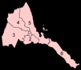
At the time of Independence in 1993
EritreaEritrea , officially the State of Eritrea, is a country in the Horn of Africa. Eritrea derives it's name from the Greek word Erethria, meaning 'red land'. The capital is Asmara. It is bordered by Sudan in the west, Ethiopia in the south, and Djibouti in the southeast...
was arranged into ten
provincesThe Provinces of Eritrea existed between Eritrea's incorporation as a Colony of Italy until the conversion of the provinces into administrative regions....
. These provinces were similar to the nine provinces operating during the colonial period. In 1996, these were consolidated into six regions (
zobas). The boundaries of these new regions are based on catchment basins.
Critics of this policy contend that the Government of Eritrea was erasing the historical fabric of Eritrea while proponents believe that these new Regional boundaries would ease historical land disputes. Furthermore proponents of this policy argue that basing boundaries on an important natural resource would ease the planning of its use.
Governance
Each region has a locally elected regional assembly while the local administrator is appointed by the President of Eritrea. During
CabinetThe Eritrean Cabinet of Ministers, are headed by the President of Eritrea, Isaias Afwerki, and run the day to day operations of the Government of Eritrea...
meetings the President also meets with the Regional Administrators who report on the activities of their regions.
The Regional Assemblies are charged with developing a budget for local programs and hearing the concerns of the local populations. Local programs included cultural events, infrastructure such as feeder roads, and to promote afforestation.
Regions
| Map number |
Province |
Postal abbreviation/ ISO codeISO 3166-2:ER is the entry for Eritrea in ISO 3166-2, part of the ISO 3166 standard published by the International Organization for Standardization , which defines codes for the names of the principal subdivisions of all countries coded in ISO 3166-1.Currently for Eritrea, ISO 3166-2 codes are...
|
Other abbreviations |
Capital |
| 4 |
Anseba |
ER-AN |
ZA |
KerenKeren is the second largest city in Eritrea. It is situated about 91 kilometers northwest of Asmara. The town serves as the capital of the Anseba region, and is home to the Bilen ethnic group.-History:...
|
| ዞባ ዓንሰባ |
| منطقة عنسبا |
| 1 |
Central |
ER-MA |
ZM |
AsmaraAsmara is the capital city and largest settlement in Eritrea, home to a population of around 579,000 people...
|
| ዞባ ማእከል |
| المنطقة المركزية |
| 3 |
Gash-Barka |
ER-GB |
ZGB |
BarentuBarentu is a town in south-western Eritrea, lying south of Agordat. It is mainly inhabited by the Nilotic Kunama people and Nara people. The Nara people leader Shekaray Agaba was the first to build the town umba arenku which it means the white water. It is located in the Gash-Barka Zone of...
|
| ዞባ ጋሽ ባርካ |
| منطقة القاش وبركا |
| 5 |
Northern Red Sea |
ER-SK |
ZNRS, ZSKB |
MassawaMassawa, also known as Mitsiwa Massawa, also known as Mitsiwa Massawa, also known as Mitsiwa (Ge'ez ምጽዋዕ , formerly ባጽዕ is a city on the Red Sea coast of Eritrea. An important port for many centuries, it was ruled by a succession of polities, including the Axumite Empire, the Umayyad Caliphate,...
|
| ዞባ ሰሜናዊ ቀይሕ ባሕሪ |
| منطقة البحر الأحمر الشمال |
| 2 |
Southern |
ER-DU |
ZD |
MendeferaMendefera , formerly Adi Ugri, is the capital of Zoba Debub in Eritrea. It is situated 54 kilometers south of the capital city Asmara. The name Mendefera derives from the high hill in the center of the city and is a source of pride to Eritreans...
|
| ዞባ ደቡብ |
| المنطقة الجنوبية |
| 6 |
Southern Red Sea |
ER-DK |
ZSRS, ZDKB |
Asseb |
| ዞባ ደቡባዊ ቀይሕ ባሕሪ |
| منطقة البحر الأحمر الجنوب |