
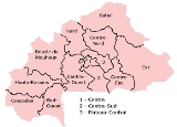
Regions of Burkina Faso
Encyclopedia
|
|
Burkina Faso
is divided into 13 administrative region
s:
List of Burkinabé regions (capitals in parenthesis):
These regions are divided into 45 provinces and subdivided into 301 communes.
|
Burkina Faso
Burkina Faso
Burkina Faso – also known by its short-form name Burkina – is a landlocked country in west Africa. It is surrounded by six countries: Mali to the north, Niger to the east, Benin to the southeast, Togo and Ghana to the south, and Côte d'Ivoire to the southwest.Its size is with an estimated...
is divided into 13 administrative region
Region
Region is most commonly found as a term used in terrestrial and astrophysics sciences also an area, notably among the different sub-disciplines of geography, studied by regional geographers. Regions consist of subregions that contain clusters of like areas that are distinctive by their uniformity...
s:
List of Burkinabé regions (capitals in parenthesis):
- Boucle du MouhounBoucle du Mouhoun RegionBoucle du Mouhoun is one of Burkina Faso's 13 administrative regions. It was created on 2 July 2001 and had a population of 1,434,847 in 2006. It is the 2nd most populous region in Burkina Faso after Centre Region, and contains 10.5% of all Burkinabé. The region's capital is Dédougou. Six provinces...
(DédougouDédougouDédougou is a city located in western Burkina Faso. It is the capital city of Mouhoun Province and Boucle du Mouhoun Region. The main ethnic groups are the Marka and the Bwa. The population of Dédougou was 37,793 in 2006; 18,778 were male and 19,015 were female. It is the 9th largest city in...
) - CascadesCascades RegionCascades is one of Burkina Faso's 13 administrative regions. It was created on 2 July 2001. The population of Cascades was 524,956 in 2006. It is the least populous region in Burkina Faso and contains 3.8% of all Burkinabé. The region's capital is Banfora. Two provinces, Comoé and Léraba, make up...
(BanforaBanforaBanfora is a city in south western Burkina Faso with a population of 63,300 people . It is the capital of the Comoe province. It has grown around the sugar cane industry. The city lies south-west of Bobo-Dioulasso, on the Abidjan – Ouagadougou railway. The main ethnic groups are the Gouin,the...
) - Centre (OuagadougouOuagadougouOuagadougou is the capital of Burkina Faso and the administrative, communications, cultural and economic center of the nation. It is also the country's largest city, with a population of 1,475,223 . The city's name is often shortened to Ouaga. The inhabitants are called ouagalais...
) - Centre-EstCentre-Est RegionCentre-Est is one of Burkina Faso's 13 administrative regions. The population of Centre-Est was 1,132,023 in 2006. The region's capital is Tenkodogo. Three provinces - Boulgou, Koulpélogo, and Kouritenga, make up the region. In 2005, this region was governed by Jacob Ouedraogo ....
(TenkodogoTenkodogoTenkodogo is the capital city of Boulgou Province and Centre-Est Region in Burkina Faso with a population of 40,839 . -History:Tenkodogo was the center of a city state of the Mossi Empire that dates back to 1120. The name Tenkodogo is derived from the Moore words tenga, meaning land and kodogo,...
) - Centre-NordCentre-Nord RegionCentre-Nord is one of thirteen administrative regions of Burkina Faso, a landlocked country in Africa. The population of Centre-Nord in 2006 was 1,203,073. The region's capital is Kaya. Three provinces - Bam, Namentenga, and Sanmatenga, make up the region....
(KayaKaya, Burkina FasoKaya is the eighth largest city in Burkina Faso, lying north east of Ouagadougou, to which it is connected by railway. It is a centre for weaving and tanning....
) - Centre-OuestCentre-Ouest RegionCentre-Ouest is one of Burkina Faso's 13 administrative regions. The population of Centre-Ouest was 1,183,473 in 2006. The region's capital is Koudougou. Four provinces - Boulkiemdé, Sanguié, Sissili, and Ziro, make up the region....
(KoudougouKoudougouKoudougou is a town in the province of Boulkiemdé, west of Ouagadougou, the capital of Burkina Faso. It is mainly inhabited by Mossi, and has 131,825 inhabitants, as of 2006...
) - Centre-SudCentre-Sud RegionCentre-Sud is one of Burkina Faso's 13 administrative regions. The population of Centre-Sud was 638,379 in 2006. The region's capital is Manga. Three provinces - Bazèga, Nahouri, and Zoundwéogo, make up the region....
(MangaManga, Burkina FasoManga is a town located in the province of Zoundwéogo in Burkina Faso. It is the capital of Zoundwéogo Province and Centre-Sud Region....
) - Est (Fada N'gourmaFada N'gourmaFada N'gourma, also written Fada-Ngourma, is a city in eastern Burkina Faso, lying east of Ouagadougou, in the Gourmantché area. It is the capital of the Gourma province. It was founded by Diaba Lompo as Bingo. It is known for its blanket and rug manufacturing. It is also famed for its honey...
) - Hauts-BassinsHauts-Bassins RegionHauts-Bassins is one of Burkina Faso's thirteen administrative regions. It was created on 2 July 2001. The population of Hauts-Bassins was 1,410,284 in 2006. The region's capital is Bobo Dioulasso. Three provinces make up the region - Houet, Kénédougou, and Tuy....
(Bobo Dioulasso) - Nord (OuahigouyaOuahigouyaOuahigouya is the most important town in northern Burkina Faso. It is the capital of the Yatenga Province and one of its subdivisions the Ouahigouya Department. It is also the biggest town in the Nord Region. It is the third largest city in the country with a population of 122,677. It is situated ...
) - Plateau-CentralPlateau-Central RegionPlateau-Central is one of Burkina Faso's 13 administrative regions. It was created on 2 July 2001 and had an estimated population of 647,516 in 2006. The region's capital is Ziniaré. Three provinces make up the region - Ganzourgou, Kourwéogo, and Oubritenga....
(ZiniaréZiniaréZiniaré is a town located in the province of Oubritenga in Burkina Faso. It is the capital of Oubritenga Province and Plateau-Central Region, and the birthplace of current President Blaise Compaoré.- External links :*...
) - SahelSahel RegionSahel is one of Burkina Faso's 13 administrative regions. It was created on 2 July 2001 and had a population of 808,928 in 2006. The region's capital is Dori. Four provinces make up the region - Oudalan, Séno, Soum, and Yagha....
(DoriDori, Burkina FasoDori is a town in northeastern Burkina Faso. It is located at around . It is the capital of Sahel Region and has a population of 17 675. The main ethnic group is the Fula .- Mines :...
) - Sud-Ouest (GaouaGaouaGaoua is a market town in southern Burkina Faso known for its superstitious values and customs.Population 26,023 Located in the red earth, green hills, and fast flowing streams of southwestern Burkina Faso, Gaoua is the capital of Poni Province and forms a sort of capital for the sacred rites and...
)
These regions are divided into 45 provinces and subdivided into 301 communes.
See also
- Provinces of Burkina FasoProvinces of Burkina FasoThe regions of Burkina Faso are divided into 45 administrative provinces.List of Burkinabé provinces :Balé Bam Banwa Bazèga Bougouriba Boulgou...
- Communes of Burkina Faso
- Geography of Burkina FasoGeography of Burkina FasoBurkina Faso is a landlocked Sahel country that shares borders with six nations. It lies between the Sahara Desert and the Gulf of Guinea, south of the loop of the Niger River. The land is green in the south, with forests and fruit trees, and desert in the north...
- ISO 3166-2:BFISO 3166-2:BFISO 3166-2:BF is the entry for Burkina Faso in ISO 3166-2, part of the ISO 3166 standard published by the International Organization for Standardization , which defines codes for the names of the principal subdivisions of all countries coded in ISO 3166-1.Currently for Burkina Faso, ISO 3166-2...