

Regional effects of global warming
Encyclopedia
Regional effects of global warming
are long-term significant changes in the expected patterns of average weather of a specific region due to global warming
. The world average temperature is rising due to the greenhouse effect
caused by increasing levels of greenhouse gases, especially carbon dioxide
. When the global temperature changes, the changes in climate are not expected to be uniform across the Earth. In particular, land areas change more quickly than oceans, and northern high latitudes change more quickly than the tropics
, and the margins of biome
regions change faster than do their cores.
Regional effects of global warming vary in nature. Some are the result of a generalised global change, such as rising temperature, resulting in local effects, such as melting ice. In other cases, a change may be related to a change in a particular ocean current or weather system. In such cases, the regional effect may be disproportionate and will not necessarily follow the global trend.
There are three major ways in which global warming will make changes to regional climate: melting or forming ice, changing the hydrological cycle (of evaporation
and precipitation
) and changing currents in the ocean
s and air flows in the atmosphere. The coast
can also be considered a region, and will suffer severe impacts from sea level rise.
, Africa
, small islands and Asia
n megadelta
s are regions that are likely to be especially affected by future climate change. Within other areas, some people are particularly at risk from future climate change, such as the poor, young child
ren and the elderly.
The Arctic is likely to be especially affected by climate change because of the high projected rate of regional warming and associated impacts. Temperature projections for the Arctic region were assessed by Anisimov et al. (2007). These suggested areally averaged warming of about 2 °C to 9 °C by the year 2100. The range reflects different projections made by different climate model
s, run with different forcing scenarios
. Radiative forcing
is a measure of the effect of natural and human activities on the climate. Different forcing scenarios reflect, for example, different projections of future human greenhouse gas
emissions.
Africa is likely to be the continent most vulnerable to climate change. With high confidence, Boko et al. (2007) projected that in many African countries and regions, agricultural production and food security
would likely be severely compromised by climate change and climate variability.
On small islands, sea level rise is expected to exacerbate inundation, erosion
and other coastal hazards, and threaten vital infrastructure
, human settlements and facilities that support the livelihood of island communities. In the coastal zone of Asia, there are 11 megadeltas with an area greater than 10,000 km2. These megadeltas are homes to millions of people, and contain diverse ecosystem
s. Climate change and sea level rise could increase the frequency and level of inundation of Asian megadeltas due to storm surge
s and floods from river
drainage.
. Some of the coldest places on Earth, such as the dry valleys of Antarctica, lack significant ice or snow coverage due to a lack of snow. Sea ice however maybe formed simply by low temperature, although precipitation may influence its stability by changing albedo
, providing an insulating covering of snow and effecting heat transfer. Global warming has the capacity to alter both precipitation and temperature, resulting in significant changes to ice cover. Furthermore, the behaviour of ice sheets, ice caps and glaciers is altered by changes in temperature and precipitation, particularly as regards the behaviour of water flowing into and through the ice.
 Recent projections of sea ice
loss suggest that the Arctic ocean
will likely be free of summer sea ice
sometime between 2059 and 2078.
Models showing decreasing sea ice also show a corresponding decrease in polar bear habitat. Some scientists see the polar bear as a species which will be affected first and most severely by global warming because it is a top-level predator in the Arctic, which is projected to warm more than the global average. Recent reports show polar bears resorting to cannibalism, and scientists state that these are the only instances that they have observed of polar bears stalking and killing one another for food.
 The Antarctic peninsula
has lost a number of ice shelves
recently. These are large areas of floating ice which are fed by glaciers. Many are the size of a small country. The sudden collapse of the Larsen B ice shelf
in 2002 took 5 weeks or less and may have been due to global warming. Larsen B had previously been stable for up to 12,000 years.
Concern has been expressed about the stability of the West Antarctic ice sheet
. A collapse of the West Antarctic ice sheet could occur "within 300 years [as] a worst-case scenario. Rapid sea-level rise (>1 m per century) is more likely to come from the WAIS than from the [Greenland ice sheet]."
of icebergs as well as by melting of ice, any such processes tend to accelerate the loss of the ice sheet.
The IPCC suggest that Greenland will become ice free at around 5C over pre-industrial levels, but subsequent research comparing data from the Eemian period suggests that the ice sheet will remain at least in part at these temperatures. The volume of ice in the Greenland
sheet is sufficient to cause a global sea level rise of 7 meters. It would take 3,000 years to completely melt the Greenland ice sheet. This figure was derived from the assumed levels of greenhouse gases over the duration of the experiment. In reality, these greenhouse gas levels are of course affected by future emissions and may differ from the assumptions made in the model.
. Loss of these glaciers will have dramatic effects on the downstream region, increasing the risk of drought as lower flows of meltwater
reduce summer river flows unless summer precipitation
increases. Altered patterns of flooding can also affect soil fertility.
The Tibetan Plateau
contains the world's third-largest store of ice. Qin Dahe, the former head of the China Meteorological Administration
, said that the recent fast pace of melting and warmer temperatures will be good for agriculture and tourism in the short term; but issued a strong warning:
cover much of the Arctic. In many areas, permafrost is melting, leading to the formation of a bog
gy, undulating landscape filled with thermokarst
lakes and distinctive patterns of drunken trees
. The process of permafrost melting is complex and poorly understood since existing models do not include feedback effects such as the heat generated by decomposition.
Arctic permafrost soils are estimated to store twice as much carbon as is currently present in the atmosphere in
the form of CO2. Warming in the Arctic is causing increased emissions of CO2 and Methane
(CH4).
 Much of the effect of global warming
is felt through its influence on rain and snow
. Regions may become wetter, drier, or may experience changes in the intensity of precipitation - such as moving from a damp climate to one defined by a mixture of floods and droughts. These changes may have a very severe impact on both the natural world and human civilisation, as both naturally occurring and farmed plants experience regional climate change that is beyond their ability to tolerate.
may be reduced by 70% if global warming
continues unchecked, due to regional precipitation
changes that result from weakening of large-scale tropical circulation.
is expected as a result of global warming, due to expansion of the Hadley Cell
.
 Global sea level is currently rising
due to the thermal expansion
of water
in the ocean
s and the addition of water from ice sheets. Because of this, there low-lying coastal areas, many of which are heavily populated
, are at risk of flooding.
Areas threatened by current sea level rise
include Tuvalu
and the Maldives
. Regions that are prone to storm surge
s, such as London
, are also threatened.
With very high confidence, IPCC (2007) projected that by the 2080s, many millions more people would experience floods every year due to sea level rise.
The numbers affected were projected to be largest in the densely populated and low-lying megadeltas of Asia and Africa. Small islands were judged to be especially vulnerable.
may result in relative cooling of the North Atlantic region by up to 8C in certain locations. Recent research suggests that this process is not currently underway.
s, and multiple independent data sets indicate that the warming trend due to well-mixed greenhouse gases should be faster in the troposphere
than at the surface.
Effects of global warming
This article is about the effects of global warming and climate change. The effects, or impacts, of climate change may be physical, ecological, social or economic. Evidence of observed climate change includes the instrumental temperature record, rising sea levels, and decreased snow cover in the...
are long-term significant changes in the expected patterns of average weather of a specific region due to global warming
Global warming
Global warming refers to the rising average temperature of Earth's atmosphere and oceans and its projected continuation. In the last 100 years, Earth's average surface temperature increased by about with about two thirds of the increase occurring over just the last three decades...
. The world average temperature is rising due to the greenhouse effect
Greenhouse effect
The greenhouse effect is a process by which thermal radiation from a planetary surface is absorbed by atmospheric greenhouse gases, and is re-radiated in all directions. Since part of this re-radiation is back towards the surface, energy is transferred to the surface and the lower atmosphere...
caused by increasing levels of greenhouse gases, especially carbon dioxide
Carbon dioxide
Carbon dioxide is a naturally occurring chemical compound composed of two oxygen atoms covalently bonded to a single carbon atom...
. When the global temperature changes, the changes in climate are not expected to be uniform across the Earth. In particular, land areas change more quickly than oceans, and northern high latitudes change more quickly than the tropics
Tropics
The tropics is a region of the Earth surrounding the Equator. It is limited in latitude by the Tropic of Cancer in the northern hemisphere at approximately N and the Tropic of Capricorn in the southern hemisphere at S; these latitudes correspond to the axial tilt of the Earth...
, and the margins of biome
Biome
Biomes are climatically and geographically defined as similar climatic conditions on the Earth, such as communities of plants, animals, and soil organisms, and are often referred to as ecosystems. Some parts of the earth have more or less the same kind of abiotic and biotic factors spread over a...
regions change faster than do their cores.
Regional effects of global warming vary in nature. Some are the result of a generalised global change, such as rising temperature, resulting in local effects, such as melting ice. In other cases, a change may be related to a change in a particular ocean current or weather system. In such cases, the regional effect may be disproportionate and will not necessarily follow the global trend.
There are three major ways in which global warming will make changes to regional climate: melting or forming ice, changing the hydrological cycle (of evaporation
Evaporation
Evaporation is a type of vaporization of a liquid that occurs only on the surface of a liquid. The other type of vaporization is boiling, which, instead, occurs on the entire mass of the liquid....
and precipitation
Precipitation (meteorology)
In meteorology, precipitation In meteorology, precipitation In meteorology, precipitation (also known as one of the classes of hydrometeors, which are atmospheric water phenomena is any product of the condensation of atmospheric water vapor that falls under gravity. The main forms of precipitation...
) and changing currents in the ocean
Ocean current
An ocean current is a continuous, directed movement of ocean water generated by the forces acting upon this mean flow, such as breaking waves, wind, Coriolis effect, cabbeling, temperature and salinity differences and tides caused by the gravitational pull of the Moon and the Sun...
s and air flows in the atmosphere. The coast
Coast
A coastline or seashore is the area where land meets the sea or ocean. A precise line that can be called a coastline cannot be determined due to the dynamic nature of tides. The term "coastal zone" can be used instead, which is a spatial zone where interaction of the sea and land processes occurs...
can also be considered a region, and will suffer severe impacts from sea level rise.
Especially affected regions
The ArcticArctic
The Arctic is a region located at the northern-most part of the Earth. The Arctic consists of the Arctic Ocean and parts of Canada, Russia, Greenland, the United States, Norway, Sweden, Finland, and Iceland. The Arctic region consists of a vast, ice-covered ocean, surrounded by treeless permafrost...
, Africa
Africa
Africa is the world's second largest and second most populous continent, after Asia. At about 30.2 million km² including adjacent islands, it covers 6% of the Earth's total surface area and 20.4% of the total land area...
, small islands and Asia
Asia
Asia is the world's largest and most populous continent, located primarily in the eastern and northern hemispheres. It covers 8.7% of the Earth's total surface area and with approximately 3.879 billion people, it hosts 60% of the world's current human population...
n megadelta
River delta
A delta is a landform that is formed at the mouth of a river where that river flows into an ocean, sea, estuary, lake, reservoir, flat arid area, or another river. Deltas are formed from the deposition of the sediment carried by the river as the flow leaves the mouth of the river...
s are regions that are likely to be especially affected by future climate change. Within other areas, some people are particularly at risk from future climate change, such as the poor, young child
Child
Biologically, a child is generally a human between the stages of birth and puberty. Some vernacular definitions of a child include the fetus, as being an unborn child. The legal definition of "child" generally refers to a minor, otherwise known as a person younger than the age of majority...
ren and the elderly.
The Arctic is likely to be especially affected by climate change because of the high projected rate of regional warming and associated impacts. Temperature projections for the Arctic region were assessed by Anisimov et al. (2007). These suggested areally averaged warming of about 2 °C to 9 °C by the year 2100. The range reflects different projections made by different climate model
Climate model
Climate models use quantitative methods to simulate the interactions of the atmosphere, oceans, land surface, and ice. They are used for a variety of purposes from study of the dynamics of the climate system to projections of future climate...
s, run with different forcing scenarios
Climate change scenario
This article is about climate change scenarios. Socioeconomic scenarios are used by analysts to make projections of future greenhouse gas emissions and to assess future vulnerability to climate change...
. Radiative forcing
Radiative forcing
In climate science, radiative forcing is generally defined as the change in net irradiance between different layers of the atmosphere. Typically, radiative forcing is quantified at the tropopause in units of watts per square meter. A positive forcing tends to warm the system, while a negative...
is a measure of the effect of natural and human activities on the climate. Different forcing scenarios reflect, for example, different projections of future human greenhouse gas
Greenhouse gas
A greenhouse gas is a gas in an atmosphere that absorbs and emits radiation within the thermal infrared range. This process is the fundamental cause of the greenhouse effect. The primary greenhouse gases in the Earth's atmosphere are water vapor, carbon dioxide, methane, nitrous oxide, and ozone...
emissions.
Africa is likely to be the continent most vulnerable to climate change. With high confidence, Boko et al. (2007) projected that in many African countries and regions, agricultural production and food security
Food security
Food security refers to the availability of food and one's access to it. A household is considered food-secure when its occupants do not live in hunger or fear of starvation. According to the World Resources Institute, global per capita food production has been increasing substantially for the past...
would likely be severely compromised by climate change and climate variability.
On small islands, sea level rise is expected to exacerbate inundation, erosion
Erosion
Erosion is when materials are removed from the surface and changed into something else. It only works by hydraulic actions and transport of solids in the natural environment, and leads to the deposition of these materials elsewhere...
and other coastal hazards, and threaten vital infrastructure
Infrastructure
Infrastructure is basic physical and organizational structures needed for the operation of a society or enterprise, or the services and facilities necessary for an economy to function...
, human settlements and facilities that support the livelihood of island communities. In the coastal zone of Asia, there are 11 megadeltas with an area greater than 10,000 km2. These megadeltas are homes to millions of people, and contain diverse ecosystem
Ecosystem
An ecosystem is a biological environment consisting of all the organisms living in a particular area, as well as all the nonliving , physical components of the environment with which the organisms interact, such as air, soil, water and sunlight....
s. Climate change and sea level rise could increase the frequency and level of inundation of Asian megadeltas due to storm surge
Storm surge
A storm surge is an offshore rise of water associated with a low pressure weather system, typically tropical cyclones and strong extratropical cyclones. Storm surges are caused primarily by high winds pushing on the ocean's surface. The wind causes the water to pile up higher than the ordinary sea...
s and floods from river
River
A river is a natural watercourse, usually freshwater, flowing towards an ocean, a lake, a sea, or another river. In a few cases, a river simply flows into the ground or dries up completely before reaching another body of water. Small rivers may also be called by several other names, including...
drainage.
Ice-cover changes
Permanent ice cover on land is a result of a combination of low peak temperatures and sufficient precipitationPrecipitation (meteorology)
In meteorology, precipitation In meteorology, precipitation In meteorology, precipitation (also known as one of the classes of hydrometeors, which are atmospheric water phenomena is any product of the condensation of atmospheric water vapor that falls under gravity. The main forms of precipitation...
. Some of the coldest places on Earth, such as the dry valleys of Antarctica, lack significant ice or snow coverage due to a lack of snow. Sea ice however maybe formed simply by low temperature, although precipitation may influence its stability by changing albedo
Albedo
Albedo , or reflection coefficient, is the diffuse reflectivity or reflecting power of a surface. It is defined as the ratio of reflected radiation from the surface to incident radiation upon it...
, providing an insulating covering of snow and effecting heat transfer. Global warming has the capacity to alter both precipitation and temperature, resulting in significant changes to ice cover. Furthermore, the behaviour of ice sheets, ice caps and glaciers is altered by changes in temperature and precipitation, particularly as regards the behaviour of water flowing into and through the ice.
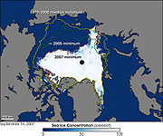
Arctic sea ice
Sea ice
Sea ice is largely formed from seawater that freezes. Because the oceans consist of saltwater, this occurs below the freezing point of pure water, at about -1.8 °C ....
loss suggest that the Arctic ocean
Arctic Ocean
The Arctic Ocean, located in the Northern Hemisphere and mostly in the Arctic north polar region, is the smallest and shallowest of the world's five major oceanic divisions...
will likely be free of summer sea ice
Sea ice
Sea ice is largely formed from seawater that freezes. Because the oceans consist of saltwater, this occurs below the freezing point of pure water, at about -1.8 °C ....
sometime between 2059 and 2078.
Models showing decreasing sea ice also show a corresponding decrease in polar bear habitat. Some scientists see the polar bear as a species which will be affected first and most severely by global warming because it is a top-level predator in the Arctic, which is projected to warm more than the global average. Recent reports show polar bears resorting to cannibalism, and scientists state that these are the only instances that they have observed of polar bears stalking and killing one another for food.
Antarctica
Antarctic Peninsula
The Antarctic Peninsula is the northernmost part of the mainland of Antarctica. It extends from a line between Cape Adams and a point on the mainland south of Eklund Islands....
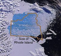
has lost a number of ice shelves
Ice shelf
An ice shelf is a thick, floating platform of ice that forms where a glacier or ice sheet flows down to a coastline and onto the ocean surface. Ice shelves are only found in Antarctica, Greenland and Canada. The boundary between the floating ice shelf and the grounded ice that feeds it is called...
recently. These are large areas of floating ice which are fed by glaciers. Many are the size of a small country. The sudden collapse of the Larsen B ice shelf
Ice shelf
An ice shelf is a thick, floating platform of ice that forms where a glacier or ice sheet flows down to a coastline and onto the ocean surface. Ice shelves are only found in Antarctica, Greenland and Canada. The boundary between the floating ice shelf and the grounded ice that feeds it is called...
in 2002 took 5 weeks or less and may have been due to global warming. Larsen B had previously been stable for up to 12,000 years.
Concern has been expressed about the stability of the West Antarctic ice sheet
West Antarctic Ice Sheet
The West Antarctic Ice Sheet is the segment of the continental ice sheet that covers West Antarctica, the portion of Antarctica on the side of the Transantarctic Mountains which lies in the Western Hemisphere. The WAIS is classified as a marine-based ice sheet, meaning that its bed lies well...
. A collapse of the West Antarctic ice sheet could occur "within 300 years [as] a worst-case scenario. Rapid sea-level rise (>1 m per century) is more likely to come from the WAIS than from the [Greenland ice sheet]."
Greenland
As the Greenland ice sheet loses mass from calvingIce calving
Ice calving, also known as glacier calving or iceberg calving, is a form of ice ablation or ice disruption. It is the sudden release and breaking away of a mass of ice from a glacier, iceberg, ice front, ice shelf, or crevasse...
of icebergs as well as by melting of ice, any such processes tend to accelerate the loss of the ice sheet.
The IPCC suggest that Greenland will become ice free at around 5C over pre-industrial levels, but subsequent research comparing data from the Eemian period suggests that the ice sheet will remain at least in part at these temperatures. The volume of ice in the Greenland
Greenland
Greenland is an autonomous country within the Kingdom of Denmark, located between the Arctic and Atlantic Oceans, east of the Canadian Arctic Archipelago. Though physiographically a part of the continent of North America, Greenland has been politically and culturally associated with Europe for...
sheet is sufficient to cause a global sea level rise of 7 meters. It would take 3,000 years to completely melt the Greenland ice sheet. This figure was derived from the assumed levels of greenhouse gases over the duration of the experiment. In reality, these greenhouse gas levels are of course affected by future emissions and may differ from the assumptions made in the model.
Glaciers
Glacier retreat not only affects the communities and ecosystems around the actual glacier, but the entire downstream region. The most notable example of this is in India, where river systems such as the Indus and Ganges are ultimately fed by glacial meltwater from the HimalayasHimalayas
The Himalaya Range or Himalaya Mountains Sanskrit: Devanagari: हिमालय, literally "abode of snow"), usually called the Himalayas or Himalaya for short, is a mountain range in Asia, separating the Indian subcontinent from the Tibetan Plateau...
. Loss of these glaciers will have dramatic effects on the downstream region, increasing the risk of drought as lower flows of meltwater
Meltwater
Meltwater is the water released by the melting of snow or ice, including glacial ice and ice shelfs over oceans. Meltwater is often found in the ablation zone of glaciers, where the rate of snow cover is reducing...
reduce summer river flows unless summer precipitation
Precipitation (meteorology)
In meteorology, precipitation In meteorology, precipitation In meteorology, precipitation (also known as one of the classes of hydrometeors, which are atmospheric water phenomena is any product of the condensation of atmospheric water vapor that falls under gravity. The main forms of precipitation...
increases. Altered patterns of flooding can also affect soil fertility.
The Tibetan Plateau
Tibetan Plateau
The Tibetan Plateau , also known as the Qinghai–Tibetan Plateau is a vast, elevated plateau in Central Asia covering most of the Tibet Autonomous Region and Qinghai, in addition to smaller portions of western Sichuan, southwestern Gansu, and northern Yunnan in Western China and Ladakh in...
contains the world's third-largest store of ice. Qin Dahe, the former head of the China Meteorological Administration
China Meteorological Administration
The China Meteorological Administration , headquartered in Beijing, is the national weather service for the People's Republic of China.-History:...
, said that the recent fast pace of melting and warmer temperatures will be good for agriculture and tourism in the short term; but issued a strong warning:
"Temperatures are rising four times faster than elsewhere in China, and the Tibetan glaciers are retreating at a higher speed than in any other part of the world.... In the short term, this will cause lakes to expand and bring floods and mudflows. . . . In the long run, the glaciers are vital lifelines for Asian rivers, including the Indus and the Ganges. Once they vanish, water supplies in those regions will be in peril."
Permafrost regions
Regions of permafrostPermafrost
In geology, permafrost, cryotic soil or permafrost soil is soil at or below the freezing point of water for two or more years. Ice is not always present, as may be in the case of nonporous bedrock, but it frequently occurs and it may be in amounts exceeding the potential hydraulic saturation of...
cover much of the Arctic. In many areas, permafrost is melting, leading to the formation of a bog
Bog
A bog, quagmire or mire is a wetland that accumulates acidic peat, a deposit of dead plant material—often mosses or, in Arctic climates, lichens....
gy, undulating landscape filled with thermokarst
Thermokarst
Thermokarst is a land surface characterised by very irregular surfaces of marshy hollows and small hummocks formed as ice-rich permafrost thaws, that occurs in Arctic areas, and on a smaller scale in mountainous areas such as the Himalayas and the Swiss Alps...
lakes and distinctive patterns of drunken trees
Drunken trees
Drunken trees, tilted trees, or a drunken forest, is a stand of trees displaced from their normal vertical alignment.This most commonly occurs in northern subarctic taiga forests of Black Spruce under which discontinuous permafrost or ice wedges have melted, causing trees to tilt at various...
. The process of permafrost melting is complex and poorly understood since existing models do not include feedback effects such as the heat generated by decomposition.
Arctic permafrost soils are estimated to store twice as much carbon as is currently present in the atmosphere in
the form of CO2. Warming in the Arctic is causing increased emissions of CO2 and Methane
Methane
Methane is a chemical compound with the chemical formula . It is the simplest alkane, the principal component of natural gas, and probably the most abundant organic compound on earth. The relative abundance of methane makes it an attractive fuel...
(CH4).
Precipitation and vegetation changes
Global warming
Global warming refers to the rising average temperature of Earth's atmosphere and oceans and its projected continuation. In the last 100 years, Earth's average surface temperature increased by about with about two thirds of the increase occurring over just the last three decades...
is felt through its influence on rain and snow
Precipitation (meteorology)
In meteorology, precipitation In meteorology, precipitation In meteorology, precipitation (also known as one of the classes of hydrometeors, which are atmospheric water phenomena is any product of the condensation of atmospheric water vapor that falls under gravity. The main forms of precipitation...
. Regions may become wetter, drier, or may experience changes in the intensity of precipitation - such as moving from a damp climate to one defined by a mixture of floods and droughts. These changes may have a very severe impact on both the natural world and human civilisation, as both naturally occurring and farmed plants experience regional climate change that is beyond their ability to tolerate.
Amazon
One modeling study suggested that the extent of the Amazon rainforestAmazon Rainforest
The Amazon Rainforest , also known in English as Amazonia or the Amazon Jungle, is a moist broadleaf forest that covers most of the Amazon Basin of South America...
may be reduced by 70% if global warming
Global warming
Global warming refers to the rising average temperature of Earth's atmosphere and oceans and its projected continuation. In the last 100 years, Earth's average surface temperature increased by about with about two thirds of the increase occurring over just the last three decades...
continues unchecked, due to regional precipitation
Precipitation (meteorology)
In meteorology, precipitation In meteorology, precipitation In meteorology, precipitation (also known as one of the classes of hydrometeors, which are atmospheric water phenomena is any product of the condensation of atmospheric water vapor that falls under gravity. The main forms of precipitation...
changes that result from weakening of large-scale tropical circulation.
Sahara
Some studies suggest that the Sahara desert have been more vegetated during the warmer Mid-Holocene period, and that future warming may result in similar patterns.Sahel
Climate models which realistically model the West African Monsoon predict "a doubling of the number of anomalously dry years [in the Sahel] by the end of the century".Desert expansion
Expansion of subtropical desertsDéserts
Déserts is a piece by Edgard Varèse for brass , percussion , piano, and tape. Percussion instruments are exploited for their resonant potential, rather than used solely as accompaniment...
is expected as a result of global warming, due to expansion of the Hadley Cell
Hadley cell
The Hadley cell, named after George Hadley, is a circulation pattern that dominates the tropical atmosphere, with rising motion near the equator, poleward flow 10–15 kilometers above the surface, descending motion in the subtropics, and equatorward flow near the surface...
.
Coastal regions
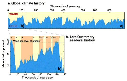
Current sea level rise
Current sea level rise potentially impacts human populations and the wider natural environment . Global average sea level rose at an average rate of around 1.8 mm per year over 1961 to 2003 and at an average rate of about 3.1 mm per year from 1993 to 2003...
due to the thermal expansion
Thermal expansion
Thermal expansion is the tendency of matter to change in volume in response to a change in temperature.When a substance is heated, its particles begin moving more and thus usually maintain a greater average separation. Materials which contract with increasing temperature are rare; this effect is...
of water
Water
Water is a chemical substance with the chemical formula H2O. A water molecule contains one oxygen and two hydrogen atoms connected by covalent bonds. Water is a liquid at ambient conditions, but it often co-exists on Earth with its solid state, ice, and gaseous state . Water also exists in a...
in the ocean
Ocean
An ocean is a major body of saline water, and a principal component of the hydrosphere. Approximately 71% of the Earth's surface is covered by ocean, a continuous body of water that is customarily divided into several principal oceans and smaller seas.More than half of this area is over 3,000...
s and the addition of water from ice sheets. Because of this, there low-lying coastal areas, many of which are heavily populated
Population density
Population density is a measurement of population per unit area or unit volume. It is frequently applied to living organisms, and particularly to humans...
, are at risk of flooding.
Areas threatened by current sea level rise
Current sea level rise
Current sea level rise potentially impacts human populations and the wider natural environment . Global average sea level rose at an average rate of around 1.8 mm per year over 1961 to 2003 and at an average rate of about 3.1 mm per year from 1993 to 2003...
include Tuvalu
Tuvalu
Tuvalu , formerly known as the Ellice Islands, is a Polynesian island nation located in the Pacific Ocean, midway between Hawaii and Australia. Its nearest neighbours are Kiribati, Nauru, Samoa and Fiji. It comprises four reef islands and five true atolls...
and the Maldives
Maldives
The Maldives , , officially Republic of Maldives , also referred to as the Maldive Islands, is an island nation in the Indian Ocean formed by a double chain of twenty-six atolls oriented north-south off India's Lakshadweep islands, between Minicoy Island and...
. Regions that are prone to storm surge
Storm surge
A storm surge is an offshore rise of water associated with a low pressure weather system, typically tropical cyclones and strong extratropical cyclones. Storm surges are caused primarily by high winds pushing on the ocean's surface. The wind causes the water to pile up higher than the ordinary sea...
s, such as London
London
London is the capital city of :England and the :United Kingdom, the largest metropolitan area in the United Kingdom, and the largest urban zone in the European Union by most measures. Located on the River Thames, London has been a major settlement for two millennia, its history going back to its...
, are also threatened.
With very high confidence, IPCC (2007) projected that by the 2080s, many millions more people would experience floods every year due to sea level rise.
The numbers affected were projected to be largest in the densely populated and low-lying megadeltas of Asia and Africa. Small islands were judged to be especially vulnerable.
North Atlantic region
It has been suggested that a shutdown of the Atlantic thermohaline circulationThermohaline circulation
The term thermohaline circulation refers to a part of the large-scale ocean circulation that is driven by global density gradients created by surface heat and freshwater fluxes....
may result in relative cooling of the North Atlantic region by up to 8C in certain locations. Recent research suggests that this process is not currently underway.
Tropical surface and troposphere temperatures
In the tropics, basic physical considerations, climate modelClimate model
Climate models use quantitative methods to simulate the interactions of the atmosphere, oceans, land surface, and ice. They are used for a variety of purposes from study of the dynamics of the climate system to projections of future climate...
s, and multiple independent data sets indicate that the warming trend due to well-mixed greenhouse gases should be faster in the troposphere
Troposphere
The troposphere is the lowest portion of Earth's atmosphere. It contains approximately 80% of the atmosphere's mass and 99% of its water vapor and aerosols....
than at the surface.
See also
- Arctic methane releaseArctic methane releaseArctic methane release is the release of methane from seas and soils in permafrost regions of the Arctic, as part of a more general release of carbon from these soils and seas. Whilst a long-term natural process, it may be exacerbated by global warming. This results in a weak positive feedback...
- Climate change in the Arctic
- Intertropical Convergence ZoneIntertropical Convergence ZoneThe Intertropical Convergence Zone , known by sailors as The Doldrums, is the area encircling the earth near the equator where winds originating in the northern and southern hemispheres come together....
(ITCZ) - Sea level rise
- Shutdown of thermohaline circulationShutdown of thermohaline circulationShutdown or slowdown of the thermohaline circulation is a postulated effect of global warming.There is some speculation that global warming could, via a shutdown or slowdown of the thermohaline circulation, trigger localised cooling in the North Atlantic and lead to cooling, or lesser warming, in...
- Effects of global warmingEffects of global warmingThis article is about the effects of global warming and climate change. The effects, or impacts, of climate change may be physical, ecological, social or economic. Evidence of observed climate change includes the instrumental temperature record, rising sea levels, and decreased snow cover in the...
External links
- IPCC Special Report on The Regional Impacts of Climate Change: An Assessment of Vulnerability
- IPCC AR4 Regional Climate Projections