
Redwood River
Encyclopedia
The Redwood River is a tributary
of the Minnesota River
, 127 miles (205 km) long, in southwestern Minnesota
in the United States
. Via the Minnesota River, it is part of the watershed
of the Mississippi River
, draining an area of 705 square miles (1,826 km²) in an agricultural region. The river's name is believed to refer to the reddish bark of dogwood
growing along streams in the region.
The source of the Redwood River is in Aetna Township
in northeastern Pipestone County
, approximately four miles (6 km) west of Ruthton
, on the Coteau des Prairies
, a morainic
plateau
dividing the Mississippi and Missouri River
watersheds. It flows initially eastwardly as an intermittent stream, through Ruthton and into northwestern Murray County
, then northwardly into Lyon County
, where it turns northeastward and flows through Russell
, Lynd
, and Marshall
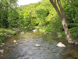
. Between Russell and Marshall, the river flows off the Coteau in a wooded valley, dropping 300 feet (90 m) in 15 miles (24 km); Camden State Park
is located along this stretch of the river.
 Downstream of Marshall the Redwood flows through a flat till plain
and turns eastward into Redwood County
, passing Vesta
and Seaforth
; sections of the river in this stretch have been straightened to form agricultural ditch
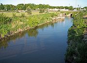
es. In Redwood Falls
the river enters the wooded valley of the Minnesota River, falling 100 feet (30 m) in one mile (2 km) over granite ledges in Alexander Ramsey City Park; it flows into the Minnesota shortly downstream of the city. A dam forming Redwood Lake in Redwood Falls was formerly used for hydroelectricity
generation and is presently maintained for recreational use.
Principal tributaries of the Redwood River include Coon Creek, 37 miles (60 km) long, which flows from Lake Benton in Lincoln County
westwardly to Russell in Lyon County; Three Mile Creek, 50 miles (81 km) long, which rises in Lincoln County and flows northeastwardly and southeastwardly through Lyon County, joining the Redwood downstream of Marshall; and Ramsey Creek, 10 miles (16 km) long, which flows over a waterfall in Ramsey City Park in Redwood Falls.
The Redwood River is a tributary
of the Minnesota River
, 127 miles (205 km) long, in southwestern Minnesota
in the United States
. Via the Minnesota River, it is part of the watershed
of the Mississippi River
, draining an area of 705 square miles (1,826 km²) in an agricultural region. The river's name is believed to refer to the reddish bark of dogwood
growing along streams in the region.
The source of the Redwood River is in Aetna Township
in northeastern Pipestone County
, approximately four miles (6 km) west of Ruthton
, on the Coteau des Prairies
, a morainic
plateau
dividing the Mississippi and Missouri River
watersheds. It flows initially eastwardly as an intermittent stream, through Ruthton and into northwestern Murray County
, then northwardly into Lyon County
, where it turns northeastward and flows through Russell
, Lynd
, and Marshall
. Between Russell and Marshall, the river flows off the Coteau in a wooded valley, dropping 300 feet (90 m) in 15 miles (24 km); Camden State Park
is located along this stretch of the river.
Downstream of Marshall the Redwood flows through a flat till plain
and turns eastward into Redwood County
, passing Vesta
and Seaforth
; sections of the river in this stretch have been straightened to form agricultural ditch
es. In Redwood Falls
the river enters the wooded valley of the Minnesota River, falling 100 feet (30 m) in one mile (2 km) over granite ledges in Alexander Ramsey City Park; it flows into the Minnesota shortly downstream of the city. A dam forming Redwood Lake in Redwood Falls was formerly used for hydroelectricity
generation and is presently maintained for recreational use.
Principal tributaries of the Redwood River include Coon Creek, 37 miles (60 km) long, which flows from Lake Benton in Lincoln County
westwardly to Russell in Lyon County; Three Mile Creek, 50 miles (81 km) long, which rises in Lincoln County and flows northeastwardly and southeastwardly through Lyon County, joining the Redwood downstream of Marshall; and Ramsey Creek, 10 miles (16 km) long, which flows over a waterfall in Ramsey City Park in Redwood Falls.
Approximately 82% of the land in the Redwood River watershed is used for agriculture, primarily for the cultivation of corn
and soybean
s. Hundreds of miles of streams in the watershed have been converted to agricultural ditches.
's stream gauge
near Redwood Falls, 8.5 miles (13.7 km) upstream from the river's mouth, the annual mean flow of the river between 1909 and 2005 was 153 cubic feet per second (4 m³/s). The highest recorded flow during the period was 19,700 ft³/s (558 m³/s) on June 18, 1957. Readings of zero were recorded on numerous days in 1940 and 1959.
At an upstream gauge near Marshall, the annual mean flow between 1940 and 2005 was 69.5 ft³/s (2 m³/s). The highest recorded flow during the period was 6,380 ft³/s (181 m³/s) on May 9, 1993. Readings of zero were recorded on numerous days during several years.
Tributary
A tributary or affluent is a stream or river that flows into a main stem river or a lake. A tributary does not flow directly into a sea or ocean...
of the Minnesota River
Minnesota River
The Minnesota River is a tributary of the Mississippi River, approximately 332 miles long, in the U.S. state of Minnesota. It drains a watershed of nearly , in Minnesota and about in South Dakota and Iowa....
, 127 miles (205 km) long, in southwestern Minnesota
Minnesota
Minnesota is a U.S. state located in the Midwestern United States. The twelfth largest state of the U.S., it is the twenty-first most populous, with 5.3 million residents. Minnesota was carved out of the eastern half of the Minnesota Territory and admitted to the Union as the thirty-second state...
in the United States
United States
The United States of America is a federal constitutional republic comprising fifty states and a federal district...
. Via the Minnesota River, it is part of the watershed
Drainage basin
A drainage basin is an extent or an area of land where surface water from rain and melting snow or ice converges to a single point, usually the exit of the basin, where the waters join another waterbody, such as a river, lake, reservoir, estuary, wetland, sea, or ocean...
of the Mississippi River
Mississippi River
The Mississippi River is the largest river system in North America. Flowing entirely in the United States, this river rises in western Minnesota and meanders slowly southwards for to the Mississippi River Delta at the Gulf of Mexico. With its many tributaries, the Mississippi's watershed drains...
, draining an area of 705 square miles (1,826 km²) in an agricultural region. The river's name is believed to refer to the reddish bark of dogwood
Dogwood
The genus Cornus is a group of about 30-60 species of woody plants in the family Cornaceae, commonly known as dogwoods. Most dogwoods are deciduous trees or shrubs, but a few species are nearly herbaceous perennial subshrubs, and a few of the woody species are evergreen...
growing along streams in the region.
The source of the Redwood River is in Aetna Township
Aetna Township, Minnesota
Aetna Township is a township in Pipestone County, Minnesota, United States. The population was 201 at the 2000 census.-Geography:According to the United States Census Bureau, the township has a total area of , of which, of it is land and 0.03% is water....
in northeastern Pipestone County
Pipestone County, Minnesota
As of the census of 2000, there were 9,895 people, 4,069 households, and 2,726 families residing in the county. The population density was 21 people per square mile . There were 4,434 housing units at an average density of 10 per square mile...
, approximately four miles (6 km) west of Ruthton
Ruthton, Minnesota
Ruthton is a city in Pipestone County, Minnesota, United States. The population was 241 at the 2010 census.The city is the home of Exelon Wind's Cowell Wind Project.-Geography:...
, on the Coteau des Prairies
Coteau des Prairies
The Coteau des Prairies is a plateau approximately 200 miles in length and 100 miles in width , rising from the prairie flatlands in eastern South Dakota, southwestern Minnesota, and northwestern Iowa in the United States...
, a morainic
Moraine
A moraine is any glacially formed accumulation of unconsolidated glacial debris which can occur in currently glaciated and formerly glaciated regions, such as those areas acted upon by a past glacial maximum. This debris may have been plucked off a valley floor as a glacier advanced or it may have...
plateau
Plateau
In geology and earth science, a plateau , also called a high plain or tableland, is an area of highland, usually consisting of relatively flat terrain. A highly eroded plateau is called a dissected plateau...
dividing the Mississippi and Missouri River
Missouri River
The Missouri River flows through the central United States, and is a tributary of the Mississippi River. It is the longest river in North America and drains the third largest area, though only the thirteenth largest by discharge. The Missouri's watershed encompasses most of the American Great...
watersheds. It flows initially eastwardly as an intermittent stream, through Ruthton and into northwestern Murray County
Murray County, Minnesota
As of the census of 2000, there were 9,165 people, 3,722 households, and 2,601 families residing in the county. The population density was 13 people per square mile . There were 4,357 housing units at an average density of 6 per square mile...
, then northwardly into Lyon County
Lyon County, Minnesota
As of the census of 2000, there were 25,425 people, 9,715 households, and 6,334 families residing in the county. The population density was 36 people per square mile . There were 10,298 housing units at an average density of 14 per square mile...
, where it turns northeastward and flows through Russell
Russell, Minnesota
Russell is a city in Lyon County, Minnesota, United States. The population was 338 at the 2010 census.-Geography:According to the United States Census Bureau, the city has a total area of 0.9 square miles , of which, 0.9 square miles of it is land and 0.1 square miles of it is...
, Lynd
Lynd, Minnesota
As of the census of 2000, there were 346 people, 130 households, and 80 families residing in the city. The population density was 826.1 people per square mile . There were 134 housing units at an average density of 319.9 per square mile...
, and Marshall
Marshall, Minnesota
As of the census of 2000, there were 12,735 people, 4,914 households, and 2,914 families residing in the city. The population density was 1,537.0 people per square mile . There were 5,182 housing units at an average density of 625.4 per square mile...
. Between Russell and Marshall, the river flows off the Coteau in a wooded valley, dropping 300 feet (90 m) in 15 miles (24 km); Camden State Park
Camden State Park
Camden State Park is a state park on the Redwood River in southwestern Minnesota near Marshall. It is used for picnics, camping, hiking, and other outdoor recreation....
is located along this stretch of the river.
Till plain
A till plain is an extensive flat plain of glacial till that forms when a sheet of ice becomes detached from the main body of a glacier and melts in place depositing the sediments it carried. A till plain with irregular topography is referred to as a ground moraine.-See also:*Glacial till plains...
and turns eastward into Redwood County
Redwood County, Minnesota
As of the census of 2000, there were 16,815 people, 6,674 households, and 4,524 families residing in the county. The population density was 19 people per square mile . There were 7,230 housing units at an average density of 8 per square mile...
, passing Vesta
Vesta, Minnesota
Vesta is a city in Redwood County, Minnesota, United States. The population was 319 at the 2010 census.- Geography :According to the United States Census Bureau, the city has a total area of , all of it land...
and Seaforth
Seaforth, Minnesota
Seaforth is a city in Redwood County, Minnesota, United States. The population was 86 at the 2010 census.-Geography:According to the United States Census Bureau, the city has a total area of , all of it land...
; sections of the river in this stretch have been straightened to form agricultural ditch
Ditch
A ditch is usually defined as a small to moderate depression created to channel water.In Anglo-Saxon, the word dïc already existed and was pronounced 'deek' in northern England and 'deetch' in the south. The origins of the word lie in digging a trench and forming the upcast soil into a bank...
es. In Redwood Falls
Redwood Falls, Minnesota
As of the census of 2000, there were 5,459 people, 2,266 households, and 1,389 families residing in the city. The population density was 1,167.1 people per square mile . There were 2,377 housing units at an average density of 508.2 per square mile...
the river enters the wooded valley of the Minnesota River, falling 100 feet (30 m) in one mile (2 km) over granite ledges in Alexander Ramsey City Park; it flows into the Minnesota shortly downstream of the city. A dam forming Redwood Lake in Redwood Falls was formerly used for hydroelectricity
Hydroelectricity
Hydroelectricity is the term referring to electricity generated by hydropower; the production of electrical power through the use of the gravitational force of falling or flowing water. It is the most widely used form of renewable energy...
generation and is presently maintained for recreational use.
Principal tributaries of the Redwood River include Coon Creek, 37 miles (60 km) long, which flows from Lake Benton in Lincoln County
Lincoln County, Minnesota
As of the census of 2000, there were 6,429 people, 2,653 households, and 1,785 families residing in the county. The population density was 12 people per square mile . There were 3,043 housing units at an average density of 6 per square mile...
westwardly to Russell in Lyon County; Three Mile Creek, 50 miles (81 km) long, which rises in Lincoln County and flows northeastwardly and southeastwardly through Lyon County, joining the Redwood downstream of Marshall; and Ramsey Creek, 10 miles (16 km) long, which flows over a waterfall in Ramsey City Park in Redwood Falls.
The Redwood River is a tributary
Tributary
A tributary or affluent is a stream or river that flows into a main stem river or a lake. A tributary does not flow directly into a sea or ocean...
of the Minnesota River
Minnesota River
The Minnesota River is a tributary of the Mississippi River, approximately 332 miles long, in the U.S. state of Minnesota. It drains a watershed of nearly , in Minnesota and about in South Dakota and Iowa....
, 127 miles (205 km) long, in southwestern Minnesota
Minnesota
Minnesota is a U.S. state located in the Midwestern United States. The twelfth largest state of the U.S., it is the twenty-first most populous, with 5.3 million residents. Minnesota was carved out of the eastern half of the Minnesota Territory and admitted to the Union as the thirty-second state...
in the United States
United States
The United States of America is a federal constitutional republic comprising fifty states and a federal district...
. Via the Minnesota River, it is part of the watershed
Drainage basin
A drainage basin is an extent or an area of land where surface water from rain and melting snow or ice converges to a single point, usually the exit of the basin, where the waters join another waterbody, such as a river, lake, reservoir, estuary, wetland, sea, or ocean...
of the Mississippi River
Mississippi River
The Mississippi River is the largest river system in North America. Flowing entirely in the United States, this river rises in western Minnesota and meanders slowly southwards for to the Mississippi River Delta at the Gulf of Mexico. With its many tributaries, the Mississippi's watershed drains...
, draining an area of 705 square miles (1,826 km²) in an agricultural region. The river's name is believed to refer to the reddish bark of dogwood
Dogwood
The genus Cornus is a group of about 30-60 species of woody plants in the family Cornaceae, commonly known as dogwoods. Most dogwoods are deciduous trees or shrubs, but a few species are nearly herbaceous perennial subshrubs, and a few of the woody species are evergreen...
growing along streams in the region.
The source of the Redwood River is in Aetna Township
Aetna Township, Minnesota
Aetna Township is a township in Pipestone County, Minnesota, United States. The population was 201 at the 2000 census.-Geography:According to the United States Census Bureau, the township has a total area of , of which, of it is land and 0.03% is water....
in northeastern Pipestone County
Pipestone County, Minnesota
As of the census of 2000, there were 9,895 people, 4,069 households, and 2,726 families residing in the county. The population density was 21 people per square mile . There were 4,434 housing units at an average density of 10 per square mile...
, approximately four miles (6 km) west of Ruthton
Ruthton, Minnesota
Ruthton is a city in Pipestone County, Minnesota, United States. The population was 241 at the 2010 census.The city is the home of Exelon Wind's Cowell Wind Project.-Geography:...
, on the Coteau des Prairies
Coteau des Prairies
The Coteau des Prairies is a plateau approximately 200 miles in length and 100 miles in width , rising from the prairie flatlands in eastern South Dakota, southwestern Minnesota, and northwestern Iowa in the United States...
, a morainic
Moraine
A moraine is any glacially formed accumulation of unconsolidated glacial debris which can occur in currently glaciated and formerly glaciated regions, such as those areas acted upon by a past glacial maximum. This debris may have been plucked off a valley floor as a glacier advanced or it may have...
plateau
Plateau
In geology and earth science, a plateau , also called a high plain or tableland, is an area of highland, usually consisting of relatively flat terrain. A highly eroded plateau is called a dissected plateau...
dividing the Mississippi and Missouri River
Missouri River
The Missouri River flows through the central United States, and is a tributary of the Mississippi River. It is the longest river in North America and drains the third largest area, though only the thirteenth largest by discharge. The Missouri's watershed encompasses most of the American Great...
watersheds. It flows initially eastwardly as an intermittent stream, through Ruthton and into northwestern Murray County
Murray County, Minnesota
As of the census of 2000, there were 9,165 people, 3,722 households, and 2,601 families residing in the county. The population density was 13 people per square mile . There were 4,357 housing units at an average density of 6 per square mile...
, then northwardly into Lyon County
Lyon County, Minnesota
As of the census of 2000, there were 25,425 people, 9,715 households, and 6,334 families residing in the county. The population density was 36 people per square mile . There were 10,298 housing units at an average density of 14 per square mile...
, where it turns northeastward and flows through Russell
Russell, Minnesota
Russell is a city in Lyon County, Minnesota, United States. The population was 338 at the 2010 census.-Geography:According to the United States Census Bureau, the city has a total area of 0.9 square miles , of which, 0.9 square miles of it is land and 0.1 square miles of it is...
, Lynd
Lynd, Minnesota
As of the census of 2000, there were 346 people, 130 households, and 80 families residing in the city. The population density was 826.1 people per square mile . There were 134 housing units at an average density of 319.9 per square mile...
, and Marshall
Marshall, Minnesota
As of the census of 2000, there were 12,735 people, 4,914 households, and 2,914 families residing in the city. The population density was 1,537.0 people per square mile . There were 5,182 housing units at an average density of 625.4 per square mile...
. Between Russell and Marshall, the river flows off the Coteau in a wooded valley, dropping 300 feet (90 m) in 15 miles (24 km); Camden State Park
Camden State Park
Camden State Park is a state park on the Redwood River in southwestern Minnesota near Marshall. It is used for picnics, camping, hiking, and other outdoor recreation....
is located along this stretch of the river.
Till plain
A till plain is an extensive flat plain of glacial till that forms when a sheet of ice becomes detached from the main body of a glacier and melts in place depositing the sediments it carried. A till plain with irregular topography is referred to as a ground moraine.-See also:*Glacial till plains...
and turns eastward into Redwood County
Redwood County, Minnesota
As of the census of 2000, there were 16,815 people, 6,674 households, and 4,524 families residing in the county. The population density was 19 people per square mile . There were 7,230 housing units at an average density of 8 per square mile...
, passing Vesta
Vesta, Minnesota
Vesta is a city in Redwood County, Minnesota, United States. The population was 319 at the 2010 census.- Geography :According to the United States Census Bureau, the city has a total area of , all of it land...
and Seaforth
Seaforth, Minnesota
Seaforth is a city in Redwood County, Minnesota, United States. The population was 86 at the 2010 census.-Geography:According to the United States Census Bureau, the city has a total area of , all of it land...
; sections of the river in this stretch have been straightened to form agricultural ditch
Ditch
A ditch is usually defined as a small to moderate depression created to channel water.In Anglo-Saxon, the word dïc already existed and was pronounced 'deek' in northern England and 'deetch' in the south. The origins of the word lie in digging a trench and forming the upcast soil into a bank...
es. In Redwood Falls
Redwood Falls, Minnesota
As of the census of 2000, there were 5,459 people, 2,266 households, and 1,389 families residing in the city. The population density was 1,167.1 people per square mile . There were 2,377 housing units at an average density of 508.2 per square mile...
the river enters the wooded valley of the Minnesota River, falling 100 feet (30 m) in one mile (2 km) over granite ledges in Alexander Ramsey City Park; it flows into the Minnesota shortly downstream of the city. A dam forming Redwood Lake in Redwood Falls was formerly used for hydroelectricity
Hydroelectricity
Hydroelectricity is the term referring to electricity generated by hydropower; the production of electrical power through the use of the gravitational force of falling or flowing water. It is the most widely used form of renewable energy...
generation and is presently maintained for recreational use.
Principal tributaries of the Redwood River include Coon Creek, 37 miles (60 km) long, which flows from Lake Benton in Lincoln County
Lincoln County, Minnesota
As of the census of 2000, there were 6,429 people, 2,653 households, and 1,785 families residing in the county. The population density was 12 people per square mile . There were 3,043 housing units at an average density of 6 per square mile...
westwardly to Russell in Lyon County; Three Mile Creek, 50 miles (81 km) long, which rises in Lincoln County and flows northeastwardly and southeastwardly through Lyon County, joining the Redwood downstream of Marshall; and Ramsey Creek, 10 miles (16 km) long, which flows over a waterfall in Ramsey City Park in Redwood Falls.
Approximately 82% of the land in the Redwood River watershed is used for agriculture, primarily for the cultivation of corn
Maize
Maize known in many English-speaking countries as corn or mielie/mealie, is a grain domesticated by indigenous peoples in Mesoamerica in prehistoric times. The leafy stalk produces ears which contain seeds called kernels. Though technically a grain, maize kernels are used in cooking as a vegetable...
and soybean
Soybean
The soybean or soya bean is a species of legume native to East Asia, widely grown for its edible bean which has numerous uses...
s. Hundreds of miles of streams in the watershed have been converted to agricultural ditches.
Flow rate
At the United States Geological SurveyUnited States Geological Survey
The United States Geological Survey is a scientific agency of the United States government. The scientists of the USGS study the landscape of the United States, its natural resources, and the natural hazards that threaten it. The organization has four major science disciplines, concerning biology,...
's stream gauge
Stream gauge
A stream gauge, stream gage or gauging station is a location used by hydrologists or environmental scientists to monitor and test terrestrial bodies of water. Hydrometric measurements of water surface elevation and/or volumetric discharge are generally taken and observations of biota may also be...
near Redwood Falls, 8.5 miles (13.7 km) upstream from the river's mouth, the annual mean flow of the river between 1909 and 2005 was 153 cubic feet per second (4 m³/s). The highest recorded flow during the period was 19,700 ft³/s (558 m³/s) on June 18, 1957. Readings of zero were recorded on numerous days in 1940 and 1959.
At an upstream gauge near Marshall, the annual mean flow between 1940 and 2005 was 69.5 ft³/s (2 m³/s). The highest recorded flow during the period was 6,380 ft³/s (181 m³/s) on May 9, 1993. Readings of zero were recorded on numerous days during several years.