
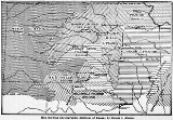
Red Hills
Encyclopedia
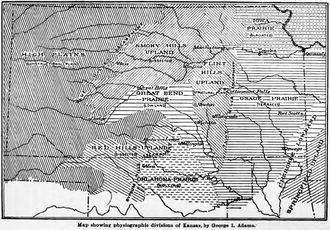
United States physiographic region
The list of continental United States Physiographic regions identifies the 8 regions, 25 provinces, and 85 sections. The system dates to Nevin Fenneman's paper Physiographic Subdivision of the United States, published in 1917...
located mostly in Clark
Clark County, Kansas
Clark County is a county located in Southwest Kansas, in the Central United States. As of the 2010 census, the county population was 2,215...
, Comanche
Comanche County, Kansas
Comanche County is a county located in Southwest Kansas, in the Central United States. As of the 2010 census, the county population was 1,891...
and Barber counties
Barber County, Kansas
Barber County is a county located in South Central Kansas, in the Central United States. As of the 2010 census, the county population was 4,861. Its county seat and most populous city is Medicine Lodge...
in southern and central Kansas
Kansas
Kansas is a US state located in the Midwestern United States. It is named after the Kansas River which flows through it, which in turn was named after the Kansa Native American tribe, which inhabited the area. The tribe's name is often said to mean "people of the wind" or "people of the south...
. This undulating terrain of red-tinted sediments, a product of the underlying geology, does not fit the conventional description of the Great Plains
Great Plains
The Great Plains are a broad expanse of flat land, much of it covered in prairie, steppe and grassland, which lies west of the Mississippi River and east of the Rocky Mountains in the United States and Canada. This area covers parts of the U.S...
landscape of Kansas.
The red bed sediment
Sediment
Sediment is naturally occurring material that is broken down by processes of weathering and erosion, and is subsequently transported by the action of fluids such as wind, water, or ice, and/or by the force of gravity acting on the particle itself....
s of the Red Hills were deposited in an arid continental closed basin that formed within the Pangaea
Pangaea
Pangaea, Pangæa, or Pangea is hypothesized as a supercontinent that existed during the Paleozoic and Mesozoic eras about 250 million years ago, before the component continents were separated into their current configuration....
n supercontinent during the Permian
Permian
The PermianThe term "Permian" was introduced into geology in 1841 by Sir Sir R. I. Murchison, president of the Geological Society of London, who identified typical strata in extensive Russian explorations undertaken with Edouard de Verneuil; Murchison asserted in 1841 that he named his "Permian...
Period. Water often flooded this basin forming ephemeral playa
Sink (geography)
A geographic sink is a depression within an endorheic basin where water collects with no visible outlet. Instead of discharging, the collected water is lost due to evaporation and/or penetration...
s of somewhat acidic waters. The shallow playas were intermittently flooded then dried leaving a mixture of lacustrine
Lake
A lake is a body of relatively still fresh or salt water of considerable size, localized in a basin, that is surrounded by land. Lakes are inland and not part of the ocean and therefore are distinct from lagoons, and are larger and deeper than ponds. Lakes can be contrasted with rivers or streams,...
sediments and gypsum
Gypsum
Gypsum is a very soft sulfate mineral composed of calcium sulfate dihydrate, with the chemical formula CaSO4·2H2O. It is found in alabaster, a decorative stone used in Ancient Egypt. It is the second softest mineral on the Mohs Hardness Scale...
evaporite
Evaporite
Evaporite is a name for a water-soluble mineral sediment that result from concentration and crystallization by evaporation from an aqueous solution. There are two types of evaporate deposits, marine which can also be described as ocean deposits, and non-marine which are found in standing bodies of...
s. The red color derives from the oxidation of iron
Iron
Iron is a chemical element with the symbol Fe and atomic number 26. It is a metal in the first transition series. It is the most common element forming the planet Earth as a whole, forming much of Earth's outer and inner core. It is the fourth most common element in the Earth's crust...
contained within the deposits.
The region is also known as the Gyp Hills, because of the large natural deposits of gypsum in this area. The dissolution of underlying gypsum beds has led to the formation of sinkhole
Sinkhole
A sinkhole, also known as a sink, shake hole, swallow hole, swallet, doline or cenote, is a natural depression or hole in the Earth's surface caused by karst processes — the chemical dissolution of carbonate rocks or suffosion processes for example in sandstone...
s which are common features within the Red Hills region. Big Basin
Big Basin Prairie Preserve
The Big Basin Prairie Preserve is a nature preserve owned and managed by the Kansas Department of Wildlife and Parks. The preserve is in the Red Hills near Ashland in Clark County, Kansas. The main features are St. Jacob's Well, a water-filled sinkhole which lies in the Little Basin, and the Big...
and Little Basin are two well-known sinkholes in western Clark County.
The Red Hills have scenic vistas and some small steep canyons. High points include Mount Nebo (2441 feet (744 m)), Mount Jesus (2340 feet (713.2 m)) and Mount Lookout (2320 feet (707.1 m)), in Clark County, Kansas
Clark County, Kansas
Clark County is a county located in Southwest Kansas, in the Central United States. As of the 2010 census, the county population was 2,215...
.
See also
- Big Basin Prairie PreserveBig Basin Prairie PreserveThe Big Basin Prairie Preserve is a nature preserve owned and managed by the Kansas Department of Wildlife and Parks. The preserve is in the Red Hills near Ashland in Clark County, Kansas. The main features are St. Jacob's Well, a water-filled sinkhole which lies in the Little Basin, and the Big...
- Tallgrass Prairie National PreserveTallgrass Prairie National PreserveTallgrass Prairie National Preserve is a United States National Preserve located in the Flint Hills region of Kansas, north of Strong City. The preserve protects a nationally significant example of the once vast tallgrass prairie ecosystem...
- Flint HillsFlint HillsThe Flint Hills, historically known as Bluestem Pastures or Blue Stem Hills, are a band of hills in eastern Kansas stretching into north-central Oklahoma, extending from Marshall County, Kansas and Washington County, Kansas in the north to Cowley County, Kansas and Osage County, Oklahoma in the south...