

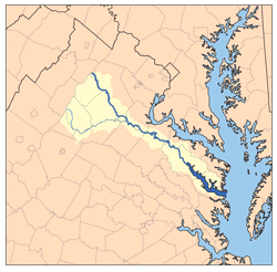
Rappahannock River
Encyclopedia
The Rappahannock River is a river in eastern Virginia
, in the United States
, approximately 195 miles (313.8 km) in length. It traverses the entire northern part of the state, from the Blue Ridge Mountains
in the west, across the Piedmont
, to the Chesapeake Bay
, south of the Potomac River
.
An important river in American history, the Rappahannock was the site of early settlements in the Virginia Colony, and, later, it was at the center of a major theatre of battle in the American Civil War
. Due to its significance as an obstacle to north-south movements, it, in effect, functioned as the war's eastern-theatre boundary, between the "North" (the Union
) and the "South" (the Confederate States of America
).
The river drains an area of 2848 square miles (7,376.3 km²), approximately 6% of Virginia. Much of the watershed is rural and forested, but it has experienced increased development in recent decades because of the southward expansion of the Washington, D.C.
suburbs.
, a wind gap in the Blue Ridge Mountains a few miles southeast of Front Royal, Virginia
, near the single point where Warren
, Fauquier
, and Rappahannock
counties come together. It flows southeastward, past Remington
, Kelly's Ford
, and Richardsville
, before it is joined by the Rapidan River
, its largest tributary
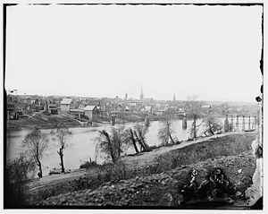
, from the right. Then the Rappahannock passes through the city of Fredericksburg
. Southeast of Fredericksburg, it begins to slow and widen into a brackish tidal estuary approximately 50 miles (80.5 km) long. It passes two small, but historic, river towns, Port Royal
and Port Conway
, which sit opposite each other, the former on the south bank, the latter on the north. Then it flows past Tappahannock
on its southern bank, a point where the river is well over a mile wide. The last settlements of any size before reaching the Chesapeake Bay are Irvington
, Stingray Point
, and White Stone Beach
.
The broad river enters Chesapeake Bay approximately 15 miles (24.1 km) south of the mouth of the Potomac and approximately 50 miles (80.5 km) east of the state capital, Richmond
. At the point where the river enters the bay, between Windmill Point, on the north, and Stingray Point
, on the south, it is more than 3.5 miles (5.6 km) wide. This area, the estuary
south of the Northern Neck
peninsula, is a productive oyster
and crab
fishery.
Above Fredericksburg, the Rappahannock provides fine opportunities for recreational canoeing
and kayaking
. Most of the rapids are Class I and Class II in difficulty, but, near Remington, there are some rapids that are considered to be Class III.
 The name of the river comes from an Algonquian
word, lappihanne (also recorded as toppehannock), meaning "river of quick, rising water" or "where the tide ebbs and flows," the name used by the local native population, the Rappahannock tribe
.
Although there had been a few small hamlets along the lower Rappahannock during early colonial times, the settlement of the Rappahannock River valley began in earnest during the first years of the eighteenth century, at the urging of Governor
Alexander Spotswood
. The James River
had been surveyed up to its fall line
, the point where, geologically, continental bedrock of the Piedmont
meets the sedimentary rock
s and alluvial soils of the coastal plain. Spotswood encouraged settlement in a river valley other than that of the James. In 1714, he began soliciting immigrants from the Rhineland-Palatinate
and Switzerland
to homestead on lands he controlled near the confluence of the Rappahannock and the Rapidan. Known as the Germanna
settlement(s), these villages were founded in order to exploit the iron ore deposits of the region.
The Battle of Rappahannock River
was fought on the river during the War of 1812
. Seventeen British boats filled with hundreds of marines and sailors captured four American privateer
s.
During the American Civil War
, the river, with few convenient fords and fewer bridges, provided a barrier and defensive line behind which movements of troops could be accomplished with little fear of attack from the river-side flank. It was an especially difficult barrier for Union
troops to overcome in their attempts to thrust into southern Virginia. Control of the river changed hands many times during the course of the war. Significant battles fought along the river include the Battle of Fredericksburg
and the Battle of Rappahannock Station. The defensive line at the river was finally circumvented by Ulysses S. Grant
in the Wilderness (or Overland) Campaign of 1864, resulting in the ultimate Union victory.
In some 18th- and 19th-century documents, including some Civil War records, the Rappahannock River was referred to as "Hedgeman's River"; a 1736-1737 survey labeled the Rappahannock above the mouth of the Rapidan as "Cannon", and further upstream it was identified as "Hedgeman's River," named after Nathaniel Hedgeman, an early settler of the region.
Virginia
The Commonwealth of Virginia , is a U.S. state on the Atlantic Coast of the Southern United States. Virginia is nicknamed the "Old Dominion" and sometimes the "Mother of Presidents" after the eight U.S. presidents born there...
, in the United States
United States
The United States of America is a federal constitutional republic comprising fifty states and a federal district...
, approximately 195 miles (313.8 km) in length. It traverses the entire northern part of the state, from the Blue Ridge Mountains
Blue Ridge Mountains
The Blue Ridge Mountains are a physiographic province of the larger Appalachian Mountains range. This province consists of northern and southern physiographic regions, which divide near the Roanoke River gap. The mountain range is located in the eastern United States, starting at its southern-most...
in the west, across the Piedmont
Piedmont (United States)
The Piedmont is a plateau region located in the eastern United States between the Atlantic Coastal Plain and the main Appalachian Mountains, stretching from New Jersey in the north to central Alabama in the south. The Piedmont province is a physiographic province of the larger Appalachian division...
, to the Chesapeake Bay
Chesapeake Bay
The Chesapeake Bay is the largest estuary in the United States. It lies off the Atlantic Ocean, surrounded by Maryland and Virginia. The Chesapeake Bay's drainage basin covers in the District of Columbia and parts of six states: New York, Pennsylvania, Delaware, Maryland, Virginia, and West...
, south of the Potomac River
Potomac River
The Potomac River flows into the Chesapeake Bay, located along the mid-Atlantic coast of the United States. The river is approximately long, with a drainage area of about 14,700 square miles...
.
An important river in American history, the Rappahannock was the site of early settlements in the Virginia Colony, and, later, it was at the center of a major theatre of battle in the American Civil War
American Civil War
The American Civil War was a civil war fought in the United States of America. In response to the election of Abraham Lincoln as President of the United States, 11 southern slave states declared their secession from the United States and formed the Confederate States of America ; the other 25...
. Due to its significance as an obstacle to north-south movements, it, in effect, functioned as the war's eastern-theatre boundary, between the "North" (the Union
Union (American Civil War)
During the American Civil War, the Union was a name used to refer to the federal government of the United States, which was supported by the twenty free states and five border slave states. It was opposed by 11 southern slave states that had declared a secession to join together to form the...
) and the "South" (the Confederate States of America
Confederate States of America
The Confederate States of America was a government set up from 1861 to 1865 by 11 Southern slave states of the United States of America that had declared their secession from the U.S...
).
The river drains an area of 2848 square miles (7,376.3 km²), approximately 6% of Virginia. Much of the watershed is rural and forested, but it has experienced increased development in recent decades because of the southward expansion of the Washington, D.C.
Washington, D.C.
Washington, D.C., formally the District of Columbia and commonly referred to as Washington, "the District", or simply D.C., is the capital of the United States. On July 16, 1790, the United States Congress approved the creation of a permanent national capital as permitted by the U.S. Constitution....
suburbs.
Description of the watercourse
The Rappahannock River rises at Chester GapChester Gap
Chester Gap, sometimes referred to as Happy Creek Gap for the creek that runs down its western slope, is a wind gap in the Blue Ridge Mountains on the border of Rappahannock County, Fauquier County and Warren County in Virginia. The gap is traversed by U.S. Route 522...
, a wind gap in the Blue Ridge Mountains a few miles southeast of Front Royal, Virginia
Front Royal, Virginia
Front Royal is a town in Warren County, Virginia, United States. The population was 13,589 at the 2000 census. It is the county seat of Warren County.-Geography:Front Royal is roughly west of Washington, D.C....
, near the single point where Warren
Warren County, Virginia
As of the census of 2000, there were 31,584 people, 12,087 households, and 8,521 families residing in the county. The population density was 148 people per square mile . There were 13,299 housing units at an average density of 62 per square mile...
, Fauquier
Fauquier County, Virginia
As of the census of 2000, there were 55,139 people, 19,842 households, and 15,139 families residing in the county. The population density was 85 people per square mile . There were 21,046 housing units at an average density of 32 per square mile...
, and Rappahannock
Rappahannock County, Virginia
As of the census of 2010, there were 7,373 people, 2,788 households, and 2,004 families residing in the county. The population density was 26 people per square mile . There were 3,303 housing units at an average density of 12 per square mile...
counties come together. It flows southeastward, past Remington
Remington, Virginia
Remington is a small incorporated town in Fauquier County, Virginia, United States. The population was 624 at the 2000 census, and at the 2008 census, the population is 673. It is near the highways, U.S. Route 15, U.S. Route 17, U.S. Route 29, and Virginia State Route 28...
, Kelly's Ford
Kellys Ford, Virginia
Kelly's Ford was a major crossing point on the Rappahannock River. It was the site of a Civil War battle for control of the river ford. Today it is the only crossing on the river between Fredericksburg and Remington. It is the location of the Inn at Kelly's Ford and the Kelly's Ford Equestrian Center...
, and Richardsville
Richardsville, Virginia
Richardsville is a small unincorporated community in Culpeper County, Virginia, United States. Its location is isolated between the Rapidan and Rappahannock rivers. It was the site of many of Virginia's gold mines in the early 19th century and the site of many troop movements and skirmishes during...
, before it is joined by the Rapidan River
Rapidan River
The Rapidan River, flowing through north-central Virginia in the United States, is the largest tributary of the Rappahannock River. The two rivers converge just west of the city of Fredericksburg...
, its largest tributary
Tributary
A tributary or affluent is a stream or river that flows into a main stem river or a lake. A tributary does not flow directly into a sea or ocean...
, from the right. Then the Rappahannock passes through the city of Fredericksburg
Fredericksburg, Virginia
Fredericksburg is an independent city in the Commonwealth of Virginia located south of Washington, D.C., and north of Richmond. As of the 2010 census, the city had a population of 24,286...
. Southeast of Fredericksburg, it begins to slow and widen into a brackish tidal estuary approximately 50 miles (80.5 km) long. It passes two small, but historic, river towns, Port Royal
Port Royal, Virginia
Port Royal is an incorporated town in Caroline County, Virginia, United States. The population was 170 at the 2000 census.Port Royal was established in the mid-17th century in the Colony of Virginia primary as a port on a navigable portion of the Rappahannock River for export of tobacco, Virginia's...
and Port Conway
Port Conway, Virginia
Port Conway is an unincorporated community on the north side of the Rappahannock River in King George County, in the Northern Neck of Virginia, in the United States...
, which sit opposite each other, the former on the south bank, the latter on the north. Then it flows past Tappahannock
Tappahannock, Virginia
Tappahannock is the oldest town in Essex County, Virginia, United States. The population was 2,068 at the 2000 census. Located on the Rappahannock River, Tappahannock is the county seat of Essex County...
on its southern bank, a point where the river is well over a mile wide. The last settlements of any size before reaching the Chesapeake Bay are Irvington
Irvington, Virginia
Irvington is a town in Lancaster County, Virginia, United States. The population was 673 at the 2000 census and it is located on a peninsula of land known as the Northern Neck. It is the name also of a historic district....
, Stingray Point
Stingray Point
Stingray Point is a small community on the Chesapeake Bay near the village of Deltaville in Middlesex County, Virginia. It is located at the eastern terminus of State Route 33. It is populated by fewer than 250 full time residents; however, during summer months that population surges as tourists...
, and White Stone Beach
White Stone, Virginia
White Stone is a town in Lancaster County, Virginia, United States. The population was 358 at the 2000 census. The name "White Stone" refers to the accumulations of white stones in the area's waterways...
.
The broad river enters Chesapeake Bay approximately 15 miles (24.1 km) south of the mouth of the Potomac and approximately 50 miles (80.5 km) east of the state capital, Richmond
Richmond, Virginia
Richmond is the capital of the Commonwealth of Virginia, in the United States. It is an independent city and not part of any county. Richmond is the center of the Richmond Metropolitan Statistical Area and the Greater Richmond area...
. At the point where the river enters the bay, between Windmill Point, on the north, and Stingray Point
Stingray Point
Stingray Point is a small community on the Chesapeake Bay near the village of Deltaville in Middlesex County, Virginia. It is located at the eastern terminus of State Route 33. It is populated by fewer than 250 full time residents; however, during summer months that population surges as tourists...
, on the south, it is more than 3.5 miles (5.6 km) wide. This area, the estuary
Estuary
An estuary is a partly enclosed coastal body of water with one or more rivers or streams flowing into it, and with a free connection to the open sea....
south of the Northern Neck
Northern Neck
The Northern Neck is the northernmost of three peninsulas on the western shore of the Chesapeake Bay in the Commonwealth of Virginia. This peninsula is bounded by the Potomac River on the north and the Rappahannock River on the south. It encompasses the following Virginia counties: Lancaster,...
peninsula, is a productive oyster
Oyster
The word oyster is used as a common name for a number of distinct groups of bivalve molluscs which live in marine or brackish habitats. The valves are highly calcified....
and crab
Crab
True crabs are decapod crustaceans of the infraorder Brachyura, which typically have a very short projecting "tail" , or where the reduced abdomen is entirely hidden under the thorax...
fishery.
Above Fredericksburg, the Rappahannock provides fine opportunities for recreational canoeing
Canoeing
Canoeing is an outdoor activity that involves a special kind of canoe.Open canoes may be 'poled' , sailed, 'lined and tracked' or even 'gunnel-bobbed'....
and kayaking
Kayaking
Kayaking is the use of a kayak for moving across water. Kayaking and canoeing are also known as paddling. Kayaking is distinguished from canoeing by the sitting position of the paddler and the number of blades on the paddle...
. Most of the rapids are Class I and Class II in difficulty, but, near Remington, there are some rapids that are considered to be Class III.
History
Algonquian languages
The Algonquian languages also Algonkian) are a subfamily of Native American languages which includes most of the languages in the Algic language family. The name of the Algonquian language family is distinguished from the orthographically similar Algonquin dialect of the Ojibwe language, which is a...
word, lappihanne (also recorded as toppehannock), meaning "river of quick, rising water" or "where the tide ebbs and flows," the name used by the local native population, the Rappahannock tribe
Rappahannock Tribe
The Rappahannock are one of the eleven state-recognized Native American tribes in Virginia. They are made up of descendants of several small Algonquian-speaking tribes who merged in the 17th century.-17th century:...
.
Although there had been a few small hamlets along the lower Rappahannock during early colonial times, the settlement of the Rappahannock River valley began in earnest during the first years of the eighteenth century, at the urging of Governor
Governor
A governor is a governing official, usually the executive of a non-sovereign level of government, ranking under the head of state...
Alexander Spotswood
Alexander Spotswood
Alexander Spotswood was a Lieutenant-Colonel in the British Army and a noted Lieutenant Governor of Virginia. He is noted in Virginia and American history for a number of his projects as Governor, including his exploring beyond the Blue Ridge Mountains, his establishing what was perhaps the first...
. The James River
James River
The James River may refer to:Rivers in the United States and their namesakes* James River * James River , North Dakota, South Dakota* James River * James River * James River...
had been surveyed up to its fall line
Fall line
A fall line is a geomorphologic unconformity between an upland region of relatively hard crystalline basement rock and a coastal plain of softer sedimentary rock. A fall line is typically prominent when crossed by a river, for there will often be rapids or waterfalls...
, the point where, geologically, continental bedrock of the Piedmont
Piedmont (United States)
The Piedmont is a plateau region located in the eastern United States between the Atlantic Coastal Plain and the main Appalachian Mountains, stretching from New Jersey in the north to central Alabama in the south. The Piedmont province is a physiographic province of the larger Appalachian division...
meets the sedimentary rock
Sedimentary rock
Sedimentary rock are types of rock that are formed by the deposition of material at the Earth's surface and within bodies of water. Sedimentation is the collective name for processes that cause mineral and/or organic particles to settle and accumulate or minerals to precipitate from a solution....
s and alluvial soils of the coastal plain. Spotswood encouraged settlement in a river valley other than that of the James. In 1714, he began soliciting immigrants from the Rhineland-Palatinate
Rhineland-Palatinate
Rhineland-Palatinate is one of the 16 states of the Federal Republic of Germany. It has an area of and about four million inhabitants. The capital is Mainz. English speakers also commonly refer to the state by its German name, Rheinland-Pfalz ....
and Switzerland
Switzerland
Switzerland name of one of the Swiss cantons. ; ; ; or ), in its full name the Swiss Confederation , is a federal republic consisting of 26 cantons, with Bern as the seat of the federal authorities. The country is situated in Western Europe,Or Central Europe depending on the definition....
to homestead on lands he controlled near the confluence of the Rappahannock and the Rapidan. Known as the Germanna
Germanna
Germanna was a German settlement in the Colony of Virginia, settled in two waves, first in 1714 and then in 1717. Virginia Lieutenant Governor Alexander Spotswood encouraged the immigration by advertising in Germany for miners to move to Virginia and establish a mining industry in the...
settlement(s), these villages were founded in order to exploit the iron ore deposits of the region.
The Battle of Rappahannock River
Battle of Rappahannock River
The Battle of Rappahannock River was fought in 1813 during the War of 1812. A British force blockading the Rappahannock River of Virginia sent several hundred men in boats to attack four American privateers...
was fought on the river during the War of 1812
War of 1812
The War of 1812 was a military conflict fought between the forces of the United States of America and those of the British Empire. The Americans declared war in 1812 for several reasons, including trade restrictions because of Britain's ongoing war with France, impressment of American merchant...
. Seventeen British boats filled with hundreds of marines and sailors captured four American privateer
Privateer
A privateer is a private person or ship authorized by a government by letters of marque to attack foreign shipping during wartime. Privateering was a way of mobilizing armed ships and sailors without having to spend public money or commit naval officers...
s.
During the American Civil War
American Civil War
The American Civil War was a civil war fought in the United States of America. In response to the election of Abraham Lincoln as President of the United States, 11 southern slave states declared their secession from the United States and formed the Confederate States of America ; the other 25...
, the river, with few convenient fords and fewer bridges, provided a barrier and defensive line behind which movements of troops could be accomplished with little fear of attack from the river-side flank. It was an especially difficult barrier for Union
Union (American Civil War)
During the American Civil War, the Union was a name used to refer to the federal government of the United States, which was supported by the twenty free states and five border slave states. It was opposed by 11 southern slave states that had declared a secession to join together to form the...
troops to overcome in their attempts to thrust into southern Virginia. Control of the river changed hands many times during the course of the war. Significant battles fought along the river include the Battle of Fredericksburg
Battle of Fredericksburg
The Battle of Fredericksburg was fought December 11–15, 1862, in and around Fredericksburg, Virginia, between General Robert E. Lee's Confederate Army of Northern Virginia and the Union Army of the Potomac, commanded by Maj. Gen. Ambrose E. Burnside...
and the Battle of Rappahannock Station. The defensive line at the river was finally circumvented by Ulysses S. Grant
Ulysses S. Grant
Ulysses S. Grant was the 18th President of the United States as well as military commander during the Civil War and post-war Reconstruction periods. Under Grant's command, the Union Army defeated the Confederate military and ended the Confederate States of America...
in the Wilderness (or Overland) Campaign of 1864, resulting in the ultimate Union victory.
In some 18th- and 19th-century documents, including some Civil War records, the Rappahannock River was referred to as "Hedgeman's River"; a 1736-1737 survey labeled the Rappahannock above the mouth of the Rapidan as "Cannon", and further upstream it was identified as "Hedgeman's River," named after Nathaniel Hedgeman, an early settler of the region.
See also
- Ferry FarmFerry FarmFerry Farm, also known as George Washington Boyhood Home Site or Ferry Farm Site, is the name of the farm and home at which George Washington spent much of his childhood. The site is located in Stafford County, Virginia, along the northern bank of the Rappahannock River, across from the city of...
- Knights of the Golden Horseshoe ExpeditionKnights of the Golden Horseshoe ExpeditionThe Knights of the Golden Horseshoe Expedition took place in 1716 in the British Colony of Virginia. The Royal Governor and a number of prominent citizens traveled westward, across the Blue Ridge Mountains on an exploratory expedition...
- List of Virginia rivers
- Stingray Point LightStingray Point LightThe Stingray Point Light was a lighthouse located at the mouth of the Rappahannock River.-History:Stingray Point took its name from an incident in which John Smith was stung by a stingray while fishing nearby. The light was built in 1858 to mark the entrance to the Deltaville harbor, just west of...
- Windmill Point LightWindmill Point Light (Virginia)The Windmill Point Light was a lighthouse located at the mouth of the Rappahannock River.-History:This light was erected in 1869 to replace the last of three lightships stationed at this location to mark the end of the Rappahannock Spit, a shoal extending east from Windmill Point itself...