

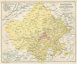
Rajputana
Encyclopedia
India
India , officially the Republic of India , is a country in South Asia. It is the seventh-largest country by geographical area, the second-most populous country with over 1.2 billion people, and the most populous democracy in the world...
n state of Rājasthān
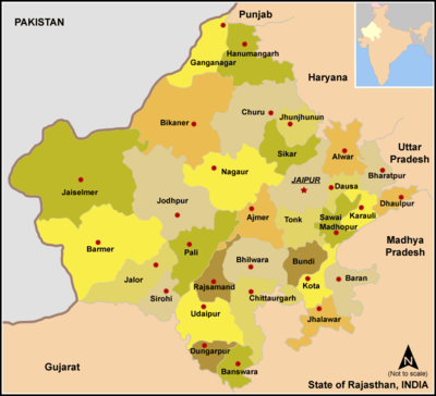
Rajasthan
Rājasthān the land of Rajasthanis, , is the largest state of the Republic of India by area. It is located in the northwest of India. It encompasses most of the area of the large, inhospitable Great Indian Desert , which has an edge paralleling the Sutlej-Indus river valley along its border with...
, the largest state of the Republic of India in terms of area. George Thomas (Military Memories) was the first in 1800 A.D., to term this region as Rajputana. During British period, this area had about 14 main Rajput
Rajput
A Rajput is a member of one of the patrilineal clans of western, central, northern India and in some parts of Pakistan. Rajputs are descendants of one of the major ruling warrior classes in the Indian subcontinent, particularly North India...
Princely states
Princely state
A Princely State was a nominally sovereign entitity of British rule in India that was not directly governed by the British, but rather by an Indian ruler under a form of indirect rule such as suzerainty or paramountcy.-British relationship with the Princely States:India under the British Raj ...
.
The historian John Keay
John Keay
John Keay is an English journalist and author specialising in writing popular histories about India and the Far East, often with a particular focus on their colonisation and exploration by Europeans.-Life and career:...
in his book, India: A History stated that the Rajputana name was coined by the British
British Raj
British Raj was the British rule in the Indian subcontinent between 1858 and 1947; The term can also refer to the period of dominion...
, but that the word even achieved a retrospective authenticity: in an 1829 translation of Ferishta's history of early Islamic India, John Briggs discarded the phrase Indian princes, as rendered in Dow's earlier version, and substituted Rajpoot princes. It was essentially the country of the Gurjars. Historian R. C. Majumdar
R. C. Majumdar
Ramesh Chandra Majumdar was an Indian historian of great repute. He is sometimes called "the dean of Indian historians" for his colossal contribution to the study of Indian history.-Early life and education:...
explained that the region was long known as Gurjaratra (Country protected by the Gurjars or Gurjar nation), early form of Gujarat, before it came to be called Rajputana, early in the Muslim period.
Geography
The area of Rajputana is estimated to be 132,559 square miles (343,328 square km) and breaks down into two geographic divisions:- An area northwest of the Arāvalli Range including part of the Great Indian (Thar) Desert, with characteristics of being sandy and unproductive.
- A higher area southeast of the range, which is fertile by comparison.
The whole area forms the hill and plateau country between the north Indian plains and the main plateau of peninsular India.