
Raise
Encyclopedia
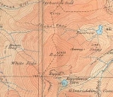
Raise is a fell
in the English
Lake District
. It stands on the main spine of the Helvellyn range
in the Eastern Fells
, between Thirlmere
and Ullswater
.
to the north and White Side
to the south. As with many of these fells, Raise displays smooth grassy slopes on the west and rougher ground to the east. Here however the contrast is much less marked than further south around Helvellyn
and Nethermost Pike
.
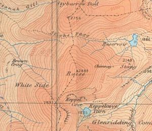 Unusually for such a high fell, the slopes of Raise do not have a toehold at valley level on either side. In the west the boundary streams of Sticks Gill (West) and Brund Gill meet just below White Side's Brown Crag. As Fisherplace Gill they descend a further thousand feet to the valley, and originally turned north to join St John's Beck. All of this changed as part of the Thirlmere reservoir scheme in 1894, when a water race was constructed to carry most of the water into the lake. To the east the fell is also squeezed out at height by its neighbours, failing to reach the shore of Ullswater. Raise has a short eastern ridge, Stang, descending between Sticks Gill (East) and Glenridding Beck, but these streams combine above the site of the old Greenside Mine to leave Sheffield Pike
and Birkhouse Moor
overlooking Glenridding.
To the north of Raise the pedestrian route of Sticks Pass crosses the ridge at a height of 2,445 ft (745 m), this being the highest pass in the District crossed by a regular bridleway. Now of use purely to hillwalkers, it once provided the only connection between the communities on either side of the Helvellyns. The name is believed to be taken from the guideposts originally used to mark the route.. The becks flowing from either side of the pass summit are both officially named Sticks Gill, the '(East)' and '(West)' having been added by Alfred Wainwright
in his Pictorial Guide to the Lakeland Fells
and utilised by later guidebook writers. To the north, beyond the pass, the ground rises again to Stybarrow Dodd and all here is grass.
whose back wall is named Red Screes. Kepple Cove once contained an artificial tarn
, although today the bed is merely marshy except after heavy rain. The water from the tarn was used in a hydroelectric scheme to drive electric winding gear at Greenside Mine. Commissioned in 1891, this was the first such system in the country.. It continued in use until the night of 29 October 1927 when the Kepple Cove dam burst during a heavy storm, leaving an 80 ft (24.4 m) wide gap in the earthworks. The resulting wave passed down the valley and through Glenridding village, flooding buildings and causing extensive damage. The breached dam can still be seen today.
A further tarn serving Greenside Mine was created in Sticks Gill (East) by the construction of a stone barrage. Called Top Dam, this was still in existence in the 1950s but is now a dry bed. There are other signs of mining activity on the Stang ridge, in particular the stone smelter flue. Prominently marked 'chimney' on Ordnance Survey
maps, the flue ran over half a mile up the fellside to a stone chimney at about 2250 ft (685.8 m). There are also the remains of a number of leats, artificial channels to divert streams to the thirsty mine. Stang now carries the marks of a more modern industry, with the Lake District's only permanent ski-tow installed on the northern slope. There is some rock outcropping on the eastern slopes of Raise, particularly at Stang End above the Glenridding Beck.
s to the south. The view is extensive with all of the major fells being seen. Thirlmere can also be brought into view by walking a few yards to the west.
Fell
“Fell” is a word used to refer to mountains, or certain types of mountainous landscape, in Scandinavia, the Isle of Man, and parts of northern England.- Etymology :...
in the English
England
England is a country that is part of the United Kingdom. It shares land borders with Scotland to the north and Wales to the west; the Irish Sea is to the north west, the Celtic Sea to the south west, with the North Sea to the east and the English Channel to the south separating it from continental...
Lake District
Lake District
The Lake District, also commonly known as The Lakes or Lakeland, is a mountainous region in North West England. A popular holiday destination, it is famous not only for its lakes and its mountains but also for its associations with the early 19th century poetry and writings of William Wordsworth...
. It stands on the main spine of the Helvellyn range
Helvellyn range
Helvellyn range is the name given to a part of the Eastern Fells in the English Lake District, fell being the local word for hill. The name comes from Helvellyn, the highest point of the group....
in the Eastern Fells
Eastern Fells
The Eastern Fells are a group of hills in the English Lake District. Centred on Helvellyn they primarily comprise a north south ridge running between Ullswater and Lakeland's Central Valley.-Partition of the Lakeland Fells:...
, between Thirlmere
Thirlmere
Thirlmere is a reservoir in the Borough of Allerdale in Cumbria and the English Lake District. It runs roughly south to north, with a dam at the northern end, and is bordered on the eastern side by the A591 road and on the western side by a minor road....
and Ullswater
Ullswater
Ullswater is the second largest lake in the English Lake District, being approximately nine miles long and 0.75 miles wide with a maximum depth of slightly more than ....
.
Topography
The Helvellyn range runs broadly north-south for about 7 miles (11.3 km), remaining above 2,000 ft (600 m) throughout its length. Raise is near the centre of this ridge, with Stybarrow DoddStybarrow Dodd
Stybarrow Dodd is a fell in the English Lake District. It stands on the main spine of the Helvellyn range in the Eastern Fells, situated between Thirlmere and the Ullswater catchment.-Topography:...
to the north and White Side
White Side
White Side is a fell in the English Lake District. It is situated to the east of Thirlmere and to the west of Glenridding valley. This places White Side in the Helvellyn range of the Eastern Fells, with Raise to the north and Helvellyn Lower Man to the south, both of which are of greater...
to the south. As with many of these fells, Raise displays smooth grassy slopes on the west and rougher ground to the east. Here however the contrast is much less marked than further south around Helvellyn
Helvellyn
Helvellyn is a mountain in the English Lake District, the apex of the Eastern Fells. At above sea level, it is the third highest peak in both the Lake District and England...
and Nethermost Pike
Nethermost Pike
Nethermost Pike is a fell in Cumbria, England, and a part of the Lake District. At it is the second highest Wainwright in the Helvellyn range, the tallest of which is Helvellyn itself. It is located close to the southern end of the ridge, with Helvellyn to the north, and High Crag and Dollywaggon...
.
Sheffield Pike
Sheffield Pike is a fell in the English Lake District, an outlier of the Helvellyn range in the Eastern Fells. It stands on the eastern side of the range, looking down on Ullswater.-Topography:...
and Birkhouse Moor
Birkhouse Moor
Birkhouse Moor is a fell in the English Lake District, an outlier of the Helvellyn range in the Eastern Fells. It is properly an eastern ridge of Helvellyn, but was treated as a separate fell by Alfred Wainwright in his Pictorial Guide to the Lakeland Fells...
overlooking Glenridding.
To the north of Raise the pedestrian route of Sticks Pass crosses the ridge at a height of 2,445 ft (745 m), this being the highest pass in the District crossed by a regular bridleway. Now of use purely to hillwalkers, it once provided the only connection between the communities on either side of the Helvellyns. The name is believed to be taken from the guideposts originally used to mark the route.. The becks flowing from either side of the pass summit are both officially named Sticks Gill, the '(East)' and '(West)' having been added by Alfred Wainwright
Alfred Wainwright
Alfred Wainwright MBE was a British fellwalker, guidebook author and illustrator. His seven-volume Pictorial Guide to the Lakeland Fells, published between 1955 and 1966 and consisting entirely of reproductions of his manuscript, has become the standard reference work to 214 of the fells of the...
in his Pictorial Guide to the Lakeland Fells
Pictorial Guide to the Lakeland Fells
A Pictorial Guide to the Lakeland Fells is a series of seven books by A. Wainwright, detailing the fells of the Lake District in northwest England...
and utilised by later guidebook writers. To the north, beyond the pass, the ground rises again to Stybarrow Dodd and all here is grass.
Mining History
South of Raise the ridge swings a little to the west, crossing an unnamed col on the way to White Side. The eastern face of this ridge is gouged deeply by Kepple Cove, a corrieCirque
Cirque may refer to:* Cirque, a geological formation* Makhtesh, an erosional landform found in the Negev desert of Israel and Sinai of Egypt*Cirque , an album by Biosphere* Cirque Corporation, a company that makes touchpads...
whose back wall is named Red Screes. Kepple Cove once contained an artificial tarn
Tarn (lake)
A tarn is a mountain lake or pool, formed in a cirque excavated by a glacier. A moraine may form a natural dam below a tarn. A corrie may be called a cirque.The word is derived from the Old Norse word tjörn meaning pond...
, although today the bed is merely marshy except after heavy rain. The water from the tarn was used in a hydroelectric scheme to drive electric winding gear at Greenside Mine. Commissioned in 1891, this was the first such system in the country.. It continued in use until the night of 29 October 1927 when the Kepple Cove dam burst during a heavy storm, leaving an 80 ft (24.4 m) wide gap in the earthworks. The resulting wave passed down the valley and through Glenridding village, flooding buildings and causing extensive damage. The breached dam can still be seen today.
A further tarn serving Greenside Mine was created in Sticks Gill (East) by the construction of a stone barrage. Called Top Dam, this was still in existence in the 1950s but is now a dry bed. There are other signs of mining activity on the Stang ridge, in particular the stone smelter flue. Prominently marked 'chimney' on Ordnance Survey
Ordnance Survey
Ordnance Survey , an executive agency and non-ministerial government department of the Government of the United Kingdom, is the national mapping agency for Great Britain, producing maps of Great Britain , and one of the world's largest producers of maps.The name reflects its creation together with...
maps, the flue ran over half a mile up the fellside to a stone chimney at about 2250 ft (685.8 m). There are also the remains of a number of leats, artificial channels to divert streams to the thirsty mine. Stang now carries the marks of a more modern industry, with the Lake District's only permanent ski-tow installed on the northern slope. There is some rock outcropping on the eastern slopes of Raise, particularly at Stang End above the Glenridding Beck.
Geology
Geologically, the summit of Raise is part of the Birker Fell Formation of plagioclase-phyric andesite lava, with pyroclastic breccia to the south west. There are also substantial areas of gravel drift.Summit and View
Alone among the northern Helvellyns, Raise has a summit area of outcropping rock, an island amid the sea of grass. A little to the east of the top is a rock tor which would be insignificant elsewhere, but in these surroundings draws the eye. A path follows the ridge, with a surfeit of cairnCairn
Cairn is a term used mainly in the English-speaking world for a man-made pile of stones. It comes from the or . Cairns are found all over the world in uplands, on moorland, on mountaintops, near waterways and on sea cliffs, and also in barren desert and tundra areas...
s to the south. The view is extensive with all of the major fells being seen. Thirlmere can also be brought into view by walking a few yards to the west.