

Raedykes
Encyclopedia

Roman Empire
The Roman Empire was the post-Republican period of the ancient Roman civilization, characterised by an autocratic form of government and large territorial holdings in Europe and around the Mediterranean....
marching camp located just over 3 miles (5 ) NW of Stonehaven
Stonehaven
Stonehaven is a town in Aberdeenshire, Scotland. It lies on Scotland's northeast coast and had a population of 9,577 in 2001 census.Stonehaven, county town of Kincardineshire, grew around an Iron Age fishing village, now the "Auld Toon" , and expanded inland from the seaside...
, Aberdeenshire
Aberdeenshire
Aberdeenshire is one of the 32 unitary council areas in Scotland and a lieutenancy area.The present day Aberdeenshire council area does not include the City of Aberdeen, now a separate council area, from which its name derives. Together, the modern council area and the city formed historic...
, Scotland
Scotland
Scotland is a country that is part of the United Kingdom. Occupying the northern third of the island of Great Britain, it shares a border with England to the south and is bounded by the North Sea to the east, the Atlantic Ocean to the north and west, and the North Channel and Irish Sea to the...
. National Grid Reference NO 842902. A marching camp was a temporary camp used mainly for overnight stops on a long route between more permanent forts, or as a temporary base while on campaign in hostile territory.
The site
Raedykes probably dates from the late 1st century AD (AgricolanGnaeus Julius Agricola
Gnaeus Julius Agricola was a Roman general responsible for much of the Roman conquest of Britain. His biography, the De vita et moribus Iulii Agricolae, was the first published work of his son-in-law, the historian Tacitus, and is the source for most of what is known about him.Born to a noted...
), though it has been argued that it could be Antonine
Antoninus Pius
Antoninus Pius , also known as Antoninus, was Roman Emperor from 138 to 161. He was a member of the Nerva-Antonine dynasty and the Aurelii. He did not possess the sobriquet "Pius" until after his accession to the throne...
(2nd century) or Severan (early 3rd century).
The camp rampart (vallum
Vallum
Vallum is a term applied either to the whole or a portion of the fortifications of a Roman camp. The vallum usually comprised an earthen or turf rampart with a wooden palisade on top, with a deep outer ditch...
) encloses the summit and eastern slopes of Garrison Hill (191m 628 ft), a prominent spur overlooking the valley of the Cowie Water, a small river draining into the North Sea
North Sea
In the southwest, beyond the Straits of Dover, the North Sea becomes the English Channel connecting to the Atlantic Ocean. In the east, it connects to the Baltic Sea via the Skagerrak and Kattegat, narrow straits that separate Denmark from Norway and Sweden respectively...
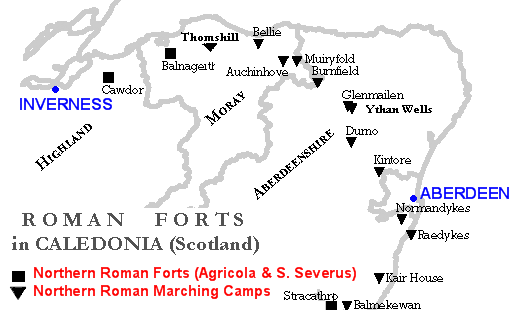
on the outskirts of Stonehaven. The camp covered an area of about 93 acres (37 ha), and a computer model suggests that this would have been sufficient to house three full legions, or around 16,000 troops
The entire perimeter of Raedykes camp has been recorded, and is very irregular in shape, because of the terrain. There were six gateways of which five are visible, all protected by titulus outworks; two in the longest E side, one in the shortest S side, another in the N side and one more in the very-irregular SW side. The Mid Raedykes Farm lies inside the NW corner of the camp and Broomhill Farm lies just inside the E rampart beside the southern-most E gateway.
Raedykes is situated a day's march north from Stracathro
Stracathro
Stracathro is a small place in Angus, Scotland,-Location:Stracathro is located 2½ miles southeast of Edzell in NE Angus. It lies to the northeast of Brechin on the A90.-History:...
fort (initially also a marching camp) and rather less than a day's march south of Normandykes
Normandykes
Normandykes is the site of a Roman marching camp to the southwest of Peterculter, Aberdeenshire, Scotland. The near-rectangular site, measuring approximately , covers about of the summit and eastern slopes of a hill overlooking the River Dee and the B9077 road further south. Aerial photographs...
.
History
The Roman army established a chain of forts and camps during the late 1st century AD at ArdochArdoch
Ardoch Roman Fort is an archaeological site just outside the village of Braco in Perthshire, Scotland, about 7 miles south of Crieff. At Ardoch are the remains of a Roman fort and castra which included Ardoch Tower...
, Strageath
Strageath
Strageath is a Roman camp near the River Earn in eastern Scotland. Strageath was one of a chain of camps that the Romans used in their march northward. Other notable camps in this chain are Ardoch, Battledykes, Stracathro, Raedykes and Normandykes....
, Inchtuthil
Inchtuthil
Inchtuthil is the site of a Roman legionary fortress situated on a natural platform overlooking the north bank of the River Tay southwest of Blairgowrie, Perth and Kinross, Scotland.It was built in 82 or 83 AD as the advance headquarters for the forces of governor Gnaeus Julius...
, Battledykes
Battledykes
Battledykes is a Roman Camp established slightly to the north of Forfar, Scotland. According to Hector Boece, Pictish chiefs met at a castle by Forfar Loch to plan how to repel the Roman armies, who invaded several times between the 1st and 4th centuries AD. Eventually the better equipped Romans...
, Stracathro, Raedykes (probably), Normandykes, Glenmailen, Bellie, Balnageith and Cawdor
Cawdor (Roman Fort)
Cawdor , located near the small village of Eastern Galcantray , is suspected of being one of the northernmost Roman forts in Great Britain, though this evidence is controversial.-History:...
. Many of these forts and camps were reoccupied during the reign of emperor Septimius Severus
Septimius Severus
Septimius Severus , also known as Severus, was Roman Emperor from 193 to 211. Severus was born in Leptis Magna in the province of Africa. As a young man he advanced through the customary succession of offices under the reigns of Marcus Aurelius and Commodus. Severus seized power after the death of...
about a century later.
In the summer of 84 Agricola defeated the massed armies of the Caledonians, possibly led by Calgacus
Calgacus
According to Tacitus, Calgacus was a chieftain of the Caledonian Confederacy who fought the Roman army of Gnaeus Julius Agricola at the Battle of Mons Graupius in northern Scotland in AD 83 or 84...
, at the battle of Mons Graupius
Battle of Mons Graupius
According to Tacitus, the Battle of Mons Graupius took place in AD 83 or, less probably, 84. Gnaeus Julius Agricola, the Roman governor and Tacitus' father-in-law, had sent his fleet ahead to panic the Caledonians, and, with light infantry reinforced with British auxiliaries, reached the site,...
. The area around Raedykes including nearby Kempstone Hill
Kempstone Hill
Kempstone Hill is a landform in Aberdeenshire, Scotland within the Mounth Range of the Grampian Mountains. The peak elevation of this mountain is 132 metres above mean sea level. This hill has been posited by Gabriel Jacques Surenne, Archibald Watt and C.Michael Hogan as the location for the...
has been advanced by Gabriel Jacques Surenne
Gabriel Jacques Surenne
Gabriel Jacques Surenne was a 19th-century French military historian who authored numerous publications in the fields of warfare and battle analysis and also in French grammar...
and other scholars as the likely location for the battle in AD 83 or 84. The prominent hill called Bennachie, much further north, overlooking Inverurie
Inverurie
Inverurie is a Royal Burgh and town in Aberdeenshire, Scotland, approximately north west of Aberdeen on the A96 road and is served by Inverurie railway station on the Aberdeen to Inverness Line...
near the Roman camp at Durno, is another potential site. However, there is no general agreement about the site of the battle, and no direct evidence to pinpoint it.
See also
- Fetteresso CastleFetteresso CastleFetteresso Castle is a 14th century towerhouse, rebuilt in 1761 as a Scottish gothic style Palladian manor, with clear evidence of prehistoric use of the site. It is situated immediately west of the town of Stonehaven in Kincardineshire slightly to the west of the A90 dual carriageway...
14th century towerhouse, 3m (5 km) south - Muchalls CastleMuchalls CastleMuchalls Castle stands overlooking the North Sea in the countryside of Kincardine and Mearns, Aberdeenshire, Scotland. The lower course is a well preserved double groined 13th century towerhouse structure, built by the Frasers of Muchalls. Upon this structure, the 17th century castle was begun by...
13th century towerhouse, 3m (5 km) east - Burn of MuchallsBurn of MuchallsThe Burn of Muchalls is an easterly flowing stream in Aberdeenshire, Scotland that discharges to the North Sea. Its point of discharge is on a rocky beach set with scenic sea stacks...
- NormandykesNormandykesNormandykes is the site of a Roman marching camp to the southwest of Peterculter, Aberdeenshire, Scotland. The near-rectangular site, measuring approximately , covers about of the summit and eastern slopes of a hill overlooking the River Dee and the B9077 road further south. Aerial photographs...
Roman marching camp, 6m (9 km) north - Cawdor (Roman Fort)Cawdor (Roman Fort)Cawdor , located near the small village of Eastern Galcantray , is suspected of being one of the northernmost Roman forts in Great Britain, though this evidence is controversial.-History:...
near InvernessInvernessInverness is a city in the Scottish Highlands. It is the administrative centre for the Highland council area, and is regarded as the capital of the Highlands of Scotland... - InchtuthilInchtuthilInchtuthil is the site of a Roman legionary fortress situated on a natural platform overlooking the north bank of the River Tay southwest of Blairgowrie, Perth and Kinross, Scotland.It was built in 82 or 83 AD as the advance headquarters for the forces of governor Gnaeus Julius...
site of a Roman legionary fortress, near BlairgowrieBlairgowrieBlairgowrie is the name of several places in the world:* Blairgowrie and Rattray, United Kingdom* Blairgowrie, Victoria, Australia* Blairgowrie, Gauteng, South Africa...