
Radnorshire
Encyclopedia
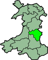
Radnorshire is one of thirteen historic and former administrative counties of Wales
. It is represented by the Radnorshire area of Powys
, which according to the 2001 census, had a population of 24,805. The historic county is bounded to the north by Montgomeryshire
and Shropshire
, to the east by Herefordshire
, to the south by Brecknockshire
and to the west by Cardiganshire
.
The county was formed from the cantrefs of Maelienydd
and Elfael
and the commote
s of Gwrtheyrnion
and Deuddwr (the area formerly known as Rhwng Gwy a Hafren
) by the Laws in Wales Acts 1535-1542
. New Radnor
was considered the county town
, although it historically shared administrative functions with Presteigne
where the Assizes
sat. Radnor County Council and later the District Council were based instead at Llandrindod Wells
.
The county was abolished by the Local Government Act 1972
in 1974, with its area being transferred to the new county of Powys
. Powys was divided into three districts, one of which (Radnor) was coterminous with Radnorshire. The district was renamed Radnorshire in 1989. Since Powys became a unitary authority in 1996, Radnorshire has been one of three areas formed under a decentralisation
scheme. A "shire committee" consisting of councillors elected for electoral divisions within the former district of Radnorshire exercises functions delegated by Powys County Council.
running through the west of the county. The highest point is at Radnor Forest
, 2,166 ft (660 m). The Elan Valley
contains several huge man-made reservoirs supplying water to Birmingham
. The main rivers are the Wye
, The River Teme
, the Elan and the Ithon
.
The chief towns are Knighton, Llandrindod Wells
, Presteigne
and Rhayader
. The main industries are tourism and hill farming, particularly sheep-raising.
. The names of the hundreds, which were not always consistently spelt, were as follows:
grouped parishes into poor law union
s. While these were not themselves local authorities, their boundaries were to later be used to define local government districts. PLUs did not conform to county boundaries, but consisted of catchment areas for workhouse
s. Most of Radnorshire was included in the three unions of Knighton, Presteigne and Rhayader. Parishes on the edges of the county were included in unions based in other counties: Builth and Hay on Wye in Brecknockshire and Kington in Herefordshire.
was formed at Knighton. Similar bodies were later formed at Llandrindod Wells
(originally named Trefonen) and Presteigne
in 1891.
s, each governed by a sanitary authority. Instead of creating new bodies, existing local board districts became urban sanitary districts (USDs) and the remaining areas of poor law unions became rural sanitary districts (RSDs). The existing local board or poor law guardians became the sanitary authority for their area. By 1891 therefore, Radnorshire was divided between the following sanitary districts:
 The Local Government Act 1894
created urban district
s (UDs) and rural district
s (RDs) in place of the sanitary districts. Directly elected urban and rural district councils became the governing bodies. The new districts were identical to the sanitary districts, with the exception that where a RSD was divided by a county boundary it was split into separate rural district in each county. Radnorshire was divided into eight UDs and RDs, which were unchanged until their abolition in 1974:
, Earls of March: Barry of six or and azure on a chief of the last two pallets azure between as may gyrons of the first. The council received a grant of armorial bearings
by the College of Arms
in 1954. The arms were made up of charges
from local families. A gold reguardant lion on red was for Elystan Glodrhydd, Prince of Wales
c.1000; black boars' heads on white for his son Cadwgan. Around these was placed a gold and blue compony bordure based on the Mortimer arms. The motto adopted by the county council was (Go Higher). In 1974 the arms were transferred to Radnor District Council. In 1996 the arms were transferred a second time to Powys County Council, for use by the Radnorshire Shire Committee.
which fell under the control of the Marcher Lords
at the end of the 11th Century. Radnorshire was a poor county and has been an historical backwater but occasionally has drifted to the forefront of history. The most notable historic events are the Battle of Bryn Glas
fought on June 22, 1402 during the rebellion of Owain Glyndŵr
, and the founding of Cwmhir Abbey
.
The county's poverty was remarked upon thus in the 17th century by an anonymous visitor:
Apart from a handful of parishes along the English border the Welsh language
remained the first language of the county well into the second half of the eighteenth century. By 1850 the language had retreated to the western parishes of Rhayader
, Llanyre
, Cwmdauddwr
, St Harmon
and Nantmel. By 1900 Welsh was still spoken by a sizeable minority west of the town of Rhayader
, the language disappearing as the century progressed. Of course there were Welsh speakers living in Radnorshire who had come from other parts of Wales and today their number has been swelled by children being educated through the medium of Welsh in school.
Until the Acts of Union, Radnor was outside the Principality of Wales
. This peculiar Marcher status and its want of Welsh speakers gave weight to the traditional local expression, "Neither Wales nor England, just Radnorsheer"
Others may have formed part of the Welsh community in Patagonia
.
Wales
Wales is a country that is part of the United Kingdom and the island of Great Britain, bordered by England to its east and the Atlantic Ocean and Irish Sea to its west. It has a population of three million, and a total area of 20,779 km²...
. It is represented by the Radnorshire area of Powys
Powys
Powys is a local-government county and preserved county in Wales.-Geography:Powys covers the historic counties of Montgomeryshire and Radnorshire, most of Brecknockshire , and a small part of Denbighshire — an area of 5,179 km², making it the largest county in Wales by land area.It is...
, which according to the 2001 census, had a population of 24,805. The historic county is bounded to the north by Montgomeryshire
Montgomeryshire
Montgomeryshire, also known as Maldwyn is one of thirteen historic counties and a former administrative county of Wales. Montgomeryshire is still used as a vice-county for wildlife recording...
and Shropshire
Shropshire
Shropshire is a county in the West Midlands region of England. For Eurostat purposes, the county is a NUTS 3 region and is one of four counties or unitary districts that comprise the "Shropshire and Staffordshire" NUTS 2 region. It borders Wales to the west...
, to the east by Herefordshire
Herefordshire
Herefordshire is a historic and ceremonial county in the West Midlands region of England. For Eurostat purposes it is a NUTS 3 region and is one of three counties that comprise the "Herefordshire, Worcestershire and Gloucestershire" NUTS 2 region. It also forms a unitary district known as the...
, to the south by Brecknockshire
Brecknockshire
Brecknockshire , also known as the County of Brecknock, Breconshire, or the County of Brecon is one of thirteen historic counties of Wales, and a former administrative county.-Geography:...
and to the west by Cardiganshire
Ceredigion
Ceredigion is a county and former kingdom in mid-west Wales. As Cardiganshire , it was created in 1282, and was reconstituted as a county under that name in 1996, reverting to Ceredigion a day later...
.
The county was formed from the cantrefs of Maelienydd
Maelienydd
Maelienydd, sometimes spelt Maeliennydd, was a cantref and lordship in east central Wales covering the area from the River Teme to Radnor Forest and the area around Llandrindod Wells. The area, which is mainly upland, is now in Powys...
and Elfael
Elfael
Elfael was one of a number of Welsh kingdoms occupying the region between the River Wye and river Severn, known as Rhwng Gwy a Hafren, in the early Middle Ages. Later in the Middle Ages it became a cantref. After the Laws in Wales Act of 1535, it became part of the new county of Radnorshire. ...
and the commote
Commote
A commote , sometimes spelt in older documents as cymwd, was a secular division of land in Medieval Wales. The word derives from the prefix cym- and the noun bod...
s of Gwrtheyrnion
Gwrtheyrnion
Gwrtheyrnion or Gwerthrynion was a commote in medieval Wales, located in Mid Wales on the north side of the River Wye. For most of the Middle Ages its rulers operated independently of other powers, but it was sometimes associated with the cantref of Maelienydd and the Kingdom of Powys, and, in the...
and Deuddwr (the area formerly known as Rhwng Gwy a Hafren
Rhwng Gwy a Hafren
Rhwng Gwy a Hafren was a region of medieval Wales, located in the Welsh Marches between Powys to the north and Brycheiniog to the south. It was bounded by the rivers Wye and Severn , hence its name. It covered approximately the same territory as Radnorshire, now part of the county of Powys...
) by the Laws in Wales Acts 1535-1542
Laws in Wales Acts 1535-1542
The Laws in Wales Acts 1535 and 1542 were parliamentary measures by which the legal system of Wales was annexed to England and the norms of English administration introduced. The intention was to create a single state and a single legal jurisdiction; frequently referred to as England and Wales...
. New Radnor
New Radnor
New Radnor is a village in Powys, mid Wales. It was the original county town of Radnorshire. The population today is around 400, a higher than normal proportion of which are pensioners...
was considered the county town
County town
A county town is a county's administrative centre in the United Kingdom or Ireland. County towns are usually the location of administrative or judicial functions, or established over time as the de facto main town of a county. The concept of a county town eventually became detached from its...
, although it historically shared administrative functions with Presteigne
Presteigne
Presteigne is a town and community in Powys, Wales. It was the county town of the historic county of Radnorshire, and is in the Diocese of Hereford...
where the Assizes
Assizes
Assize or Assizes may refer to:Assize or Assizes may refer to:Assize or Assizes may refer to::;in common law countries :::*assizes , an obsolete judicial inquest...
sat. Radnor County Council and later the District Council were based instead at Llandrindod Wells
Llandrindod Wells
Llandrindod Wells , colloquially known locally as "Llandod", is a town and community in Powys, within the historic boundaries of Radnorshire, mid Wales, United Kingdom. It was developed as a spa town in the 19th century, with a boom in the late 20th century as a centre of local government. Before...
.
The county was abolished by the Local Government Act 1972
Local Government Act 1972
The Local Government Act 1972 is an Act of Parliament in the United Kingdom that reformed local government in England and Wales on 1 April 1974....
in 1974, with its area being transferred to the new county of Powys
Powys
Powys is a local-government county and preserved county in Wales.-Geography:Powys covers the historic counties of Montgomeryshire and Radnorshire, most of Brecknockshire , and a small part of Denbighshire — an area of 5,179 km², making it the largest county in Wales by land area.It is...
. Powys was divided into three districts, one of which (Radnor) was coterminous with Radnorshire. The district was renamed Radnorshire in 1989. Since Powys became a unitary authority in 1996, Radnorshire has been one of three areas formed under a decentralisation
Décentralisation
Décentralisation is a french word for both a policy concept in French politics from 1968-1990, and a term employed to describe the results of observations of the evolution of spatial economic and institutional organization of France....
scheme. A "shire committee" consisting of councillors elected for electoral divisions within the former district of Radnorshire exercises functions delegated by Powys County Council.
Geography
In the east and south are some comparatively level tracts, including the Vale of Radnor, but most of the county was mountainous, with the Cambrian MountainsCambrian Mountains
The Cambrian Mountains are a series of mountain ranges in Wales, reaching from, and including, the South Wales mountains of the Brecon Beacons, north Carmarthenshire and Ceredigion, the Black Mountains of eastern Wales, to Snowdonia in North Wales...
running through the west of the county. The highest point is at Radnor Forest
Radnor Forest
Radnor Forest is a rock dome in Mid Wales, and a forest only in the mediæval sense of an unenclosed area used for hunting . The highest point is Great Rhos or Rhos Fawr, a broad featureless plateau which reaches , and a similar plateau adjoining to the east, Black Mixen is the only Nuttall to...
, 2,166 ft (660 m). The Elan Valley
Elan Valley
The Elan Valley is a river valley situated to the west of Rhayader, in Powys, Wales, sometimes known as the "Welsh Lake District". It covers of lake and countryside....
contains several huge man-made reservoirs supplying water to Birmingham
Birmingham
Birmingham is a city and metropolitan borough in the West Midlands of England. It is the most populous British city outside the capital London, with a population of 1,036,900 , and lies at the heart of the West Midlands conurbation, the second most populous urban area in the United Kingdom with a...
. The main rivers are the Wye
River Wye
The River Wye is the fifth-longest river in the UK and for parts of its length forms part of the border between England and Wales. It is important for nature conservation and recreation.-Description:...
, The River Teme
River Teme
The River Teme rises in Mid Wales, south of Newtown in Powys, and flows through Knighton where it crosses the border into England down to Ludlow in Shropshire, then to the north of Tenbury Wells on the Shropshire/Worcestershire border there, on its way to join the River Severn south of Worcester...
, the Elan and the Ithon
River Ithon
The River Ithon is a major left-bank tributary of the River Wye in Powys, mid Wales. It rises in the broad saddle between the western end of Kerry Hill and the hill of Glog to its west and flows initially southwards to Llanbadarn Fynydd...
.
The chief towns are Knighton, Llandrindod Wells
Llandrindod Wells
Llandrindod Wells , colloquially known locally as "Llandod", is a town and community in Powys, within the historic boundaries of Radnorshire, mid Wales, United Kingdom. It was developed as a spa town in the 19th century, with a boom in the late 20th century as a centre of local government. Before...
, Presteigne
Presteigne
Presteigne is a town and community in Powys, Wales. It was the county town of the historic county of Radnorshire, and is in the Diocese of Hereford...
and Rhayader
Rhayader
Rhayader is a market town and community in Powys, Mid Wales. It has a population of 2,075, and is the first town on the banks of the River Wye, from its source on the Plynlimon range of the Cambrian Mountains....
. The main industries are tourism and hill farming, particularly sheep-raising.
Hundreds
On the creation of the county it was divided into six hundredsHundred (division)
A hundred is a geographic division formerly used in England, Wales, Denmark, South Australia, some parts of the United States, Germany , Sweden, Finland and Norway, which historically was used to divide a larger region into smaller administrative divisions...
. The names of the hundreds, which were not always consistently spelt, were as follows:
- Colwyn
- CefnllysCefnllysCefnllys was a mediaeval town in Radnorshire in central Wales. Only St Michael's Church remains standing, with mounds indicating the remains of other buildings existing before the decline of the town in the 19th century. Close by on the hill known as Castle Rock are the remains of what is known...
(Kevenlleece or Cevnllŷs) - Knighton
- Painscastle
- Radnor
- Rhaiadr (or Rhayader)
Poor law unions
In the 19th century new structures of local administration were introduced. The Poor Law Amendment Act 1834Poor Law Amendment Act 1834
The Poor Law Amendment Act 1834, sometimes abbreviated to PLAA, was an Act of the Parliament of the United Kingdom passed by the Whig government of Lord Melbourne that reformed the country's poverty relief system . It was an Amendment Act that completely replaced earlier legislation based on the...
grouped parishes into poor law union
Poor Law Union
A Poor Law Union was a unit used for local government in the United Kingdom from the 19th century. The administration of the Poor Law was the responsibility of parishes, which varied wildly in their size, populations, financial resources, rateable values and requirements...
s. While these were not themselves local authorities, their boundaries were to later be used to define local government districts. PLUs did not conform to county boundaries, but consisted of catchment areas for workhouse
Workhouse
In England and Wales a workhouse, colloquially known as a spike, was a place where those unable to support themselves were offered accommodation and employment...
s. Most of Radnorshire was included in the three unions of Knighton, Presteigne and Rhayader. Parishes on the edges of the county were included in unions based in other counties: Builth and Hay on Wye in Brecknockshire and Kington in Herefordshire.
Local boards of health
There were no town councils in the county until 1850, when a local boardLocal board of health
Local Boards or Local Boards of Health were local authorities in urban areas of England and Wales from 1848 to 1894. They were formed in response to cholera epidemics and were given powers to control sewers, clean the streets, regulate slaughterhouses and ensure the proper supply of water to their...
was formed at Knighton. Similar bodies were later formed at Llandrindod Wells
Llandrindod Wells
Llandrindod Wells , colloquially known locally as "Llandod", is a town and community in Powys, within the historic boundaries of Radnorshire, mid Wales, United Kingdom. It was developed as a spa town in the 19th century, with a boom in the late 20th century as a centre of local government. Before...
(originally named Trefonen) and Presteigne
Presteigne
Presteigne is a town and community in Powys, Wales. It was the county town of the historic county of Radnorshire, and is in the Diocese of Hereford...
in 1891.
Sanitary districts
The Public Health Act 1875 divided England and Wales into sanitary districtSanitary district
Sanitary districts were established in England and Wales in 1875 and in Ireland in 1878. The districts were of two types, based on existing structures:*Urban sanitary districts in towns with existing local government bodies...
s, each governed by a sanitary authority. Instead of creating new bodies, existing local board districts became urban sanitary districts (USDs) and the remaining areas of poor law unions became rural sanitary districts (RSDs). The existing local board or poor law guardians became the sanitary authority for their area. By 1891 therefore, Radnorshire was divided between the following sanitary districts:
- Builth RSD (part)
- Hay RSD (part)
- Kington RSD (Part)
- Knighton RSD
- Knighton USD
- Llandrindod Wells USD
- Presteigne RSD (dissolved in 1877, with parishes redistributed to Kington and Knighton RSDs)
- Presteigne USD
- Rhayader RSD
Urban and rural districts
Local Government Act 1894
The Local Government Act 1894 was an Act of the Parliament of the United Kingdom that reformed local government in England and Wales outside the County of London. The Act followed the reforms carried out at county level under the Local Government Act 1888...
created urban district
Urban district
In the England, Wales and Ireland, an urban district was a type of local government district that covered an urbanised area. Urban districts had an elected Urban District Council , which shared local government responsibilities with a county council....
s (UDs) and rural district
Rural district
Rural districts were a type of local government area – now superseded – established at the end of the 19th century in England, Wales, and Ireland for the administration of predominantly rural areas at a level lower than that of the administrative counties.-England and Wales:In England...
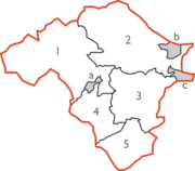
s (RDs) in place of the sanitary districts. Directly elected urban and rural district councils became the governing bodies. The new districts were identical to the sanitary districts, with the exception that where a RSD was divided by a county boundary it was split into separate rural district in each county. Radnorshire was divided into eight UDs and RDs, which were unchanged until their abolition in 1974:
- Colwyn RDColwyn Rural DistrictColwyn was, from 1894 to 1974, a rural district in the administrative county of Radnorshire, Wales.The district was formed by the Local Government Act 1894, when the existing Builth Rural Sanitary District was divided into two: the section in Breconshire was reconstituted as Builth Rural District...
(from Builth RSD) - Knighton RDKnighton Rural DistrictKnighton was, from 1894 to 1974, a rural district in the administrative county of Radnorshire, Wales.The district was formed by the Local Government Act 1894, when the existing Knighton Rural Sanitary District was divided into three: the section in Herefordshire was reconstituted as Wigmore Rural...
- Knighton UD
- Llandrindod Wells UD
- New Radnor RDNew Radnor Rural DistrictNew Radnor was, from 1894 to 1974, a rural district in the administrative county of Radnorshire, Wales.The district was formed by the Local Government Act 1894, when the existing Kington Rural Sanitary District was divided into two: the section in Herefordshire was reconstituted as Kington Rural...
(from Kington RSD) - Painscastle RDPainscastle Rural DistrictPainscastle was, from 1894 to 1974, a rural district in the administrative county of Radnorshire, Wales.The district was formed by the Local Government Act 1894, when the existing Hay Rural Sanitary District was divided into three: the section in Breconshire was reconstituted as Hay Rural District,...
(from Hay RSD) - Presteigne UD
- Rhayader RDRhayader Rural DistrictRhayader was, from 1894 to 1974, a rural district in the administrative county of Radnorshire, Wales.The district was formed by the Local Government Act 1894, based on the existing Rhayader Rural Sanitary District...
Coat of arms
Until 1954 Radnorshire County Council used a version of the arms of the MortimersRanulph de Mortimer
Ranulph I de Mortimer of Mortemer-sur-Eaulne, was a Marcher Lord from the Montgomery lands in the Welsh Marches. In England, he was Lord of Wigmore in Herefordshire. In Normandy, he was the Seigneur of St. Victor-en-Caux. Ranulph was the founder of the English House of Mortimer of Wigmore...
, Earls of March: Barry of six or and azure on a chief of the last two pallets azure between as may gyrons of the first. The council received a grant of armorial bearings
Coat of arms
A coat of arms is a unique heraldic design on a shield or escutcheon or on a surcoat or tabard used to cover and protect armour and to identify the wearer. Thus the term is often stated as "coat-armour", because it was anciently displayed on the front of a coat of cloth...
by the College of Arms
College of Arms
The College of Arms, or Heralds’ College, is an office regulating heraldry and granting new armorial bearings for England, Wales and Northern Ireland...
in 1954. The arms were made up of charges
Charge (heraldry)
In heraldry, a charge is any emblem or device occupying the field of an escutcheon . This may be a geometric design or a symbolic representation of a person, animal, plant, object or other device...
from local families. A gold reguardant lion on red was for Elystan Glodrhydd, Prince of Wales
Prince of Wales
Prince of Wales is a title traditionally granted to the heir apparent to the reigning monarch of the United Kingdom of Great Britain and Northern Ireland and the 15 other independent Commonwealth realms...
c.1000; black boars' heads on white for his son Cadwgan. Around these was placed a gold and blue compony bordure based on the Mortimer arms. The motto adopted by the county council was (Go Higher). In 1974 the arms were transferred to Radnor District Council. In 1996 the arms were transferred a second time to Powys County Council, for use by the Radnorshire Shire Committee.
History and culture
The geographic territory of the historic county roughly corresponds with the Welsh territory of Rhwng Gwy a HafrenRhwng Gwy a Hafren
Rhwng Gwy a Hafren was a region of medieval Wales, located in the Welsh Marches between Powys to the north and Brycheiniog to the south. It was bounded by the rivers Wye and Severn , hence its name. It covered approximately the same territory as Radnorshire, now part of the county of Powys...
which fell under the control of the Marcher Lords
Welsh Marches
The Welsh Marches is a term which, in modern usage, denotes an imprecisely defined area along and around the border between England and Wales in the United Kingdom. The precise meaning of the term has varied at different periods...
at the end of the 11th Century. Radnorshire was a poor county and has been an historical backwater but occasionally has drifted to the forefront of history. The most notable historic events are the Battle of Bryn Glas
Battle of Bryn Glas
The Battle of Bryn Glas, was fought on 22 June 1402, near the towns of Knighton and Presteigne in Powys...
fought on June 22, 1402 during the rebellion of Owain Glyndŵr
Owain Glyndwr
Owain Glyndŵr , or Owain Glyn Dŵr, anglicised by William Shakespeare as Owen Glendower , was a Welsh ruler and the last native Welshman to hold the title Prince of Wales...
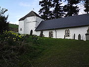
, and the founding of Cwmhir Abbey
Cwmhir Abbey
Cwmhir Abbey , near Llandrindod Wells in Powys, is a Welsh Cistercian monastery founded in 1176 by Cadwallon ap Madog. A spurious tale was later recorded that the abbey was founded in 1143 by Meredudd ap Maelgwn at Ty-faenor, and then refounded at the present location near the village of...
.
The county's poverty was remarked upon thus in the 17th century by an anonymous visitor:
Apart from a handful of parishes along the English border the Welsh language
Welsh language
Welsh is a member of the Brythonic branch of the Celtic languages spoken natively in Wales, by some along the Welsh border in England, and in Y Wladfa...
remained the first language of the county well into the second half of the eighteenth century. By 1850 the language had retreated to the western parishes of Rhayader
Rhayader
Rhayader is a market town and community in Powys, Mid Wales. It has a population of 2,075, and is the first town on the banks of the River Wye, from its source on the Plynlimon range of the Cambrian Mountains....
, Llanyre
Llanyre
Llanyre is a village in Powys, Wales. The parish had a population of 1,061 as of 2001. -Location:Llanyre is to the west of Llandrindod Wells, in the upper Wye Valley...
, Cwmdauddwr
Cwmdauddwr
Cwmdauddwr is a village in Powys, Wales.It is contiguous with the town of Rhayader on the opposite side of the River Wye...
, St Harmon
St Harmon
St Harmon is a village in Powys, Wales. It is located on the River Marteg on the B4518 road running between Llanidloes and Rhayader.St Harmon FC is the village football team.- External links :*...
and Nantmel. By 1900 Welsh was still spoken by a sizeable minority west of the town of Rhayader
Rhayader
Rhayader is a market town and community in Powys, Mid Wales. It has a population of 2,075, and is the first town on the banks of the River Wye, from its source on the Plynlimon range of the Cambrian Mountains....
, the language disappearing as the century progressed. Of course there were Welsh speakers living in Radnorshire who had come from other parts of Wales and today their number has been swelled by children being educated through the medium of Welsh in school.
Until the Acts of Union, Radnor was outside the Principality of Wales
Principality of Wales
The Principality of Wales existed between 1216 and 1542, encompassing two-thirds of modern Wales.It was formally founded in 1216 at the Council of Aberdyfi, and later recognised by the 1218 Treaty of Worcester between Llywelyn the Great of Wales and Henry III of England...
. This peculiar Marcher status and its want of Welsh speakers gave weight to the traditional local expression, "Neither Wales nor England, just Radnorsheer"
Places of special interest
- Abbey Cwmhir aka AbbeycwmhirAbbeycwmhirAbbeycwmhir or Abbey Cwmhir is a village in the valley of the Clywedog brook in Powys, Wales.- The Abbey :The village is named after Cwmhir Abbey, the Cistercian abbey built there in 1143. It was the largest Abbey in Wales but was never completed. Its fourteen bay nave was longer than Canterbury...
; - BeguildyBeguildyBeguildy is a village in mid Wales. It lies in a remote tract of countryside, on the B4355 8 miles north west of Knighton, Powys and on the road to Newtown. It lies near the headwaters of the River Teme and is 235 metres above sea level...
Tumuli ; - Broadheath House, PresteignePresteignePresteigne is a town and community in Powys, Wales. It was the county town of the historic county of Radnorshire, and is in the Diocese of Hereford...
; - Elan ValleyElan ValleyThe Elan Valley is a river valley situated to the west of Rhayader, in Powys, Wales, sometimes known as the "Welsh Lake District". It covers of lake and countryside....
Visitor's Centre ; - The Pales ;
- Offa's DykeOffa's DykeOffa's Dyke is a massive linear earthwork, roughly followed by some of the current border between England and Wales. In places, it is up to wide and high. In the 8th century it formed some kind of delineation between the Anglian kingdom of Mercia and the Welsh kingdom of Powys...
; - The Rock Park, Llandrindod WellsLlandrindod WellsLlandrindod Wells , colloquially known locally as "Llandod", is a town and community in Powys, within the historic boundaries of Radnorshire, mid Wales, United Kingdom. It was developed as a spa town in the 19th century, with a boom in the late 20th century as a centre of local government. Before...
. - Royal Welsh ShowRoyal Welsh ShowThe Royal Welsh Show is the biggest agricultural show in Europe. It is organised by the Royal Welsh Agricultural Society, which was formed in 1904, and takes place in July of each year, at Llanelwedd, near Builth Wells, in Powys, Mid Wales....
ground, LlanelweddLlanelweddLlanelwedd is a village near Builth Wells, in Powys, Wales. It lies within the historic boundaries of the former county of Radnorshire.-Location and geography:... - PillethPillethPilleth is a small village south of Knighton in Powys, Wales. It is the site of the ancient church and holy well of St. Mary’s which stands on Bryn Glas Hill overlooking the River Lugg, as it makes it way to Presteigne.-Name:...
Church and the Battle of Bryn GlasBattle of Bryn GlasThe Battle of Bryn Glas, was fought on 22 June 1402, near the towns of Knighton and Presteigne in Powys...
Principal towns and villages
No centre in Radnorshire exceeds a population of 6,000; only one (Llandrindod Wells) exceeds 5,000:- Knighton
- Llandrindod WellsLlandrindod WellsLlandrindod Wells , colloquially known locally as "Llandod", is a town and community in Powys, within the historic boundaries of Radnorshire, mid Wales, United Kingdom. It was developed as a spa town in the 19th century, with a boom in the late 20th century as a centre of local government. Before...
- PresteignePresteignePresteigne is a town and community in Powys, Wales. It was the county town of the historic county of Radnorshire, and is in the Diocese of Hereford...
- RhayaderRhayaderRhayader is a market town and community in Powys, Mid Wales. It has a population of 2,075, and is the first town on the banks of the River Wye, from its source on the Plynlimon range of the Cambrian Mountains....
- Newbridge on Wye
- New RadnorNew RadnorNew Radnor is a village in Powys, mid Wales. It was the original county town of Radnorshire. The population today is around 400, a higher than normal proportion of which are pensioners...
Radnorshire Diaspora
Poverty and agricultural change, decline and industrial progress elsewhere has always made Radnorshire a place of net emigration. Emigrants employed the name of the county in the USA- Radnor Lake State Park, Nashville, TennesseeNashville, TennesseeNashville is the capital of the U.S. state of Tennessee and the county seat of Davidson County. It is located on the Cumberland River in Davidson County, in the north-central part of the state. The city is a center for the health care, publishing, banking and transportation industries, and is home...
- Radnor Township, Delaware County, Pennsylvania. Part of the Welsh TractWelsh TractThe Welsh Tract, also called the Welsh Barony, was a portion of the U.S. state of Pennsylvania settled largely by Welsh-speaking Quakers. It covers 40,000 acres to the west of Philadelphia...
first settled in 1663–1665 by a group of 40 Quakers from Radnorshire. - Radnor Township, Delaware County, OhioRadnor Township, Delaware County, OhioRadnor Township is one of the eighteen townships of Delaware County, Ohio, United States. The 2000 census found 1,335 people in the township.-Geography:Located in the northwestern part of the county, it borders the following townships:...
Others may have formed part of the Welsh community in Patagonia
Welsh settlement in Argentina
Y Wladfa refers to the Welsh settlement in Argentina, which began in 1865 and occurred mainly along the coast of Chubut Province in the far southern region of Patagonia...
.
See also
- List of Lord Lieutenants of RadnorshireLord Lieutenant of RadnorshireThis is a list of people who have served as Lord-Lieutenant of Radnorshire. After 1715, all Lord Lieutenants were also Custos Rotulorum of Radnorshire...
- List of High Sheriffs of RadnorshireHigh Sheriff of Radnorshire- History :The office of High Sheriff is over 1000 years old, with its establishment before the Norman Conquest. The Office of High Sheriff remained first in precedence in the counties until the reign of Edward VII when an Order in Council in 1908 gave the Lord-Lieutenant the prime office under the...
- Radnorshire (UK Parliament constituency)Radnorshire (UK Parliament constituency)Radnorshire was created in 1542 as a constituency of the House of Commons of the Parliament of England then of the Parliament of Great Britain from 1707 to 1800 and of the Parliament of the United Kingdom from 1801 to 1918...
- A list of MPs - Red Kite feeding in WalesRed Kite feeding in WalesRed Kites in some parts of mid-Wales are regularly fed by humans. This has a dual purpose: it is intended to help sustain and increase the kite population through the provision of extra food, and it also acts as a tourism draw....