

Radar navigation
Encyclopedia
Corner reflector
A corner reflector is a retroreflector consisting of three mutually perpendicular, intersecting flat surfaces, which reflects waves back directly towards the source, but shifted . Unlike a simple mirror, they work for a relatively wide-angle field of view. The three intersecting surfaces often have...
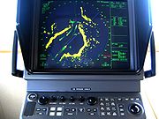
, the navigator can take distances and angular bearings to charted objects and use these to establish arcs of position and lines of position on a chart. A fix consisting of only radar information is called a radar fix.
Some types of radar fixes include the relatively self-explanatory methods of "range and bearing to a single object," "two or more bearings," "tangent bearings," and "two or more ranges."
Parallel indexing is a technique defined by William Burger in the 1957 book The Radar Observer's Handbook.National Imagery and Mapping Agency, 2001:169. This technique involves creating a line on the screen that is parallel to the ship's course, but offset to the left or right by some distance. This parallel line allows the navigator to maintain a given distance away from hazards.
Some techniques have been developed for special situations. One, known as the "contour method," involves marking a transparent plastic template on the radar screen and moving it to the chart to fix a position.National Imagery and Mapping Agency, 2001:164.
Another special technique, known as the Franklin Continuous Radar Plot Technique, involves drawing the path a radar object should follow on the radar display if the ship stays on its planned course.National Imagery and Mapping Agency, 2001:182. During the transit, the navigator can check that the ship is on track by checking that the pip lies on the drawn line.
The Yeoman Plotter
Yeoman Plotter
The Yeoman Plotter is a plotter used on ships and boats, which allows GPS and radar navigation data to be used much more effectively with traditional paper charts...
uses both radar, GPS and traditional charts to plot coarses and is one of the most used plotters today.
After completing the plotting radar technique, the image from the radar can either be displayed, captured or recorded to a computer monitor using a frame grabber
Frame grabber
A frame grabber is an electronic device that captures individual, digital still frames from an analog video signal or a digital video stream. It is usually employed as a component of a computer vision system, in which video frames are captured in digital form and then displayed, stored or...
.
See also
- Air navigationAir navigationThe basic principles of air navigation are identical to general navigation, which includes the process of planning, recording, and controlling the movement of a craft from one place to another....
- Austronesian navigationAustronesian navigationThe Austronesians were some of the early people that crossed vast open seas and settled farflung islands in search of new land to settle. The Austronesian expansion around 2500 BC and onwards is widely considered by some contemporary scholars to be one of the great movements of population in history....
- Celestial navigationCelestial navigationCelestial navigation, also known as astronavigation, is a position fixing technique that has evolved over several thousand years to help sailors cross oceans without having to rely on estimated calculations, or dead reckoning, to know their position...
- Dead reckoningDead reckoningIn navigation, dead reckoning is the process of calculating one's current position by using a previously determined position, or fix, and advancing that position based upon known or estimated speeds over elapsed time, and course...
- ECDIS
- Galileo positioning systemGalileo positioning systemGalileo is a global navigation satellite system currently being built by the European Union and European Space Agency . The €20 billion project is named after the famous Italian astronomer Galileo Galilei...
- Geodetic systemGeodetic systemGeodetic systems or geodetic data are used in geodesy, navigation, surveying by cartographers and satellite navigation systems to translate positions indicated on their products to their real position on earth....
- Great-circle distanceGreat-circle distanceThe great-circle distance or orthodromic distance is the shortest distance between any two points on the surface of a sphere measured along a path on the surface of the sphere . Because spherical geometry is rather different from ordinary Euclidean geometry, the equations for distance take on a...
- Marshall Islands stick chartMarshall Islands stick chartStick charts were made and used by the Marshallese to navigate the Pacific Ocean by canoe off the coast of the Marshall Islands. The charts represented major ocean swell patterns and the ways the islands disrupted those patterns, typically determined by sensing disruptions in ocean swells by...
- Off-course navigation
- Polynesian navigationPolynesian navigationPolynesian navigation is a system of navigation used by Polynesians to make long voyages across thousands of miles of open ocean. Navigators travel to small inhabited islands using only their own senses and knowledge passed by oral tradition from navigator to apprentice, often in the form of song...
- Radio navigationRadio navigationRadio navigation or radionavigation is the application of radio frequencies to determine a position on the Earth. Like radiolocation, it is a type of radiodetermination.The basic principles are measurements from/to electric beacons, especially...
- Yeoman PlotterYeoman PlotterThe Yeoman Plotter is a plotter used on ships and boats, which allows GPS and radar navigation data to be used much more effectively with traditional paper charts...
, one of the most used radar plotter systems - Franz Xaver, Baron Von Zach, a scientific editor and astronomer, first located many places geographically.