

Racetrack Playa
Encyclopedia
The Racetrack Playa, or The Racetrack, is a scenic dry lake
feature with "sailing stones
" that leave linear "racetrack" imprints. It is located above the northwestern side of Death Valley
, in Death Valley National Park
, Inyo County, California
, U.S..
, and 2.8 miles (4.5 km) long (north-south) by 1.3 miles (2 km) wide (east-west). It is also exceptionally flat and level with the northern end being only 1.5 inches (4 cm) higher than the southern. The highest point surrounding it is 5,678 feet (1731 m) high Ubehebe Peak, rising 1970 feet (571 m) above the lakebed 0.85 mile (1.37 km) to the west.
The playa
is in the small Racetrack Valley endorheic basin between the Cottonwood Mountains
on the east and Nelson Range
to the west. During periods of heavy rain, water washes down from the mountains onto the playa, forming a shallow, short-lived endorheic lake. Under the hot desert sun the thin veneer of water quickly evaporates leaving behind a surface layer of soft slick mud. As the mud dries it shrinks and cracks into a mosaic
pattern of interlocking polygon
s.
The shape of the shallow hydrocarbon lake Ontario Lacus
on Saturn's moon Titan
has been compared to that of Racetrack Playa.
. When dry, its surface is covered with small but firm hexagonal mud crack saucers that are typically 3 to 4 inches (7.5 to 10 cm) in diameter and about an inch (2.5 cm) thick. During the bimodal rainy season (summer and especially winter) a shallow cover of water deposits a thin layer of fine mud on and between the saucers of Racetrack. Heavier winter precipitation temporarily erases them until spring when the dry conditions cause new mud cracks to form where the old ones had been. Sandblasting wind continually helps to round the edges of exposed saucers. Annual precipitation is 3 to 4 inches (75 to 100 mm) and ice cover can be 1 to 2.5 inches (2.5 to 6.5 cm) thick. Typically only part of the playa will flood in any given year.
are a geological phenomenon found in the Racetrack. The stones slowly move across the surface of the playa, leaving a track as they go, without human or animal intervention. They have never been seen or filmed in motion.
Racetrack stones only move once every two or three years and most tracks last for three or four years. Stones with rough bottoms leave straight striated tracks while those with smooth bottoms wander. Stones sometimes turn over, exposing another edge to the ground and leaving a different-sized track in the stone's wake.
The sailing stones are most likely moved by strong winter winds, reaching 90 mph, once it has rained enough to fill the playa with just enough water to make the clay slippery. The prevailing southwest winds across Racetrack playa blow to northeast. Most of the rock trails are parallel to this direction, lending support to this hypothesis.
An alternate hypothesis builds upon the first. As rain water accumulates, strong winds blow thin sheets of water quickly over the relatively flat surface of the playa. A layer of ice forms on the surface as night temperatures fall below freezing. Wind then drives these floating ice sheets, their aggregate inertia and large area providing the necessary force required to move the larger stones. Rock trails would again remain parallel to the southwest winds. According to investigator Brian Dunning
, "Solid ice, moving with the surface of the lake and with the inertia of a whole surrounding ice sheet, would have no trouble pushing a rock along the slick muddy floor."
A more recent theory is that ice collars form around rocks and when the local water level rises, the rocks are buoyantly floated off the soft bed. The minimal friction allows the rocks to be moved by arbitrarily light winds.
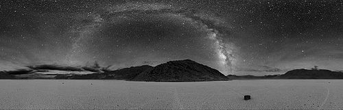
s rise dramatically above the playa's surface at its northern end. The larger landmark is The Grandstand
, a 73 feet (22 m) high dark outcrop, rising in dramatic contrast from the bright white surface of the Racetrack. The second 'island' feature is a smaller carbonate
outcrop.
. The 28 mile rough gravel road heading south-west from Ubehebe Crater
is passable with non-4WD vehicles but requires off-road compatibility. It rounds the western side of the playa to a parking area with descriptive signs by the National Park Service
. A bench here, placed by the Mano Seca Group, has scenic views of The Racetrack, The Grandstand, and mountain scenery.
Another access to Racetrack Playa is Lippincott pass road that enters the Racetrack valley from the south west, climbing up from Saline Valley. Lippincott Pass and the roads in Saline Valley are extremely rough and negotiable for the most off-road compatible of 4WD vehicles only.
Camping, while not allowed on the playa, is available in "primitive campsite" areas to the north and south.
Visiting remote areas of Death Valley bears considerable risk. Summer temperatures can surpass 120ºF, large areas are without cellphone reception, roads are treacherous and the closest gas station is in Furnace Creek
.
Dry lake
Dry lakes are ephemeral lakebeds, or a remnant of an endorheic lake. Such flats consist of fine-grained sediments infused with alkali salts. Dry lakes are also referred to as alkali flats, sabkhas, playas or mud flats...
feature with "sailing stones
Sailing stones
Sailing stones, sliding rocks, and moving rocks all refer to a geological phenomenon where rocks move in long tracks along a smooth valley floor without human or animal intervention. They have been recorded and studied in a number of places around Racetrack Playa, Death Valley, where the number and...
" that leave linear "racetrack" imprints. It is located above the northwestern side of Death Valley
Death Valley
Death Valley is a desert valley located in Eastern California. Situated within the Mojave Desert, it features the lowest, driest, and hottest locations in North America. Badwater, a basin located in Death Valley, is the specific location of the lowest elevation in North America at 282 feet below...
, in Death Valley National Park
Death Valley National Park
Death Valley National Park is a national park in the U.S. states of California and Nevada located east of the Sierra Nevada in the arid Great Basin of the United States. The park protects the northwest corner of the Mojave Desert and contains a diverse desert environment of salt-flats, sand dunes,...
, Inyo County, California
Inyo County, California
-National protected areas:* Death Valley National Park * Inyo National Forest * Manzanar National Historic Site-Major highways:* U.S. Route 6* U.S. Route 395* State Route 127* State Route 136* State Route 168* State Route 178...
, U.S..
Geography
The Racetrack playa is 3608 feet (1130 m) above sea levelSea level
Mean sea level is a measure of the average height of the ocean's surface ; used as a standard in reckoning land elevation...
, and 2.8 miles (4.5 km) long (north-south) by 1.3 miles (2 km) wide (east-west). It is also exceptionally flat and level with the northern end being only 1.5 inches (4 cm) higher than the southern. The highest point surrounding it is 5,678 feet (1731 m) high Ubehebe Peak, rising 1970 feet (571 m) above the lakebed 0.85 mile (1.37 km) to the west.
The playa
Dry lake
Dry lakes are ephemeral lakebeds, or a remnant of an endorheic lake. Such flats consist of fine-grained sediments infused with alkali salts. Dry lakes are also referred to as alkali flats, sabkhas, playas or mud flats...
is in the small Racetrack Valley endorheic basin between the Cottonwood Mountains
Cottonwood Mountains
The Cottonwood Mountains range is found in Death Valley National Park in Inyo County, California, U.S.The range lies just to the northwest of the Panamint Range at the top of Death Valley, and run in a north-south direction....
on the east and Nelson Range
Nelson Range (California)
The Nelson Range is a mountain range in the "Northern Mojave-Mono Lake region" of Inyo County, California, in Death Valley National Park.-Geography:...
to the west. During periods of heavy rain, water washes down from the mountains onto the playa, forming a shallow, short-lived endorheic lake. Under the hot desert sun the thin veneer of water quickly evaporates leaving behind a surface layer of soft slick mud. As the mud dries it shrinks and cracks into a mosaic
Mosaic
Mosaic is the art of creating images with an assemblage of small pieces of colored glass, stone, or other materials. It may be a technique of decorative art, an aspect of interior decoration, or of cultural and spiritual significance as in a cathedral...
pattern of interlocking polygon
Polygon
In geometry a polygon is a flat shape consisting of straight lines that are joined to form a closed chain orcircuit.A polygon is traditionally a plane figure that is bounded by a closed path, composed of a finite sequence of straight line segments...
s.
The shape of the shallow hydrocarbon lake Ontario Lacus
Ontario Lacus
Ontario Lacūs is a lake composed of methane, ethane and propane near the south pole of Saturn's moon Titan. Its character as a hydrocarbon lake was confirmed by observations from the Cassini spacecraft, published in the 31 July 2008 edition of Nature...
on Saturn's moon Titan
Titan (moon)
Titan , or Saturn VI, is the largest moon of Saturn, the only natural satellite known to have a dense atmosphere, and the only object other than Earth for which clear evidence of stable bodies of surface liquid has been found....
has been compared to that of Racetrack Playa.
The Racetrack
Racetrack is dry for almost the entire year and has no vegetationVegetation
Vegetation is a general term for the plant life of a region; it refers to the ground cover provided by plants. It is a general term, without specific reference to particular taxa, life forms, structure, spatial extent, or any other specific botanical or geographic characteristics. It is broader...
. When dry, its surface is covered with small but firm hexagonal mud crack saucers that are typically 3 to 4 inches (7.5 to 10 cm) in diameter and about an inch (2.5 cm) thick. During the bimodal rainy season (summer and especially winter) a shallow cover of water deposits a thin layer of fine mud on and between the saucers of Racetrack. Heavier winter precipitation temporarily erases them until spring when the dry conditions cause new mud cracks to form where the old ones had been. Sandblasting wind continually helps to round the edges of exposed saucers. Annual precipitation is 3 to 4 inches (75 to 100 mm) and ice cover can be 1 to 2.5 inches (2.5 to 6.5 cm) thick. Typically only part of the playa will flood in any given year.
Sailing stones
The sailing stonesSailing stones
Sailing stones, sliding rocks, and moving rocks all refer to a geological phenomenon where rocks move in long tracks along a smooth valley floor without human or animal intervention. They have been recorded and studied in a number of places around Racetrack Playa, Death Valley, where the number and...
are a geological phenomenon found in the Racetrack. The stones slowly move across the surface of the playa, leaving a track as they go, without human or animal intervention. They have never been seen or filmed in motion.
Racetrack stones only move once every two or three years and most tracks last for three or four years. Stones with rough bottoms leave straight striated tracks while those with smooth bottoms wander. Stones sometimes turn over, exposing another edge to the ground and leaving a different-sized track in the stone's wake.
The sailing stones are most likely moved by strong winter winds, reaching 90 mph, once it has rained enough to fill the playa with just enough water to make the clay slippery. The prevailing southwest winds across Racetrack playa blow to northeast. Most of the rock trails are parallel to this direction, lending support to this hypothesis.
An alternate hypothesis builds upon the first. As rain water accumulates, strong winds blow thin sheets of water quickly over the relatively flat surface of the playa. A layer of ice forms on the surface as night temperatures fall below freezing. Wind then drives these floating ice sheets, their aggregate inertia and large area providing the necessary force required to move the larger stones. Rock trails would again remain parallel to the southwest winds. According to investigator Brian Dunning
Brian Dunning (skeptic)
Brian Dunning is the host and producer of Skeptoid: Critical Analysis of Pop Phenomena, a weekly audio podcast dedicated "to furthering knowledge by blasting away the widespread pseudosciences that infect popular culture, and replacing them with evidence-based scientific reality." He is also the...
, "Solid ice, moving with the surface of the lake and with the inertia of a whole surrounding ice sheet, would have no trouble pushing a rock along the slick muddy floor."
A more recent theory is that ice collars form around rocks and when the local water level rises, the rocks are buoyantly floated off the soft bed. The minimal friction allows the rocks to be moved by arbitrarily light winds.
Islands
Two islands of bedrock OutcropOutcrop
An outcrop is a visible exposure of bedrock or ancient superficial deposits on the surface of the Earth. -Features:Outcrops do not cover the majority of the Earth's land surface because in most places the bedrock or superficial deposits are covered by a mantle of soil and vegetation and cannot be...
s rise dramatically above the playa's surface at its northern end. The larger landmark is The Grandstand
The Grandstand
"The Grandstand" is a monolith located on the Racetrack Playa north of Death Valley in the Cottonwood Mountains of Death Valley National Park in Inyo County, California....
, a 73 feet (22 m) high dark outcrop, rising in dramatic contrast from the bright white surface of the Racetrack. The second 'island' feature is a smaller carbonate
Carbonate
In chemistry, a carbonate is a salt of carbonic acid, characterized by the presence of the carbonate ion, . The name may also mean an ester of carbonic acid, an organic compound containing the carbonate group C2....
outcrop.
Visiting
Access is via Racetrack Road, reached at the Grapevine Junction near Scotty's CastleScotty's Castle
Scotty's Castle is a two-story Mission Revival and Spanish Colonial Revival style villa located in the Grapevine Mountains of northern Death Valley in Death Valley National Park, California, U.S.. It is also known as Death Valley Ranch...
. The 28 mile rough gravel road heading south-west from Ubehebe Crater
Ubehebe Crater
Ubehebe Crater is a large volcanic crater of the Ubehebe Craters volcanic field in the northern half of Death Valley, in Death Valley National Park, California.-Geography:...
is passable with non-4WD vehicles but requires off-road compatibility. It rounds the western side of the playa to a parking area with descriptive signs by the National Park Service
National Park Service
The National Park Service is the U.S. federal agency that manages all national parks, many national monuments, and other conservation and historical properties with various title designations...
. A bench here, placed by the Mano Seca Group, has scenic views of The Racetrack, The Grandstand, and mountain scenery.
Another access to Racetrack Playa is Lippincott pass road that enters the Racetrack valley from the south west, climbing up from Saline Valley. Lippincott Pass and the roads in Saline Valley are extremely rough and negotiable for the most off-road compatible of 4WD vehicles only.
Camping, while not allowed on the playa, is available in "primitive campsite" areas to the north and south.
Visiting remote areas of Death Valley bears considerable risk. Summer temperatures can surpass 120ºF, large areas are without cellphone reception, roads are treacherous and the closest gas station is in Furnace Creek
Furnace Creek, California
Furnace Creek is a census-designated place in Inyo County, California, United States. The population was 24 at the 2010 census, down from 31 at the 2000 census. The elevation of the village is below sea level....
.
See also
- Geology of the Death Valley areaGeology of the Death Valley areaThe exposed geology of the Death Valley area presents a diverse and complex set of at least 23 formations of sedimentary units, two major gaps in the geologic record called unconformities, and at least one distinct set of related formations geologists call groups...
- Places of interest in the Death Valley areaPlaces of interest in the Death Valley areaPlaces of interest in the Death Valley area are mostly located within Death Valley National Park in eastern California.-Artist's Drive and Palette:...
External links
- Living Stones of Death Valley
- Video of the Living Stones of Death Valley
- USGS: Racetrack Playa
- Las piedras que se mueven solas valle de la muerte ( Español )
- The Sliding Rocks of Racetrack Playa
- The Mystery of the Rocks on the Racetrack at Death Valley
- Differential GPS/GIS analysis of the sliding rock phenomenon of Racetrack Playa, Death Valley National Park
- http://racetrackplaya.org
- http://skeptoid.com/episodes/4021Living Stones of Death Valley - An examination of the mysterious stones that move by themselves across the desert floor Skeptoid: Critical Analysis of Pop PhenomenaSkeptoidSkeptoid is a weekly podcast created and hosted by American skeptic and author Brian Dunning. The show follows an audio essay format, and is dedicated to the critical examination of pseudoscience and the paranormal....
]