

Quito
Encyclopedia
San Francisco de Quito, most often called Quito (ˈkito), is the capital city of Ecuador
in northwestern South America
. It is located in north-central Ecuador in the Guayllabamba river basin, on the eastern slopes of Pichincha, an active stratovolcano
in the Andes
mountains. With a population of 2,197,698 according to the last census (2001), and, as estimated by the municipality, approximately 2,504,991 in 2005, Quito is the second most populous city in Ecuador, after Guayaquil
. It is also the capital of the Pichincha province
and the seat of Metropolitan District of Quito. The canton recorded a population of 1,842,201 residents in the 2001 national census. In 2008, the city was designated as the headquarters of the Union of South American Nations.
The elevation of the city's central square
(Plaza de La Independencia or Plaza Grande) is 2800 metres (9,186.4 ft), making Quito the second-highest administrative capital city in the world (after La Paz
, Bolivia
), and the highest legal capital (ahead of Sucre
, also in Bolivia, and Bogotá
, Colombia
).
The central square of Quito is located about 25 kilometres (15.5 mi) south of the equator
; the city itself extends to within about 1 kilometre (0.621372736649807 mi) of zero latitude. A monument and museum marking the general location of the equator is known locally as la mitad del mundo
(the middle of the world), to avoid confusion, as the word is Spanish
for equator.
Quito, along with Kraków
, were the first World Cultural Heritage Sites declared by UNESCO
in 1978.
's 1767 book Historia del Reino de Quito, the Quitu were conquered by the Caras tribe
, who founded the Kingdom of Quito about 980 AD. For more than four centuries under the kings (shyris).
Caras and their allies were narrowly defeated in the epic battles of Tiocajas and Tixán in 1462, by an army of 250,000 led by Túpac Inca, the son of the Emperor of the Incas. After several decades of consolidation, the Kingdom of Quito became integrated into the Incan Empire. In 1534, the Caras/Quitu people were conquered by the Spanish.
continued during 1534, with Diego de Almagro
founding Santiago de Quito (in present day Cola, near Riobamba
) on August 15, 1534, later to be renamed San Francisco de Quito on August 28, 1534. The city was later moved to its present location and was refounded on 6 December 1534 by 204 settlers led by Sebastián de Benalcázar, who captured Rumiñahui
and effectively ended any organized resistance. Rumiñahui was then executed on January 10, 1535. On March 14, 1541, Quito was declared a city and on February 14, 1556, was given the title Muy Noble y Muy Leal Ciudad de San Francisco de Quito ("Very Noble and Loyal City of San Francisco of Quito"). In 1563, Quito became the seat of a royal audiencia (administrative district) of Spain and became part of the Viceroyalty of Peru
with its capital in Lima
(see Real Audiencia de Quito
).
As with other places colonized by the Christian Spanish invaders, the colonizers promptly established Roman Catholicism in Quito. The first church (El Belén) was in fact built even before the city had been officially founded. In January 1535, the San Francisco Convent was constructed, the first of about 20 churches and convents built during the colonial period. The Spanish forcibly converted the indigenous population to Christianity and used them as slave labor for construction. The Diocese of Quito was established in 1545 and was elevated to the Archdiocese of Quito in 1849.
In 1809, after nearly 300 years of Spanish colonization, Quito was a city of about 10,000 inhabitants. On August 10, 1809, a movement was started in Quito that aimed for political independence from Spain. On that date, a plan for government was established that placed Juan Pío Montúfar as president with various other prominent figures in other positions of government. However, this initial movement was ultimately defeated on August 2, 1810, when Imperial troops came from Lima
, Peru
, and killed the leaders of the uprising along with about 200 inhabitants of the city. A chain of conflicts concluded on May 24, 1822, when Antonio José de Sucre
, under the command of Simón Bolívar
, led troops into the Battle of Pichincha
. Their victory marked the independence of Quito and the surrounding areas.
began. Later, in 1875, the country's president, Gabriel García Moreno
, was assassinated in Quito. Two years later, in 1877, Archbishop José Ignacio Checa y Barba was killed by poisoning while he was giving mass.
In 1882, insurgents arose against the regime of dictator Ignacio de Veintemilla
. However, this did not end the violence that was occurring throughout the country. On July 9, 1883, the liberal commander Eloy Alfaro
participated in the Battle of Guayaquil
, and later, after more conflict, became the president of Ecuador on September 4, 1895. Upon completing his second term in 1911, he moved to Europe
. When he returned to Ecuador in 1912 and attempted a return to power, he was arrested on January 28, 1912; thrown in prison; and assassinated by a mob
that had stormed the prison. His body was dragged through the streets of Quito to a city park, where it was burned.
In 1932, the Four Days' War broke out. This was a civil war that followed the election of Neptalí Bonifaz and the subsequent realization that he carried a Peruvian passport. Workers at a major textile factory went on strike in 1934, and similar unrest continues to the present day. On February 12, 1949, a realistic broadcast of H. G. Wells
' novel The War of the Worlds led to citywide panic and the deaths of more than twenty people who died in fires set by mobs.
.
Between 2003 and 2004, the bus lines of the Metrobus were constructed, traversing the city from the north to the south. Many avenues and roads were extended and enlarged, depressed passages were constructed, and roads were restructured geometrically to increase the flow of traffic.
In recent years, Quito has been the focal point of large demonstrations that led to the ousting of presidents Abdalá Bucaram
(February 5, 1997), Jamil Mahuad
(January 21, 2000), and Lucio Gutiérrez
(April 20, 2005).
of Ecuador
in the Guayllabamba
river basin. The city has been built on a long plateau lying on the east flanks of the Pichincha volcano. The valley of Guayllabamba River where Quito lies is flanked by volcanoes, some of them snow-capped, that can be visible from the city on a clear day. Some of the volcanoes on the Central Cordillera (Royal Cordillera), east of Quito, surrounding the Guayllabamba valley are Cotopaxi
, Sincholagua, Antisana
, and Cayambe
. Some of the volcanoes of the Western Cordillera, to the west of the Guayllabamba valley, are Illiniza
, Atacazo
, Pichincha
, and Pululahua (which has the Pululahua Geobotanical Reserve
). Interestingly, Quito is the closest Capital City
of a Country to the Equator
.
and Guagua Pichincha at 4,794 metres. Guagua Pichincha is active and being monitored by volcanologists at the geophysical institute of the national polytechnic university. The largest eruption occurred in 1660 when more than 25 centimetres (10 in) of ash covered the city. There were three minor eruptions in the 19th century. The latest eruption was recorded on August 23, 2006, when a few puffs of smoke and a large amount of ash were deposited on the city. Although not devastating, the eruption caused significant disruption of activities, including closing of the international airport. It is unlikely that any serious activity will occur in the near future, and the topography of the volcano is such that, even if a major eruption were to occur, lava flows would head into the almost-unpopulated areas west of the volcano, sparing Quito, which lies to the east.
Activity in other nearby volcanoes also can affect the city. In November 2002, after an eruption in the volcano Reventador
, the city was showered with a layer of fine ash particles to a depth of several centimeters.
, Quito has a subtropical highland climate. Because of its elevation and its proximity to the equator, Quito has a fairly constant cool climate, with spring-like weather year-round. The average temperature at noon is 18.7 °C (65.7 °F) with a normal night-time low of 9.3 °C (48.7 °F). The annual average temperature is 14 °C (57.2 °F). The city experiences only two seasons: dry and wet. The dry season, June through September (4 months), is referred to as summer; the wet season, October through May (8 months), is referred to as winter. Annual precipitation, depending on location, is approximately 1010 mm (39.8 in)
TAME
, an airline of Ecuador, has its headquarters in Quito.
As of 2008, the municipality of Quito divided the city into 32 urban parishes. These parishes, which are used by the municipality for administrative purposes, are also known as cabildos since 2001. Since the times of the Metropolitan District of Quito, parishes of this type are also grouped into larger divisions known as municipal zones (zonas municipales). These parishes are as follows:
 Electoral urban parishes are used by the Consejo Nacional Electoral (CNE) (until the 2008 Ecuadorian constitution known as Tribunal Supremo Electoral (TSE)) and by the Tribunal Electoral de Pichincha (TEP) in order to distribute vote ballots and count electoral votes. Unlike rural parishes, urban parishes do not have and do not elect a junta parroquial (parochial committee/junta). Within each of these parishes, there are one or more schools in which elections take place, typically on Sundays. , there were 19 urban parishes of this type, as follows:
Later in 2008, the relatively small González Suárez parish was removed from the list, prior to the 2009 elections.
network, also known as "Red Integrada de Transporte Público", is the bus rapid transit
system running in Quito, and it goes through the city from south to north. It's divided into three sections—the green line (the central trolleybus, known as El Trole), the red line (the north-east Ecovía), and the blue line (the north-west Corridor Central). In addition to the bus rapid transit
system, there are many buses running in the city. The buses have both a name and a number, and they have a fixed route. Taxi cabs are all yellow, and they have meters that show the fare. There are nearly 8,800 registered taxicab
s.
Because of growing road congestion in many areas, there were plans to construct a light rail
system, which were conceived to replace the northern portion of the Trole. This plans have been ruled out and replaced by the construction of the first metro line (subway) in 2012. It is expected to be operational by 2016 joining to the existing public transportation network.
Roads, avenues and streets
Because Quito is about 40 km (24.9 mi) long and 5 km (3.1 mi) at its widest, most of the important avenues of the city extend from north to south. The two main motorways that go from the northern part of the city to the southern are Avenue Oriental (Corridor Periférico Oriental) on the eastern hills that border the city, and Avenue Occidental on the western side of the city on the Pichincha volcano. The street 10 de Agosto also runs north to south through most of the city, running down the middle of it. Because of the hills and the city's curved shape, a grid pattern is extremely difficult to imply. The historic centre of the city is based on a grid pattern, despite the hills, with the streets Venezuela, Chile, García Moreno, and Guayaquil being the most important.
(EFE). This form of transport is nowadays used mostly for tourism.
(IATA airport code: UIO) serves as the city's principal airport for passenger travel and freight. The airport is located 10 kilometres (6.2 mi) north of the city's centre, within driving distance to the main business center. Because of tall buildings and fog at night, landing from the south is not as easy as at many other airports. The construction of a new airport
in the rural parish of Tababela, in the adjacent valley outside the city limits, began in 2006 and will be finished by 2011. The Mariscal Sucre International Airport will then become a big park.
in Poland
, the first to be declared World Heritage Site
by UNESCO
on 18 September 1978. The Historic Centre of Quito is located in the center south of the capital on an area of 320 hectares (790.7 acre), and is considered one of the most important historic areas in Latin America.Ther are about 130 monumental buildings (which hosts a variety of pictorial art and sculpture, mostly of religious inspired in a multi-faceted range of schools and styles) and 5,000 properties registered in the municipal inventory of heritage properties. Unfortunately, for several years, some of this has been somewhat neglected, which contributed to the deterioration of many of the buildings and surrounding streets. This not only diminished beauty but also contributed to safety concerns. The Corporation of Development of the Historic Center's program is helping to restore the area.
Walking through the historic centre of Quito today, now that it has been almost completely restored, has again become a pleasant experience. The Corporation of Development of the Historic Center is responsible for the restoration and conservation of churches, streets, and plazas of this area. It has created several tourist sites that offer educational and historical value. To this end, members of the Municipal Police have been trained to serve as guides in those tours. At night, when the lights turn on in the city, one can stroll through downtown in a horse-drawn carriage in the colonial style. On the Plaza de la Independencia (also known as Plaza Grande) is the Palacio de Carondelet, the seat of the Presidency of the Republic.
during his visit to Ecuador on 18 January 1985.
One of the events that took place in this cathedral was the murder of the Bishop of Quito, José Ignacio Checa y Barba, who during the mass of Good Friday
on 30 March 1877 was poisoned with strychnine dissolved in the consecrate wine. The cathedral is also the burial place of the remains of the Grand Marshal
Antonio José de Sucre
and also of several presidents of the Republic, as well as of bishops and priests who died in the diocese. The cathedral is located on the south side of the Plaza de La Independencia
.
from Ecuador. Forty years later, in 1807, it was reopened by the Chilean Friar Camilo Henríquez
, of the order of Buenamuerte, who later took part in the fights for independence of his country.
This church is inspired by the Church of the Gesu
in Rome
. The columns are a copy of those made by Bernini in the Vatican. Inside, it has altarpieces and pulpits covered with gold leaf. The altarpiece, designed by Legarda, is the main reason for the composition of the facade the twisted columns and the cornices that stretch to the center in an arch, topped in a crown supported by angels. The church is located between the streets García Moreno and Antonio José de Sucre. 140 years after the earthquake that destroyed the bell tower of the Church of La Compañía de Jesús, the Municipality of Quito began re-building the 45-meter-high bell tower to its original specifications.
The church is located at the intersection of Benalcázar, Bolívar, Sucre and Cuenca streets. It is one block ahead of the church of La Compañía de Jesús.
by Father Carlos, the Saint John of God
by Caspicara, and the Saint Thomas Aquinas
by Legarda. Another Baroque piece that stands is the Chapel of Nuestra Señora del Rosario, which is a recognizable feature of the architecture of Quito. This chapel was built beside the church, in the gospel side. In this was founded the largest fraternity in the city of Quito.
is a hill located in the middle west of the city at an altitude of about 3016 metres (9,895 ft) above sea level
. A monument to the Virgin Mary is located on top of El Panecillo and is visible from most of the city of Quito. In 1976, the Spanish artist Agustín de la Herrán Matorras was commissioned by the religious order of the Oblate
s to build a 41 metres (134.5 ft)–tall aluminum monument of a madonna
, which was assembled on a high pedestal on the top of Panecillo. Made of approximately 7,000 pieces of aluminum, the monument was inaugurated on March 28, 1976, by the 11th archbishop
of Quito, Cardinal Pablo Muñoz Vega
.
at 1376 acres (5.6 km²) (as reference, New York's Central Park
is 843 acre (341 ha). The park is located in northern Quito, on the hill of Bellavista behind Estadio Olímpico Atahualpa
. The park is suited for mountain biking, walking, and running. Most of it is eucalyptus
forest with trails, but there also are numerous sculptures on display. The park has four sites that can be used for picnics or barbecues, and the eastern section has a view of Cotopaxi
, Antisana
, and the Guayllabamba river basin.
headed a great mass in the park during his visit to Ecuador in 1985. A giant cross has been built in this place.
La Carolina more or less resembles New York City's Central Park
, since both La Carolina and Central Park are surrounded by tall buildings in relation to the area of both parks.
, Eduardo Kingman
, and Gonzalo Endara Crow
. Otavaleños
sell traditional sweaters, ponchos, carpets, and jewelry.
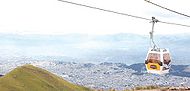 The Aerial tramway Station at Cruz Loma (part of the Pichincha mountain complex at about 4000 metres (13,123.4 ft)). Since July 2005, Quito has had an aerial tramway
, known as the "Telefériqo", from the city centre to the hill known as Cruz Loma on the east side of the Pichincha volcano. The ride takes visitors to an altitude of about 4100 metres (13,451.4 ft) where they find a number of restaurants, coffee shops, and a variety of stores. There are also trails for hiking and areas where pictures can be taken of Quito. Because of the increased altitude and the wind on the mountain, it is considerably cooler.
Besides the aerial tramway to Cruz Loma, the Telefériqo
as a whole is a visitor centre that includes an amusement park (Vulqano Park
), fine-dining restaurants, Go Karts, Paint Ball, shopping malls, an extensive food court, and other attractions.
 La Mitad del Mundo
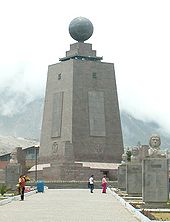
(the middle of the world) is a small village administered by the prefecture of the province of Pichincha, 35 kilometres (21.7 mi) north of Quito. The village features a large monument, built on the site where the equator was thought to have crossed in the early 1980s. There is also a museum that contains a model of Quito, a planetarium, various exhibits, several restaurants, an open arena that is occasionally used for folkloric-dance performances, and a small chapel where couples can marry with one spouse standing in the northern hemisphere and the other in the southern. It has since been determined, with the use of Global Positioning System
technology, that the actual equator is some 240 metres (787.4 ft) north of the monument area.
Pululahua Geobotanical Reserve
, located a few miles northwest from La Mitad del Mundo, contains the Pululahua volcano, whose caldera
(crater) is visible from a spot easily accessible by car. It is believed to be one of only a few in the world with human inhabitants.
Quito Zoo,
located near the rural parish of Guayllabamba
, about 20 kilometres (12.4 mi) outside Quito, has the biggest collection of native fauna in Ecuador, including several kinds of animals that are sometimes targeted in Ecuador in the illegal fur trade. The Zoo works in conservation and education in Ecuador and has successfully bred the endangered Andean condor.
Some of the other nearby natural attractions are:
 Quito is the home city of six prominent football clubs in Ecuador. Domestically, the city's top three club (El Nacional, Deportivo Quito and LDU Quito) have won a combined 26 national championships, which accounts for over half of all championships won.
Deportivo Quito
were the first Quito team to play in the league championship (in 1960, 3 years before El Nacional and LDU), they were also the first out of the big three to win the title. El Nacional
have won the joint most Series A titles with 13 championships (tied with Barcelona of Guayaquil). LDU Quito is the only Ecuadorian club to have won 4 international titles.
The teams in Ecuador's First Division (Serie A and Serie B) are:
with:
Madrid
, Spain
Buenos Aires
, Argentina
Bogotá
, Colombia
Managua
, Nicaragua
Louisville
, Kentucky
, USA Coral Gables, USA Vancouver
, Canada
La Paz
, Bolivia
Kraków
, Poland
Surabaya
, Indonesia
,(Since 5 July 2011)
Ecuador
Ecuador , officially the Republic of Ecuador is a representative democratic republic in South America, bordered by Colombia on the north, Peru on the east and south, and by the Pacific Ocean to the west. It is one of only two countries in South America, along with Chile, that do not have a border...
in northwestern South America
South America
South America is a continent situated in the Western Hemisphere, mostly in the Southern Hemisphere, with a relatively small portion in the Northern Hemisphere. The continent is also considered a subcontinent of the Americas. It is bordered on the west by the Pacific Ocean and on the north and east...
. It is located in north-central Ecuador in the Guayllabamba river basin, on the eastern slopes of Pichincha, an active stratovolcano
Stratovolcano
A stratovolcano, also known as a composite volcano, is a tall, conical volcano built up by many layers of hardened lava, tephra, pumice, and volcanic ash. Unlike shield volcanoes, stratovolcanoes are characterized by a steep profile and periodic, explosive eruptions...
in the Andes
Andes
The Andes is the world's longest continental mountain range. It is a continual range of highlands along the western coast of South America. This range is about long, about to wide , and of an average height of about .Along its length, the Andes is split into several ranges, which are separated...
mountains. With a population of 2,197,698 according to the last census (2001), and, as estimated by the municipality, approximately 2,504,991 in 2005, Quito is the second most populous city in Ecuador, after Guayaquil
Guayaquil
Guayaquil , officially Santiago de Guayaquil , is the largest and the most populous city in Ecuador,with about 2.3 million inhabitants in the city and nearly 3.1 million in the metropolitan area, as well as that nation's main port...
. It is also the capital of the Pichincha province
Pichincha Province
Pichincha is a province of Ecuador located in the northern sierra region; its capital and largest city is Quito. It is bordered by Imbabura & Esmeraldas to the north, Cotopaxi & Santo Domingo de los Tsáchilas to the south, Napo & Sucumbíos to the east, and Esmeraldas & Santo Domingo de los...
and the seat of Metropolitan District of Quito. The canton recorded a population of 1,842,201 residents in the 2001 national census. In 2008, the city was designated as the headquarters of the Union of South American Nations.
The elevation of the city's central square
Plaza de La Independencia
Independence Square, also known as Big Square . Historic public square of Quito , located in the heart of the old city. This is the central square of the city and one of the symbols of the executive power of the nation...
(Plaza de La Independencia or Plaza Grande) is 2800 metres (9,186.4 ft), making Quito the second-highest administrative capital city in the world (after La Paz
La Paz
Nuestra Señora de La Paz is the administrative capital of Bolivia, as well as the departmental capital of the La Paz Department, and the second largest city in the country after Santa Cruz de la Sierra...
, Bolivia
Bolivia
Bolivia officially known as Plurinational State of Bolivia , is a landlocked country in central South America. It is the poorest country in South America...
), and the highest legal capital (ahead of Sucre
Sucre
Sucre, also known historically as Charcas, La Plata and Chuquisaca is the constitutional capital of Bolivia and the capital of the department of Chuquisaca. Located in the south-central part of the country, Sucre lies at an elevation of 2750m...
, also in Bolivia, and Bogotá
Bogotá
Bogotá, Distrito Capital , from 1991 to 2000 called Santa Fé de Bogotá, is the capital, and largest city, of Colombia. It is also designated by the national constitution as the capital of the department of Cundinamarca, even though the city of Bogotá now comprises an independent Capital district...
, Colombia
Colombia
Colombia, officially the Republic of Colombia , is a unitary constitutional republic comprising thirty-two departments. The country is located in northwestern South America, bordered to the east by Venezuela and Brazil; to the south by Ecuador and Peru; to the north by the Caribbean Sea; to the...
).
The central square of Quito is located about 25 kilometres (15.5 mi) south of the equator
Equator
An equator is the intersection of a sphere's surface with the plane perpendicular to the sphere's axis of rotation and containing the sphere's center of mass....
; the city itself extends to within about 1 kilometre (0.621372736649807 mi) of zero latitude. A monument and museum marking the general location of the equator is known locally as la mitad del mundo
Mitad del Mundo
The Mitad del Mundo is a tract of land owned by the prefecture of the province of Pichincha, Ecuador. It is located in the San Antonio parish of the canton of Quito, north of the center of Quito....
(the middle of the world), to avoid confusion, as the word is Spanish
Spanish language
Spanish , also known as Castilian , is a Romance language in the Ibero-Romance group that evolved from several languages and dialects in central-northern Iberia around the 9th century and gradually spread with the expansion of the Kingdom of Castile into central and southern Iberia during the...
for equator.
Quito, along with Kraków
Kraków
Kraków also Krakow, or Cracow , is the second largest and one of the oldest cities in Poland. Situated on the Vistula River in the Lesser Poland region, the city dates back to the 7th century. Kraków has traditionally been one of the leading centres of Polish academic, cultural, and artistic life...
, were the first World Cultural Heritage Sites declared by UNESCO
UNESCO
The United Nations Educational, Scientific and Cultural Organization is a specialized agency of the United Nations...
in 1978.
Pre-Columbian
Quito's origins date back to the first millennium, when the Quitu tribe occupied the area and eventually formed a commercial center. According to Juan de VelascoJuan de Velasco
Juan de Velasco y Pérez Petroche was an 18th-century Jesuit priest, historian, and professor of philosophy and theology from the Royal Audience of Quito. He was born in Riobamba to Juan de Velasco y López de Moncayo and to María Pérez Petroche. Among the universities where he taught was the...
's 1767 book Historia del Reino de Quito, the Quitu were conquered by the Caras tribe
Caras (tribe)
The Cara culture flourished in coastal Ecuador, in what is now Manabí Province, in the first millennium CE.-History:In the 10th century CE, they followed the Esmeraldas River up to the high Andean valley now known as the city San Francisco de Quito. They defeated the local Quitu tribe and set up a...
, who founded the Kingdom of Quito about 980 AD. For more than four centuries under the kings (shyris).
Caras and their allies were narrowly defeated in the epic battles of Tiocajas and Tixán in 1462, by an army of 250,000 led by Túpac Inca, the son of the Emperor of the Incas. After several decades of consolidation, the Kingdom of Quito became integrated into the Incan Empire. In 1534, the Caras/Quitu people were conquered by the Spanish.
Colony
Indigenous resistance to the Spanish invasionSpanish colonization of the Americas
Colonial expansion under the Spanish Empire was initiated by the Spanish conquistadores and developed by the Monarchy of Spain through its administrators and missionaries. The motivations for colonial expansion were trade and the spread of the Christian faith through indigenous conversions...
continued during 1534, with Diego de Almagro
Diego de Almagro
Diego de Almagro, , also known as El Adelantado and El Viejo , was a Spanish conquistador and a companion and later rival of Francisco Pizarro. He participated in the Spanish conquest of Peru and is credited as the first European discoverer of Chile.Almagro lost his left eye battling with coastal...
founding Santiago de Quito (in present day Cola, near Riobamba
Riobamba
Riobamba is the capital of the Chimborazo Province in central Ecuador, which is located at the Chambo River Valley of the Andes. It is south of Ecuador's capital Quito and located at 2754 m on the Avenue of the Volcanoes...
) on August 15, 1534, later to be renamed San Francisco de Quito on August 28, 1534. The city was later moved to its present location and was refounded on 6 December 1534 by 204 settlers led by Sebastián de Benalcázar, who captured Rumiñahui
Rumiñahui (Inca warrior)
Rumiñahui, Ruminavi, Rumiñagui, or alternatively Rumiaoui, born late 15th century, died June 25, 1535, was an Inca warrior who, after the death of Emperor Atahualpa, led the resistance against the Spanish in the northern part of the Inca Empire in 1533.Born in Pillaro in the modern province of...
and effectively ended any organized resistance. Rumiñahui was then executed on January 10, 1535. On March 14, 1541, Quito was declared a city and on February 14, 1556, was given the title Muy Noble y Muy Leal Ciudad de San Francisco de Quito ("Very Noble and Loyal City of San Francisco of Quito"). In 1563, Quito became the seat of a royal audiencia (administrative district) of Spain and became part of the Viceroyalty of Peru
Viceroyalty of Peru
Created in 1542, the Viceroyalty of Peru was a Spanish colonial administrative district that originally contained most of Spanish-ruled South America, governed from the capital of Lima...
with its capital in Lima
Lima
Lima is the capital and the largest city of Peru. It is located in the valleys of the Chillón, Rímac and Lurín rivers, in the central part of the country, on a desert coast overlooking the Pacific Ocean. Together with the seaport of Callao, it forms a contiguous urban area known as the Lima...
(see Real Audiencia de Quito
Royal Audience of Quito
The Royal Audience of Quito was an administrative unit in the Spanish Empire which had political, military, and religious jurisdiction over territories that today include Ecuador, parts of northern Peru, parts of southern Colombia and parts of northern Brazil...
).
As with other places colonized by the Christian Spanish invaders, the colonizers promptly established Roman Catholicism in Quito. The first church (El Belén) was in fact built even before the city had been officially founded. In January 1535, the San Francisco Convent was constructed, the first of about 20 churches and convents built during the colonial period. The Spanish forcibly converted the indigenous population to Christianity and used them as slave labor for construction. The Diocese of Quito was established in 1545 and was elevated to the Archdiocese of Quito in 1849.
In 1809, after nearly 300 years of Spanish colonization, Quito was a city of about 10,000 inhabitants. On August 10, 1809, a movement was started in Quito that aimed for political independence from Spain. On that date, a plan for government was established that placed Juan Pío Montúfar as president with various other prominent figures in other positions of government. However, this initial movement was ultimately defeated on August 2, 1810, when Imperial troops came from Lima
Lima
Lima is the capital and the largest city of Peru. It is located in the valleys of the Chillón, Rímac and Lurín rivers, in the central part of the country, on a desert coast overlooking the Pacific Ocean. Together with the seaport of Callao, it forms a contiguous urban area known as the Lima...
, Peru
Peru
Peru , officially the Republic of Peru , is a country in western South America. It is bordered on the north by Ecuador and Colombia, on the east by Brazil, on the southeast by Bolivia, on the south by Chile, and on the west by the Pacific Ocean....
, and killed the leaders of the uprising along with about 200 inhabitants of the city. A chain of conflicts concluded on May 24, 1822, when Antonio José de Sucre
Antonio José de Sucre
Antonio José de Sucre y Alcalá , known as the "Gran Mariscal de Ayacucho" , was a Venezuelan independence leader. Sucre was one of Simón Bolívar's closest friends, generals and statesmen.-Ancestry:...
, under the command of Simón Bolívar
Simón Bolívar
Simón José Antonio de la Santísima Trinidad Bolívar y Palacios Ponte y Yeiter, commonly known as Simón Bolívar was a Venezuelan military and political leader...
, led troops into the Battle of Pichincha
Battle of Pichincha
The Battle of Pichincha took place on 24 May 1822, on the slopes of the Pichincha volcano, 3,500 meters above sea-level, right next to the city of Quito, in modern Ecuador....
. Their victory marked the independence of Quito and the surrounding areas.
Republican era
In 1833, members of the Society of Free Inhabitants of Quito were assassinated by the government after they conspired against it, and on March 6, 1845, the Marcist RevolutionMarcist Revolution
On March 6, 1845, the people of Guayaquil , Ecuador, revolted against the government of the General Juan José Flores under the leadership of General António Elizalde and Lieutenant-Colonel Fernándo Ayarza. The people took the artillery barracks of Guayaquil along with other military and civilian...
began. Later, in 1875, the country's president, Gabriel García Moreno
Gabriel García Moreno
Gabriel Gregorio Fernando José María García y Moreno y Morán de Buitrón was an Ecuadorian statesman who twice served as President of Ecuador and was assassinated during his second term, after being elected to a third term...
, was assassinated in Quito. Two years later, in 1877, Archbishop José Ignacio Checa y Barba was killed by poisoning while he was giving mass.
In 1882, insurgents arose against the regime of dictator Ignacio de Veintemilla
Ignacio de Veintemilla
Mario Ignacio Francisco Tomás Antonio de Veintimilla y Villacís was President of Ecuador 8 September 1876 to 26 January 1878 and 25 March 1882 to 9 July 1883 and de facto ruler from 8 September 1876 to 9 July 1883....
. However, this did not end the violence that was occurring throughout the country. On July 9, 1883, the liberal commander Eloy Alfaro
Eloy Alfaro
José Eloy Alfaro Delgado was the President of Ecuador from 1895 to 1901 and from 1906 to 1911. He became one the strongest opponents of pro-Catholic conservative President Gabriel Garcia Moreno...
participated in the Battle of Guayaquil
Battle of Guayaquil
The Battle of Guayaquil was the final and pivotal armed confrontation of the Ecuadorian Civil War. The battle was fought on the outskirts of the city of Guayaquil, Ecuador on September 22 – 24, 1860 among several factions claiming control of the country's territory in the wake of the abdication of...
, and later, after more conflict, became the president of Ecuador on September 4, 1895. Upon completing his second term in 1911, he moved to Europe
Europe
Europe is, by convention, one of the world's seven continents. Comprising the westernmost peninsula of Eurasia, Europe is generally 'divided' from Asia to its east by the watershed divides of the Ural and Caucasus Mountains, the Ural River, the Caspian and Black Seas, and the waterways connecting...
. When he returned to Ecuador in 1912 and attempted a return to power, he was arrested on January 28, 1912; thrown in prison; and assassinated by a mob
Gang
A gang is a group of people who, through the organization, formation, and establishment of an assemblage, share a common identity. In current usage it typically denotes a criminal organization or else a criminal affiliation. In early usage, the word gang referred to a group of workmen...
that had stormed the prison. His body was dragged through the streets of Quito to a city park, where it was burned.
In 1932, the Four Days' War broke out. This was a civil war that followed the election of Neptalí Bonifaz and the subsequent realization that he carried a Peruvian passport. Workers at a major textile factory went on strike in 1934, and similar unrest continues to the present day. On February 12, 1949, a realistic broadcast of H. G. Wells
H. G. Wells
Herbert George Wells was an English author, now best known for his work in the science fiction genre. He was also a prolific writer in many other genres, including contemporary novels, history, politics and social commentary, even writing text books and rules for war games...
' novel The War of the Worlds led to citywide panic and the deaths of more than twenty people who died in fires set by mobs.
21st Century
From the start of the 21st century, the city's population has grown to 2,397,698 people, concentrated mostly in the southern part of the city. Since 2002, the city has begun renewing its historical center and also remodeled the Mariscal Sucre International AirportMariscal Sucre International Airport
Mariscal Sucre International Airport is the international airport serving Quito, the capital city of Ecuador. It is named after Venezuelan born Antonio José de Sucre, known as the "Gran Mariscal de Ayacucho" , a hero of Ecuadorian and Latin American independence...
.
Between 2003 and 2004, the bus lines of the Metrobus were constructed, traversing the city from the north to the south. Many avenues and roads were extended and enlarged, depressed passages were constructed, and roads were restructured geometrically to increase the flow of traffic.
In recent years, Quito has been the focal point of large demonstrations that led to the ousting of presidents Abdalá Bucaram
Abdalá Bucaram
Abdalá Jaime Bucaram Ortíz is an Ecuadorian politician and lawyer who briefly occupied the Presidency of Ecuador...
(February 5, 1997), Jamil Mahuad
Jamil Mahuad
Jorge Jamil Mahuad Witt is an Ecuadorian lawyer and politician and the 51st President of Ecuador from August 10, 1998 to January 21, 2000. There was a severe economic crisis in Ecuador , which had led to a 60% cut in the armed forces budget...
(January 21, 2000), and Lucio Gutiérrez
Lucio Gutiérrez
Lucio Edwin Gutiérrez Borbúa served as President of Ecuador from January 15, 2003 to April 20, 2005.- Political rise :Gutiérrez was prominent in a popular uprising that replaced President Jamil Mahuad for three hours in January 2000...
(April 20, 2005).
Geography
Quito is located in the northern highlandsHighland (geography)
The term highland or upland is used to denote any mountainous region or elevated mountainous plateau. Generally speaking, the term upland tends to be used for ranges of hills, typically up to 500-600m, and highland for ranges of low mountains.The Scottish Highlands refers to the mountainous...
of Ecuador
Ecuador
Ecuador , officially the Republic of Ecuador is a representative democratic republic in South America, bordered by Colombia on the north, Peru on the east and south, and by the Pacific Ocean to the west. It is one of only two countries in South America, along with Chile, that do not have a border...
in the Guayllabamba
Guayllabamba River
The Guayllabamba is a river that originates in the east of Pichincha in northern Ecuador and flows into Esmeraldas. The river is named after the Guayllabamba plain....
river basin. The city has been built on a long plateau lying on the east flanks of the Pichincha volcano. The valley of Guayllabamba River where Quito lies is flanked by volcanoes, some of them snow-capped, that can be visible from the city on a clear day. Some of the volcanoes on the Central Cordillera (Royal Cordillera), east of Quito, surrounding the Guayllabamba valley are Cotopaxi
Cotopaxi
Cotopaxi is a stratovolcano in the Andes Mountains, located about south of Quito, Ecuador, South America. It is the second highest summit in the country, reaching a height of...
, Sincholagua, Antisana
Antisana
Antisana is a stratovolcano of the northern Andes, in Ecuador. It is the fourth highest volcano in Ecuador, at , and is located 50 km SE of the capital city of Quito.Antisana presents one of the most challenging technical climbs in the Ecuadorian Andes....
, and Cayambe
Cayambe (volcano)
Cayambe is the name of a volcano located in the Cordillera Oriental, a branch of the Ecuadorian Andes. It is located in Pichincha province some 70 km northeast of Quito. It is the third highest mountain in Ecuador....
. Some of the volcanoes of the Western Cordillera, to the west of the Guayllabamba valley, are Illiniza
Illiniza
The Illinizas are a pair of mountains that are located to the south of Quito. They are found in the ecological reserve that shares its name with the mountains. These twin mountains are separated in the middle by a saddle that is about a kilometer long...
, Atacazo
Atacazo
Atacazo is a volcano of the Western Cordillera, southwest of Quito, Ecuador. Southwest of Atacazo is another volcano known as Ninahuilca....
, Pichincha
Pichincha (volcano)
Pichincha is an active stratovolcano in the country of Ecuador, whose capital Quito wraps around its eastern slopes. The mountain's two highest peaks are the Guagua , which means "child" in Quechua and the Rucu , which means "old person". The active caldera is in the Guagua, on the western side of...
, and Pululahua (which has the Pululahua Geobotanical Reserve
Pululahua Geobotanical Reserve
Reserva Geobotánica Pululahua is a protected area around Pululuhua Volcano in the north of Quito Canton, Pichincha Province, Ecuador. It is 17 km north of Quito....
). Interestingly, Quito is the closest Capital City
Capital City
Capital City was a television show produced by Euston Films which focused on the lives of investment bankers in London living and working on the corporate trading floor for the fictional international bank Shane-Longman....
of a Country to the Equator
Equator
An equator is the intersection of a sphere's surface with the plane perpendicular to the sphere's axis of rotation and containing the sphere's center of mass....
.
Nearby volcanoes
Quito's closest volcano is Pichincha, looming over the western side of the city. Quito is also the only capital in the world to be directly menaced by an active volcano. Pichincha volcano has several summits, among them Rucu Pichincha at 4,700 metres above sea levelAbove mean sea level
The term above mean sea level refers to the elevation or altitude of any object, relative to the average sea level datum. AMSL is used extensively in radio by engineers to determine the coverage area a station will be able to reach...
and Guagua Pichincha at 4,794 metres. Guagua Pichincha is active and being monitored by volcanologists at the geophysical institute of the national polytechnic university. The largest eruption occurred in 1660 when more than 25 centimetres (10 in) of ash covered the city. There were three minor eruptions in the 19th century. The latest eruption was recorded on August 23, 2006, when a few puffs of smoke and a large amount of ash were deposited on the city. Although not devastating, the eruption caused significant disruption of activities, including closing of the international airport. It is unlikely that any serious activity will occur in the near future, and the topography of the volcano is such that, even if a major eruption were to occur, lava flows would head into the almost-unpopulated areas west of the volcano, sparing Quito, which lies to the east.
Activity in other nearby volcanoes also can affect the city. In November 2002, after an eruption in the volcano Reventador
Reventador
Reventador is an active stratovolcano which lies in the eastern Andes of Ecuador. It lies in a remote area of the national park of the same name. Since 1541 it has erupted over 25 times, although its isolated location means that many of its eruptions have gone unreported. Its most recent eruption...
, the city was showered with a layer of fine ash particles to a depth of several centimeters.
Climate
Under the Köppen climate classificationKöppen climate classification
The Köppen climate classification is one of the most widely used climate classification systems. It was first published by Crimea German climatologist Wladimir Köppen in 1884, with several later modifications by Köppen himself, notably in 1918 and 1936...
, Quito has a subtropical highland climate. Because of its elevation and its proximity to the equator, Quito has a fairly constant cool climate, with spring-like weather year-round. The average temperature at noon is 18.7 °C (65.7 °F) with a normal night-time low of 9.3 °C (48.7 °F). The annual average temperature is 14 °C (57.2 °F). The city experiences only two seasons: dry and wet. The dry season, June through September (4 months), is referred to as summer; the wet season, October through May (8 months), is referred to as winter. Annual precipitation, depending on location, is approximately 1010 mm (39.8 in)
Demographics
This is population figure for the city proper as determined by the last census conducted in 2001. The number does not reflect the population of the whole canton, which also includes the surrounding rural parishes (parish seats and their surroundings), which are separate from the city.- Population: 1,397,698
- Number of households: 419,845
- Illiteracy rateLiteracyLiteracy has traditionally been described as the ability to read for knowledge, write coherently and think critically about printed material.Literacy represents the lifelong, intellectual process of gaining meaning from print...
: 3.6% - UnemploymentUnemploymentUnemployment , as defined by the International Labour Organization, occurs when people are without jobs and they have actively sought work within the past four weeks...
rate: 8.9% - UnderemploymentUnderemploymentUnderemployment refers to an employment situation that is insufficient in some important way for the worker, relative to a standard. Examples include holding a part-time job despite desiring full-time work, and overqualification, where the employee has education, experience, or skills beyond the...
rate: 43.8%
Topographical zones
Quito is divided into three areas, separated by hills:- Central: houses the colonial old city.
- Southern: is mainly industrial and residential, and a working-class housing area.
- Northern: is the modern Quito, with high-rise buildings, shopping centers, the financial district, and upper-class residential areas and some working-class housing areas. It is the location of Mariscal Sucre International AirportMariscal Sucre International AirportMariscal Sucre International Airport is the international airport serving Quito, the capital city of Ecuador. It is named after Venezuelan born Antonio José de Sucre, known as the "Gran Mariscal de Ayacucho" , a hero of Ecuadorian and Latin American independence...
.
Economy
Quito is the second most important city to contribute to the national GDP after Guayaquil, and the second highest per capita income after Cuenca. Quito is the highest level of tax collection in Ecuador for tax, exceeding the national 57% per year 2009, currently being the most important economic region of the country, 63 as the latest "study" conducted by the Central Bank of Ecuador. In 2006, the contribution was 18.6% of GDP, generating 4.106 billion dollars, but its value adjudication allows this even bigger GDP reaching gain in real terms 27% 64 of Pib country thanks to contributions from oil production and predial.65 Updated: by 2009 the GDP of Quito was approximately $ 10.65 billion by way of production (19% contribution), 4112 millions of dollars in award (8% of award) and 14.762 billion dollars for total GDP (27% from 8% contract, 19% produced)TAME
Tame
Tame may refer to:*Taming, the act of domesticating wild animals*River Tame, Greater Manchester*River Tame, West Midlands and the Tame Valley*Tame, Arauca, a Colombian town and municipality...
, an airline of Ecuador, has its headquarters in Quito.
Governance
Quito is governed by a mayor and a 15-member city council. The mayor is elected to a four-year term and can be re-elected. The position also doubles as Mayor of the Metropolitan District of Quito (the canton).Urban parishes
In Ecuador, cantons are subdivided into parishes. These subdivisions are called parishes because they were originally used by the Catholic Church, but, along with the secularization and liberalization of the Ecuadorian state, the political parishes were spun off the ones used by the church. Parishes are called urban if they are within the boundaries of the seat (capital) of their corresponding canton, and rural if they are outside of those boundaries. Inside Quito (the city proper), the way in which the city is subdivided into urban parishes depends on the organizations which use those parishes (e.g., the municipality, the electoral tribunals, the postal service, the Ecuadorian statistics institute). The urban parishes of different types are not necessarily coterminous nor the same in number or name.As of 2008, the municipality of Quito divided the city into 32 urban parishes. These parishes, which are used by the municipality for administrative purposes, are also known as cabildos since 2001. Since the times of the Metropolitan District of Quito, parishes of this type are also grouped into larger divisions known as municipal zones (zonas municipales). These parishes are as follows:
- Belisario Quevedo
- Carcelén
- Centro Histórico
- Chilibulo
- Chillogallo
- Chimbacalle
- Cochapamba
- Comité del Pueblo
- Concepción
- Cotocollao
- El Condado
- El Inca
- Guamaní
- Iñaquito
- Itchimbía
- Jipijapa
- Kennedy
- La Argelia
- La Ecuatoriana
- La Ferroviaria
- La Libertad
- La Mena
- Magdalena
- Mariscal Sucre
- Ponceano
- Puengasí
- Quitumbe
- Rumipamba
- San Bartolo
- San Juan
- Solanda
- Turubamba
Electoral urban parishes (CNE/TEP)
- AlfaroAlfaro, QuitoAlfaro is an electoral urban parish or district of Quito, Ecuador. The parish was established as a result of the October 2004 political elections, when the city was divided into 19 electoral urban parishes....
- Benalcázar
- Chaupicruz
- Chillogallo
- Cotocollao
- El Salvador
- González Suárez
- Guápulo
- La Floresta
- La Libertad
- La Magdalena
- La Vicentina
- San Blas
- San Marcos
- San Roque
- San Sebastián
- Santa Barbara
- Santa Prisca
- Villa Flora
Later in 2008, the relatively small González Suárez parish was removed from the list, prior to the 2009 elections.
Ecclesiastical parishes
The Roman Catholic Archdiocese of Quito divides the city into 167 parishes, which are grouped into 17 zones.Public transport
The MetrobusQMetrobusQ
MetrobusQ or Sistema MetrobusQ is a bus rapid transit system managed by the Empresa Metropolitana de Servicios y Administración del Transporte , the transportation agency of the municipality of the city of Quito, Pichincha Province, Ecuador...
network, also known as "Red Integrada de Transporte Público", is the bus rapid transit
Bus rapid transit
Bus rapid transit is a term applied to a variety of public transportation systems using buses to provide faster, more efficient service than an ordinary bus line. Often this is achieved by making improvements to existing infrastructure, vehicles and scheduling...
system running in Quito, and it goes through the city from south to north. It's divided into three sections—the green line (the central trolleybus, known as El Trole), the red line (the north-east Ecovía), and the blue line (the north-west Corridor Central). In addition to the bus rapid transit
Bus rapid transit
Bus rapid transit is a term applied to a variety of public transportation systems using buses to provide faster, more efficient service than an ordinary bus line. Often this is achieved by making improvements to existing infrastructure, vehicles and scheduling...
system, there are many buses running in the city. The buses have both a name and a number, and they have a fixed route. Taxi cabs are all yellow, and they have meters that show the fare. There are nearly 8,800 registered taxicab
Taxicab
A taxicab, also taxi or cab, is a type of vehicle for hire with a driver, used by a single passenger or small group of passengers, often for a non-shared ride. A taxicab conveys passengers between locations of their choice...
s.
Road transport
Although public transportation is the primary form of travel in the city, including fleets of taxis that constantly cruise the roadways, the use of private vehicles has increased substantially during the past decade.Because of growing road congestion in many areas, there were plans to construct a light rail
Light rail
Light rail or light rail transit is a form of urban rail public transportation that generally has a lower capacity and lower speed than heavy rail and metro systems, but higher capacity and higher speed than traditional street-running tram systems...
system, which were conceived to replace the northern portion of the Trole. This plans have been ruled out and replaced by the construction of the first metro line (subway) in 2012. It is expected to be operational by 2016 joining to the existing public transportation network.
Roads, avenues and streets
Because Quito is about 40 km (24.9 mi) long and 5 km (3.1 mi) at its widest, most of the important avenues of the city extend from north to south. The two main motorways that go from the northern part of the city to the southern are Avenue Oriental (Corridor Periférico Oriental) on the eastern hills that border the city, and Avenue Occidental on the western side of the city on the Pichincha volcano. The street 10 de Agosto also runs north to south through most of the city, running down the middle of it. Because of the hills and the city's curved shape, a grid pattern is extremely difficult to imply. The historic centre of the city is based on a grid pattern, despite the hills, with the streets Venezuela, Chile, García Moreno, and Guayaquil being the most important.
Rail
There is a railroad that goes through the southern part of Quito and passes through the Estación de Chimbacalle. It is managed by the Empresa de Ferrocarriles EcuatorianosEmpresa de Ferrocarriles Ecuatorianos
The Ferrocarriles del Ecuador Empresa Publica is the national railway of Ecuador. The railway system was devised to connect the Pacific coast with the Andean highlands. After many decades of service the railway was severely damaged by the El Niño in 1997 and 1998 and general neglect...
(EFE). This form of transport is nowadays used mostly for tourism.
Air transport
Mariscal Sucre International AirportMariscal Sucre International Airport
Mariscal Sucre International Airport is the international airport serving Quito, the capital city of Ecuador. It is named after Venezuelan born Antonio José de Sucre, known as the "Gran Mariscal de Ayacucho" , a hero of Ecuadorian and Latin American independence...
(IATA airport code: UIO) serves as the city's principal airport for passenger travel and freight. The airport is located 10 kilometres (6.2 mi) north of the city's centre, within driving distance to the main business center. Because of tall buildings and fog at night, landing from the south is not as easy as at many other airports. The construction of a new airport
New Quito International Airport
The New Quito International Airport is an airport being built in the Tababela parish, about 20 km east of Quito, Ecuador, to replace Mariscal Sucre International Airport. Work on the facility began in 2006 and is expected to be completed by November 2011. A renegociation of the financing...
in the rural parish of Tababela, in the adjacent valley outside the city limits, began in 2006 and will be finished by 2011. The Mariscal Sucre International Airport will then become a big park.
Historic center
Quito has one of the largest, least-altered and best-preserved historic center in the Americas. This center was, together with the historic centre of KrakówKraków
Kraków also Krakow, or Cracow , is the second largest and one of the oldest cities in Poland. Situated on the Vistula River in the Lesser Poland region, the city dates back to the 7th century. Kraków has traditionally been one of the leading centres of Polish academic, cultural, and artistic life...
in Poland
Poland
Poland , officially the Republic of Poland , is a country in Central Europe bordered by Germany to the west; the Czech Republic and Slovakia to the south; Ukraine, Belarus and Lithuania to the east; and the Baltic Sea and Kaliningrad Oblast, a Russian exclave, to the north...
, the first to be declared World Heritage Site
World Heritage Site
A UNESCO World Heritage Site is a place that is listed by the UNESCO as of special cultural or physical significance...
by UNESCO
UNESCO
The United Nations Educational, Scientific and Cultural Organization is a specialized agency of the United Nations...
on 18 September 1978. The Historic Centre of Quito is located in the center south of the capital on an area of 320 hectares (790.7 acre), and is considered one of the most important historic areas in Latin America.Ther are about 130 monumental buildings (which hosts a variety of pictorial art and sculpture, mostly of religious inspired in a multi-faceted range of schools and styles) and 5,000 properties registered in the municipal inventory of heritage properties. Unfortunately, for several years, some of this has been somewhat neglected, which contributed to the deterioration of many of the buildings and surrounding streets. This not only diminished beauty but also contributed to safety concerns. The Corporation of Development of the Historic Center's program is helping to restore the area.
Walking through the historic centre of Quito today, now that it has been almost completely restored, has again become a pleasant experience. The Corporation of Development of the Historic Center is responsible for the restoration and conservation of churches, streets, and plazas of this area. It has created several tourist sites that offer educational and historical value. To this end, members of the Municipal Police have been trained to serve as guides in those tours. At night, when the lights turn on in the city, one can stroll through downtown in a horse-drawn carriage in the colonial style. On the Plaza de la Independencia (also known as Plaza Grande) is the Palacio de Carondelet, the seat of the Presidency of the Republic.
Basilica del Voto Nacional
This monumental basilica is the most important neo-Gothic architecture in Ecuador and one of the most representative of the American continent. It was once the largest in the New World. It is located in the downtown of the city of Quito, on the streets Carchi and Venezuela next to the Convent of the Oblate order. This religious church was built to commemorate the consecration of the Ecuadorian State to the Sacred Heart of Jesus, held under the presidency of Gabriel García Moreno in 1873. It is 115 m high and consists of 24 internal chapels representing the provinces of Ecuador. This sanctuary was inaugurated and blessed by Pope John Paul IIPope John Paul II
Blessed Pope John Paul II , born Karol Józef Wojtyła , reigned as Pope of the Catholic Church and Sovereign of Vatican City from 16 October 1978 until his death on 2 April 2005, at of age. His was the second-longest documented pontificate, which lasted ; only Pope Pius IX ...
during his visit to Ecuador on 18 January 1985.
The Metropolitan Cathedral
The Metropolitan Cathedral, due to its location in the heart of the historic city and its status as the main church of the city, is one of the largest religious symbols of spiritual value for the Catholic community in the city. This church began its construction in 1562, seventeen years after the diocese of Quito was created (1545). The church building was completed in 1806, during the administration of President of the Real Audiencia Baron Héctor de Carondelet.One of the events that took place in this cathedral was the murder of the Bishop of Quito, José Ignacio Checa y Barba, who during the mass of Good Friday
Good Friday
Good Friday , is a religious holiday observed primarily by Christians commemorating the crucifixion of Jesus Christ and his death at Calvary. The holiday is observed during Holy Week as part of the Paschal Triduum on the Friday preceding Easter Sunday, and may coincide with the Jewish observance of...
on 30 March 1877 was poisoned with strychnine dissolved in the consecrate wine. The cathedral is also the burial place of the remains of the Grand Marshal
Grand Marshal
Grand Marshal is a ceremonial, military, or political office of very high rank. The term has its origins with the word "Marshal" with the first usage of the term "Grand Marshal" as a ceremonial title for certain religious orders...
Antonio José de Sucre
Antonio José de Sucre
Antonio José de Sucre y Alcalá , known as the "Gran Mariscal de Ayacucho" , was a Venezuelan independence leader. Sucre was one of Simón Bolívar's closest friends, generals and statesmen.-Ancestry:...
and also of several presidents of the Republic, as well as of bishops and priests who died in the diocese. The cathedral is located on the south side of the Plaza de La Independencia
Plaza de La Independencia
Independence Square, also known as Big Square . Historic public square of Quito , located in the heart of the old city. This is the central square of the city and one of the symbols of the executive power of the nation...
.
Church of La Compañía de Jesús
The Church of La Compañía began construction in 1605; it took 160 years to be built. By 1765 the work was completed with the construction of the facade. This was done by Native Americans who carefully shaped the Baroque style in one of the most complete examples of this art in the Americas. By 1767 the church was closed because of the expulsion of the JesuitsSociety of Jesus
The Society of Jesus is a Catholic male religious order that follows the teachings of the Catholic Church. The members are called Jesuits, and are also known colloquially as "God's Army" and as "The Company," these being references to founder Ignatius of Loyola's military background and a...
from Ecuador. Forty years later, in 1807, it was reopened by the Chilean Friar Camilo Henríquez
Camilo Henríquez
Friar José Camilo Henríquez González was a priest, author, politician, and is considered an intellectual antecedent to and founding father of the Republic of Chile for his passionate leadership and influential writings...
, of the order of Buenamuerte, who later took part in the fights for independence of his country.
This church is inspired by the Church of the Gesu
Church of the Gesu
The Church of the Gesù is the mother church of the Society of Jesus, a Roman Catholic religious order also known as the Jesuits. Officially named , its facade is "the first truly baroque façade", introducing the baroque style into architecture ,. The church served as model for innumerable Jesuit...
in Rome
Rome
Rome is the capital of Italy and the country's largest and most populated city and comune, with over 2.7 million residents in . The city is located in the central-western portion of the Italian Peninsula, on the Tiber River within the Lazio region of Italy.Rome's history spans two and a half...
. The columns are a copy of those made by Bernini in the Vatican. Inside, it has altarpieces and pulpits covered with gold leaf. The altarpiece, designed by Legarda, is the main reason for the composition of the facade the twisted columns and the cornices that stretch to the center in an arch, topped in a crown supported by angels. The church is located between the streets García Moreno and Antonio José de Sucre. 140 years after the earthquake that destroyed the bell tower of the Church of La Compañía de Jesús, the Municipality of Quito began re-building the 45-meter-high bell tower to its original specifications.
Church of San Francisco
San Francisco is the largest of the existing architectural ensembles in the historic centers of cities in Latin America. The construction of the church began in 1550, on land adjacent to the plaza where the Native Americans engaged in the barter of products.The church is located at the intersection of Benalcázar, Bolívar, Sucre and Cuenca streets. It is one block ahead of the church of La Compañía de Jesús.
Church of El Sagrario
In colonial times, the Church of El Sagrario was one of the largest architectural marvels of Quito. The construction is of the Italian Renaissance style and was built in the late 17th century. It has a screen that supports its sculptures and decorations. This structure was built by Bernardo de Legarda. Its central arch leads to a dome decorated with frescoes of biblical scenes featuring archangels, work by Francisco Albán. The altarpiece was gilded by Legarda. It is located on Calle García Moreno, near the Cathedral.Church of Santo Domingo
Although they arrived in Quito in 1541, in 1580 the Dominicans started to build their temple, using the plans and direction of Francisco Becerra. The work was completed in the first half of the 17th century. Inside the church are valuable structures, such as the neo-Gothic main altar. This was placed in the late 19th century by Italian Dominicans. The roof of the Mudéjar style church features paintings of martyrs of the Order of Saint Dominic. The roof of the nave is composed of a pair and knuckle frame, coated inside by pieces of tracery. In the museum located on the north side of the lower cloister are wonderful pieces of great Quito sculptors such as the Saint Dominic de GuzmánSaint Dominic
Saint Dominic , also known as Dominic of Osma, often called Dominic de Guzmán and Domingo Félix de Guzmán was the founder of the Friars Preachers, popularly called the Dominicans or Order of Preachers , a Catholic religious order...
by Father Carlos, the Saint John of God
John of God
John of God ) was a Portuguese-born friar and saint, one of Spain's leading religious figures.John of God was born João Cidade in Montemor-o-Novo, Portugal, into a once-prominent family that was impoverished but had great religious faith...
by Caspicara, and the Saint Thomas Aquinas
Thomas Aquinas
Thomas Aquinas, O.P. , also Thomas of Aquin or Aquino, was an Italian Dominican priest of the Catholic Church, and an immensely influential philosopher and theologian in the tradition of scholasticism, known as Doctor Angelicus, Doctor Communis, or Doctor Universalis...
by Legarda. Another Baroque piece that stands is the Chapel of Nuestra Señora del Rosario, which is a recognizable feature of the architecture of Quito. This chapel was built beside the church, in the gospel side. In this was founded the largest fraternity in the city of Quito.
El Panecillo
El PanecilloEl Panecillo
El Panecillo is a 200-metre-high hill of volcanic-origin, with loess soil, located between southern and central Quito. Its peak is at an elevation of 3,016 metres above sea level. The original name used by the aboriginal inhabitants of Quito was Yavirac...
is a hill located in the middle west of the city at an altitude of about 3016 metres (9,895 ft) above sea level
Above mean sea level
The term above mean sea level refers to the elevation or altitude of any object, relative to the average sea level datum. AMSL is used extensively in radio by engineers to determine the coverage area a station will be able to reach...
. A monument to the Virgin Mary is located on top of El Panecillo and is visible from most of the city of Quito. In 1976, the Spanish artist Agustín de la Herrán Matorras was commissioned by the religious order of the Oblate
Oblate (religion)
An oblate in Christian monasticism is a person who is specifically dedicated to God or to God's service. Currently, oblate has two meanings:...
s to build a 41 metres (134.5 ft)–tall aluminum monument of a madonna
Madonna (art)
Images of the Madonna and the Madonna and Child or Virgin and Child are pictorial or sculptured representations of Mary, Mother of Jesus, either alone, or more frequently, with the infant Jesus. These images are central icons of Roman Catholicism and Eastern Orthodox Christianity where Mary remains...
, which was assembled on a high pedestal on the top of Panecillo. Made of approximately 7,000 pieces of aluminum, the monument was inaugurated on March 28, 1976, by the 11th archbishop
Archbishop
An archbishop is a bishop of higher rank, but not of higher sacramental order above that of the three orders of deacon, priest , and bishop...
of Quito, Cardinal Pablo Muñoz Vega
Pablo Muñoz Vega
Pablo Muñoz Vega S.J. was an Ecuadorian cardinal of the Roman Catholic Church and Archbishop of Quito.He was born in Mira, Carchi. He joined the Society of Jesus on 27 September 1918...
.
La Mariscal
La Mariscal Sucre in Quito has earned the nickname "Gringolandia" because of its popularity with western tourists. While lacking in major tourist attractions, it is home to a number of clubs, bars and restaurants that cater to visitors. There are also many travel agents that specialize in western travel.Metropolitano
Parque Metropolitano Guanguiltagua is the largest urban park in South AmericaSouth America
South America is a continent situated in the Western Hemisphere, mostly in the Southern Hemisphere, with a relatively small portion in the Northern Hemisphere. The continent is also considered a subcontinent of the Americas. It is bordered on the west by the Pacific Ocean and on the north and east...
at 1376 acres (5.6 km²) (as reference, New York's Central Park
Central Park
Central Park is a public park in the center of Manhattan in New York City, United States. The park initially opened in 1857, on of city-owned land. In 1858, Frederick Law Olmsted and Calvert Vaux won a design competition to improve and expand the park with a plan they entitled the Greensward Plan...
is 843 acre (341 ha). The park is located in northern Quito, on the hill of Bellavista behind Estadio Olímpico Atahualpa
Estadio Olímpico Atahualpa
Estadio Olímpico Atahualpa is a multi-purpose stadium in Quito, Ecuador. It is currently used mostly for football matches. The stadium has a capacity of 39,816. Built in 1951, it sits at the intersection of the Avenida 6 de Diciembre and Avenida Naciones Unidas, two major streets in Ecuador's...
. The park is suited for mountain biking, walking, and running. Most of it is eucalyptus
Eucalyptus
Eucalyptus is a diverse genus of flowering trees in the myrtle family, Myrtaceae. Members of the genus dominate the tree flora of Australia...
forest with trails, but there also are numerous sculptures on display. The park has four sites that can be used for picnics or barbecues, and the eastern section has a view of Cotopaxi
Cotopaxi
Cotopaxi is a stratovolcano in the Andes Mountains, located about south of Quito, Ecuador, South America. It is the second highest summit in the country, reaching a height of...
, Antisana
Antisana
Antisana is a stratovolcano of the northern Andes, in Ecuador. It is the fourth highest volcano in Ecuador, at , and is located 50 km SE of the capital city of Quito.Antisana presents one of the most challenging technical climbs in the Ecuadorian Andes....
, and the Guayllabamba river basin.
La Carolina
La Carolina is a 165.5-acre (670,000 m²) park in the centre of the Quito main business area, bordered by the avenues Río Amazonas, de los Shyris, Naciones Unidas, Eloy Alfaro, and de la República. This park started from the expropriation of the farm La Carolina in 1939. The design of the park was made by the Dirección Metropolitana de Planificación Territorial (DMPT). Pope John Paul IIPope John Paul II
Blessed Pope John Paul II , born Karol Józef Wojtyła , reigned as Pope of the Catholic Church and Sovereign of Vatican City from 16 October 1978 until his death on 2 April 2005, at of age. His was the second-longest documented pontificate, which lasted ; only Pope Pius IX ...
headed a great mass in the park during his visit to Ecuador in 1985. A giant cross has been built in this place.
La Carolina more or less resembles New York City's Central Park
Central Park
Central Park is a public park in the center of Manhattan in New York City, United States. The park initially opened in 1857, on of city-owned land. In 1858, Frederick Law Olmsted and Calvert Vaux won a design competition to improve and expand the park with a plan they entitled the Greensward Plan...
, since both La Carolina and Central Park are surrounded by tall buildings in relation to the area of both parks.
El Ejido
El Ejido is the third-largest park of Quito (after Metropolitan and La Carolina), and it divides the old part of the city from the modern one. This park is known for handicrafts available for sale every Saturday and Sunday, with all pricing subject to negotiation (that is, haggling). Local painters sell copies of paintings by Oswaldo GuayasamínOswaldo Guayasamín
Oswaldo Guayasamín was a Quechua native and Ecuadorian master painter and sculptor.-Early life:...
, Eduardo Kingman
Eduardo Kingman
Eduardo Kingman was one of Ecuador's greatest artists of the 20th century, among the art circles of other master artists such as Oswaldo Guayasamin and Camilo Egas.-Background:...
, and Gonzalo Endara Crow
Gonzalo Endara Crow
Gonzalo Endara Crow was a master Latin American painter.From an early age he was very interested in art and as a young man he studied painting at the Central University in Quito. Endara Crow's work took on a distinct style early in his career that stayed with him throughout his life...
. Otavaleños
Otavalo
Otavalo, capital of Otavalo Canton, is a largely indigenous town in the Imbabura Province of Ecuador. The town has about 50,000 inhabitants and is surrounded by the peaks of Imbabura 4,630m, Cotacachi 4,995m, and Mojanda volcanoes.- The market :...
sell traditional sweaters, ponchos, carpets, and jewelry.
La Alameda
The long triangular La Alameda is located at the beginning of street Guayaquil, where the historic centre begins. It has an impressive monument of Simón Bolivar at the apex. There are several other interesting monuments in this park. In the centre of the park is the Quito Observatory, which was opened by President García Moreno in 1873 and is the oldest observatory in Latin America. It is used for both meteorology and astronomy. At the north end of the park are two ornamental lakes, where rowboats can be rented.TeleferiQo
Aerial tramway
An aerial tramway , cable car , ropeway or aerial tram is a type of aerial lift which uses one or two stationary ropes for support while a third moving rope provides propulsion...
, known as the "Telefériqo", from the city centre to the hill known as Cruz Loma on the east side of the Pichincha volcano. The ride takes visitors to an altitude of about 4100 metres (13,451.4 ft) where they find a number of restaurants, coffee shops, and a variety of stores. There are also trails for hiking and areas where pictures can be taken of Quito. Because of the increased altitude and the wind on the mountain, it is considerably cooler.
Besides the aerial tramway to Cruz Loma, the Telefériqo
TelefériQo
The TelefériQo , or TelefériQo Cruz Loma, is a gondola lift in Quito, Ecuador, running from the edge of the city centre up the east side of Pichincha Volcano to lookout Cruz Loma. It is one of the highest aerial lifts in the world, rising from to...
as a whole is a visitor centre that includes an amusement park (Vulqano Park
Vulqano Park
Vulqano Park is an amusement park in Quito, Ecuador. The park is part of a much larger entertainment complex named the TelefériQo.-Description:...
), fine-dining restaurants, Go Karts, Paint Ball, shopping malls, an extensive food court, and other attractions.
Outside the city
Mitad del Mundo
The Mitad del Mundo is a tract of land owned by the prefecture of the province of Pichincha, Ecuador. It is located in the San Antonio parish of the canton of Quito, north of the center of Quito....
(the middle of the world) is a small village administered by the prefecture of the province of Pichincha, 35 kilometres (21.7 mi) north of Quito. The village features a large monument, built on the site where the equator was thought to have crossed in the early 1980s. There is also a museum that contains a model of Quito, a planetarium, various exhibits, several restaurants, an open arena that is occasionally used for folkloric-dance performances, and a small chapel where couples can marry with one spouse standing in the northern hemisphere and the other in the southern. It has since been determined, with the use of Global Positioning System
Global Positioning System
The Global Positioning System is a space-based global navigation satellite system that provides location and time information in all weather, anywhere on or near the Earth, where there is an unobstructed line of sight to four or more GPS satellites...
technology, that the actual equator is some 240 metres (787.4 ft) north of the monument area.
Pululahua Geobotanical Reserve
Pululahua Geobotanical Reserve
Reserva Geobotánica Pululahua is a protected area around Pululuhua Volcano in the north of Quito Canton, Pichincha Province, Ecuador. It is 17 km north of Quito....
, located a few miles northwest from La Mitad del Mundo, contains the Pululahua volcano, whose caldera
Caldera
A caldera is a cauldron-like volcanic feature usually formed by the collapse of land following a volcanic eruption, such as the one at Yellowstone National Park in the US. They are sometimes confused with volcanic craters...
(crater) is visible from a spot easily accessible by car. It is believed to be one of only a few in the world with human inhabitants.
Quito Zoo,
located near the rural parish of Guayllabamba
Guayllabamba
Guayllabamba is a small agricultural town located 29 kilometers northeast of the city of Quito in northern Ecuador...
, about 20 kilometres (12.4 mi) outside Quito, has the biggest collection of native fauna in Ecuador, including several kinds of animals that are sometimes targeted in Ecuador in the illegal fur trade. The Zoo works in conservation and education in Ecuador and has successfully bred the endangered Andean condor.
Some of the other nearby natural attractions are:
- Bellavista Cloud Forest ReserveBellavista Cloud Forest ReserveThe Bellavista Cloud Forest Reserve is a certified conservation area on the North-Western slopes of the Andean mountain range and is located 52 km from the Ecuadorian capital city of Quito. The lodge itself comprises guest rooms, 10 km of walking trails and the four storey geodesic dome,...
conservation and bird watching lodge - CayambeCayambe (volcano)Cayambe is the name of a volcano located in the Cordillera Oriental, a branch of the Ecuadorian Andes. It is located in Pichincha province some 70 km northeast of Quito. It is the third highest mountain in Ecuador....
- Coca Ecological Reserve- Papallacta & Oyacachi thermal springs
- CotopaxiCotopaxiCotopaxi is a stratovolcano in the Andes Mountains, located about south of Quito, Ecuador, South America. It is the second highest summit in the country, reaching a height of...
National Park - Mindo Nambillo cloud forest
- IllinizaIllinizaThe Illinizas are a pair of mountains that are located to the south of Quito. They are found in the ecological reserve that shares its name with the mountains. These twin mountains are separated in the middle by a saddle that is about a kilometer long...
volcano - PasochoaPasochoaPasochoa is an extinct volcano located in the Guayllabamba river basin in the Ecuadorean Andes. The current mountain form is a collapsed crater with a semicircular shape...
Wildlife Refuge - Pichincha (Rucu & Guagua) volcanoes
Universities
According to the National Council for Higher Education of Ecuador (CONESUP), these are the universities founded in or around Quito before 2006:| University | Foundation Date |
|---|---|
| Universidad Central del Ecuador Central University of Ecuador The Central University of Ecuador is a national university located in Quito, Ecuador. It is the oldest university in Ecuador, and one of the oldest in the Americas... |
18/03/1826 |
| Escuela Politécnica Nacional | 27/08/1869 |
| [Pontificia Universidad Catolica del Ecuador] | 04/11/1946 |
| [de Altos Estudios Nacionales] | 20/06/1972 |
| [ Facultad Latinoamericana de Ciencia Sociales] | 16/12/1974 |
| [Escuela Superior Politecnica del Ejercito E.S.P.E.] | 08/12/1977 |
| [Universidad Tecnológica Equinoccial] | 18/02/1986 |
| [Universidad Andina Simon Bolivar] | 27/01/1992 |
| [Internacional SEK] | 30/06/1993 |
| Universidad San Francisco de Quito Universidad San Francisco de Quito Universidad San Francisco de Quito USFQ is a liberal-arts, non-profit, private university located in Quito, Ecuador. It was the first totally-private self-financed university in Ecuador and the first liberal-arts institution in the Andean region... |
25/10/1988 |
| [Escuela Politecnica Javeriana del Ecuador] | 29/11/1995 |
| [Universidad de las Americas] | 29/11/1995 |
| [Universidad Internacional del Ecuador] | 30/08/1996 |
| [Universidad Tecnológica America] | 20/08/1997 |
| Universidad Del Pacifico: Escuela de Negocios | 18/12/1997 |
| [Universidad Autonoma de Quito] | 07/07/1999 |
| Universidad Cristiana Latinoamericana | 31/03/2000 |
| [Universidad Tecnologica Israel] | 16/11/1999 |
| [Universidad de Especialidade Turisticas] | 31/03/2000 |
| [Universidad Alfredo Perez Guerro] | 15/01/2001 |
| Universitas Equatorialis | 24/12/2002 |
| [Universidad de los Hemisferios] | 20/05/2004 |
| [Universidad Intercultural de las Nacionalidades y Puebloes Indigenas Amawtay Wasi] | 05/08/2004 |
| [Universidad Iberoamericana del Ecuador] | 30/12/2005 |
| [Universidad Og Mandino] | 17/11/2005 |
Museums
- Museo de Arte Contemporaneo - Located north of Basilica del Voto Nacional, this museum has permanent and temporary exhibitions. The historic building used to be a big military hospital and was renewed for its new purpose.
- Casa del Alabado Located just south of Plaza San Francisco, this is the Old Town's newest museum and houses a collection of pre-colonial art. The building is one of the oldest houses in the city, but after renovation the inside now includes contemporary elements such as a vertical garden or living wall, an abstract wall made of tree branches, among others.
- Museo de la Ciudad - A museum dedicated to the history of Quito. Located just east of the Plaza de Santo Domingo.
- Ecuador National Museum of MedicineEcuador National Museum of MedicineThe Ecuador National Museum of Medicine is located in Calle Sodiro y Valparaiso, Quito, Ecuador.- The mission of the Museum of Medicine :Dr. Eduardo Estrella founded Ecuador's National Museum of Medicine on the 5th of March, 1982. The mission of Dr...
- A museum dedicated to the history of Medicine in Quito, founded by Dr.Eduardo Estrella AguirreEduardo Estrella AguirreEduardo Estrella Aguirre was an Ecuadorian doctor and researcher who published Flora Huayaquilensis: The Botanical Expedition of Juan Tafalla 1799-1808....
. Dr. Estrella was in the Archives of the Royal Botanic Gardens in Madrid SpainReal Jardín Botánico de MadridThe is an botanical garden located at , next to the Prado Museum in Madrid ....
in 1985 and uncovered the lost papers and paintings documenting one of the first expeditions to South America. In Madrid Spain, Dr. Estrella worked for many years and documented his observations in the archive and was able to publish the hard work and giving the credit to the expedition of Juan Tafalla, a book called Flora HuayaquilensisFlora HuayaquilensisFlora Huayaquilensis is the popular name for the body of work produced by the botanist Juan José Tafalla during his time in South America.Juan José Tafalla Navascués made one of the first expeditions to South America by a Spaniard that documented plants of South America. His unpublished works had...
.
- Museo Casa de Sucre - This museum is dedicated to life of Mariscal Antonio José de SucreAntonio José de SucreAntonio José de Sucre y Alcalá , known as the "Gran Mariscal de Ayacucho" , was a Venezuelan independence leader. Sucre was one of Simón Bolívar's closest friends, generals and statesmen.-Ancestry:...
, a hero of Ecuadorian independence. The ground floor has an array of weapons and military relics, many of which belonged to Sucre himself. The second floor has been restored to what it might have looked like in Sucre's time. - Museo Nacional del Banco Central del Ecuador - This art museum houses 5 displays. Each one covers a different time period, ranging from prehistory to modern Ecuador.
Professional football teams
Deportivo Quito
Sociedad Deportivo Quito
Sociedad Deportivo Quito is a Ecuadorian professional football club based in Quito. They play in the Serie A, the highest level of the Ecuadorian professional football league....
were the first Quito team to play in the league championship (in 1960, 3 years before El Nacional and LDU), they were also the first out of the big three to win the title. El Nacional
Club Deportivo El Nacional
Club Deportivo "El Nacional" is a Ecuadorian sports club from Quito, known best for their professional football team. The team currently plays in the Serie A, the top-flight football league in the country....
have won the joint most Series A titles with 13 championships (tied with Barcelona of Guayaquil). LDU Quito is the only Ecuadorian club to have won 4 international titles.
The teams in Ecuador's First Division (Serie A and Serie B) are:
- Deportivo QuitoSociedad Deportivo QuitoSociedad Deportivo Quito is a Ecuadorian professional football club based in Quito. They play in the Serie A, the highest level of the Ecuadorian professional football league....
- El NacionalClub Deportivo El NacionalClub Deportivo "El Nacional" is a Ecuadorian sports club from Quito, known best for their professional football team. The team currently plays in the Serie A, the top-flight football league in the country....
- ESPOLIClub Deportivo ESPOLIClub Deportivo ESPOLI is a professional football team from Quito, Ecuador that plays in the Serie A, the top level of professional football in country. The team belong to the Escuela Superior de Policía , a police academy in Quito....
- LDU Quito
- Universidad CatólicaClub Deportivo Universidad Católica del EcuadorClub Deportivo Universidad Católica is a football club based in Quito, Ecuador.-History:Universidad Católica was originally founded as a university football team for Pontificia Universidad Católica del Ecuador, a Catholic university in Quito. In 1962, they won the inter-university championship...
- Universidad Tecnológica EquinoccialClub Social y Deportivo Universidad Tecnológica EquinoccialClub Social y Deportivo Universidad Tecnológica Equinoccial is a multi-sports club based in Quito, Ecuador known for their professional football team. They currently play in the country's thirdd-level football league—the Segunda Categoría. They played one season in the second tier Serie B in...
Twin towns and sister cities
Quito is twinnedTown twinning
Twin towns and sister cities are two of many terms used to describe the cooperative agreements between towns, cities, and even counties in geographically and politically distinct areas to promote cultural and commercial ties.- Terminology :...
with:
Madrid
Madrid
Madrid is the capital and largest city of Spain. The population of the city is roughly 3.3 million and the entire population of the Madrid metropolitan area is calculated to be 6.271 million. It is the third largest city in the European Union, after London and Berlin, and its metropolitan...
, Spain
Spain
Spain , officially the Kingdom of Spain languages]] under the European Charter for Regional or Minority Languages. In each of these, Spain's official name is as follows:;;;;;;), is a country and member state of the European Union located in southwestern Europe on the Iberian Peninsula...
Buenos Aires
Buenos Aires
Buenos Aires is the capital and largest city of Argentina, and the second-largest metropolitan area in South America, after São Paulo. It is located on the western shore of the estuary of the Río de la Plata, on the southeastern coast of the South American continent...
, Argentina
Argentina
Argentina , officially the Argentine Republic , is the second largest country in South America by land area, after Brazil. It is constituted as a federation of 23 provinces and an autonomous city, Buenos Aires...
Bogotá
Bogotá
Bogotá, Distrito Capital , from 1991 to 2000 called Santa Fé de Bogotá, is the capital, and largest city, of Colombia. It is also designated by the national constitution as the capital of the department of Cundinamarca, even though the city of Bogotá now comprises an independent Capital district...
, Colombia
Colombia
Colombia, officially the Republic of Colombia , is a unitary constitutional republic comprising thirty-two departments. The country is located in northwestern South America, bordered to the east by Venezuela and Brazil; to the south by Ecuador and Peru; to the north by the Caribbean Sea; to the...
Managua
Managua
Managua is the capital city of Nicaragua as well as the department and municipality by the same name. It is the largest city in Nicaragua in terms of population and geographic size. Located on the southwestern shore of Lake Xolotlán or Lake Managua, the city was declared the national capital in...
, Nicaragua
Nicaragua
Nicaragua is the largest country in the Central American American isthmus, bordered by Honduras to the north and Costa Rica to the south. The country is situated between 11 and 14 degrees north of the Equator in the Northern Hemisphere, which places it entirely within the tropics. The Pacific Ocean...
Louisville
Louisville, Kentucky
Louisville is the largest city in the U.S. state of Kentucky, and the county seat of Jefferson County. Since 2003, the city's borders have been coterminous with those of the county because of a city-county merger. The city's population at the 2010 census was 741,096...
, Kentucky
Kentucky
The Commonwealth of Kentucky is a state located in the East Central United States of America. As classified by the United States Census Bureau, Kentucky is a Southern state, more specifically in the East South Central region. Kentucky is one of four U.S. states constituted as a commonwealth...
, USA Coral Gables, USA Vancouver
Vancouver
Vancouver is a coastal seaport city on the mainland of British Columbia, Canada. It is the hub of Greater Vancouver, which, with over 2.3 million residents, is the third most populous metropolitan area in the country,...
, Canada
Canada
Canada is a North American country consisting of ten provinces and three territories. Located in the northern part of the continent, it extends from the Atlantic Ocean in the east to the Pacific Ocean in the west, and northward into the Arctic Ocean...
La Paz
La Paz
Nuestra Señora de La Paz is the administrative capital of Bolivia, as well as the departmental capital of the La Paz Department, and the second largest city in the country after Santa Cruz de la Sierra...
, Bolivia
Bolivia
Bolivia officially known as Plurinational State of Bolivia , is a landlocked country in central South America. It is the poorest country in South America...
Kraków
Kraków
Kraków also Krakow, or Cracow , is the second largest and one of the oldest cities in Poland. Situated on the Vistula River in the Lesser Poland region, the city dates back to the 7th century. Kraków has traditionally been one of the leading centres of Polish academic, cultural, and artistic life...
, Poland
Poland
Poland , officially the Republic of Poland , is a country in Central Europe bordered by Germany to the west; the Czech Republic and Slovakia to the south; Ukraine, Belarus and Lithuania to the east; and the Baltic Sea and Kaliningrad Oblast, a Russian exclave, to the north...
Surabaya
Surabaya
Surabaya is Indonesia's second-largest city with a population of over 2.7 million , and the capital of the province of East Java...
, Indonesia
Indonesia
Indonesia , officially the Republic of Indonesia , is a country in Southeast Asia and Oceania. Indonesia is an archipelago comprising approximately 13,000 islands. It has 33 provinces with over 238 million people, and is the world's fourth most populous country. Indonesia is a republic, with an...
,(Since 5 July 2011)
See also
- Charles Marie de La CondamineCharles Marie de La CondamineCharles Marie de La Condamine was a French explorer, geographer, and mathematician. He spent ten years in present-day Ecuador measuring the length of a degree latitude at the equator and preparing the first map of the Amazon region based on astronomical observations.-Biography:Charles Marie de La...
- CuarentaCuarentaCuarenta is the national card game of Ecuador. It is a fishing game played with a Baraja, a pack of 40 Spanish playing cards. The game can also be played with the standard 52 card pack of Anglo-American playing cards, but all 10s, 9s and 8s are omitted .This card game is almost exclusively played...
- CuencaCuenca, EcuadorCuenca is the capital of the Azuay Province. It is located in the highlands of Ecuador at about 2500 m above sea level...
- El PanecilloEl PanecilloEl Panecillo is a 200-metre-high hill of volcanic-origin, with loess soil, located between southern and central Quito. Its peak is at an elevation of 3,016 metres above sea level. The original name used by the aboriginal inhabitants of Quito was Yavirac...
- Mitad del MundoMitad del MundoThe Mitad del Mundo is a tract of land owned by the prefecture of the province of Pichincha, Ecuador. It is located in the San Antonio parish of the canton of Quito, north of the center of Quito....
- Wikitravel:Quito