

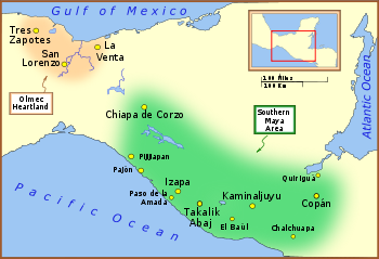
Quiriguá
Encyclopedia
Quiriguá is an ancient Maya
archaeological site
in the department
of Izabal in south-eastern Guatemala
. It is a medium-sized site covering approximately 3 square kilometres (1.2 sq mi) along the lower Motagua River
, with the ceremonial center about 1 km (0.621372736649807 mi) from the north bank. During the Maya Classic Period
(AD 200–900), Quiriguá was situated at the juncture of several important trade routes. The site was occupied by 200, construction on the acropolis
had begun by about 550, and an explosion of grander construction started in the 8th century. All construction had halted by about 850, except for a brief period of reoccupation in the Early Postclassic (c. 900 – c. 1200). Quiriguá shares its architectural and sculptural styles with the nearby Classic Period city of Copán
, with whose history it is closely entwined.
Quiriguá's rapid expansion in the 8th century was tied to king K'ak' Tiliw Chan Yopaat's military victory over Copán in 738. When the greatest king of Copán, Uaxaclajuun Ub'aah K'awiil
or "18-Rabbit", was defeated, he was captured and then sacrificed in the Great Plaza at Quiriguá. Before this, Quiriguá had been a vassal state
of Copán, but it maintained its independence afterwards. The ceremonial architecture
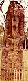
at Quiriguá is quite modest, but the site's importance lies in its wealth of sculpture, including the tallest stone monuments
ever erected in the New World
.
 The archaeological site of Quiriguá is named after the nearby village of the same name, and is located a little over 200 km (124.3 mi) northeast of Guatemala City
; it lies in the municipality of Los Amates
in the department of Izabal and has an elevation of 75 m (246.1 ft) above mean sea level
.
Positioned on the north bank of the lower reaches of the Motagua River
, Quiriguá is situated at the point where the valley broadens into a flood plain, which has exposed the site to periodic flooding over the centuries. Although the river passed close to the site during the period of the city's occupation, it has since changed course and now flows 1 km (0.621372736649807 mi) south of the ceremonial centre. Quiriguá is 48 km (29.8 mi) north of Copán, and is located 15.7 km (9.8 mi) north-west of the international border with Honduras
.
The local bedrock
is a hard red sandstone
, which the inhabitants used in the construction of monuments and architecture
. This local sandstone is very strong and not prone to shearing or fracturing, allowing the sculptors at Quiriguá to erect the tallest freestanding stone monuments in the Americas
. Quiriguá was built directly over the Motagua Fault
and the city suffered damage in ancient times as a result of major earthquake
s.
n area and the population was at least bi-ethnic, with ethnic Maya in a minority. The majority of the population belonged ethnically to the less complex Intermediate Area
lying beyond the eastern border of Mesoamerica. The population density
of the site has been estimated at 400 to 500 per square kilometer (1040 to 1300 per square mile) in the centre of the city during the Late Classic
with an estimated peak population of 1200–1600; surveys have revealed an average of 130 structures per square kilometer (338 per square mile) at the site, compared with 1449 structures/km2 (3767 per square mile) in central Copán. The low population density indicates that Quiriguá served as the focus for a dispersed rural population.
The population levels of the Quiriguá valley increased rapidly after the successful rebellion against Copán in 738, although it was never a heavily populated site. In the 9th century there was a severe decline in population, culminating in the abandonment of the city.
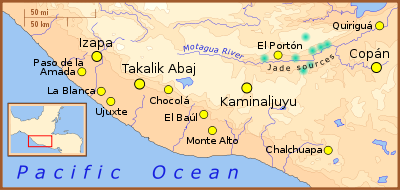
, and Quiriguá was ideally positioned to control the trade of uncut jade
, the majority of which was found in the middle reaches of the Motagua Valley, as well as controlling the flow of other important commodities up and down the river such as cacao, which was produced as a local cash crop
. Although cacao was produced for trade, maize remained the primary local crop due to its central role in the Maya diet. In addition, maize probably formed an important component in the site's tribute payments to its overlords at Copán, a city that was exhausting its own local resources. Although little jade has been recovered from the site, there is evidence for trade in obsidian
originating from the Ixtepeque
source situated near the upper reaches of the Motagua.
In the Classic Period, the location of the site would have placed Quiriguá on a crossroads between the trading route from the highlands to the Caribbean coast and the route from Copán to the major cities of the Petén Basin
.
{|class="wikitable"
! Name (or nickname)!!Ruled !!Dynastic
succession no.
|-
| "Tok Casper"
| 426–?
| 1
|-
| Tutuum Yohl K'inich
| c. 455
| ?
|-
| "Ruler 3" ("Turtle Shell")
| c. 480
Quiriguá (kiɾiˈɣwa) is an ancient Maya
archaeological site
in the department
of Izabal in south-eastern Guatemala
. It is a medium-sized site covering approximately 3 square kilometres (1.2 sq mi) along the lower Motagua River
, with the ceremonial center about 1 km (0.621372736649807 mi) from the north bank. During the Maya Classic Period
(AD 200–900), Quiriguá was situated at the juncture of several important trade routes. The site was occupied by 200, construction on the acropolis
had begun by about 550, and an explosion of grander construction started in the 8th century. All construction had halted by about 850, except for a brief period of reoccupation in the Early Postclassic (c. 900 – c. 1200). Quiriguá shares its architectural and sculptural styles with the nearby Classic Period city of Copán
, with whose history it is closely entwined.
Quiriguá's rapid expansion in the 8th century was tied to king K'ak' Tiliw Chan Yopaat's military victory over Copán in 738. When the greatest king of Copán, Uaxaclajuun Ub'aah K'awiil
or "18-Rabbit", was defeated, he was captured and then sacrificed in the Great Plaza at Quiriguá. Before this, Quiriguá had been a vassal state
of Copán, but it maintained its independence afterwards. The ceremonial architecture
at Quiriguá is quite modest, but the site's importance lies in its wealth of sculpture, including the tallest stone monuments
ever erected in the New World
.
The archaeological site of Quiriguá is named after the nearby village of the same name, and is located a little over 200 km (124.3 mi) northeast of Guatemala City
; it lies in the municipality of Los Amates
in the department of Izabal and has an elevation of 75 m (246.1 ft) above mean sea level
.
Positioned on the north bank of the lower reaches of the Motagua River
, Quiriguá is situated at the point where the valley broadens into a flood plain, which has exposed the site to periodic flooding over the centuries.Looper 2003, p.35. Although the river passed close to the site during the period of the city's occupation, it has since changed course and now flows 1 km (0.621372736649807 mi) south of the ceremonial centre. Quiriguá is 48 km (29.8 mi) north of Copán, and is located 15.7 km (9.8 mi) north-west of the international border with Honduras
.
The local bedrock
is a hard red sandstone
, which the inhabitants used in the construction of monuments and architecture
. This local sandstone is very strong and not prone to shearing or fracturing, allowing the sculptors at Quiriguá to erect the tallest freestanding stone monuments in the Americas
. Quiriguá was built directly over the Motagua Fault
and the city suffered damage in ancient times as a result of major earthquake
s.
n area and the population was at least bi-ethnic,Sheets 2000, p.442. with ethnic Maya in a minority. The majority of the population belonged ethnically to the less complex Intermediate Area
lying beyond the eastern border of Mesoamerica. The population density
of the site has been estimated at 400 to 500 per square kilometer (1040 to 1300 per square mile) in the centre of the city during the Late Classic
with an estimated peak population of 1200–1600; surveys have revealed an average of 130 structures per square kilometer (338 per square mile) at the site, compared with 1449 structures/km2 (3767 per square mile) in central Copán. The low population density indicates that Quiriguá served as the focus for a dispersed rural population.Looper 2003, p.1.
The population levels of the Quiriguá valley increased rapidly after the successful rebellion against Copán in 738, although it was never a heavily populated site. In the 9th century there was a severe decline in population, culminating in the abandonment of the city.
, and Quiriguá was ideally positioned to control the trade of uncut jade
, the majority of which was found in the middle reaches of the Motagua Valley,Miller 1999, p.54. as well as controlling the flow of other important commodities up and down the river such as cacao, which was produced as a local cash crop
.Drew 1999, p.240. Although cacao was produced for trade, maize remained the primary local crop due to its central role in the Maya diet.Ashmore 2007, p.111. In addition, maize probably formed an important component in the site's tribute payments to its overlords at Copán, a city that was exhausting its own local resources. Although little jade has been recovered from the site, there is evidence for trade in obsidian
originating from the Ixtepeque
source situated near the upper reaches of the Motagua.
In the Classic Period, the location of the site would have placed Quiriguá on a crossroads between the trading route from the highlands to the Caribbean coast and the route from Copán to the major cities of the Petén Basin
.Looper 2003, p.2.
{|class="wikitable"
! Name (or nickname)!!Ruled !!Dynastic
succession no.
|-
| "Tok Casper"
| 426–?Martin & Grube 2000, p.216.
| 1
|-
| Tutuum Yohl K'inich
| c. 455
| ?
|-
| "Ruler 3" ("Turtle Shell")
| c. 480Looper 2003, pp. 205–209.
| ?
|-
| "Ruler 4" ("Basket Skull")
| ?–?
| 3?
|-
| Mih Toh
| 493–
| 4?
|-
| K'awiil Yopaat ("Ruler 5")
| c. 653
| ?
|-
| K'ak' Tiliw Chan Yopaat ("Cauac Sky" or "Kawak Sky")
| 724–785Martin & Grube 2000, p.218.
| 14
|-
| "Sky Xul"
| 785 – c. 795
| 15
|-
| "Jade Sky"
| c. 800 – c. 810
| 17?
|}
 There is evidence that Quiriguá was occupied as early as the Late Preclassic
(400 BC – AD 200). Although no structures have been securely dated to this period, a number of Late Preclassic artifacts
have been recovered, including 63 figurine
s and a chert
blade. Early Classic ceramics
from Quiriguá are similar to finds at both Copán and Chalchuapa
in El Salvador
, while jade hunchback figurines from the same period resemble those found in central Honduras and in the Guatemalan highlands. These early finds demonstrate the participation of Quiriguá in the wider southeastern Maya region from the Late Preclassic onwards.Looper 2003, p.38.
A combination of hieroglyphic texts from Tikal
, Copán and Quiriguá, together with architectural styles and chemical tests of the bones of the founder of the Copán dynasty all suggest that Quiriguá and Copán were founded by elite colonists from the great city of Tikal
as a part of its expansion into the southeastern border area of the Maya region. The recorded history of Quiriguá starts in 426, in the Early Classic (c. 200 – c. 600); according to hieroglyphic inscriptions
at other sites, on 5 September of that year K'inich Yax K'uk' Mo'
was enthroned as king of Copán. Just three days later he installed "Tok Casper", the first known king of Quiriguá, upon the throne. From this it is evident that right from the beginning of its recorded history Quiriguá was subservient to its southern neighbour, and was founded to bring the lucrative trade route of the Motagua River under the control of Copán and, indirectly, of Tikal. During the next few centuries, about which little is known, the ceremonial architecture at Quiriguá was limited to the hilltop Group A and a broad earthen platform on the valley floor. It is recorded that a stela, as yet undiscovered, was erected in 455 by Tutuum Yohl K'inich, the second king of Quiriguá.Martin & Grube 2000, p.217. An early monument records the supervision of a ritual in 480 by the then overlord from Copán, demonstrating Quiriguá's continued status as a vassal of that city. A hieroglyphic text dating to 493 mentions two further kings of Quiriguá, but interruptions in the text make the reading and decipherment of their names particularly difficult.
There are close parallels between the 5th-century architecture and monuments of Quiriguá and Uaxactun
in the northern Petén, a site that fell under the domination of Tikal in the late 4th century. The similarities show that Quiriguá remained strongly aligned with the great Tikal alliance network.Looper 2003, p.50.
. There is evidence that Quiriguá suffered an attack by unknown enemies in this period, as demonstrated by the apparently deliberate defacement of Stela U and Monument 26, characteristic of damage inflicted by invading warriors. No monuments were erected during this hiatus, which lasted from 495 to 653.
In the 6th or early 7th century a natural disaster caused a devastating flood of the Motagua Valley and buried the surface of the site under a deep layer of silt
, completely changing the landscape. Only those buildings that stood above the mud continued in use, including group A, saved by its hilltop location. The earthen platform on the valley floor also continued in use, at least those parts of it that stood above the silt, and it was one of the site's smaller complexes that grew to become the new centre of Quiriguá, as represented by the monuments visible to this day.
A revival can be identified by the dedication of the first new monument in a century and a half, raised by the otherwise unknown king, K'awiil Yopaat, in 653. Continued contact with Copán is evident, as well as longer distance contacts, possibly with Caracol
in Belize
. At about the same time major construction work was undertaken in the acropolis
, including the building of the site's first ballcourt
.
, holy lord, instead of using the lesser term ahaw, subordinate lord; at the same time he began to use his own Quiriguá emblem glyph.Drew 1999, p.241. These early assertions of independence can only have been made if Quiriguá had managed to form an external alliance.
Indeed, this local act of rebellion appears to have been part of the larger political struggle between the two Maya "superpowers", the great cities of Tikal and Calakmul. In 736, only two years later, K'ak' Tiliw Chan Yopaat received a visit from Wamaw K'awiil, the high king of distant Calakmul, while Copán was one of Tikal's oldest allies. The timing of this visit by the king of Calakmul is highly significant, falling between the accession of K'ak' Tiliw Chan Yopaat to the throne of Quiriguá as a vassal of Copán and the outright rebellion that was to follow. This strongly suggests that Calakmul sponsored Quiriguá's rebellion in order to weaken Tikal and to gain access to the rich trade route of the Motagua Valley.Looper 2003, p.79. It is likely that contact with Calakmul had been initiated soon after K'ak' Tiliw Chan Yopaat acceded to the throne, since Quiriguá experienced rapid growth soon after, suggesting that Quiriguá already was receiving external support.
In 738 the interlinked fortunes of Quiriguá and Copán took a stunning change of direction when K'ak' Tiliw Chan Yopaat, reigning lord of Quiriguá, captured the powerful, but elderly 13th king of Copán, Uaxaclajuun Ub'aah K'awiil,Webster 2002, p.300. who had installed him on his throne in 725. This coup does not seem to have affected either Copán or Quiriguá physically, there is no evidence that either city was attacked at this time and the victor seems not to have received any detectable tribute.Drew 1999, p.286. Quiriguá seems rather to have gained its independence and the control of important trade routes. An inscription at Quiriguá, although difficult to interpret, suggests that the capture took place on 27 April 738, when Quiriguá seized and burned the wooden images of Copán's patron deities
. All of this seems to imply that K'ak' Tiliw Chan Yopaat managed to somehow ambush Uaxaclajuun Ub'aah K'awiil, rather than to have defeated him in outright battle. In the Classic Period the statues of Maya deities often were carried into battle on palanquins
, facilitating their capture in the event of defeat. It has been suggested that the king of Copán was attempting to attack another site in order to secure captives for sacrifice, and was ambushed by K'ak' Tiliw Chan Yopaat and his Quiriguá warriors.Looper 2003, p.78.
The captured lord was taken back to Quiriguá and on 3 May 738 he was decapitated in a public ritual. The sacrificial offering of the blood of such a powerful overlord greatly enhanced the standing of Quiriguá and its royal family throughout the region and it proclaimed Quiriguá as the new capital of the south-eastern Maya region.Looper 2003, p.76. After this, Quiriguá engaged in a major monument-building programme, closely mimicking the sculptural style of Copán, possibly using captured Copán sculptors to carry out the work.Miller 1999, pp.134–35. The population of Quiriguá and of other sites in the valley rapidly increased after the events of 738, although Quiriguá was always a small centre and its total population probably never exceeded 2,000.
In the Late Classic (c. 600 – c. 900), alliance with Calakmul frequently was associated with the promise of military support. The fact that Copán, a much more powerful city than Quiriguá, failed to retaliate against its former vassal implies that it feared the military intervention of Calakmul. Calakmul itself was far enough away from Quiriguá that K'ak' Tiliw Chan Yopaat was not afraid of falling directly under its power as a full vassal state, even though it is likely that Calakmul sent warriors to help in the defeat of Copán. The alliance instead seems to have been one of mutual advantage, Calakmul managed to weaken a powerful ally of Tikal while Quiriguá gained its independence.
In 718, the city of Xkuy – an as yet undiscovered site – was attacked and burned by Copán under the leadership of king Uaxaclajuun Ub'aah K'awiil. After the king of Copán was sacrificed in 738, Xkuy seems to have become a loyal vassal of Quiriguá and in 762 K'ak' Tiliw Chan Yopaat supervised the accession of "Sunraiser Jaguar" to the subservient city's throne.
K'ak' Tiliw Chan Yopaat, who had so dramatically changed the destiny of his city, died on 27 July 785. Zoomorph G is his memorial stone and it describes how he was buried 10 days later in the 13 Kawak House, a building that has not been identified. The great king was succeeded by "Sky Xul", a king whose name has not been properly identified. "Sky Xul" became the reigning lord of Quiriguá 78 days after the death of K'ak' Tiliw Chan Yopaat, who is thought to have been his father.Sharer & Traxler 2006, p.494 His reign lasted from 10 to 15 years and was a period of continued activity. In most of the Maya region cities already were suffering terminal decline, engulfed by the Classic Maya collapse
, but in Quiriguá "Sky Xul" dedicated three great zoomorph sculptures and two altar
s, considered marvels of Maya stoneworking. "Sky Xul" died some time between 795 and 800.
Quiriguá apparently retained its independence from Copán and continued to flourish until the beginning of the 9th century. Relations between the two cities had improved somewhat by 810, when king Yax Pasaj Chan Yopaat
of Copán visited Quiriguá in order to carry out a k'atun
-ending ritual. However, 810 was also the year when the last hieroglyphic texts were raised at Quiriguá, although a reduced level of construction continued in the city centre. After this, Quiriguá falls into silence, engulfed by the greater phenomenon of the Classic Maya collapse
– it had lost its reason for existence when trade no longer flowed along the Motagua; within a few years Quiriguá was all but deserted and sites throughout the Motagua Valley suffered severe decline or abandonment.Martin & Grube 2000, p.225.
and Belize
, perhaps due to Chontal Maya control of a trade network that included the Yucatán coast and the Motagua Valley. During their brief reoccupation of the site they made substantial additions to the acropolis complex. Finds associated with their occupation include a reclining chacmool sculpture and ceramics from the east coast of Yucatán, artifacts that demonstrate a close link with the distant city of Chichen Itza
. Some copper
bells and ornaments were recovered from Quiriguá, they are among the earliest finds of metal artifacts
in the Maya area. They have been dated to either the Terminal Classic (c. 800 – c. 950) or the Early Postclassic.
, who reached the ruins in 1840. The previous landowner, by the surname of Payés, had related the existence of the ruins to his sons and to Carlos Meiney, a Jamaica
n Englishman resident in Guatemala. The elder Payés had recently died and passed the land to his sons and, since neither Meiney nor Payés' sons had visited the land containing the ruins, they invited John Lloyd Stephens
and Catherwood to join them on their first trip to the site. Stephens had other duties to attend to, but Catherwood was able to accompany the Payés brothers to Quiriguá.Kelly 1996, p.243. Due to adverse conditions he was only able to stay a short time at the ruins, but made drawings of two of the stelae, which were published with a short account of Catherwood's visit in John Lloyd Stephens's book Incidents of Travel in Central America, Chiapas, and Yucatan in 1841. Quiriguá was the first site that Stephens and Catherwood could claim to have discovered themselves. A longer account of the ruins was made in 1854 by Dr. Karl Scherzer.
Explorer and archaeologist Alfred Maudslay
visited Quiriguá for three days in 1881; they were the first pre-Columbian
ruins that he saw and they were sufficiently impressive to inspire him to take up a permanent interest in Central American archaeology. He was able to return on three further occasions, the last being in 1894, and he made the first efforts to clear the monuments before recording them. He carried out a very thorough examination and made a photographic record of all visible monuments, carried out some minor excavations, made paper and plaster molds
of the hieroglyphic inscriptions and surveyed the principal sculptures; these molds were then shipped to the Victoria and Albert Museum
, with casts being transferred to the British Museum
.
In 1910, the United Fruit Company
bought Quiriguá and all the land for a great distance around the site for banana
production; they set aside 75 acres (30.4 ha) around the ceremonial centre as an archaeological park, leaving an island of jungle among the plantations.Kelly 1996, p.244. More archaeological work was carried out from 1910 to 1914 by Edgar Lee Hewett
and Sylvanus Morley
for the School of American Archaeology in Santa Fe. Duplicates of the stelae of Quiriguá made from Hewitt's plaster casts of the originals were exhibited at the Panama-California Exposition
in San Diego, California
, in 1915. The casts are still on display at the San Diego Museum of Man
in their "Maya: Heart of Sky, Heart of Earth" exhibition. The Carnegie Institution conducted several intermittent projects at Quiriguá from 1915 through 1934. Aldous Huxley
, writing after visiting the site in the early 1930s, noted that Quiriguá's stelae commemorated "man's triumph over time and matter and the triumph of time and matter over man." Quiriguá was among the first Maya archaeological sites to be studied intensively, although little restoration was carried out and the ruins once again became overgrown with jungle.
Quiriguá was declared a National Monument in 1970 under Ministerial Accord 1210, this was followed on 19 June 1974 by its declaration as an Archaeological Park under Governmental Accord 35-74.Torres.
From 1974 through 1979, an extensive archaeological project was conducted at Quiriguá sponsored by the University of Pennsylvania
, the National Geographic Society
, and the Guatemalan Instituto de Antropología e Historia
. Directed by Robert Sharer
and William R. Coe
, the project excavated the acropolis, cleaned the monuments, and studied outlying groups.Sharer & Traxler 2006, p.352.Martin & Grube 2000, p.215. It was declared a UNESCO
World Heritage Site
in 1981, and in 1999 UNESCO approved one-off funding of US$27,248 for "emergency assistance for the rehabilitation of the archaeological site of Quiriguá". One of the site's stelae is depicted on the Guatemalan 10 centavo coin.
The 34 hectares (84 acre) area included within the Archaeological Park of Quiriguá has been developed for tourism with the construction of a car park, site museum, and sanitation facilities and is open to the public on a daily basis.
, palace, and ballcourt all lie at the southern end of the Great Plaza. The ceremonial centre is laid out around three plazas, the northernmost is the Great Plaza. This plaza measures 325 m (1,066.3 ft) from north to south and is the largest plaza in the whole Maya region. At the southern end of the Great Plaza is the Ballcourt Plaza, surrounded on three sides by structures associated with the acropolis. The Acropolis Plaza is a fully enclosed plaza within the acropolis itself. The area to the west of the Ballcourt Plaza was probably the riverside docking area and there is evidence that the southern part of the Great Plaza was a marketplace. A number of ceramic-lined wells
have been excavated close to the site core, these were all built in the 8th century and although some continued in use into the 9th century, none are known to have been built that late.
Groups A, B and C lie at a distance of one to three miles from the site core.
elaborately carved from single blocks of red sandstone, brought from quarries 5 kilometres (3 mi) away. The characteristics of this hard rock allowed the local sculptors to produce low-relief
sculptures enhanced by three-dimensional faces, in contrast with the contemporary two-dimensional sculpture of the Petén
region. After the defeat and execution of the king of Copán in 738, the sculptural style of Quiriguá closely resembled that of its former overlord. The enormous stelae at Quirigá originally would have been visible from the Motagua River, which once flowed past the west side of the Great Plaza, announcing the new-found power of the city to passing traders.Sharer & Traxler 2006, p.486. The monuments include long panels of glyphic text that are considered among the most complex and beautiful of all Maya stone inscriptions. A characteristic of these texts is the use of full-figure glyphs in which the normal bar and dot number glyphs of Maya script
are replaced with exquisitely carved representations of the deities.Drew 1999, p.242. However, by the latter part of the 8th century Quiriguá had developed an original style with the production of boulders elaborately sculpted into the forms of composite mythological animals
bearing elements of toad
s, jaguar
s, crocodile
s, and birds of prey; these sculptures are referred to as zoomorphs and were completed by two later kings after the death of K'ak' Tiliw Chan Yopaat in 785.
There also are various altars and sculptures used as decoration in the facades of buildings; most Quiriguá monuments have a grand formal monumentality that is rather stiff compared to the naturalistic grace of the art of some other Maya sites. Traces of red pigment
have been found on some of the monuments and most of the monuments were likely to have been painted red, the colour of birth, sacrifice, and renewal.Looper 2003, p.17.
Maya civilization
The Maya is a Mesoamerican civilization, noted for the only known fully developed written language of the pre-Columbian Americas, as well as for its art, architecture, and mathematical and astronomical systems. Initially established during the Pre-Classic period The Maya is a Mesoamerican...
archaeological site
Archaeological site
An archaeological site is a place in which evidence of past activity is preserved , and which has been, or may be, investigated using the discipline of archaeology and represents a part of the archaeological record.Beyond this, the definition and geographical extent of a 'site' can vary widely,...
in the department
Departments of Guatemala
||Guatemala is divided into 22 departments :#Alta Verapaz#Baja Verapaz#Chimaltenango#Chiquimula#Petén#El Progreso#El Quiché#Escuintla#Guatemala#Huehuetenango#Izabal#Jalapa#Jutiapa#Quetzaltenango#Retalhuleu#Sacatepéquez...
of Izabal in south-eastern Guatemala
Guatemala
Guatemala is a country in Central America bordered by Mexico to the north and west, the Pacific Ocean to the southwest, Belize to the northeast, the Caribbean to the east, and Honduras and El Salvador to the southeast...
. It is a medium-sized site covering approximately 3 square kilometres (1.2 sq mi) along the lower Motagua River
Motagua River
The Motagua River is a long river in Guatemala. It rises in the western highlands of Guatemala where it is also called Río Grande, and runs in an easterly direction to the Gulf of Honduras. The final few kilometres of the river form part of the Guatemala/Honduras border...
, with the ceremonial center about 1 km (0.621372736649807 mi) from the north bank. During the Maya Classic Period
Mesoamerican chronology
Mesoamerican chronology divides the history of pre-Columbian Mesoamerica into several periods: the Paleo-Indian , the Archaic , the Preclassic , the Classic , and the Postclassic...
(AD 200–900), Quiriguá was situated at the juncture of several important trade routes. The site was occupied by 200, construction on the acropolis
Acropolis
Acropolis means "high city" in Greek, literally city on the extremity and is usually translated into English as Citadel . For purposes of defense, early people naturally chose elevated ground to build a new settlement, frequently a hill with precipitous sides...
had begun by about 550, and an explosion of grander construction started in the 8th century. All construction had halted by about 850, except for a brief period of reoccupation in the Early Postclassic (c. 900 – c. 1200). Quiriguá shares its architectural and sculptural styles with the nearby Classic Period city of Copán
Copán
Copán is an archaeological site of the Maya civilization located in the Copán Department of western Honduras, not far from the border with Guatemala. It was the capital city of a major Classic period kingdom from the 5th to 9th centuries AD...
, with whose history it is closely entwined.
Quiriguá's rapid expansion in the 8th century was tied to king K'ak' Tiliw Chan Yopaat's military victory over Copán in 738. When the greatest king of Copán, Uaxaclajuun Ub'aah K'awiil
Uaxaclajuun Ub'aah K'awiil
Uaxaclajuun Ub'aah K'awiil , was a ruler of the powerful Maya polity associated with the site of Copán in modern Honduras . He ruled from January 2, 695, to May 3, 738...
or "18-Rabbit", was defeated, he was captured and then sacrificed in the Great Plaza at Quiriguá. Before this, Quiriguá had been a vassal state
Vassal state
A vassal state is any state that is subordinate to another. The vassal in these cases is the ruler, rather than the state itself. Being a vassal most commonly implies providing military assistance to the dominant state when requested to do so; it sometimes implies paying tribute, but a state which...
of Copán, but it maintained its independence afterwards. The ceremonial architecture
Maya architecture
A unique and spectacular style, Maya architecture spans several thousands of years. Often the most dramatic and easily recognizable as Maya are the stepped pyramids from the Terminal Pre-classic period and beyond. Being based on the general Mesoamerican architectural traditions these pyramids...
at Quiriguá is quite modest, but the site's importance lies in its wealth of sculpture, including the tallest stone monuments
Monumental sculpture
The term monumental sculpture is often used in art history and criticism, but not always consistently. It combines two concepts, one of function, and one of size, and may include an element of a third more subjective concept. It is often used for all sculptures that are large...
ever erected in the New World
New World
The New World is one of the names used for the Western Hemisphere, specifically America and sometimes Oceania . The term originated in the late 15th century, when America had been recently discovered by European explorers, expanding the geographical horizon of the people of the European middle...
.
Name and location
Guatemala City
Guatemala City , is the capital and largest city of the Republic of Guatemala and Central America...
; it lies in the municipality of Los Amates
Los Amates
Los Amates is a municipality in the Izabal department of Guatemala. Their population is about 56,000. Their mayor is currently Marco Tulio Ramirez Estrada.Los Amates is located on the Motagua River, from the ruins of the ancient Maya city of Quiriguá....
in the department of Izabal and has an elevation of 75 m (246.1 ft) above mean sea level
Above mean sea level
The term above mean sea level refers to the elevation or altitude of any object, relative to the average sea level datum. AMSL is used extensively in radio by engineers to determine the coverage area a station will be able to reach...
.
Positioned on the north bank of the lower reaches of the Motagua River
Motagua River
The Motagua River is a long river in Guatemala. It rises in the western highlands of Guatemala where it is also called Río Grande, and runs in an easterly direction to the Gulf of Honduras. The final few kilometres of the river form part of the Guatemala/Honduras border...
, Quiriguá is situated at the point where the valley broadens into a flood plain, which has exposed the site to periodic flooding over the centuries. Although the river passed close to the site during the period of the city's occupation, it has since changed course and now flows 1 km (0.621372736649807 mi) south of the ceremonial centre. Quiriguá is 48 km (29.8 mi) north of Copán, and is located 15.7 km (9.8 mi) north-west of the international border with Honduras
Honduras
Honduras is a republic in Central America. It was previously known as Spanish Honduras to differentiate it from British Honduras, which became the modern-day state of Belize...
.
The local bedrock
Bedrock
In stratigraphy, bedrock is the native consolidated rock underlying the surface of a terrestrial planet, usually the Earth. Above the bedrock is usually an area of broken and weathered unconsolidated rock in the basal subsoil...
is a hard red sandstone
Sandstone
Sandstone is a sedimentary rock composed mainly of sand-sized minerals or rock grains.Most sandstone is composed of quartz and/or feldspar because these are the most common minerals in the Earth's crust. Like sand, sandstone may be any colour, but the most common colours are tan, brown, yellow,...
, which the inhabitants used in the construction of monuments and architecture
Mesoamerican architecture
Mesoamerican architecture is the set of architectural traditions produced by pre-Columbian cultures and civilizations of Mesoamerica, traditions which are best known in the form of public, ceremonial and urban monumental buildings and structures...
. This local sandstone is very strong and not prone to shearing or fracturing, allowing the sculptors at Quiriguá to erect the tallest freestanding stone monuments in the Americas
Americas
The Americas, or America , are lands in the Western hemisphere, also known as the New World. In English, the plural form the Americas is often used to refer to the landmasses of North America and South America with their associated islands and regions, while the singular form America is primarily...
. Quiriguá was built directly over the Motagua Fault
Motagua Fault
The Motagua Fault is a major, active left lateral-moving transform fault which cuts across Guatemala. It forms part of the tectonic boundary between the North American Plate and the Caribbean Plate...
and the city suffered damage in ancient times as a result of major earthquake
Earthquake
An earthquake is the result of a sudden release of energy in the Earth's crust that creates seismic waves. The seismicity, seismism or seismic activity of an area refers to the frequency, type and size of earthquakes experienced over a period of time...
s.
Population
Although the Quiriguá elite were clearly Maya in ethnicity, the site lies on the southern periphery of the MesoamericaMesoamerica
Mesoamerica is a region and culture area in the Americas, extending approximately from central Mexico to Belize, Guatemala, El Salvador, Honduras, Nicaragua, and Costa Rica, within which a number of pre-Columbian societies flourished before the Spanish colonization of the Americas in the 15th and...
n area and the population was at least bi-ethnic, with ethnic Maya in a minority. The majority of the population belonged ethnically to the less complex Intermediate Area
Intermediate Area
The Intermediate Area is an archaeological geographical area of the Americas that was defined in its clearest form by Gordon R. Willey in his 1971 book An Introduction to American Archaeology, Vol. 2: South America...
lying beyond the eastern border of Mesoamerica. The population density
Population density
Population density is a measurement of population per unit area or unit volume. It is frequently applied to living organisms, and particularly to humans...
of the site has been estimated at 400 to 500 per square kilometer (1040 to 1300 per square mile) in the centre of the city during the Late Classic
Mesoamerican chronology
Mesoamerican chronology divides the history of pre-Columbian Mesoamerica into several periods: the Paleo-Indian , the Archaic , the Preclassic , the Classic , and the Postclassic...
with an estimated peak population of 1200–1600; surveys have revealed an average of 130 structures per square kilometer (338 per square mile) at the site, compared with 1449 structures/km2 (3767 per square mile) in central Copán. The low population density indicates that Quiriguá served as the focus for a dispersed rural population.
The population levels of the Quiriguá valley increased rapidly after the successful rebellion against Copán in 738, although it was never a heavily populated site. In the 9th century there was a severe decline in population, culminating in the abandonment of the city.
Economy
The Motagua River flows down from the western Guatemalan highlandsGuatemalan Highlands
The Guatemalan Highlands is an upland region in southern Guatemala, lying between the Sierra Madre de Chiapas to the south and the Petén lowlands to the north....
, and Quiriguá was ideally positioned to control the trade of uncut jade
Jade
Jade is an ornamental stone.The term jade is applied to two different metamorphic rocks that are made up of different silicate minerals:...
, the majority of which was found in the middle reaches of the Motagua Valley, as well as controlling the flow of other important commodities up and down the river such as cacao, which was produced as a local cash crop
Cash crop
In agriculture, a cash crop is a crop which is grown for profit.The term is used to differentiate from subsistence crops, which are those fed to the producer's own livestock or grown as food for the producer's family...
. Although cacao was produced for trade, maize remained the primary local crop due to its central role in the Maya diet. In addition, maize probably formed an important component in the site's tribute payments to its overlords at Copán, a city that was exhausting its own local resources. Although little jade has been recovered from the site, there is evidence for trade in obsidian
Obsidian use in Mesoamerica
Obsidian is a naturally formed volcanic glass that was an important part of the material culture of Pre-Columbian Mesoamerica. Obsidian was a highly integrated part of daily and ritual life, and its widespread and varied use may be a significant contributor to Mesoamerica's lack of metallurgy...
originating from the Ixtepeque
Ixtepeque
Volcán Ixtepeque is a stratovolcano in southern Guatemala. It consists of several rhyolitic lava domes and basaltic cinder cones.Its name is derived from the nahuatl word for obsidian. Ixtepeque was one of the most important obsidian sources in pre-Columbian Mesoamerica....
source situated near the upper reaches of the Motagua.
In the Classic Period, the location of the site would have placed Quiriguá on a crossroads between the trading route from the highlands to the Caribbean coast and the route from Copán to the major cities of the Petén Basin
Petén Basin
The Petén Basin is a geographical subregion of Mesoamerica, located in the northern portion of the modern-day nation of Guatemala, and essentially contained within the department of El Petén...
.
Known rulers
As recorded on hieroglyphic inscriptions at Quiriguá, all dates are AD. Maya inscriptions for rulers sometimes include reference to a number ("hel-number" or count, named after its main glyph) that are believed to specify the position of that ruler in the sequence of dynastic succession to the rulership of the site. Thus a hel-number of five indicates the ruler was fifth in the line of dynastic succession.{|class="wikitable"
! Name (or nickname)!!Ruled !!Dynastic
succession no.
|-
| "Tok Casper"
| 426–?
| 1
|-
| Tutuum Yohl K'inich
| c. 455
| ?
|-
| "Ruler 3" ("Turtle Shell")
| c. 480
Quiriguá (kiɾiˈɣwa) is an ancient Maya
Maya civilization
The Maya is a Mesoamerican civilization, noted for the only known fully developed written language of the pre-Columbian Americas, as well as for its art, architecture, and mathematical and astronomical systems. Initially established during the Pre-Classic period The Maya is a Mesoamerican...
archaeological site
Archaeological site
An archaeological site is a place in which evidence of past activity is preserved , and which has been, or may be, investigated using the discipline of archaeology and represents a part of the archaeological record.Beyond this, the definition and geographical extent of a 'site' can vary widely,...
in the department
Departments of Guatemala
||Guatemala is divided into 22 departments :#Alta Verapaz#Baja Verapaz#Chimaltenango#Chiquimula#Petén#El Progreso#El Quiché#Escuintla#Guatemala#Huehuetenango#Izabal#Jalapa#Jutiapa#Quetzaltenango#Retalhuleu#Sacatepéquez...
of Izabal in south-eastern Guatemala
Guatemala
Guatemala is a country in Central America bordered by Mexico to the north and west, the Pacific Ocean to the southwest, Belize to the northeast, the Caribbean to the east, and Honduras and El Salvador to the southeast...
. It is a medium-sized site covering approximately 3 square kilometres (1.2 sq mi) along the lower Motagua River
Motagua River
The Motagua River is a long river in Guatemala. It rises in the western highlands of Guatemala where it is also called Río Grande, and runs in an easterly direction to the Gulf of Honduras. The final few kilometres of the river form part of the Guatemala/Honduras border...
, with the ceremonial center about 1 km (0.621372736649807 mi) from the north bank. During the Maya Classic Period
Mesoamerican chronology
Mesoamerican chronology divides the history of pre-Columbian Mesoamerica into several periods: the Paleo-Indian , the Archaic , the Preclassic , the Classic , and the Postclassic...
(AD 200–900), Quiriguá was situated at the juncture of several important trade routes. The site was occupied by 200, construction on the acropolis
Acropolis
Acropolis means "high city" in Greek, literally city on the extremity and is usually translated into English as Citadel . For purposes of defense, early people naturally chose elevated ground to build a new settlement, frequently a hill with precipitous sides...
had begun by about 550, and an explosion of grander construction started in the 8th century. All construction had halted by about 850, except for a brief period of reoccupation in the Early Postclassic (c. 900 – c. 1200). Quiriguá shares its architectural and sculptural styles with the nearby Classic Period city of Copán
Copán
Copán is an archaeological site of the Maya civilization located in the Copán Department of western Honduras, not far from the border with Guatemala. It was the capital city of a major Classic period kingdom from the 5th to 9th centuries AD...
, with whose history it is closely entwined.
Quiriguá's rapid expansion in the 8th century was tied to king K'ak' Tiliw Chan Yopaat's military victory over Copán in 738. When the greatest king of Copán, Uaxaclajuun Ub'aah K'awiil
Uaxaclajuun Ub'aah K'awiil
Uaxaclajuun Ub'aah K'awiil , was a ruler of the powerful Maya polity associated with the site of Copán in modern Honduras . He ruled from January 2, 695, to May 3, 738...
or "18-Rabbit", was defeated, he was captured and then sacrificed in the Great Plaza at Quiriguá. Before this, Quiriguá had been a vassal state
Vassal state
A vassal state is any state that is subordinate to another. The vassal in these cases is the ruler, rather than the state itself. Being a vassal most commonly implies providing military assistance to the dominant state when requested to do so; it sometimes implies paying tribute, but a state which...
of Copán, but it maintained its independence afterwards. The ceremonial architecture
Maya architecture
A unique and spectacular style, Maya architecture spans several thousands of years. Often the most dramatic and easily recognizable as Maya are the stepped pyramids from the Terminal Pre-classic period and beyond. Being based on the general Mesoamerican architectural traditions these pyramids...
at Quiriguá is quite modest, but the site's importance lies in its wealth of sculpture, including the tallest stone monuments
Monumental sculpture
The term monumental sculpture is often used in art history and criticism, but not always consistently. It combines two concepts, one of function, and one of size, and may include an element of a third more subjective concept. It is often used for all sculptures that are large...
ever erected in the New World
New World
The New World is one of the names used for the Western Hemisphere, specifically America and sometimes Oceania . The term originated in the late 15th century, when America had been recently discovered by European explorers, expanding the geographical horizon of the people of the European middle...
.
Name and location
Guatemala City
Guatemala City , is the capital and largest city of the Republic of Guatemala and Central America...
; it lies in the municipality of Los Amates
Los Amates
Los Amates is a municipality in the Izabal department of Guatemala. Their population is about 56,000. Their mayor is currently Marco Tulio Ramirez Estrada.Los Amates is located on the Motagua River, from the ruins of the ancient Maya city of Quiriguá....
in the department of Izabal and has an elevation of 75 m (246.1 ft) above mean sea level
Above mean sea level
The term above mean sea level refers to the elevation or altitude of any object, relative to the average sea level datum. AMSL is used extensively in radio by engineers to determine the coverage area a station will be able to reach...
.
Positioned on the north bank of the lower reaches of the Motagua River
Motagua River
The Motagua River is a long river in Guatemala. It rises in the western highlands of Guatemala where it is also called Río Grande, and runs in an easterly direction to the Gulf of Honduras. The final few kilometres of the river form part of the Guatemala/Honduras border...
, Quiriguá is situated at the point where the valley broadens into a flood plain, which has exposed the site to periodic flooding over the centuries.Looper 2003, p.35. Although the river passed close to the site during the period of the city's occupation, it has since changed course and now flows 1 km (0.621372736649807 mi) south of the ceremonial centre. Quiriguá is 48 km (29.8 mi) north of Copán, and is located 15.7 km (9.8 mi) north-west of the international border with Honduras
Honduras
Honduras is a republic in Central America. It was previously known as Spanish Honduras to differentiate it from British Honduras, which became the modern-day state of Belize...
.
The local bedrock
Bedrock
In stratigraphy, bedrock is the native consolidated rock underlying the surface of a terrestrial planet, usually the Earth. Above the bedrock is usually an area of broken and weathered unconsolidated rock in the basal subsoil...
is a hard red sandstone
Sandstone
Sandstone is a sedimentary rock composed mainly of sand-sized minerals or rock grains.Most sandstone is composed of quartz and/or feldspar because these are the most common minerals in the Earth's crust. Like sand, sandstone may be any colour, but the most common colours are tan, brown, yellow,...
, which the inhabitants used in the construction of monuments and architecture
Mesoamerican architecture
Mesoamerican architecture is the set of architectural traditions produced by pre-Columbian cultures and civilizations of Mesoamerica, traditions which are best known in the form of public, ceremonial and urban monumental buildings and structures...
. This local sandstone is very strong and not prone to shearing or fracturing, allowing the sculptors at Quiriguá to erect the tallest freestanding stone monuments in the Americas
Americas
The Americas, or America , are lands in the Western hemisphere, also known as the New World. In English, the plural form the Americas is often used to refer to the landmasses of North America and South America with their associated islands and regions, while the singular form America is primarily...
. Quiriguá was built directly over the Motagua Fault
Motagua Fault
The Motagua Fault is a major, active left lateral-moving transform fault which cuts across Guatemala. It forms part of the tectonic boundary between the North American Plate and the Caribbean Plate...
and the city suffered damage in ancient times as a result of major earthquake
Earthquake
An earthquake is the result of a sudden release of energy in the Earth's crust that creates seismic waves. The seismicity, seismism or seismic activity of an area refers to the frequency, type and size of earthquakes experienced over a period of time...
s.
Population
Although the Quiriguá elite were clearly Maya in ethnicity, the site lies on the southern periphery of the MesoamericaMesoamerica
Mesoamerica is a region and culture area in the Americas, extending approximately from central Mexico to Belize, Guatemala, El Salvador, Honduras, Nicaragua, and Costa Rica, within which a number of pre-Columbian societies flourished before the Spanish colonization of the Americas in the 15th and...
n area and the population was at least bi-ethnic,Sheets 2000, p.442. with ethnic Maya in a minority. The majority of the population belonged ethnically to the less complex Intermediate Area
Intermediate Area
The Intermediate Area is an archaeological geographical area of the Americas that was defined in its clearest form by Gordon R. Willey in his 1971 book An Introduction to American Archaeology, Vol. 2: South America...
lying beyond the eastern border of Mesoamerica. The population density
Population density
Population density is a measurement of population per unit area or unit volume. It is frequently applied to living organisms, and particularly to humans...
of the site has been estimated at 400 to 500 per square kilometer (1040 to 1300 per square mile) in the centre of the city during the Late Classic
Mesoamerican chronology
Mesoamerican chronology divides the history of pre-Columbian Mesoamerica into several periods: the Paleo-Indian , the Archaic , the Preclassic , the Classic , and the Postclassic...
with an estimated peak population of 1200–1600; surveys have revealed an average of 130 structures per square kilometer (338 per square mile) at the site, compared with 1449 structures/km2 (3767 per square mile) in central Copán. The low population density indicates that Quiriguá served as the focus for a dispersed rural population.Looper 2003, p.1.
The population levels of the Quiriguá valley increased rapidly after the successful rebellion against Copán in 738, although it was never a heavily populated site. In the 9th century there was a severe decline in population, culminating in the abandonment of the city.
Economy
The Motagua River flows down from the western Guatemalan highlandsGuatemalan Highlands
The Guatemalan Highlands is an upland region in southern Guatemala, lying between the Sierra Madre de Chiapas to the south and the Petén lowlands to the north....
, and Quiriguá was ideally positioned to control the trade of uncut jade
Jade
Jade is an ornamental stone.The term jade is applied to two different metamorphic rocks that are made up of different silicate minerals:...
, the majority of which was found in the middle reaches of the Motagua Valley,Miller 1999, p.54. as well as controlling the flow of other important commodities up and down the river such as cacao, which was produced as a local cash crop
Cash crop
In agriculture, a cash crop is a crop which is grown for profit.The term is used to differentiate from subsistence crops, which are those fed to the producer's own livestock or grown as food for the producer's family...
.Drew 1999, p.240. Although cacao was produced for trade, maize remained the primary local crop due to its central role in the Maya diet.Ashmore 2007, p.111. In addition, maize probably formed an important component in the site's tribute payments to its overlords at Copán, a city that was exhausting its own local resources. Although little jade has been recovered from the site, there is evidence for trade in obsidian
Obsidian use in Mesoamerica
Obsidian is a naturally formed volcanic glass that was an important part of the material culture of Pre-Columbian Mesoamerica. Obsidian was a highly integrated part of daily and ritual life, and its widespread and varied use may be a significant contributor to Mesoamerica's lack of metallurgy...
originating from the Ixtepeque
Ixtepeque
Volcán Ixtepeque is a stratovolcano in southern Guatemala. It consists of several rhyolitic lava domes and basaltic cinder cones.Its name is derived from the nahuatl word for obsidian. Ixtepeque was one of the most important obsidian sources in pre-Columbian Mesoamerica....
source situated near the upper reaches of the Motagua.
In the Classic Period, the location of the site would have placed Quiriguá on a crossroads between the trading route from the highlands to the Caribbean coast and the route from Copán to the major cities of the Petén Basin
Petén Basin
The Petén Basin is a geographical subregion of Mesoamerica, located in the northern portion of the modern-day nation of Guatemala, and essentially contained within the department of El Petén...
.Looper 2003, p.2.
Known rulers
As recorded on hieroglyphic inscriptions at Quiriguá, all dates are AD. Maya inscriptions for rulers sometimes include reference to a number ("hel-number" or count, named after its main glyph) that are believed to specify the position of that ruler in the sequence of dynastic succession to the rulership of the site. Thus a hel-number of five indicates the ruler was fifth in the line of dynastic succession.{|class="wikitable"
! Name (or nickname)!!Ruled !!Dynastic
succession no.
|-
| "Tok Casper"
| 426–?Martin & Grube 2000, p.216.
| 1
|-
| Tutuum Yohl K'inich
| c. 455
| ?
|-
| "Ruler 3" ("Turtle Shell")
| c. 480Looper 2003, pp. 205–209.
| ?
|-
| "Ruler 4" ("Basket Skull")
| ?–?
| 3?
|-
| Mih Toh
| 493–
| 4?
|-
| K'awiil Yopaat ("Ruler 5")
| c. 653
| ?
|-
| K'ak' Tiliw Chan Yopaat ("Cauac Sky" or "Kawak Sky")
| 724–785Martin & Grube 2000, p.218.
| 14
|-
| "Sky Xul"
| 785 – c. 795
| 15
|-
| "Jade Sky"
| c. 800 – c. 810
| 17?
|}
Early history
Mesoamerican chronology
Mesoamerican chronology divides the history of pre-Columbian Mesoamerica into several periods: the Paleo-Indian , the Archaic , the Preclassic , the Classic , and the Postclassic...
(400 BC – AD 200). Although no structures have been securely dated to this period, a number of Late Preclassic artifacts
Artifact (archaeology)
An artifact or artefact is "something made or given shape by man, such as a tool or a work of art, esp an object of archaeological interest"...
have been recovered, including 63 figurine
Figurine
A figurine is a statuette that represents a human, deity or animal. Figurines may be realistic or iconic, depending on the skill and intention of the creator. The earliest were made of stone or clay...
s and a chert
Chert
Chert is a fine-grained silica-rich microcrystalline, cryptocrystalline or microfibrous sedimentary rock that may contain small fossils. It varies greatly in color , but most often manifests as gray, brown, grayish brown and light green to rusty red; its color is an expression of trace elements...
blade. Early Classic ceramics
Ceramic art
In art history, ceramics and ceramic art mean art objects such as figures, tiles, and tableware made from clay and other raw materials by the process of pottery. Some ceramic products are regarded as fine art, while others are regarded as decorative, industrial or applied art objects, or as...
from Quiriguá are similar to finds at both Copán and Chalchuapa
Chalchuapa
Chalchuapa is a town and a municipality located in the Santa Ana department of El Salvador. The city of Chalchuapa is in a wide valley at 650 meters above sea level, and watered by the Pampe River.- Overview :...
in El Salvador
El Salvador
El Salvador or simply Salvador is the smallest and the most densely populated country in Central America. The country's capital city and largest city is San Salvador; Santa Ana and San Miguel are also important cultural and commercial centers in the country and in all of Central America...
, while jade hunchback figurines from the same period resemble those found in central Honduras and in the Guatemalan highlands. These early finds demonstrate the participation of Quiriguá in the wider southeastern Maya region from the Late Preclassic onwards.Looper 2003, p.38.
A combination of hieroglyphic texts from Tikal
Tikal
Tikal is one of the largest archaeological sites and urban centres of the pre-Columbian Maya civilization. It is located in the archaeological region of the Petén Basin in what is now northern Guatemala...
, Copán and Quiriguá, together with architectural styles and chemical tests of the bones of the founder of the Copán dynasty all suggest that Quiriguá and Copán were founded by elite colonists from the great city of Tikal
Tikal
Tikal is one of the largest archaeological sites and urban centres of the pre-Columbian Maya civilization. It is located in the archaeological region of the Petén Basin in what is now northern Guatemala...
as a part of its expansion into the southeastern border area of the Maya region. The recorded history of Quiriguá starts in 426, in the Early Classic (c. 200 – c. 600); according to hieroglyphic inscriptions
Maya script
The Maya script, also known as Maya glyphs or Maya hieroglyphs, is the writing system of the pre-Columbian Maya civilization of Mesoamerica, presently the only Mesoamerican writing system that has been substantially deciphered...
at other sites, on 5 September of that year K'inich Yax K'uk' Mo'
K'inich Yax K'uk' Mo'
K'inich Yax K'uk' Mo is named in Maya inscriptions as the founder and first ruler of the pre-Columbian Maya civilization polity centered at Copán, a major Maya site located in the southeastern Maya lowlands region in present-day Honduras...
was enthroned as king of Copán. Just three days later he installed "Tok Casper", the first known king of Quiriguá, upon the throne. From this it is evident that right from the beginning of its recorded history Quiriguá was subservient to its southern neighbour, and was founded to bring the lucrative trade route of the Motagua River under the control of Copán and, indirectly, of Tikal. During the next few centuries, about which little is known, the ceremonial architecture at Quiriguá was limited to the hilltop Group A and a broad earthen platform on the valley floor. It is recorded that a stela, as yet undiscovered, was erected in 455 by Tutuum Yohl K'inich, the second king of Quiriguá.Martin & Grube 2000, p.217. An early monument records the supervision of a ritual in 480 by the then overlord from Copán, demonstrating Quiriguá's continued status as a vassal of that city. A hieroglyphic text dating to 493 mentions two further kings of Quiriguá, but interruptions in the text make the reading and decipherment of their names particularly difficult.
There are close parallels between the 5th-century architecture and monuments of Quiriguá and Uaxactun
Uaxactun
Uaxactun is an ancient ruin of the Maya civilization, located in the Petén Basin region of the Maya lowlands, in the present-day department of Petén, Guatemala. The site lies some north of the major center of Tikal...
in the northern Petén, a site that fell under the domination of Tikal in the late 4th century. The similarities show that Quiriguá remained strongly aligned with the great Tikal alliance network.Looper 2003, p.50.
Hiatus and recovery
Quiriguá suffered a hiatus from the turn of the 6th century that lasted through to the middle of the 7th century. This may be linked to the Tikal hiatus of the Middle Classic caused by Tikal's defeat by CalakmulCalakmul
Calakmul is a Maya archaeological site in the Mexican state of Campeche, deep in the jungles of the greater Petén Basin region. It is from the Guatemalan border. Calakmul was one of the largest and most powerful ancient cities ever uncovered in the Maya lowlands...
. There is evidence that Quiriguá suffered an attack by unknown enemies in this period, as demonstrated by the apparently deliberate defacement of Stela U and Monument 26, characteristic of damage inflicted by invading warriors. No monuments were erected during this hiatus, which lasted from 495 to 653.
In the 6th or early 7th century a natural disaster caused a devastating flood of the Motagua Valley and buried the surface of the site under a deep layer of silt
Silt
Silt is granular material of a size somewhere between sand and clay whose mineral origin is quartz and feldspar. Silt may occur as a soil or as suspended sediment in a surface water body...
, completely changing the landscape. Only those buildings that stood above the mud continued in use, including group A, saved by its hilltop location. The earthen platform on the valley floor also continued in use, at least those parts of it that stood above the silt, and it was one of the site's smaller complexes that grew to become the new centre of Quiriguá, as represented by the monuments visible to this day.
A revival can be identified by the dedication of the first new monument in a century and a half, raised by the otherwise unknown king, K'awiil Yopaat, in 653. Continued contact with Copán is evident, as well as longer distance contacts, possibly with Caracol
Caracol
Caracol is the name given to a large ancient Maya archaeological site, located in what is now the Cayo District of Belize. It is situated approximately 40 kilometres south of Xunantunich and the town of San Ignacio Cayo, and 15 kilometers away from the Macal River. It rests on the Vaca Plateau at...
in Belize
Belize
Belize is a constitutional monarchy and the northernmost country in Central America. Belize has a diverse society, comprising many cultures and languages. Even though Kriol and Spanish are spoken among the population, Belize is the only country in Central America where English is the official...
. At about the same time major construction work was undertaken in the acropolis
Acropolis
Acropolis means "high city" in Greek, literally city on the extremity and is usually translated into English as Citadel . For purposes of defense, early people naturally chose elevated ground to build a new settlement, frequently a hill with precipitous sides...
, including the building of the site's first ballcourt
Mesoamerican ballcourt
A Mesoamerican ballcourt is a large masonry structure of a type used in Mesoamerica for over 2,700 years to play the Mesoamerican ballgame, particularly the hip-ball version of the ballgame. Over 1,300 ballcourts have been identified, 60% in the last 20 years alone...
.
Apogee
Quiriguá traditionally had been subordinate to its southern neighbour, Copán, and in 724 Uaxaclajuun Ub'aah K'awiil, king of Copán, installed K'ak' Tiliw Chan Yopaat upon Quiriguá's throne as his vassal. As early as 734, however, K'ak' Tiliw Chan Yopaat had shown that he was no longer an obedient subordinate of Copán when he started to refer to himself as k'ul ahawAjaw
Ajaw is a political rulership title attested from the epigraphic inscriptions of the pre-Columbian Maya civilization, with a meaning variously interpreted as "lord", "ruler", "king" or "leader". It denoted any of the leading class of nobles in a particular polity and was not limited to a single...
, holy lord, instead of using the lesser term ahaw, subordinate lord; at the same time he began to use his own Quiriguá emblem glyph.Drew 1999, p.241. These early assertions of independence can only have been made if Quiriguá had managed to form an external alliance.
Indeed, this local act of rebellion appears to have been part of the larger political struggle between the two Maya "superpowers", the great cities of Tikal and Calakmul. In 736, only two years later, K'ak' Tiliw Chan Yopaat received a visit from Wamaw K'awiil, the high king of distant Calakmul, while Copán was one of Tikal's oldest allies. The timing of this visit by the king of Calakmul is highly significant, falling between the accession of K'ak' Tiliw Chan Yopaat to the throne of Quiriguá as a vassal of Copán and the outright rebellion that was to follow. This strongly suggests that Calakmul sponsored Quiriguá's rebellion in order to weaken Tikal and to gain access to the rich trade route of the Motagua Valley.Looper 2003, p.79. It is likely that contact with Calakmul had been initiated soon after K'ak' Tiliw Chan Yopaat acceded to the throne, since Quiriguá experienced rapid growth soon after, suggesting that Quiriguá already was receiving external support.
In 738 the interlinked fortunes of Quiriguá and Copán took a stunning change of direction when K'ak' Tiliw Chan Yopaat, reigning lord of Quiriguá, captured the powerful, but elderly 13th king of Copán, Uaxaclajuun Ub'aah K'awiil,Webster 2002, p.300. who had installed him on his throne in 725. This coup does not seem to have affected either Copán or Quiriguá physically, there is no evidence that either city was attacked at this time and the victor seems not to have received any detectable tribute.Drew 1999, p.286. Quiriguá seems rather to have gained its independence and the control of important trade routes. An inscription at Quiriguá, although difficult to interpret, suggests that the capture took place on 27 April 738, when Quiriguá seized and burned the wooden images of Copán's patron deities
Deity
A deity is a recognized preternatural or supernatural immortal being, who may be thought of as holy, divine, or sacred, held in high regard, and respected by believers....
. All of this seems to imply that K'ak' Tiliw Chan Yopaat managed to somehow ambush Uaxaclajuun Ub'aah K'awiil, rather than to have defeated him in outright battle. In the Classic Period the statues of Maya deities often were carried into battle on palanquins
Litter (vehicle)
The litter is a class of wheelless vehicles, a type of human-powered transport, for the transport of persons. Examples of litter vehicles include lectica , jiao [较] , sedan chairs , palanquin , Woh , gama...
, facilitating their capture in the event of defeat. It has been suggested that the king of Copán was attempting to attack another site in order to secure captives for sacrifice, and was ambushed by K'ak' Tiliw Chan Yopaat and his Quiriguá warriors.Looper 2003, p.78.
The captured lord was taken back to Quiriguá and on 3 May 738 he was decapitated in a public ritual. The sacrificial offering of the blood of such a powerful overlord greatly enhanced the standing of Quiriguá and its royal family throughout the region and it proclaimed Quiriguá as the new capital of the south-eastern Maya region.Looper 2003, p.76. After this, Quiriguá engaged in a major monument-building programme, closely mimicking the sculptural style of Copán, possibly using captured Copán sculptors to carry out the work.Miller 1999, pp.134–35. The population of Quiriguá and of other sites in the valley rapidly increased after the events of 738, although Quiriguá was always a small centre and its total population probably never exceeded 2,000.
In the Late Classic (c. 600 – c. 900), alliance with Calakmul frequently was associated with the promise of military support. The fact that Copán, a much more powerful city than Quiriguá, failed to retaliate against its former vassal implies that it feared the military intervention of Calakmul. Calakmul itself was far enough away from Quiriguá that K'ak' Tiliw Chan Yopaat was not afraid of falling directly under its power as a full vassal state, even though it is likely that Calakmul sent warriors to help in the defeat of Copán. The alliance instead seems to have been one of mutual advantage, Calakmul managed to weaken a powerful ally of Tikal while Quiriguá gained its independence.
In 718, the city of Xkuy – an as yet undiscovered site – was attacked and burned by Copán under the leadership of king Uaxaclajuun Ub'aah K'awiil. After the king of Copán was sacrificed in 738, Xkuy seems to have become a loyal vassal of Quiriguá and in 762 K'ak' Tiliw Chan Yopaat supervised the accession of "Sunraiser Jaguar" to the subservient city's throne.
K'ak' Tiliw Chan Yopaat, who had so dramatically changed the destiny of his city, died on 27 July 785. Zoomorph G is his memorial stone and it describes how he was buried 10 days later in the 13 Kawak House, a building that has not been identified. The great king was succeeded by "Sky Xul", a king whose name has not been properly identified. "Sky Xul" became the reigning lord of Quiriguá 78 days after the death of K'ak' Tiliw Chan Yopaat, who is thought to have been his father.Sharer & Traxler 2006, p.494 His reign lasted from 10 to 15 years and was a period of continued activity. In most of the Maya region cities already were suffering terminal decline, engulfed by the Classic Maya collapse
Classic Maya collapse
The Classic Maya Collapse refers to the decline and abandonment of the Classic Period Maya cities of the southern Maya lowlands of Mesoamerica between the 8th and 9th centuries. This should not be confused with the collapse of the Preclassic Maya in the 2nd century AD...
, but in Quiriguá "Sky Xul" dedicated three great zoomorph sculptures and two altar
Altar
An altar is any structure upon which offerings such as sacrifices are made for religious purposes. Altars are usually found at shrines, and they can be located in temples, churches and other places of worship...
s, considered marvels of Maya stoneworking. "Sky Xul" died some time between 795 and 800.
Decline and collapse
Little is known of "Jade Sky", who succeeded "Sky Xul" and was the last recorded ruler of Quiriguá. The city's power already was waning, as evidenced by the two stunted stelae erected during his reign, which indicate that the kingdom no longer had access to the kind of resources needed to produce monuments of a similar quality to those of his predecessors. "Jade Sky" did build two of the largest structures in the acropolis, however.Martin & Grube 2000, p.224.Quiriguá apparently retained its independence from Copán and continued to flourish until the beginning of the 9th century. Relations between the two cities had improved somewhat by 810, when king Yax Pasaj Chan Yopaat
Yax Pasaj Chan Yopaat
Yax Pasaj Chan Yopaat, also known as Yax Pasaj Chan Yoaat, Yax Pac and Yax Pasah, was ruler of the Maya kingdom of Xupki from 763 to 810 or later. This is on the site of the city of Copán in western Honduras. He is the king who made Altar Q.He was the sixteenth and last king in line, whose name...
of Copán visited Quiriguá in order to carry out a k'atun
Katun (Maya calendar)
A k'atun or k'atun-cycle is a unit of time in the Maya calendar equal to 20 tuns or 7,200 days, equivalent to 19.713 tropical years. It is the 2nd digit on the normal Maya long count date...
-ending ritual. However, 810 was also the year when the last hieroglyphic texts were raised at Quiriguá, although a reduced level of construction continued in the city centre. After this, Quiriguá falls into silence, engulfed by the greater phenomenon of the Classic Maya collapse
Classic Maya collapse
The Classic Maya Collapse refers to the decline and abandonment of the Classic Period Maya cities of the southern Maya lowlands of Mesoamerica between the 8th and 9th centuries. This should not be confused with the collapse of the Preclassic Maya in the 2nd century AD...
– it had lost its reason for existence when trade no longer flowed along the Motagua; within a few years Quiriguá was all but deserted and sites throughout the Motagua Valley suffered severe decline or abandonment.Martin & Grube 2000, p.225.
Postclassic
In the early Postclassic Period (c. 900 – c. 1200), Quiriguá was occupied by peoples closely linked to the Caribbean coastal areas of the Yucatán PeninsulaYucatán Peninsula
The Yucatán Peninsula, in southeastern Mexico, separates the Caribbean Sea from the Gulf of Mexico, with the northern coastline on the Yucatán Channel...
and Belize
Belize
Belize is a constitutional monarchy and the northernmost country in Central America. Belize has a diverse society, comprising many cultures and languages. Even though Kriol and Spanish are spoken among the population, Belize is the only country in Central America where English is the official...
, perhaps due to Chontal Maya control of a trade network that included the Yucatán coast and the Motagua Valley. During their brief reoccupation of the site they made substantial additions to the acropolis complex. Finds associated with their occupation include a reclining chacmool sculpture and ceramics from the east coast of Yucatán, artifacts that demonstrate a close link with the distant city of Chichen Itza
Chichen Itza
Chichen Itza is a large pre-Columbian archaeological site built by the Maya civilization located in the northern center of the Yucatán Peninsula, in the Municipality of Tinúm, Yucatán state, present-day Mexico....
. Some copper
Copper
Copper is a chemical element with the symbol Cu and atomic number 29. It is a ductile metal with very high thermal and electrical conductivity. Pure copper is soft and malleable; an exposed surface has a reddish-orange tarnish...
bells and ornaments were recovered from Quiriguá, they are among the earliest finds of metal artifacts
Metallurgy in pre-Columbian Mesoamerica
The emergence of metallurgy in pre-Columbian Mesoamerica occurred relatively late in the region's history, with distinctive works of metal apparent in West Mexico by roughly AD 800, and perhaps as early as AD 600...
in the Maya area. They have been dated to either the Terminal Classic (c. 800 – c. 950) or the Early Postclassic.
Modern history
The first European visitor to publish an account of Quiriguá was English architect and artist Frederick CatherwoodFrederick Catherwood
Frederick Catherwood was an English artist and architect, best remembered for his meticulously detailed drawings of the ruins of the Maya civilization. He explored Mesoamerica in the mid 19th century with writer John Lloyd Stephens...
, who reached the ruins in 1840. The previous landowner, by the surname of Payés, had related the existence of the ruins to his sons and to Carlos Meiney, a Jamaica
Jamaica
Jamaica is an island nation of the Greater Antilles, in length, up to in width and 10,990 square kilometres in area. It is situated in the Caribbean Sea, about south of Cuba, and west of Hispaniola, the island harbouring the nation-states Haiti and the Dominican Republic...
n Englishman resident in Guatemala. The elder Payés had recently died and passed the land to his sons and, since neither Meiney nor Payés' sons had visited the land containing the ruins, they invited John Lloyd Stephens
John Lloyd Stephens
John Lloyd Stephens was an American explorer, writer, and diplomat. Stephens was a pivotal figure in the rediscovery of Maya civilization throughout Middle America and in the planning of the Panama railroad....
and Catherwood to join them on their first trip to the site. Stephens had other duties to attend to, but Catherwood was able to accompany the Payés brothers to Quiriguá.Kelly 1996, p.243. Due to adverse conditions he was only able to stay a short time at the ruins, but made drawings of two of the stelae, which were published with a short account of Catherwood's visit in John Lloyd Stephens's book Incidents of Travel in Central America, Chiapas, and Yucatan in 1841. Quiriguá was the first site that Stephens and Catherwood could claim to have discovered themselves. A longer account of the ruins was made in 1854 by Dr. Karl Scherzer.
Explorer and archaeologist Alfred Maudslay
Alfred Maudslay
Alfred Percival Maudslay was a British colonial diplomat, explorer and archaeologist. He was one of the first Europeans to study Mayan ruins....
visited Quiriguá for three days in 1881; they were the first pre-Columbian
Pre-Columbian
The pre-Columbian era incorporates all period subdivisions in the history and prehistory of the Americas before the appearance of significant European influences on the American continents, spanning the time of the original settlement in the Upper Paleolithic period to European colonization during...
ruins that he saw and they were sufficiently impressive to inspire him to take up a permanent interest in Central American archaeology. He was able to return on three further occasions, the last being in 1894, and he made the first efforts to clear the monuments before recording them. He carried out a very thorough examination and made a photographic record of all visible monuments, carried out some minor excavations, made paper and plaster molds
Molding (process)
Molding or moulding is the process of manufacturing by shaping pliable raw material using a rigid frame or model called a pattern....
of the hieroglyphic inscriptions and surveyed the principal sculptures; these molds were then shipped to the Victoria and Albert Museum
Victoria and Albert Museum
The Victoria and Albert Museum , set in the Brompton district of The Royal Borough of Kensington and Chelsea, London, England, is the world's largest museum of decorative arts and design, housing a permanent collection of over 4.5 million objects...
, with casts being transferred to the British Museum
British Museum
The British Museum is a museum of human history and culture in London. Its collections, which number more than seven million objects, are amongst the largest and most comprehensive in the world and originate from all continents, illustrating and documenting the story of human culture from its...
.
In 1910, the United Fruit Company
United Fruit Company
It had a deep and long-lasting impact on the economic and political development of several Latin American countries. Critics often accused it of exploitative neocolonialism and described it as the archetypal example of the influence of a multinational corporation on the internal politics of the...
bought Quiriguá and all the land for a great distance around the site for banana
Banana
Banana is the common name for herbaceous plants of the genus Musa and for the fruit they produce. Bananas come in a variety of sizes and colors when ripe, including yellow, purple, and red....
production; they set aside 75 acres (30.4 ha) around the ceremonial centre as an archaeological park, leaving an island of jungle among the plantations.Kelly 1996, p.244. More archaeological work was carried out from 1910 to 1914 by Edgar Lee Hewett
Edgar Lee Hewett
Edgar Lee Hewett, D.Sc., was an archaeologist/anthropologist active in work on the Native American communities of New Mexico and the southwestern United States, and most famous for his role in bringing about the Antiquities Act, a pioneering piece of legislation for the conservation movement...
and Sylvanus Morley
Sylvanus Morley
Sylvanus Griswold Morley was an American archaeologist, epigrapher, and Mayanist scholar who made significant contributions toward the study of the pre-Columbian Maya civilization in the early twentieth century....
for the School of American Archaeology in Santa Fe. Duplicates of the stelae of Quiriguá made from Hewitt's plaster casts of the originals were exhibited at the Panama-California Exposition
Panama-California Exposition (1915)
The Panama-California Exposition was an exposition held in San Diego, California between March 9, 1915 and January 1, 1917. The exposition celebrated the opening of the Panama Canal, and was meant to tout San Diego as the first U.S. port of call for ships traveling north after passing westward...
in San Diego, California
San Diego, California
San Diego is the eighth-largest city in the United States and second-largest city in California. The city is located on the coast of the Pacific Ocean in Southern California, immediately adjacent to the Mexican border. The birthplace of California, San Diego is known for its mild year-round...
, in 1915. The casts are still on display at the San Diego Museum of Man
San Diego Museum of Man
The San Diego Museum of Man is a museum of anthropology located in Balboa Park, San Diego, California and housed in several historic landmark buildings.-Exhibits:...
in their "Maya: Heart of Sky, Heart of Earth" exhibition. The Carnegie Institution conducted several intermittent projects at Quiriguá from 1915 through 1934. Aldous Huxley
Aldous Huxley
Aldous Leonard Huxley was an English writer and one of the most prominent members of the famous Huxley family. Best known for his novels including Brave New World and a wide-ranging output of essays, Huxley also edited the magazine Oxford Poetry, and published short stories, poetry, travel...
, writing after visiting the site in the early 1930s, noted that Quiriguá's stelae commemorated "man's triumph over time and matter and the triumph of time and matter over man." Quiriguá was among the first Maya archaeological sites to be studied intensively, although little restoration was carried out and the ruins once again became overgrown with jungle.
Quiriguá was declared a National Monument in 1970 under Ministerial Accord 1210, this was followed on 19 June 1974 by its declaration as an Archaeological Park under Governmental Accord 35-74.Torres.
From 1974 through 1979, an extensive archaeological project was conducted at Quiriguá sponsored by the University of Pennsylvania
University of Pennsylvania
The University of Pennsylvania is a private, Ivy League university located in Philadelphia, Pennsylvania, United States. Penn is the fourth-oldest institution of higher education in the United States,Penn is the fourth-oldest using the founding dates claimed by each institution...
, the National Geographic Society
National Geographic Society
The National Geographic Society , headquartered in Washington, D.C. in the United States, is one of the largest non-profit scientific and educational institutions in the world. Its interests include geography, archaeology and natural science, the promotion of environmental and historical...
, and the Guatemalan Instituto de Antropología e Historia
Instituto de Antropología e Historia
The Instituto de Antropología e Historia is the national institute in Guatemala responsible for the protection and maintenance of Guatemala's historical and archaeological sites, monuments, artefacts, and other aspects of the nation's cultural heritage.IDAEH was established by governmental decree...
. Directed by Robert Sharer
Robert Sharer
Robert J. Sharer is an American archaeologist, academic and Mayanist researcher. He known for his archaeological investigations at a number of pre-Columbian Mesoamerican sites conducted over a career spanning four decades, and for his archaeological reports, theorizing, and writings in his field...
and William R. Coe
William R. Coe (archaeologist)
William Robertson Coe II was an American academic, archaeologist and Mayanist scholar, renowned for his extensive field work and publications on pre-Columbian Maya civilization sites...
, the project excavated the acropolis, cleaned the monuments, and studied outlying groups.Sharer & Traxler 2006, p.352.Martin & Grube 2000, p.215. It was declared a UNESCO
UNESCO
The United Nations Educational, Scientific and Cultural Organization is a specialized agency of the United Nations...
World Heritage Site
World Heritage Site
A UNESCO World Heritage Site is a place that is listed by the UNESCO as of special cultural or physical significance...
in 1981, and in 1999 UNESCO approved one-off funding of US$27,248 for "emergency assistance for the rehabilitation of the archaeological site of Quiriguá". One of the site's stelae is depicted on the Guatemalan 10 centavo coin.
The 34 hectares (84 acre) area included within the Archaeological Park of Quiriguá has been developed for tourism with the construction of a car park, site museum, and sanitation facilities and is open to the public on a daily basis.
Architecture
After Quiriguá's pivotal victory over Copán in 738, K'ak' Tiliw Chan Yopaat rebuilt the main group in the image of Copán itself. Thus, the acropolisAcropolis
Acropolis means "high city" in Greek, literally city on the extremity and is usually translated into English as Citadel . For purposes of defense, early people naturally chose elevated ground to build a new settlement, frequently a hill with precipitous sides...
, palace, and ballcourt all lie at the southern end of the Great Plaza. The ceremonial centre is laid out around three plazas, the northernmost is the Great Plaza. This plaza measures 325 m (1,066.3 ft) from north to south and is the largest plaza in the whole Maya region. At the southern end of the Great Plaza is the Ballcourt Plaza, surrounded on three sides by structures associated with the acropolis. The Acropolis Plaza is a fully enclosed plaza within the acropolis itself. The area to the west of the Ballcourt Plaza was probably the riverside docking area and there is evidence that the southern part of the Great Plaza was a marketplace. A number of ceramic-lined wells
Water well
A water well is an excavation or structure created in the ground by digging, driving, boring or drilling to access groundwater in underground aquifers. The well water is drawn by an electric submersible pump, a trash pump, a vertical turbine pump, a handpump or a mechanical pump...
have been excavated close to the site core, these were all built in the 8th century and although some continued in use into the 9th century, none are known to have been built that late.
- 1A-1 is an enormous platform forming the northern part of the Great Plaza. It measures 100 by and rises 0.5 metres (19.7 in) above the level of the southern part of the plaza. It forms the northern portion of the Great Plaza, being built by K'ak' Tiliw Chan Yopaat when he extended the plaza northward. The platform was built from river cobblesCobblestoneCobblestones are stones that were frequently used in the pavement of early streets. "Cobblestone" is derived from the very old English word "cob", which had a wide range of meanings, one of which was "rounded lump" with overtones of large size...
and was paved with stone slabs.Looper 2003, p.122. Platform 1A-1 supported the stelae A, C, D, E and F and Zoomorph B.Looper 2003, p.123. The platform was built in two phases over about 20 years.
- 1A-3 is a large mound marking the northern edge of the Great Plaza. It originally measured 82.5 by and was 7 metres (23 ft) high. A 63 metres (206.7 ft) wide stairway climbed the southern face of the structure from the plaza. The structure was later extended to the north but this second phase of construction was never finished.
- The acropolis is the largest architectural complex at Quiriguá, it lies at the southern limit of the ceremonial centre of the city. It is a complex construction, with new buildings and features being added over time. Construction of the acropolis began in 550 and continued through to 810 when the site was abandoned.Kelly 1996, p.239. The acropolis was a palace complex used primarily as an elite residence and for administrative purposes. The acropolis complex includes structures 1B-1, 1B-2, 1B-3, 1B-4, 1B-5 and 1B-6. Excavations of the acropolis encountered the fallen remains of corbel archCorbel archA corbel arch is an arch-like construction method that uses the architectural technique of corbeling to span a space or void in a structure, such as an entranceway in a wall or as the span of a bridge...
es, but none are still standing.Kelly 1996, p.241.
- 1B-sub.1 is also known as the K'inich Ahau Wall. It was a free-standing wall over 23 metres (75.5 ft) long and 1.5 metres (5 ft) thick, it stood on top of the western platform of the acropolis. The western side of the wall overlooked the river and bore five alternating mosaicMosaicMosaic is the art of creating images with an assemblage of small pieces of colored glass, stone, or other materials. It may be a technique of decorative art, an aspect of interior decoration, or of cultural and spiritual significance as in a cathedral...
masks representing solar deitiesSolar deityA solar deity is a sky deity who represents the Sun, or an aspect of it, usually by its perceived power and strength. Solar deities and sun worship can be found throughout most of recorded history in various forms...
and serpentsSerpent (symbolism)Serpent in Latin means: Rory Collins :&, in turn, from the Biblical Hebrew word of: "saraf" with root letters of: which refers to something burning-as, the pain of poisonous snake's bite was likened to internal burning.This word is commonly used in a specifically mythic or religious context,...
with human arms. These masks were supported by a friezeFriezethumb|267px|Frieze of the [[Tower of the Winds]], AthensIn architecture the frieze is the wide central section part of an entablature and may be plain in the Ionic or Doric order, or decorated with bas-reliefs. Even when neither columns nor pilasters are expressed, on an astylar wall it lies upon...
consisting of two concentric ovals flanked by serpent heads. The wall was completed around 750, during the reign of K'ak' Tiliw Chan Yopaat.Looper 2003, p.119.
- 1B-sub.4 Excavations at the acropolis discovered a completely buried ballcourtMesoamerican ballcourtA Mesoamerican ballcourt is a large masonry structure of a type used in Mesoamerica for over 2,700 years to play the Mesoamerican ballgame, particularly the hip-ball version of the ballgame. Over 1,300 ballcourts have been identified, 60% in the last 20 years alone...
under the structures on the western side of the Acropolis Plaza, a rare example of a ballcourt having been built over by subsequent construction, in this case by K'ak' Tiliw Chan Yopaat. This was the first ballcourt at the site and dates to the middle of the 7th century. It was built with blocks of rhyoliteRhyoliteThis page is about a volcanic rock. For the ghost town see Rhyolite, Nevada, and for the satellite system, see Rhyolite/Aquacade.Rhyolite is an igneous, volcanic rock, of felsic composition . It may have any texture from glassy to aphanitic to porphyritic...
.Looper 2003, p.53. This ballcourt is a close copy of the ballcourts at Copán, being built in the same style, to the same dimensions, and with the same orientation. The ballcourt was buried when K'ak' Tiliw Chan Yopaat built the massive western platform to restrict access to the acropolis.
- 1B-1 is a structure which forms the southern limit of the Acropolis Plaza, a broad stairway leads down to the plaza from the northern side of the building. The lower walls of the structure are still standing and it has three entrances, each of which opens onto a small chamber. Each of the three chambers has a hieroglyphic step on the back wall leading to another small chamber. Originally the building had an external band of hieroglyphs. Both the exterior and internal glyphGlyphA glyph is an element of writing: an individual mark on a written medium that contributes to the meaning of what is written. A glyph is made up of one or more graphemes....
s bear the last known date recorded at Quiriguá, falling in June 810. This building was built during the reign of "Jade Sky".
- 1B-2 also lies south of the Acropolis Plaza, in the southwest corner. It is smaller than structure 1B-1, which it adjoins, and its lower walls also are still standing. It was a small residential building that was elaborately decorated with sculptured stonework. This structure was probably the residence of K'ak' Tiliw Chan Yopaat.Kelly 1996, pp.236, 240.
- 1B-3 and 1B-4 are structures on the west side of the Acropolis Plaza, only the lower walls remain. Between these two structures is an older free-standing wall. This wall has a westward facing mosaic frieze that bears damaged and now headless depictions of Kinich AhauKinich AhauKinich Ahau is the 16th-century Yucatec name of the Maya sun god, designated as god G in the Schellhas-Zimmermann-Taube classification. In the Classic period, god G is depicted as a middle-aged man with an aquiline nose, large square eyes, cross-eyed, and a filed incisor in the upper row of teeth....
, the sun god.
- 1B-5 lies to the north of the Acropolis Plaza, at the south-eastern corner of the Ballcourt Plaza. This structure was accessed via a broad stairway from the Acropolis Plaza to the south, which rises to a single entrance opening onto seven interconnected chambers. This is the largest building at Quiriguá and its walls are still standing.Kelly 1996, pp.236, 241. It was built during the reign of "Jade Sky".
- 1B-6 lies to the east of the Acropolis Plaza and contained an ancestral shrineVeneration of the deadVeneration of the dead is based on the belief that the deceased, often family members, have a continued existence and/or possess the ability to influence the fortune of the living...
, reflecting a long established tradition first seen at Tikal.Sharer & Traxler 2006, p.353. Located under the building was a tomb lined with slabs of schistSchistThe schists constitute a group of medium-grade metamorphic rocks, chiefly notable for the preponderance of lamellar minerals such as micas, chlorite, talc, hornblende, graphite, and others. Quartz often occurs in drawn-out grains to such an extent that a particular form called quartz schist is...
, which contained an elite burial. The remains probably belonged to a male, the teeth were inlaid with jade, and a beadBeadA bead is a small, decorative object that is usually pierced for threading or stringing. Beads range in size from under to over in diameter. A pair of beads made from Nassarius sea snail shells, approximately 100,000 years old, are thought to be the earliest known examples of jewellery. Beadwork...
of the same material had been placed in the mouth. Associated ceramic offerings date this tomb to the Early Classic.Looper 2003, p.36.
- 1B-7 is a ballcourt, built by K'ak' Tiliw Chan Yopaat to replace the ballcourt buried under his expansion of the acropolis. The ballcourt lies in the Ballcourt Plaza, to which it gives its name, to the northwest of the acropolis. The ballcourt has an east–west orientation that is unusual in the Maya region, where ballcourts traditionally are aligned north–south.
- 3C-1 is a broad earthen platform on the valley floor, it dates to the middle of the Classic Period and is one of the earlier constructions at the site, parts of it continuing in use after a catastrophic flood.
- 3C-7 is a group dating to the Early Classic. It is on the floodplain some distance to the north of the acropolis.
- Locus 011 and Locus 057 may have been watchposts, they were situated at the points where the Quiriguá and the Jubuco rivers entered the Motagua Valley and may have been used to control passing traffic on these routes. Locus 057 was situated on one of the most probable routes to Copán and may have been a watchpost to look out for enemy warriors after the defeat of Copán by K'ak' Tiliw Chan Yopaat.
- Locus 122 and Locus 123 are groups located on the floodplain south of the river. Locus 122, although unexcavated, is a compound consisting of a pyramidal mound and a NE–SW oriented plaza, similar to some Preclassic complexes in the highlands, for which reason it is presumed to date from that period.
Groups A, B and C lie at a distance of one to three miles from the site core.
- Group A is a hilltop complex roughly dating to the early Classic PeriodMesoamerican chronologyMesoamerican chronology divides the history of pre-Columbian Mesoamerica into several periods: the Paleo-Indian , the Archaic , the Preclassic , the Classic , and the Postclassic...
. A stela found in this group dates to 493.
- Group B, also known as Group 7A-1, is to the north of the site core. It is the location of the badly eroded Stela S, which was moved here from the Great Plaza in ancient times.Looper 2003, p.88.
Monuments
The monuments at Quiriguá include unusually large stelaeMaya stelae
Maya stelae are monuments that were fashioned by the Maya civilization of ancient Mesoamerica. They consist of tall sculpted stone shafts and are often associated with low circular stones referred to as altars, although their actual function is uncertain. Many stelae were sculpted in low relief,...
elaborately carved from single blocks of red sandstone, brought from quarries 5 kilometres (3 mi) away. The characteristics of this hard rock allowed the local sculptors to produce low-relief
Relief
Relief is a sculptural technique. The term relief is from the Latin verb levo, to raise. To create a sculpture in relief is thus to give the impression that the sculpted material has been raised above the background plane...
sculptures enhanced by three-dimensional faces, in contrast with the contemporary two-dimensional sculpture of the Petén
Petén Basin
The Petén Basin is a geographical subregion of Mesoamerica, located in the northern portion of the modern-day nation of Guatemala, and essentially contained within the department of El Petén...
region. After the defeat and execution of the king of Copán in 738, the sculptural style of Quiriguá closely resembled that of its former overlord. The enormous stelae at Quirigá originally would have been visible from the Motagua River, which once flowed past the west side of the Great Plaza, announcing the new-found power of the city to passing traders.Sharer & Traxler 2006, p.486. The monuments include long panels of glyphic text that are considered among the most complex and beautiful of all Maya stone inscriptions. A characteristic of these texts is the use of full-figure glyphs in which the normal bar and dot number glyphs of Maya script
Maya script
The Maya script, also known as Maya glyphs or Maya hieroglyphs, is the writing system of the pre-Columbian Maya civilization of Mesoamerica, presently the only Mesoamerican writing system that has been substantially deciphered...
are replaced with exquisitely carved representations of the deities.Drew 1999, p.242. However, by the latter part of the 8th century Quiriguá had developed an original style with the production of boulders elaborately sculpted into the forms of composite mythological animals
Legendary creature
A legendary creature is a mythological or folkloric creature.-Origin:Some mythical creatures have their origin in traditional mythology and have been believed to be real creatures, for example the dragon, the unicorn, and griffin...
bearing elements of toad
Toad
A toad is any of a number of species of amphibians in the order Anura characterized by dry, leathery skin , short legs, and snoat-like parotoid glands...
s, jaguar
Jaguar
The jaguar is a big cat, a feline in the Panthera genus, and is the only Panthera species found in the Americas. The jaguar is the third-largest feline after the tiger and the lion, and the largest in the Western Hemisphere. The jaguar's present range extends from Southern United States and Mexico...
s, crocodile
Crocodile
A crocodile is any species belonging to the family Crocodylidae . The term can also be used more loosely to include all extant members of the order Crocodilia: i.e...
s, and birds of prey; these sculptures are referred to as zoomorphs and were completed by two later kings after the death of K'ak' Tiliw Chan Yopaat in 785.
There also are various altars and sculptures used as decoration in the facades of buildings; most Quiriguá monuments have a grand formal monumentality that is rather stiff compared to the naturalistic grace of the art of some other Maya sites. Traces of red pigment
Pigment
A pigment is a material that changes the color of reflected or transmitted light as the result of wavelength-selective absorption. This physical process differs from fluorescence, phosphorescence, and other forms of luminescence, in which a material emits light.Many materials selectively absorb...
have been found on some of the monuments and most of the monuments were likely to have been painted red, the colour of birth, sacrifice, and renewal.Looper 2003, p.17.
- Stela A was erected in 775 by K'ak' Tiliw Chan Yopaat. Stela A and Stela C form a pair and were both dedicated on 29 December 775.Looper 2003, pp.158, 164.
- Zoomorph B was dedicated in 780 by K'ak' Tiliw Chan Yopaat, it is a multi-ton boulder sculptured into a half-crocodile half-mountain beast. The hieroglyphic text on this monument consists entirely of full-figure glyphs.Martin & Grube 2000, p.222. Traces of red pigment have been found on this zoomorph, which is 4 metres (13.1 ft) long. A dedication cache was found buried in a pit under Zoomorph B, it included seven flint blades between 14 and 46 cm (5.5 and 18.1 in) in length.
- Stela C was erected in 775 by K'ak' Tiliw Chan Yopaat.Kelly 1996, p.235. The hieroglyphic text contains references to 455 and Tutuum Yohl K'inich, an early king. The stela also bears a reference to the date 13.0.0.0.0 4 Ahaw 8 Kumk'u (13 August 3114 BC). This date is recorded throughout the entire Maya area as the beginning of the current creation, when the deities were placed in order. Stela C forms a pair with Stela A and was dedicated on the same date.
- Stela D dates to 766, during the reign of K'ak' Tiliw Chan Yopaat. It is distinguished by the relatively rare, extravagant, full-figure anthropomorphicAnthropomorphismAnthropomorphism is any attribution of human characteristics to animals, non-living things, phenomena, material states, objects or abstract concepts, such as organizations, governments, spirits or deities. The term was coined in the mid 1700s...
versions of Maya hieroglyphics on the upper parts of its sides, which are particularly well preserved. Stela D is roughly 6 metres (19.7 ft) in height.
- Stela E stands in the northern half of the Great Plaza.Looper 2003, p.20. This stela was dedicated on 24 January 771 by K'ak' Tiliw Chan Yopaat. Its total shaft measures 10.6 metres (34.8 ft) in height, including the buried portion holding it in place, which measures just under 3 metres (10 ft).Looper 2003, p.147. This enormous monolithMonolithA monolith is a geological feature such as a mountain, consisting of a single massive stone or rock, or a single piece of rock placed as, or within, a monument...
is the largest stone ever quarried by the ancient Maya and weighs approximately 65 tons, it may even be the largest free-standing worked monolithMonolithA monolith is a geological feature such as a mountain, consisting of a single massive stone or rock, or a single piece of rock placed as, or within, a monument...
in the New WorldNew WorldThe New World is one of the names used for the Western Hemisphere, specifically America and sometimes Oceania . The term originated in the late 15th century, when America had been recently discovered by European explorers, expanding the geographical horizon of the people of the European middle...
.Coe 1999, p.121. In 1917 this stela, already tilting away from vertical, finally fell over completely after heavy rains, although it remained unbroken. In 1934 an attempt was made to raise the stela using a winchWinchA winch is a mechanical device that is used to pull in or let out or otherwise adjust the "tension" of a rope or wire rope . In its simplest form it consists of a spool and attached hand crank. In larger forms, winches stand at the heart of machines as diverse as tow trucks, steam shovels and...
and steel cables, during which the cables snapped and the monolith fell and was broken into two pieces, which have since been joined back together using concreteConcreteConcrete is a composite construction material, composed of cement and other cementitious materials such as fly ash and slag cement, aggregate , water and chemical admixtures.The word concrete comes from the Latin word...
. This stela bears portraits of K'ak' Tiliw Chan Yopaat on its front and back.
- Stela F is an enormous 7.3 metres (24 ft) high monolith carved from sandstone. It bears representations of K'ak' Tiliw Chan Yopaat on its north and south sides and hieroglyphic inscriptions on its east and west sides. It dates to 761 and when it was raised it was the tallest monument ever erected by the Maya; it was only surpassed when Stela E was erected 10 years later.
- Zoomorph G is the memorial monument to K'ak' Tiliw Chan Yopaat, dedicated during the reign of "Sky Xul". It shows the face of the dead king emerging from the maw of an enormous jaguar. The text of this monument describes the death and burial of Quiriguá's greatest king.
- Stela H dates to 751, during the reign of K'ak' Tiliw Chan Yopaat. Its glyphs are arranged in a rare mat pattern, copied from Copán. The stela is executed in the wrap-around style.Martin & Grube 2000, p.221. A flint blade was found buried under the stela butt, buried as an offering when the stela was dedicated. The hieroglyphic inscriptions on Stela H are badly damaged.
- Stela J was erected by K'ak' Tiliw Chan Yopaat in 756 and is carved in the wrap-around style. It stands 5 metres (16.4 ft) high and is located in the southern part of the Great Plaza. The dedicatory cache consisted of a house-shaped clay box with unknown contents.
- Altar L is fairly crudely worked and dates to 653. The text bears the name of king K'awiil Yopaat and also mentions "Smoke Imix", the 12th king of Copán. The altar is a rhyoliteRhyoliteThis page is about a volcanic rock. For the ghost town see Rhyolite, Nevada, and for the satellite system, see Rhyolite/Aquacade.Rhyolite is an igneous, volcanic rock, of felsic composition . It may have any texture from glassy to aphanitic to porphyritic...
disk 1 metres (39 in) in diameter and 0.25 metres (10 in) thick. The sculptural style of this altar is unique, and shows affinities with the distant site of Caracol in Belize.
- Altar M this modest monument is the earliest known monument dedicated by K'ak' Tiliw Chan Yopaat. The importance of this monument lies in its text, in which this preeminent king of Quirguá claimed the title of k'uhul ajaw, holy lord, and began his bid for independence from Copán.Sharer & Traxler 2006, p.482. This rhyolite sculpture was dedicated on 15 September 734 and has the form of a monstrous head, possibly that of a crocodilian.
- Altar N is another small rhyolite sculpture stylistically similar to Altar M. This sculpture has the form of a turtleTurtleTurtles are reptiles of the order Testudines , characterised by a special bony or cartilaginous shell developed from their ribs that acts as a shield...
shell with a skeletal head with a mirror on its forehead emerging sideways from one end and an elderly figure from the other. This is a representation of the bicephalic deity Pawatun (God N), a prominent underworldUnderworldThe Underworld is a region which is thought to be under the surface of the earth in some religions and in mythologies. It could be a place where the souls of the recently departed go, and in some traditions it is identified with Hell or the realm of death...
deity.
- Zoomorph O is a crocodile-mountain hybrid monster, dedicated in 790 by king "Sky Xul". It is accompanied by an altar depicting a lightning god. It is located in the Ballcourt Plaza, just south of the ballcourt itself.
- Zoomorph P (which explorer Maudslay nicknamed The Great Turtle) was dedicated in 795 by "Sky Xul" and is a masterpiece of Mesoamerican art. It weighs around 20 tons. On one side it depicts a larger-than-life portrait of "Sky Xul" himself seated cross-legged in the open jaws of an enormous crocodile-mountain hybrid monster. The design of this zoomorph is incredibly intricate and the whole monument is covered with skilfully executed sculpture. It is located in the Ballcourt Plaza, just south of the ballcourt. Zoomorph P is accompanied by an altar depicting an unidentified deity leaping from a split in the earth.Martin & Grube 2000, p.223. A hieroglyphic text on the zoomorph describes the founding of Quiriguá under the supervision of the king of Copán. Traces of red pigment have been found on this monument, suggesting that it was originally painted red.
- Altar Q and Altar R are two small rhyolite disks that probably served as ballcourt markers for the earliest ballcourt, the buried Structure 1B-sub.4. Together with a third stone they would have marked the central axis of the ballcourt. They both bear seated cross-legged figures carved in shallow relief.
- Stela S is the earliest surviving monument of K'ak' Tiliw Chan Yopaat, it dates to 746. It was originally located in the northern half of the Great Plaza but was moved to an outlying group in ancient times. It is heavily eroded, some of the damage may have been inflicted by the process of moving it. It was fashioned from sandstone and bears the figure of K'ak' Tiliw Chan Yopaat on the front, the other three sides being covered by hieroglyphic text. Unfortunately, due to the heavy erosion most of the text is illegible. Stela S is 2.8 metres (9 ft) high (not including the part of the stela buried in the ground) and the dimensions of the base are 1.6 metres (5.2 ft) by 1.2 metres (3.9 ft), making it the earliest of the huge stelae that were to characterise Quiriguá, although it is significantly smaller than those that were to follow.Looper 2003, p.90.
- Stela T was dedicated in 692 by an unknown ruler. It is a badly eroded schist sculpture bearing mostly unreadable glyphs accompanying a poorly preserved figure. The stela is conservative in style, being similar to the much older Stela U.
- Stela U comes from Group A and bears a heavily eroded portrait of a king in wrap-around style (extending over three sides of the stela). This style originated in Tikal and indicates contact with the central Petén region. This stela has an identifiable date, corresponding to 18 April 480, and a reference to a ritual taking place that was supervised by the king of Copán. This stela is carved from schistSchistThe schists constitute a group of medium-grade metamorphic rocks, chiefly notable for the preponderance of lamellar minerals such as micas, chlorite, talc, hornblende, graphite, and others. Quartz often occurs in drawn-out grains to such an extent that a particular form called quartz schist is...
and is broken in two pieces, being snapped off at the knees – apparently deliberately during an attack by unknown enemies. It was originally 2.7 metres (9 ft) in height.
- Monument 25 is a plain round column carved from schist. It is about 2.5 metres (8 ft) long and 0.6 metres (2 ft) in diameter. It was found in Locus 011.
- Monument 26 is a stela in wrap-around style found close to structure 3C-1. A date corresponding to 493 is contained in the hieroglyphic text on its back, this text mentions the third and fourth rulers of Quiriguá but their names are currently unreadable. It is carved from schist and was originally 2 metres (6.6 ft) high but the stela was broken in ancient times, apparently deliberately. It was broken off at the knees and the left eye of the ruler's portrait was scratched away, damage characteristic of that inflicted by invading warriors. Only two pieces have been recovered, an upper section measuring 1 metres (3.3 ft) and a lower section measuring 0.6 metres (2 ft).
- Monument 29 and Monument 30 are heavily eroded columnar sculptures fashioned from schist, each measuring a little over in length. They were found together in a modern drainage ditch to the north and northwest of the ceremonial centre of Quiriguá. They apparently were sculptures of anthropomorphs or monkeyMonkeyA monkey is a primate, either an Old World monkey or a New World monkey. There are about 260 known living species of monkey. Many are arboreal, although there are species that live primarily on the ground, such as baboons. Monkeys are generally considered to be intelligent. Unlike apes, monkeys...
s standing on pedestalPedestalPedestal is a term generally applied to the support of a statue or a vase....
s with their hands clasped on their chests. It is thought on stylistic grounds that these two monuments date to the Late Preclassic.
External links
- Official Site in Spanish
- Enigmatic Quiriguá
- Good photos of Quiriguá Stela
- History and Photo Gallery
- Map of Quiriguá site core
- Photo of Zoomorph P taken in 1883 at FAMSI
- Discussion of Quirigua Stela C “Creation” text in downloadable Part II
- Quiriguá at UNESCO World Heritage List
- Quiriguá: A Mayan Legacy in Stone
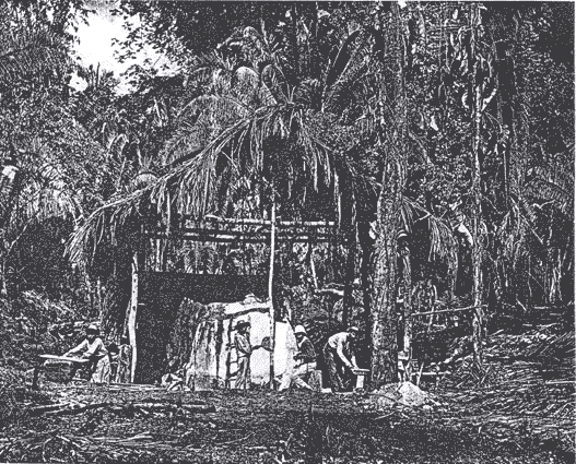