
Quetico Provincial Park
Encyclopedia
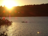
Quetico Provincial Park is a large wilderness
park in Northwestern Ontario
, Canada
, renowned for its excellent canoeing
and fishing
. This 4760 sqkm park shares its southern border with Minnesota
's Boundary Waters Canoe Area Wilderness
, which is part of the larger Superior National Forest
. These large wilderness parks are often collectively referred to as the Boundary Waters
or the Quetico-Superior Country.
s spread throughout more than 600 lakes. Canoeists require permit reservations and may only enter the Quetico via six Ranger Stations which serve 21 specific entry points. It is possible to drive to three of these Ranger Stations: Dawson Trail, Atikokan, Lac La Croix. One must portage
and paddle to Beaverhouse, and paddle or take a tow from an outfitter to Cache Bay or Prairie Portage. Drive-in camping is available only at the Dawson Trail campground; yurt
camping is available in this campground.
Most of the southern half of the Park is a region known historically as "Hunter Island
" (not a real island).
federal government established the adjacent Superior National Forest
and Superior Game Refuge, which eventually would become the Boundary Waters Canoe Area Wilderness
. Quetico Provincial Park was created in 1913 through passage of the Provincial Parks Act, although road access wasn't built until 1954.
The origin of the park's name is a mystery. Locals say the park is named after the "Quebec Timber Company"; however, no such company existed. The name may also be a version of the French
words quête de la côte which means "search for the coast". It may also be from an Ojibwe name for a benevolent spirit who resides in places of great beauty.
The park has been completely protected from logging
since 1971. Motor vehicles, including boats, were banned in the Quetico in 1979, with the exception of the Lac La Croix Guides Association, part of the Lac La Croix First Nation
, which is allowed to operate power boats with engines no more than 10 horsepower
(7.5 kW) on Quetico, Beaverhouse, Wolseley, Tanner, Minn, and McAree Lakes. The official plan (Agreement of Coexistence) is to phase out motorized guiding activities by the Lac La Croix First Nation in Quetico Provincial Park through simple attrition by the year 2015.
The new fishing regulations came into effect on 1 January 2008. These regulations state that only barbless hooks and artificial bait are permitted in the Park. "This means that no live or dead organic bait can be used in the park, including but not limited to leeches, worms, and salted minnows." Barbed hooks may be in a tackle box but must not be on the fishing line. Barbed hooks must be pinched before being attached to a fishing line. In effort to encourage park visitors to switch to "green" tackle, manufactured organic baits, barbless hooks, and lead-free tackle will be sold at all Quetico entry stations.
Hunting or molesting wildlife or possession of a firearm or fireworks is not allowed.
, an exposed 1000-mile expanse of ancient Precambrian
rock, some of which is among the oldest exposed rock in the world. The park consists of a large number of "young" lakes (only tens of thousands of years old) contained by this ancient bedrock. Due to its proximity to the Laurentian Divide
, the park can be considered to be in the headwaters of the Hudson Bay
watershed. The southern part of the park is drained by the Basswood River
, the central and eastern parts of the park by the Maligne River, and the northern part of the park by the Quetico River. All of these rivers flow into the Namakan River west of the park, which then flows into the Rainy River, Winnipeg River
, Nelson River
and finally into Hudson Bay
. This helps to make it, along with the adjacent Boundary Waters Canoe Area Wilderness
, the most popular canoe area in the world.
Wilderness
Wilderness or wildland is a natural environment on Earth that has not been significantly modified by human activity. It may also be defined as: "The most intact, undisturbed wild natural areas left on our planet—those last truly wild places that humans do not control and have not developed with...
park in Northwestern Ontario
Northwestern Ontario
Northwestern Ontario is the region within the Canadian province of Ontario which lies north and west of Lake Superior, and west of Hudson Bay and James Bay. It includes most of subarctic Ontario. Its western boundary is the Canadian province of Manitoba, which disputed Ontario's claim to the...
, Canada
Canada
Canada is a North American country consisting of ten provinces and three territories. Located in the northern part of the continent, it extends from the Atlantic Ocean in the east to the Pacific Ocean in the west, and northward into the Arctic Ocean...
, renowned for its excellent canoeing
Canoe camping
Canoe camping is a combination of canoeing and camping. It is similar to backpacking, but canoe campers travel by canoes or kayaks...
and fishing
Fishing
Fishing is the activity of trying to catch wild fish. Fish are normally caught in the wild. Techniques for catching fish include hand gathering, spearing, netting, angling and trapping....
. This 4760 sqkm park shares its southern border with Minnesota
Minnesota
Minnesota is a U.S. state located in the Midwestern United States. The twelfth largest state of the U.S., it is the twenty-first most populous, with 5.3 million residents. Minnesota was carved out of the eastern half of the Minnesota Territory and admitted to the Union as the thirty-second state...
's Boundary Waters Canoe Area Wilderness
Boundary Waters Canoe Area Wilderness
The Boundary Waters Canoe Area Wilderness , is a wilderness area within the Superior National Forest in northeastern Minnesota under the administration of the U.S. Forest Service...
, which is part of the larger Superior National Forest
Superior National Forest
Superior National Forest, part of the United States National Forest system, is located in the Arrowhead Region of the state of Minnesota between the Canada – United States border and the north shore of Lake Superior...
. These large wilderness parks are often collectively referred to as the Boundary Waters
Boundary Waters
The Boundary Waters — also called the Quetico-Superior country — is a region of wilderness straddling the Canada–United States border between Ontario and Minnesota, in the region just west of Lake Superior. This region is part of the Superior National Forest in northeastern Minnesota, and in Canada...
or the Quetico-Superior Country.
Geography
The park includes over 2000 unofficial, unimproved wilderness campsiteCampsite
A campsite or camping pitch is a place used for overnight stay in the outdoors. In British English a campsite is an area, usually divided into a number of pitches, where people can camp overnight using tents or camper vans or caravans; this British English use of the word is synonymous with the...
s spread throughout more than 600 lakes. Canoeists require permit reservations and may only enter the Quetico via six Ranger Stations which serve 21 specific entry points. It is possible to drive to three of these Ranger Stations: Dawson Trail, Atikokan, Lac La Croix. One must portage
Portage
Portage or portaging refers to the practice of carrying watercraft or cargo over land to avoid river obstacles, or between two bodies of water. A place where this carrying occurs is also called a portage; a person doing the carrying is called a porter.The English word portage is derived from the...
and paddle to Beaverhouse, and paddle or take a tow from an outfitter to Cache Bay or Prairie Portage. Drive-in camping is available only at the Dawson Trail campground; yurt
Yurt
A yurt is a portable, bent wood-framed dwelling structure traditionally used by Turkic nomads in the steppes of Central Asia. The structure comprises a crown or compression wheel usually steam bent, supported by roof ribs which are bent down at the end where they meet the lattice wall...
camping is available in this campground.
Most of the southern half of the Park is a region known historically as "Hunter Island
Hunter Island (Ontario)
Hunter Island, or Hunters Island, is a large land mass — now known to not be an actual island — which occupies the area between the two most historically significant fur trade waterway routes in northern Ontario, Canada: the Kaministiquia and the Grand Portage...
" (not a real island).
History
In 1909, an "Order in Council" by the Government of Ontario established the Quetico Forest Reserve. Early the same year, the United StatesUnited States
The United States of America is a federal constitutional republic comprising fifty states and a federal district...
federal government established the adjacent Superior National Forest
Superior National Forest
Superior National Forest, part of the United States National Forest system, is located in the Arrowhead Region of the state of Minnesota between the Canada – United States border and the north shore of Lake Superior...
and Superior Game Refuge, which eventually would become the Boundary Waters Canoe Area Wilderness
Boundary Waters Canoe Area Wilderness
The Boundary Waters Canoe Area Wilderness , is a wilderness area within the Superior National Forest in northeastern Minnesota under the administration of the U.S. Forest Service...
. Quetico Provincial Park was created in 1913 through passage of the Provincial Parks Act, although road access wasn't built until 1954.
The origin of the park's name is a mystery. Locals say the park is named after the "Quebec Timber Company"; however, no such company existed. The name may also be a version of the French
French language
French is a Romance language spoken as a first language in France, the Romandy region in Switzerland, Wallonia and Brussels in Belgium, Monaco, the regions of Quebec and Acadia in Canada, and by various communities elsewhere. Second-language speakers of French are distributed throughout many parts...
words quête de la côte which means "search for the coast". It may also be from an Ojibwe name for a benevolent spirit who resides in places of great beauty.
The park has been completely protected from logging
Logging
Logging is the cutting, skidding, on-site processing, and loading of trees or logs onto trucks.In forestry, the term logging is sometimes used in a narrow sense concerning the logistics of moving wood from the stump to somewhere outside the forest, usually a sawmill or a lumber yard...
since 1971. Motor vehicles, including boats, were banned in the Quetico in 1979, with the exception of the Lac La Croix Guides Association, part of the Lac La Croix First Nation
Lac La Croix First Nation
Lac La Croix First Nation is a Saulteaux First Nation located in Rainy River District in northwestern Ontario, Canada, along the Ontario-Minnesota border. It is approximately 200 km northwest of Thunder Bay, Ontario...
, which is allowed to operate power boats with engines no more than 10 horsepower
Horsepower
Horsepower is the name of several units of measurement of power. The most common definitions equal between 735.5 and 750 watts.Horsepower was originally defined to compare the output of steam engines with the power of draft horses in continuous operation. The unit was widely adopted to measure the...
(7.5 kW) on Quetico, Beaverhouse, Wolseley, Tanner, Minn, and McAree Lakes. The official plan (Agreement of Coexistence) is to phase out motorized guiding activities by the Lac La Croix First Nation in Quetico Provincial Park through simple attrition by the year 2015.
Regulations
As Quetico is a wilderness park there are restrictions that users must be aware of. Group size may not exceed 9 members. Containers of fuel, insect repellent, medicines, personal toilet articles, and other items that are not food or beverage are the only cans or bottles that may be brought into Quetico. It is an offence to possess non-burnable and non-reusable food or beverage containers. Mechanized devices such as power saws, generators, ice augers, or portage wheels are prohibited. It is furthermore illegal to damage live trees and other plants.The new fishing regulations came into effect on 1 January 2008. These regulations state that only barbless hooks and artificial bait are permitted in the Park. "This means that no live or dead organic bait can be used in the park, including but not limited to leeches, worms, and salted minnows." Barbed hooks may be in a tackle box but must not be on the fishing line. Barbed hooks must be pinched before being attached to a fishing line. In effort to encourage park visitors to switch to "green" tackle, manufactured organic baits, barbless hooks, and lead-free tackle will be sold at all Quetico entry stations.
Hunting or molesting wildlife or possession of a firearm or fireworks is not allowed.
Geology and drainage
Quetico is near the southern edge of the Canadian ShieldCanadian Shield
The Canadian Shield, also called the Laurentian Plateau, or Bouclier Canadien , is a vast geological shield covered by a thin layer of soil that forms the nucleus of the North American or Laurentia craton. It is an area mostly composed of igneous rock which relates to its long volcanic history...
, an exposed 1000-mile expanse of ancient Precambrian
Precambrian
The Precambrian is the name which describes the large span of time in Earth's history before the current Phanerozoic Eon, and is a Supereon divided into several eons of the geologic time scale...
rock, some of which is among the oldest exposed rock in the world. The park consists of a large number of "young" lakes (only tens of thousands of years old) contained by this ancient bedrock. Due to its proximity to the Laurentian Divide
Laurentian Divide
The Laurentian Divide or Northern Divide is a continental divide dividing the direction of water flow in eastern and southern Canada and the northern Midwestern United States. Water north of the height of land flows to the Arctic Ocean by rivers to Hudson Bay or directly to the Arctic...
, the park can be considered to be in the headwaters of the Hudson Bay
Hudson Bay
Hudson Bay , sometimes called Hudson's Bay, is a large body of saltwater in northeastern Canada. It drains a very large area, about , that includes parts of Ontario, Quebec, Saskatchewan, Alberta, most of Manitoba, southeastern Nunavut, as well as parts of North Dakota, South Dakota, Minnesota,...
watershed. The southern part of the park is drained by the Basswood River
Basswood River
-See also:*List of rivers of Minnesota-References:**USGS Hydrologic Unit Map - State of Minnesota...
, the central and eastern parts of the park by the Maligne River, and the northern part of the park by the Quetico River. All of these rivers flow into the Namakan River west of the park, which then flows into the Rainy River, Winnipeg River
Winnipeg River
The Winnipeg River is a Canadian river which flows from Lake of the Woods in the province of Ontario to Lake Winnipeg in Manitoba. This river is long from the Norman Dam in Kenora to its mouth at Lake Winnipeg. Its watershed is in area, mainly in Canada. About of this area is in northern...
, Nelson River
Nelson River
The Nelson River is a river of north-central North America, in the Canadian province of Manitoba. Its full length is , it has mean discharge of , and has a drainage basin of , of which is in the United States...
and finally into Hudson Bay
Hudson Bay
Hudson Bay , sometimes called Hudson's Bay, is a large body of saltwater in northeastern Canada. It drains a very large area, about , that includes parts of Ontario, Quebec, Saskatchewan, Alberta, most of Manitoba, southeastern Nunavut, as well as parts of North Dakota, South Dakota, Minnesota,...
. This helps to make it, along with the adjacent Boundary Waters Canoe Area Wilderness
Boundary Waters Canoe Area Wilderness
The Boundary Waters Canoe Area Wilderness , is a wilderness area within the Superior National Forest in northeastern Minnesota under the administration of the U.S. Forest Service...
, the most popular canoe area in the world.
See also
- Boundary WatersBoundary WatersThe Boundary Waters — also called the Quetico-Superior country — is a region of wilderness straddling the Canada–United States border between Ontario and Minnesota, in the region just west of Lake Superior. This region is part of the Superior National Forest in northeastern Minnesota, and in Canada...
- Boundary Waters Canoe Area WildernessBoundary Waters Canoe Area WildernessThe Boundary Waters Canoe Area Wilderness , is a wilderness area within the Superior National Forest in northeastern Minnesota under the administration of the U.S. Forest Service...
- La Verendrye Provincial ParkLa Verendrye Provincial ParkLa Verendrye Provincial Park is a waterway provincial park located in Ontario, Canada, on the border of Minnesota, USA. The park stretches from Quetico Provincial Park through Lake Saganaga, up the Pine River, across the Height of Land Portage, then down the Pigeon River to Pigeon River Provincial...
- Lake SaganagaLake SaganagaSaganaga Lake is a large lake on the Minnesota – Ontario international border. It is protected by the Boundary Waters Canoe Area Wilderness in the United States and by Quetico Provincial Park and La Verendrye Provincial Park in Canada....
- Voyageurs National ParkVoyageurs National ParkVoyageurs National Park is a United States National Park in northern Minnesota near the town of International Falls. It was established in 1975. The park's name commemorates the voyageurs, French-Canadian fur traders who were the first European settlers to frequently travel through the area...
- VoyageursVoyageursThe Voyageurs were the persons who engaged in the transportation of furs by canoe during the fur trade era. Voyageur is a French word which literally translates to "traveler"...