

Pájara
Encyclopedia
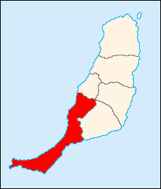 |
Pájara is a Canarian municipality in the central and the eastern portion of the island of Fuerteventura
Fuerteventura
Fuerteventura , a Spanish island, is one of the Canary Islands, in the Atlantic Ocean off the coast of Africa. It is situated at 28°20' north, 14°00' west. At 1,660 km² it is the second largest of the Canary Islands, after Tenerife...
in the Las Palmas
Las Palmas (province)
The Province of Las Palmas is a province of Spain, consisting of the eastern part of the autonomous community of the Canary Islands.-Composition:...
province in the Canary Islands
Canary Islands
The Canary Islands , also known as the Canaries , is a Spanish archipelago located just off the northwest coast of mainland Africa, 100 km west of the border between Morocco and the Western Sahara. The Canaries are a Spanish autonomous community and an outermost region of the European Union...
. Its population is 16,279 (ISTAC, 2003), its population density is 42.46/km² and its area is 383.52 km². The municipality includes a small peninsula to the southwest. Pájara is both the southernmost and the westernmost municipality on the island. The postal code is shared with Tuineje and is one of the few codes in the Canary Islands that is used by more than one municipality. Pájara is also the largest municipality on the island, as well as one of the largest in the province of Las Palmas. It is located on a main road linking northeast to Betancuria, Tuineje, Antigua and the northern part of the island. The main industry are agriculture and tourism. The Atlantic Ocean
Atlantic Ocean
The Atlantic Ocean is the second-largest of the world's oceanic divisions. With a total area of about , it covers approximately 20% of the Earth's surface and about 26% of its water surface area...
is to the west, south and east, the mountains covers much of the municipality including the north and east. Farmlands dominate the rest of the municipality.
The municipality of Pájara also contains a town called Pájara.
Geography
- Location:
- Latitude: 28.35 (28°21') N
- Longitude: 14.1 (14°6') W
- Altitude:
- Lowest: Atlantic Ocean
- Centre: 196 m
- Highest: northeastern
- Postal code: 35628
Other
The town of Pájara has schools, lyceums, gymnasia, churches, a post office, and a square (plaza). The stone work of sun pattern, snakes, panther and birds above the main entrance to the church of Nuestra Señora de Regla is thought by some specialists to show Aztec influenceAztec influence in Spain
Aztec influence in Spain can be seen in both the cuisine of Spain and in its architecture.-Food:Guacamole, an avocado-based dip that was popular in Aztec cuisine as early as the 16th century, was brought back to Spain by the Conquistadors...
.
External links
See also
- List of municipalities in Las Palmas
North: Betancuria Northeast: Tuineje Tuineje, Las PalmasTuineje is a Canarian municipality in the central and the eastern portion of the island of Fuerteventura in the Las Palmas province in the Canary Islands The population is 11,261 , its density is 40.81/km² and the area is 275.94 km². It is located a main highway linking Antigua and Pájara. The main...West: Atlantic Ocean Pájara East: Tuineje and the Atlantic Ocean South: Atlantic Ocean