
Pulau Sudong
Encyclopedia
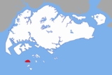
Pulau Sudong is a 209-hectare
coral
island
off the southern coast of Singapore
, it was enlarged through a land reclamation
process during the late 1970s.
and Pulau Pawai
, have formed the Singapore Armed Forces
southern islands military
training area and live-firing zone. (See Figure 1). As with all other military installations in Singapore, the entire live-firing zone is strictly off limits to all civilians at all times of the day and night. The only exceptions to this are for workers who are contracted by MINDEF to perform maintenance on the island's area calibration facilities.
The island's airstrip and dock
are maintained by SAF
, with most areas covered by dense vegetation - the island is a wildlife heaven for migratory birds and plants alike.
, a cone
-shaped food cover made from matting; it is also used as head covers by padi
planters.
The government
malaria
research station, originally on Pulau Belakang Mati, was on the island.

Hectare
The hectare is a metric unit of area defined as 10,000 square metres , and primarily used in the measurement of land. In 1795, when the metric system was introduced, the are was defined as being 100 square metres and the hectare was thus 100 ares or 1/100 km2...
coral
Coral
Corals are marine animals in class Anthozoa of phylum Cnidaria typically living in compact colonies of many identical individual "polyps". The group includes the important reef builders that inhabit tropical oceans and secrete calcium carbonate to form a hard skeleton.A coral "head" is a colony of...
island
Island
An island or isle is any piece of sub-continental land that is surrounded by water. Very small islands such as emergent land features on atolls can be called islets, cays or keys. An island in a river or lake may be called an eyot , or holm...
off the southern coast of Singapore
Singapore
Singapore , officially the Republic of Singapore, is a Southeast Asian city-state off the southern tip of the Malay Peninsula, north of the equator. An island country made up of 63 islands, it is separated from Malaysia by the Straits of Johor to its north and from Indonesia's Riau Islands by the...
, it was enlarged through a land reclamation
Land reclamation
Land reclamation, usually known as reclamation, is the process to create new land from sea or riverbeds. The land reclaimed is known as reclamation ground or landfill.- Habitation :...
process during the late 1970s.
Restricted area
Since the early 1980s, Pulau Sudong, together with Pulau SenangPulau Senang
Pulau Senang is a 81.7-hectare coral island about 13 kilometres off the southern coast of Singapore. Along with Pulau Pawai and Pulau Sudong, it is used as a military training area for live-fire exercises...
and Pulau Pawai
Pulau Pawai
Pulau Pawai, also known as Alligator Island during the colonial times, is a 182,000 m² island located within the Singapore Armed Forces Live Firing Area. It is located off the southwestern coast of Singapore, between Pulau Sudong to its north and Pulau Satumu to its south...
, have formed the Singapore Armed Forces
Singapore Armed Forces
The Singapore Armed Forces is the military arm of the Total Defence of the Republic of Singapore; as well as the military component of the Ministry of Defence. The SAF comprises three branches: the Singapore Army, the Republic of Singapore Air Force and the Republic of Singapore Navy...
southern islands military
Military
A military is an organization authorized by its greater society to use lethal force, usually including use of weapons, in defending its country by combating actual or perceived threats. The military may have additional functions of use to its greater society, such as advancing a political agenda e.g...
training area and live-firing zone. (See Figure 1). As with all other military installations in Singapore, the entire live-firing zone is strictly off limits to all civilians at all times of the day and night. The only exceptions to this are for workers who are contracted by MINDEF to perform maintenance on the island's area calibration facilities.
The island's airstrip and dock
Dock (maritime)
A dock is a human-made structure or group of structures involved in the handling of boats or ships, usually on or close to a shore.However, the exact meaning varies among different variants of the English language...
are maintained by SAF
Singapore Armed Forces
The Singapore Armed Forces is the military arm of the Total Defence of the Republic of Singapore; as well as the military component of the Ministry of Defence. The SAF comprises three branches: the Singapore Army, the Republic of Singapore Air Force and the Republic of Singapore Navy...
, with most areas covered by dense vegetation - the island is a wildlife heaven for migratory birds and plants alike.
Etymology and history
Sudong is the same as tudong in MalayMalay language
Malay is a major language of the Austronesian family. It is the official language of Malaysia , Indonesia , Brunei and Singapore...
, a cone
Cone (geometry)
A cone is an n-dimensional geometric shape that tapers smoothly from a base to a point called the apex or vertex. Formally, it is the solid figure formed by the locus of all straight line segments that join the apex to the base...
-shaped food cover made from matting; it is also used as head covers by padi
Rice
Rice is the seed of the monocot plants Oryza sativa or Oryza glaberrima . As a cereal grain, it is the most important staple food for a large part of the world's human population, especially in East Asia, Southeast Asia, South Asia, the Middle East, and the West Indies...
planters.
The government
Government of Singapore
The Government of Singapore is defined by the Constitution of the Republic of Singapore to mean the Executive branch of government, which is made up of the President and the Cabinet of Singapore. Although the President acts in his personal discretion in the exercise of certain functions as a check...
malaria
Malaria
Malaria is a mosquito-borne infectious disease of humans and other animals caused by eukaryotic protists of the genus Plasmodium. The disease results from the multiplication of Plasmodium parasites within red blood cells, causing symptoms that typically include fever and headache, in severe cases...
research station, originally on Pulau Belakang Mati, was on the island.
Panoramic image
External links
- Satellite image of Pulau Sudong - Google MapsGoogle MapsGoogle Maps is a web mapping service application and technology provided by Google, free , that powers many map-based services, including the Google Maps website, Google Ride Finder, Google Transit, and maps embedded on third-party websites via the Google Maps API...