
Pukapuka
Encyclopedia


Coral
Corals are marine animals in class Anthozoa of phylum Cnidaria typically living in compact colonies of many identical individual "polyps". The group includes the important reef builders that inhabit tropical oceans and secrete calcium carbonate to form a hard skeleton.A coral "head" is a colony of...
atoll
Atoll
An atoll is a coral island that encircles a lagoon partially or completely.- Usage :The word atoll comes from the Dhivehi word atholhu OED...
in the Cook Islands
Cook Islands
The Cook Islands is a self-governing parliamentary democracy in the South Pacific Ocean in free association with New Zealand...
in the Pacific Ocean
Pacific Ocean
The Pacific Ocean is the largest of the Earth's oceanic divisions. It extends from the Arctic in the north to the Southern Ocean in the south, bounded by Asia and Australia in the west, and the Americas in the east.At 165.2 million square kilometres in area, this largest division of the World...
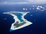
, with three small islets threaded on a reef that encloses a beautifully clear lagoon. It is the most remote island of the Cook Islands, situated about 1140 kilometres northwest of Rarotonga. It is a triangular atoll with three islets comprising little more than 3 square kilometres of land area. On this small island an ancient culture and distinct language has been maintained over many centuries. In the 1990s Japanese archaeologists discovered evidence of human settlement approximately 2,000 years ago. Pukapuka's closest prehistoric associations appear to be with Samoa and other islands to the west. The traditional name for the atoll was Te Ulu-o-Te-Watu ('the head of the stone'), and the northern islet where the people normally reside is affectionately known as Wale (Home).
European visitors
Pukapuka has the distinction of being the first of the Cook Islands to be sighted by Europeans. The Spanish explorer Alvaro de Mendana de NeiraÁlvaro de Mendaña de Neira
Álvaro de Mendaña de Neira was a Spanish navigator. Born in Congosto, in León, he was the nephew of Lope García de Castro, viceroy of Peru...
saw it on Saint Bernard's day, Sunday 20 August 1595 and named it San Bernardo.
On 21 June 1765 the British Naval expedition under Commodore John Byron (Dolphin and Tamar) sighted the island. Byron gave the name "Islands of Danger" because of the high surf that made it too dangerous to land. The name "Danger Island" still appears on some maps. (It should not be confused with Danger Island
Danger Island
Danger Island is the westernmost and the southernmost island of the Great Chagos Bank, which is the world's largest coral atoll structure, located in the Chagos Archipelago.-Description:...
of the Chagos Archipelago
Chagos Archipelago
The Chagos Archipelago , is a group of seven atolls comprising more than 60 individual tropical islands in the Indian Ocean; situated some due south of the Maldives archipelago. This chain of islands are the southernmost archipelago of the Chagos-Laccadive Ridge a long submarine mountain range...
in the Indian Ocean
Indian Ocean
The Indian Ocean is the third largest of the world's oceanic divisions, covering approximately 20% of the water on the Earth's surface. It is bounded on the north by the Indian Subcontinent and Arabian Peninsula ; on the west by eastern Africa; on the east by Indochina, the Sunda Islands, and...
.) According to oral tradition, an unknown ship called at Pukapuka in the late 18th century, and when the lineage chief Tawaki boldly took the captain's pipe, he was shot.
Thirty years later, Pukapuka was given the name "Isles de la Loutre" (Isles of the Otter) by Pierre François Péron
Pierre François Péron
French Captain Pierre François Péron, born in 1769 at Lambézellec, near Brest, was a French sailor and trading captain who sailed to many different locations in the late 18th century...
, the first mate on board the American merchant ship, Otter (ship)
Otter (ship)
The Otter was a maritime fur trading vessel which was most famous for the rescue, under command of Capt. Ebenezer Dorr , of Thomas Muir, a famous Scottish political exile....
(Captain Ebenezer Dorr) when it was sighted on 3 April 1796. The following day, Peron, Thomas Muir
Thomas Muir (radical)
Thomas Muir was a Scottish political reformer.Muir was the son of James Muir, a hop merchant, and was educated at Glasgow Grammar School, before attending the University of Glasgow to study divinity...
of Huntershill (1765–1799) and a small party landed ashore but the inhabitants would not allow them to inspect the island. Trading later took place near the ship as adzes, mats and other artifacts were exchanged for knives and European goods.
Due to Pukapuka's isolation, very few vessels visited it before 1857 when the London Missionary Society landed teachers from Rarotonga and Aitutaki. In 1862, Rev. Wyatt W. Gill found most of the people on the island converted to Christianity. Peruvian slavers raided the island in early 1863 and took away a total of 145 men and women; only two returned. The English missionary barque John Williams was wrecked on the west side in May 1864.
In 1868 the buccaneer Bully Hayes took about 40 people on a labour scheme, but none of them returned home.
World War II
Three downed U.S. Navy fliers landed on Pukapuka in February 1942. Harold Dixon, Gene Aldrich, and Tony Pastula survived 34 days on the open ocean in a tiny 4 by raft, beginning their odyssey with no food or water stores and very few tools. Shortly after their arrival a typhoon struck the island. Their story has been called "…unquestionably one of the most grueling and fantastic ordeals of World War II."Geography
Pukapuka is shaped like a three bladed fan. There are three islets on the roughly triangular reef. Motu Ko, the biggest island is to the southeast; Motu Kotawa (Frigate Bird Island) is to the southwest; and the main island Wale is to the north. Ko and Kotawa are uninhabited and are used for growing food. The airport (ICAO airport codeICAO airport code
The ICAO airport code or location indicator is a four-character alphanumeric code designating each airport around the world. These codes are defined by the International Civil Aviation Organization, and published in ICAO Document 7910: Location Indicators.The ICAO codes are used by air traffic...
: NCPK) is on Ko.
The three villages are located on the crescent-shaped bay of the northernmost islet of the atoll: Yato (Leeward), Loto (Central) and Ngake (East). Loto (Roto on most maps) is host to Island Administration. The traditional names for these villages are Takanumi, Kotipolo and Te Langaikula. In daily life, the islanders frequently call them Tiapani (Japan
Japan
Japan is an island nation in East Asia. Located in the Pacific Ocean, it lies to the east of the Sea of Japan, China, North Korea, South Korea and Russia, stretching from the Sea of Okhotsk in the north to the East China Sea and Taiwan in the south...
), Malike or Amelika (USA) and Olani (Holland) respectively. Especially in sports competitions between the villages, the villagers use the names and flags of these countries.
Although the island features a well-maintained airstrip, flights from Rarotonga are very infrequent. The five hour flight from Rarotonga now operates when there is a Government charter once every six weeks or so. The island is closer to Samoa
Samoa
Samoa , officially the Independent State of Samoa, formerly known as Western Samoa is a country encompassing the western part of the Samoan Islands in the South Pacific Ocean. It became independent from New Zealand in 1962. The two main islands of Samoa are Upolu and one of the biggest islands in...
than to the rest of the Cook Islands
Cook Islands
The Cook Islands is a self-governing parliamentary democracy in the South Pacific Ocean in free association with New Zealand...
and transport via Samoa is becoming a preferred option for Pukapukans visiting in organised groups (tele parties) from New Zealand and Australia.
The submerged Tema Reef
Tema Reef
Tema Reef, also called Tima Reef, is a submerged coral reef in the northern Cook Islands, 23 km southeast of Pukapuka.No coral or rock shows above water, but the sea breaks heavily over the reef....
is situated 23 km southeast of Pukapuka. About 60 km away is Nassau (Cook Islands)
Nassau (Cook Islands)
Nassau is an island in the Cook Islands.Located 90 km south of Pukapuka, the small island of Nassau is just 9 metres above sea level, with an oval sandy cay on a coral reef foundation and is surrounded by a narrow reef flat. It is covered with palms, and is the only island of the Northern...
which is owned by the people of Pukapuka and considered part of it administratively. Since the 1950s it has been governed by a Council of Chiefs of Pukapuka. The Nassau Island Committee advises the Pukapuka Island Committee on matters relating to its own island.
Pukapuka and Nassau were hit by Cyclone Percy
Cyclone Percy
Cyclone Percy was the seventh named storm of the 2004-05 South Pacific cyclone season and the fourth and final cyclone to form during the February 2005 outbreak in the South Pacific Ocean....
in February 2005 — a Category Four cyclone that destroyed the taro gardens, brought down thousands of trees, and damaged three-quarters of the houses.
Treaty
The United StatesUnited States
The United States of America is a federal constitutional republic comprising fifty states and a federal district...
gave up its claim to the island in a treaty
Cook Islands – United States Maritime Boundary Treaty
The Cook Islands – United States Maritime Boundary Treaty is a 1980 treaty that establishes the maritime boundary between the Cook Islands and American Samoa. It resolved a number of territorial disputes between the Cook Islands and the United States....
signed with the Cook Islands
Cook Islands
The Cook Islands is a self-governing parliamentary democracy in the South Pacific Ocean in free association with New Zealand...
on 11 June 1980.
Culture
Pukapuka has its own language and customs that are different from the rest of the Cook Islands.The entire population is said to be descended from seventeen men, two women and an unknown number of children who survived a catastrophic storm and seismic wave (tsunami
Tsunami
A tsunami is a series of water waves caused by the displacement of a large volume of a body of water, typically an ocean or a large lake...
) in the 17th century. The description of the tragedy, complete with thunder and lightning, is more in keeping with a cyclone, and the waves it generated swept most of the people away. A new estimate of the date of the calamity based on genealogical records suggests that it happened about 1700.
664 people inhabited the island as of the 2001 census, but since 2005 the population has declined to about 500.
The American writer Robert Dean Frisbie
Robert Dean Frisbie
Robert Dean Frisbie was an American writer of travel literature about Polynesia.-Life:...
settled on Pukapuka in 1924 and immortalised the island in the books he wrote about it. He said at the time he was looking for a place beyond the reach of "the faintest echo from the noisy clamour of the civilised world". He found it, and to this day Pukapuka is one of the most untouched and secluded places in the Cook Islands.