
Puget Sound region
Encyclopedia
The Puget Sound region is an inland area of the Pacific Northwest
in Washington (State), including Puget Sound
, the Puget Sound lowlands, and the surrounding region roughly west of the Cascade Range
and east of the Olympic Mountains
.
 The Puget Sound region was formed by the collision and attachment of many terrane
s ("microcontinents") to the North American Plate
between about 50 to 10 million years ago. About 15,000 years ago, the Puget Sound region was covered by a lobe of the Cordilleran Ice Sheet
. The ice was about 3000 feet (914.4 m) in the vicinity of Seattle. By the time Captain George Vancouver found the Sound, early native people had already been there for over 5,000 years.
Logging started as early as 1853. In the 1880s logging railroads cut their way into Puget sound. 1886 the St. Helens fire burned 300000 acres (1,214.1 km²). Mount Rainier National Park started in 1899. The 1902 Yacolt fire burned 600000 acres (2,428.1 km²). Olympic National Park in 1938.
George Vancouver explored Puget Sound in 1792. Vancouver claimed it for Great Britain
on 4 June 1792, naming it for one of his officers, Lieutenant Peter Puget
. It became part of the Oregon Country
, and became U.S. territory when the 1846 Oregon Treaty
was signed.
After arriving along the Oregon Trail
, many settlers wandered north to what is now Washington State and settled the Puget Sound area. The first non-indigenous settlement was New Market (now known as Tumwater
) in 1846. In 1853 Washington Territory
was formed from part of Oregon Territory
. In 1888 the Northern Pacific railroad line reached Puget Sound, linking the region to eastern states.
For a long period Tacoma was noted for its large smelters where gold, silver, copper and lead ores were treated. Seattle was the primary port for trade with Alaska
and the rest of the country and for a time possessed a large shipbuilding industry. The region around eastern Puget Sound developed heavy industry during the period including World War I
and World War II
, and the Boeing Company
became an established icon in the area.
During World War II the Puget Sound area became a focus for the war industry, with Boeing producing many of the nation's heavy bomber
s and the ports of Seattle, Bremerton
and Tacoma available for shipbuilding.
Since 1995, Puget Sound has been recognized as an American Viticultural Area
by the Alcohol and Tobacco Tax and Trade Bureau
.
 The United States Geological Survey
(USGS) defines Puget Sound as a bay
with numerous channels and branches; more specifically, it is a fjord
system of flooded glacial valleys. Puget Sound is part of a larger physiographic structure
termed the Puget Trough, which is a physiographic section of the larger Pacific Border province
, which in turn is part of the larger Pacific Mountain System
.
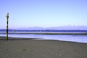
Puget Sound is a large salt water estuary
, or system of many estuaries, fed by highly seasonal freshwater from the Olympic and Cascade mountain watersheds. Puget Sound is connected to the Strait of Juan de Fuca
to the north at Admiralty Inlet
, between Point Partridge on Whidbey Island
and Point Wilson on the Olympic Peninsula
. A second connection is Deception Pass
, between West Point on Whidbey Island and Rosario Head on Fidalgo Island
.
Continental ice sheet
s have repeatedly advanced and retreated from the Puget Sound region. During the most recent glacial period
, called the Fraser Glaciation, which had three phases, or stades
. During the third, or Vashon Glaciation, a lobe of the Cordilleran Ice Sheet
, called the Puget Lobe, spread south about 15,000 years ago, covering the Puget Sound region with an ice sheet about 3000 feet (914.4 m) thick near Seattle, and nearly 6000 feet (1,828.8 m) at the present Canada-US border. Since each new advance of ice scours away much of the evidence of previous ice ages, the most recent Vashon phase has left the clearest imprint on the land. At its maximum extent the Vashon ice sheet extended south of Olympia
to near Tenino
, and covered the lowlands between the Olympic and Cascade mountains. About 14,000 years ago the ice began to retreat. By 11,000 years ago it survived only north of the Canadian border.
The Vashon Glaciation scoured the land, creating a drumlin field
of hundreds of aligned drumlin
hills. Lake Washington
and Lake Sammamish
(which are ribbon lake
s), Hood Canal, and the main Puget Sound basin were carved out by glacial forces. As the ice retreated, vast amounts of glacial till
were deposited throughout the Puget Sound region. The soils of the region, less than ten thousand years old, are still characterized as immature.
As the Vashon glacier receded a series of proglacial lake
s formed, filling the main trough of Puget Sound and inundating the southern lowlands. Glacial Lake Russell was the first such large recessional lake. From the vicinity of Seattle in the north the lake extended south to the Black Hills
, where it drained south into the Chehalis River. Sediments from Lake Russell form the blue-gray clay identified as the Lawton Clay. The second major recessional lake was Glacial Lake Bretz. It also drained to the Chehalis River until the Chimacum Valley, in the northeast Olympic Peninsula
, melted, allowing the lake's water to rapidly drain north into the marine waters of the Strait of Juan de Fuca, which was rising as the ice sheet retreated.
As icebergs calved
off the toe of the glacier, their embedded gravels and boulders were deposited in the chaotic mix of unsorted till
geologists call glaciomarine drift. Many beaches about the Sound display glacial erratic
s, rendered more prominent than those in coastal woodland solely by their exposed position; submerged glacial erratics sometimes provide hazards to navigation. The sheer weight of glacial-age ice depressed the landforms, which experienced post-glacial rebound
after the ice sheets had retreated. Because the rate of rebound was not synchronous with the post-ice age rise in sea levels, the bed of what is Puget Sound, filled alternately with fresh and with sea water. The upper level of the lake-sediment Lawton Clay now lies about 120 feet (36.6 m) above sea level.
 The Puget Sound system consists of four deep basins connected by shallower sills. The four basins are Hood Canal, west of the Kitsap Peninsula, Whidbey Basin, east of Whidbey Island, South Sound, south of the Tacoma Narrows, and the Main Basin, which is further subdivided into Admiralty Inlet and the Central Basin. Puget Sound's sills, a kind of submarine terminal moraine
, separate the basins from one another, and Puget Sound from the Strait of Juan de Fuca. Three sills are particularly significant — the one at Admiralty Inlet which checks the flow of water between the Strait of Juan de Fuca and Puget sound, the one at the entrance to Hood Canal (about 175 ft (53.3 m) below the surface), and the one at the Tacoma Narrows (about 145 ft (44.2 m)). Other sills that present less of a barrier include the ones at Blake Island
, Agate Pass
, Rich Passage
, and Hammersley Inlet
.
The depth of the basins is a result of the Sound being part of the Cascadia subduction zone
, where the terrane
s accreted at the edge of the Juan de Fuca Plate
are being subducted
under the North American Plate
: there has not been a major subduction zone earthquake
here since the magnitude
nine Cascadia Earthquake
; according to Japan
ese records, it occurred 26 January 1700. Lesser Puget Sound earthquake
s with shallow epicenter
s, caused by the fracturing of stressed oceanic rocks as they are subducted still cause great damage. The Seattle Fault
cuts across Puget Sound, crossing just north of Vashon Island
and dipping under the city of Seattle. To the south, the existence of a second fault, the Tacoma Fault
has buckled the intervening strata in the Seattle Uplift.
Typical Puget Sound profiles of dense glacial till overlying permeable glacial outwash of gravels above an impermeable bed of silty clay may become unstable after periods of unusually wet weather and slump in landslides.
and four satellite cities making up what has been dubbed "Pugetopolis". Both urban core cities have large industrial areas and seaports plus a high-rise central business district
. The satellite cities are primarily suburb
an, featuring a small downtown core and a small industrial area or port. The suburbs consist mostly of residences, strip mall
s, and shopping centers. The region is also home to numerous ports. The two largest and busiest are the Port of Seattle
and Port of Tacoma
, which, if combined, comprise the third largest container port in North America after Los Angeles/Long Beach and New York/New Jersey.
A state-run ferry system, Washington State Ferries
, connects the larger islands to the Washington mainland, as well as both sides of the sound, allowing cars and people to move about the greater Puget Sound region.
Geoduck
(goo-ey-duck) : It is estimated that more than 100 million geoducks are packed into Puget Sound's sediments. Also known as "king clam," geoducks are considered to be a delicacy in Asian countries.
In addition, the San Juan Islands
(all of San Juan County plus a few islands belonging to Whatcom County
) are often considered part of the greater Puget Sound area.
Pacific Northwest
The Pacific Northwest is a region in northwestern North America, bounded by the Pacific Ocean to the west and, loosely, by the Rocky Mountains on the east. Definitions of the region vary and there is no commonly agreed upon boundary, even among Pacific Northwesterners. A common concept of the...
in Washington (State), including Puget Sound
Puget Sound
Puget Sound is a sound in the U.S. state of Washington. It is a complex estuarine system of interconnected marine waterways and basins, with one major and one minor connection to the Strait of Juan de Fuca and the Pacific Ocean — Admiralty Inlet being the major connection and...
, the Puget Sound lowlands, and the surrounding region roughly west of the Cascade Range
Cascade Range
The Cascade Range is a major mountain range of western North America, extending from southern British Columbia through Washington and Oregon to Northern California. It includes both non-volcanic mountains, such as the North Cascades, and the notable volcanoes known as the High Cascades...
and east of the Olympic Mountains
Olympic Mountains
The Olympic Mountains is a mountain range on the Olympic Peninsula of western Washington in the United States. The mountains, part of the Pacific Coast Ranges, are not especially high - Mount Olympus is the highest at - but the western slopes of the Olympics rise directly out of the Pacific...
.
History
Terrane
A terrane in geology is short-hand term for a tectonostratigraphic terrane, which is a fragment of crustal material formed on, or broken off from, one tectonic plate and accreted or "sutured" to crust lying on another plate...
s ("microcontinents") to the North American Plate
North American Plate
The North American Plate is a tectonic plate covering most of North America, Greenland, Cuba, Bahamas, and parts of Siberia, Japan and Iceland. It extends eastward to the Mid-Atlantic Ridge and westward to the Chersky Range in eastern Siberia. The plate includes both continental and oceanic crust...
between about 50 to 10 million years ago. About 15,000 years ago, the Puget Sound region was covered by a lobe of the Cordilleran Ice Sheet
Cordilleran Ice Sheet
The Cordilleran ice sheet was a major ice sheet that covered, during glacial periods of the Quaternary, a large area of North America. This included the following areas:*Western Montana*The Idaho Panhandle...
. The ice was about 3000 feet (914.4 m) in the vicinity of Seattle. By the time Captain George Vancouver found the Sound, early native people had already been there for over 5,000 years.
Logging started as early as 1853. In the 1880s logging railroads cut their way into Puget sound. 1886 the St. Helens fire burned 300000 acres (1,214.1 km²). Mount Rainier National Park started in 1899. The 1902 Yacolt fire burned 600000 acres (2,428.1 km²). Olympic National Park in 1938.
George Vancouver explored Puget Sound in 1792. Vancouver claimed it for Great Britain
Kingdom of Great Britain
The former Kingdom of Great Britain, sometimes described as the 'United Kingdom of Great Britain', That the Two Kingdoms of Scotland and England, shall upon the 1st May next ensuing the date hereof, and forever after, be United into One Kingdom by the Name of GREAT BRITAIN. was a sovereign...
on 4 June 1792, naming it for one of his officers, Lieutenant Peter Puget
Peter Puget
Peter Puget was an officer in the Royal Navy, best known for his exploration of Puget Sound.-Mr. Midshipman Puget:Puget's ancestors had fled France for Britain during Louis XIV's persecution of the Huguenots. His father, John, was a successful merchant and banker, but died in 1767, leaving Puget's...
. It became part of the Oregon Country
Oregon Country
The Oregon Country was a predominantly American term referring to a disputed ownership region of the Pacific Northwest of North America. The region was occupied by British and French Canadian fur traders from before 1810, and American settlers from the mid-1830s, with its coastal areas north from...
, and became U.S. territory when the 1846 Oregon Treaty
Oregon Treaty
The Oregon Treaty is a treaty between the United Kingdom and the United States that was signed on June 15, 1846, in Washington, D.C. The treaty brought an end to the Oregon boundary dispute by settling competing American and British claims to the Oregon Country, which had been jointly occupied by...
was signed.
After arriving along the Oregon Trail
Oregon Trail
The Oregon Trail is a historic east-west wagon route that connected the Missouri River to valleys in Oregon and locations in between.After 1840 steam-powered riverboats and steamboats traversing up and down the Ohio, Mississippi and Missouri rivers sped settlement and development in the flat...
, many settlers wandered north to what is now Washington State and settled the Puget Sound area. The first non-indigenous settlement was New Market (now known as Tumwater
Tumwater, Washington
Tumwater is a city in Thurston County, Washington, United States. It lies near where the Deschutes River enters Budd Inlet, the southernmost point of Puget Sound. The population was 17,371 at the 2010 census...
) in 1846. In 1853 Washington Territory
Washington Territory
The Territory of Washington was an organized incorporated territory of the United States that existed from February 8, 1853, until November 11, 1889, when the final extent of the territory was admitted to the Union as the State of Washington....
was formed from part of Oregon Territory
Oregon Territory
The Territory of Oregon was an organized incorporated territory of the United States that existed from August 14, 1848, until February 14, 1859, when the southwestern portion of the territory was admitted to the Union as the State of Oregon. Originally claimed by several countries , the region was...
. In 1888 the Northern Pacific railroad line reached Puget Sound, linking the region to eastern states.
For a long period Tacoma was noted for its large smelters where gold, silver, copper and lead ores were treated. Seattle was the primary port for trade with Alaska
Alaska
Alaska is the largest state in the United States by area. It is situated in the northwest extremity of the North American continent, with Canada to the east, the Arctic Ocean to the north, and the Pacific Ocean to the west and south, with Russia further west across the Bering Strait...
and the rest of the country and for a time possessed a large shipbuilding industry. The region around eastern Puget Sound developed heavy industry during the period including World War I
World War I
World War I , which was predominantly called the World War or the Great War from its occurrence until 1939, and the First World War or World War I thereafter, was a major war centred in Europe that began on 28 July 1914 and lasted until 11 November 1918...
and World War II
World War II
World War II, or the Second World War , was a global conflict lasting from 1939 to 1945, involving most of the world's nations—including all of the great powers—eventually forming two opposing military alliances: the Allies and the Axis...
, and the Boeing Company
Boeing
The Boeing Company is an American multinational aerospace and defense corporation, founded in 1916 by William E. Boeing in Seattle, Washington. Boeing has expanded over the years, merging with McDonnell Douglas in 1997. Boeing Corporate headquarters has been in Chicago, Illinois since 2001...
became an established icon in the area.
During World War II the Puget Sound area became a focus for the war industry, with Boeing producing many of the nation's heavy bomber
Heavy bomber
A heavy bomber is a bomber aircraft of the largest size and load carrying capacity, and usually the longest range.In New START, the term "heavy bomber" is used for two types of bombers:*one with a range greater than 8,000 kilometers...
s and the ports of Seattle, Bremerton
Bremerton, Washington
Bremerton is a city in Kitsap County, Washington, United States. The population was 38,790 at the 2011 State Estimate, making it the largest city on the Olympic Peninsula. Bremerton is home to Puget Sound Naval Shipyard and the Bremerton Annex of Naval Base Kitsap...
and Tacoma available for shipbuilding.
Since 1995, Puget Sound has been recognized as an American Viticultural Area
American Viticultural Area
An American Viticultural Area is a designated wine grape-growing region in the United States distinguishable by geographic features, with boundaries defined by the Alcohol and Tobacco Tax and Trade Bureau , United States Department of the Treasury....
by the Alcohol and Tobacco Tax and Trade Bureau
Alcohol and Tobacco Tax and Trade Bureau
The Alcohol and Tobacco Tax and Trade Bureau, statutorily named the Tax and Trade Bureau and frequently shortened to TTB, is a bureau of the United States Department of the Treasury....
.
Physical geography
United States Geological Survey
The United States Geological Survey is a scientific agency of the United States government. The scientists of the USGS study the landscape of the United States, its natural resources, and the natural hazards that threaten it. The organization has four major science disciplines, concerning biology,...
(USGS) defines Puget Sound as a bay
Headlands and bays
Headlands and bays are two related features of the coastal environment.- Geology and geography :Headlands and bays are often found on the same coastline. A bay is surrounded by land on three sides, whereas a headland is surrounded by water on three sides. Headlands are characterized by high,...
with numerous channels and branches; more specifically, it is a fjord
Fjord
Geologically, a fjord is a long, narrow inlet with steep sides or cliffs, created in a valley carved by glacial activity.-Formation:A fjord is formed when a glacier cuts a U-shaped valley by abrasion of the surrounding bedrock. Glacial melting is accompanied by rebound of Earth's crust as the ice...
system of flooded glacial valleys. Puget Sound is part of a larger physiographic structure
Physiographic regions of the world
The physiographic regions of the world are a means of defining the Earth's landforms into distinct regions based upon classic 1916 three-tiered approach defining divisions, provinces, and sections...
termed the Puget Trough, which is a physiographic section of the larger Pacific Border province
Pacific Border province
The Pacific Border province is a physiographic province of the Physiographic regions of the world physical geography system.-Description:The Pacific Border province encompasses most of the North American Pacific Coast, with the southern end at the start of the Lower California-Peninsular Ranges...
, which in turn is part of the larger Pacific Mountain System
Pacific Coast Ranges
The Pacific Coast Ranges and the Pacific Mountain System are the series of mountain ranges that stretch along the West Coast of North America from Alaska south to Northern and Central Mexico...
.
Puget Sound is a large salt water estuary
Estuary
An estuary is a partly enclosed coastal body of water with one or more rivers or streams flowing into it, and with a free connection to the open sea....
, or system of many estuaries, fed by highly seasonal freshwater from the Olympic and Cascade mountain watersheds. Puget Sound is connected to the Strait of Juan de Fuca
Strait of Juan de Fuca
The Strait of Juan de Fuca is a large body of water about long that is the Salish Sea outlet to the Pacific Ocean...
to the north at Admiralty Inlet
Admiralty Inlet
Admiralty Inlet is a strait in the U.S. state of Washington connecting the eastern end of the Strait of Juan de Fuca to Puget Sound. It lies between Whidbey Island and the northeastern part of the Olympic Peninsula....
, between Point Partridge on Whidbey Island
Whidbey Island
Whidbey Island is one of nine islands located in Island County, Washington, in the United States. Whidbey is located about north of Seattle, and lies between the Olympic Peninsula and the I-5 corridor of western Washington...
and Point Wilson on the Olympic Peninsula
Olympic Peninsula
The Olympic Peninsula is the large arm of land in western Washington state of the USA, that lies across Puget Sound from Seattle. It is bounded on the west by the Pacific Ocean, the north by the Strait of Juan de Fuca, and the east by Puget Sound. Cape Alava, the westernmost point in the contiguous...
. A second connection is Deception Pass
Deception Pass
Deception Pass is a strait separating Whidbey Island from Fidalgo Island, in the northwest part of the U.S. state of Washington. It connects Skagit Bay, part of Puget Sound, with the Strait of Juan de Fuca.-History:...
, between West Point on Whidbey Island and Rosario Head on Fidalgo Island
Fidalgo Island
Fidalgo Island is an island in Skagit County, Washington, located about north of Seattle. To the east, it is separated from the mainland by the Swinomish Channel, and from Whidbey Island to the south by Deception Pass...
.
Continental ice sheet
Ice sheet
An ice sheet is a mass of glacier ice that covers surrounding terrain and is greater than 50,000 km² , thus also known as continental glacier...
s have repeatedly advanced and retreated from the Puget Sound region. During the most recent glacial period
Glacial period
A glacial period is an interval of time within an ice age that is marked by colder temperatures and glacier advances. Interglacials, on the other hand, are periods of warmer climate within an ice age...
, called the Fraser Glaciation, which had three phases, or stades
Stadial
A stadial is a period of lower temperatures during an interglacial separating the glacial periods of an ice age. Such periods are of insufficient duration or intensity to be considered glacial periods...
. During the third, or Vashon Glaciation, a lobe of the Cordilleran Ice Sheet
Cordilleran Ice Sheet
The Cordilleran ice sheet was a major ice sheet that covered, during glacial periods of the Quaternary, a large area of North America. This included the following areas:*Western Montana*The Idaho Panhandle...
, called the Puget Lobe, spread south about 15,000 years ago, covering the Puget Sound region with an ice sheet about 3000 feet (914.4 m) thick near Seattle, and nearly 6000 feet (1,828.8 m) at the present Canada-US border. Since each new advance of ice scours away much of the evidence of previous ice ages, the most recent Vashon phase has left the clearest imprint on the land. At its maximum extent the Vashon ice sheet extended south of Olympia
Olympia, Washington
Olympia is the capital city of the U.S. state of Washington and the county seat of Thurston County. It was incorporated on January 28, 1859. The population was 46,478 at the 2010 census...
to near Tenino
Tenino, Washington
Tenino is a city in Thurston County, Washington, United States. The population was 1,695 at the 2010 census.-History:Tenino was officially incorporated on July 24, 1906, though it existed as a rural community since the mid-19th century...
, and covered the lowlands between the Olympic and Cascade mountains. About 14,000 years ago the ice began to retreat. By 11,000 years ago it survived only north of the Canadian border.
The Vashon Glaciation scoured the land, creating a drumlin field
Drumlin field
A drumlin field is a cluster of dozens to hundreds of similarly shaped, sized and oriented drumlins, also called a drumlin swarm. Drumlins are one type of landform that indicate continental ice sheet glaciation...
of hundreds of aligned drumlin
Drumlin
A drumlin, from the Irish word droimnín , first recorded in 1833, is an elongated whale-shaped hill formed by glacial ice acting on underlying unconsolidated till or ground moraine.-Drumlin formation:...
hills. Lake Washington
Lake Washington
Lake Washington is a large freshwater lake adjacent to the city of Seattle. It is the largest lake in King County and the second largest in the state of Washington, after Lake Chelan. It is bordered by the cities of Seattle on the west, Bellevue and Kirkland on the east, Renton on the south and...
and Lake Sammamish
Lake Sammamish
Lake Sammamish is a freshwater lake east of Seattle in King County, Washington, United States. The lake is long and wide, with a maximum depth of and a surface area of . It lies east of Lake Washington and west of the Sammamish Plateau, and stretches from Issaquah in the south to Redmond in...
(which are ribbon lake
Ribbon lake
A ribbon lake or loch is a long and narrow, finger-shaped lake, usually found in a glacial trough. Its formation begins when a glacier moves over an area containing alternate bands of hard and soft bedrock...
s), Hood Canal, and the main Puget Sound basin were carved out by glacial forces. As the ice retreated, vast amounts of glacial till
Till
thumb|right|Closeup of glacial till. Note that the larger grains in the till are completely surrounded by the matrix of finer material , and this characteristic, known as matrix support, is diagnostic of till....
were deposited throughout the Puget Sound region. The soils of the region, less than ten thousand years old, are still characterized as immature.
As the Vashon glacier receded a series of proglacial lake
Proglacial lake
In geology, a proglacial lake is a lake formed either by the damming action of a moraine or ice dam during the retreat of a melting glacier, or by meltwater trapped against an ice sheet due to isostatic depression of the crust around the ice...
s formed, filling the main trough of Puget Sound and inundating the southern lowlands. Glacial Lake Russell was the first such large recessional lake. From the vicinity of Seattle in the north the lake extended south to the Black Hills
Black Hills (Washington)
The Black Hills are a small range of hills in Thurston and Grays Harbor counties of Washington. They are a subset of the Willapa Hills. Capitol Peak is the highest peak in the range....
, where it drained south into the Chehalis River. Sediments from Lake Russell form the blue-gray clay identified as the Lawton Clay. The second major recessional lake was Glacial Lake Bretz. It also drained to the Chehalis River until the Chimacum Valley, in the northeast Olympic Peninsula
Olympic Peninsula
The Olympic Peninsula is the large arm of land in western Washington state of the USA, that lies across Puget Sound from Seattle. It is bounded on the west by the Pacific Ocean, the north by the Strait of Juan de Fuca, and the east by Puget Sound. Cape Alava, the westernmost point in the contiguous...
, melted, allowing the lake's water to rapidly drain north into the marine waters of the Strait of Juan de Fuca, which was rising as the ice sheet retreated.
As icebergs calved
Ice calving
Ice calving, also known as glacier calving or iceberg calving, is a form of ice ablation or ice disruption. It is the sudden release and breaking away of a mass of ice from a glacier, iceberg, ice front, ice shelf, or crevasse...
off the toe of the glacier, their embedded gravels and boulders were deposited in the chaotic mix of unsorted till
Till
thumb|right|Closeup of glacial till. Note that the larger grains in the till are completely surrounded by the matrix of finer material , and this characteristic, known as matrix support, is diagnostic of till....
geologists call glaciomarine drift. Many beaches about the Sound display glacial erratic
Glacial erratic
A glacial erratic is a piece of rock that differs from the size and type of rock native to the area in which it rests. "Erratics" take their name from the Latin word errare, and are carried by glacial ice, often over distances of hundreds of kilometres...
s, rendered more prominent than those in coastal woodland solely by their exposed position; submerged glacial erratics sometimes provide hazards to navigation. The sheer weight of glacial-age ice depressed the landforms, which experienced post-glacial rebound
Post-glacial rebound
Post-glacial rebound is the rise of land masses that were depressed by the huge weight of ice sheets during the last glacial period, through a process known as isostasy...
after the ice sheets had retreated. Because the rate of rebound was not synchronous with the post-ice age rise in sea levels, the bed of what is Puget Sound, filled alternately with fresh and with sea water. The upper level of the lake-sediment Lawton Clay now lies about 120 feet (36.6 m) above sea level.
Terminal moraine
A terminal moraine, also called end moraine, is a moraine that forms at the end of the glacier called the snout.Terminal moraines mark the maximum advance of the glacier. An end moraine is at the present boundary of the glacier....
, separate the basins from one another, and Puget Sound from the Strait of Juan de Fuca. Three sills are particularly significant — the one at Admiralty Inlet which checks the flow of water between the Strait of Juan de Fuca and Puget sound, the one at the entrance to Hood Canal (about 175 ft (53.3 m) below the surface), and the one at the Tacoma Narrows (about 145 ft (44.2 m)). Other sills that present less of a barrier include the ones at Blake Island
Blake Island
Blake Island is an island in Washington state in the United States. It lies in the middle of Puget Sound, north of Vashon Island, south of Bainbridge Island and east of Manchester....
, Agate Pass
Agate Pass
Agate Pass or Agate Passage is a high-current tidal strait in Puget Sound connecting Port Madison and Port Orchard. It lies between Bainbridge Island and the mainland of the Kitsap Peninsula near Suquamish. It is the northern entrance to Port Orchard, extending about one mile in a straight,...
, Rich Passage
Rich Passage
Rich Passage is a tidal strait in Puget Sound, allowing access to Bremerton, Washington, Port Orchard Bay and Dyes Inlet, and separating Bainbridge Island from the Manchester area of the Kitsap Peninsula. Due to the activities at the Puget Sound Naval Shipyard, Rich Passage has a high volume of...
, and Hammersley Inlet
Hammersley Inlet
Hammersley Inlet, in southwestern Puget Sound in the U.S. state of Washington, is an arm of water leading to Shelton, Washington and Oakland Bay. Hammersley Inlet is also known as Big Skookum.-Description:...
.
The depth of the basins is a result of the Sound being part of the Cascadia subduction zone
Cascadia subduction zone
The Cascadia subduction zone is a subduction zone, a type of convergent plate boundary that stretches from northern Vancouver Island to northern California. It is a very long sloping fault that separates the Juan de Fuca and North America plates.New ocean floor is being created offshore of...
, where the terrane
Terrane
A terrane in geology is short-hand term for a tectonostratigraphic terrane, which is a fragment of crustal material formed on, or broken off from, one tectonic plate and accreted or "sutured" to crust lying on another plate...
s accreted at the edge of the Juan de Fuca Plate
Juan de Fuca Plate
The Juan de Fuca Plate, named after the explorer of the same name, is a tectonic plate, generated from the Juan de Fuca Ridge, and subducting under the northerly portion of the western side of the North American Plate at the Cascadia subduction zone...
are being subducted
Subduction
In geology, subduction is the process that takes place at convergent boundaries by which one tectonic plate moves under another tectonic plate, sinking into the Earth's mantle, as the plates converge. These 3D regions of mantle downwellings are known as "Subduction Zones"...
under the North American Plate
North American Plate
The North American Plate is a tectonic plate covering most of North America, Greenland, Cuba, Bahamas, and parts of Siberia, Japan and Iceland. It extends eastward to the Mid-Atlantic Ridge and westward to the Chersky Range in eastern Siberia. The plate includes both continental and oceanic crust...
: there has not been a major subduction zone earthquake
Megathrust earthquake
Megathrust earthquakes occur at subduction zones at destructive plate boundaries , where one tectonic plate is forced under another. Due to the shallow dip of the plate boundary, which causes large sections to get stuck, these earthquakes are among the world's largest, with moment magnitudes ...
here since the magnitude
Moment magnitude scale
The moment magnitude scale is used by seismologists to measure the size of earthquakes in terms of the energy released. The magnitude is based on the seismic moment of the earthquake, which is equal to the rigidity of the Earth multiplied by the average amount of slip on the fault and the size of...
nine Cascadia Earthquake
Cascadia earthquake
The 1700 Cascadia earthquake was a magnitude 8.7 to 9.2 megathrust earthquake that occurred in the Cascadia subduction zone on January 26, 1700. The earthquake involved the Juan de Fuca Plate underlying the Pacific Ocean, from mid-Vancouver Island in British Columbia, Canada, south along the...
; according to Japan
Japan
Japan is an island nation in East Asia. Located in the Pacific Ocean, it lies to the east of the Sea of Japan, China, North Korea, South Korea and Russia, stretching from the Sea of Okhotsk in the north to the East China Sea and Taiwan in the south...
ese records, it occurred 26 January 1700. Lesser Puget Sound earthquake
Earthquake
An earthquake is the result of a sudden release of energy in the Earth's crust that creates seismic waves. The seismicity, seismism or seismic activity of an area refers to the frequency, type and size of earthquakes experienced over a period of time...
s with shallow epicenter
Epicenter
The epicenter or epicentre is the point on the Earth's surface that is directly above the hypocenter or focus, the point where an earthquake or underground explosion originates...
s, caused by the fracturing of stressed oceanic rocks as they are subducted still cause great damage. The Seattle Fault
Seattle Fault
The Seattle Fault is a zone of multiple shallow east-west thrust faults that cross the Puget Sound Lowland and through Seattle in the vicinity of Interstate Highway 90...
cuts across Puget Sound, crossing just north of Vashon Island
Vashon Island
Vashon is a census-designated place in King County, Washington, United States. It covers an island alternately called Vashon Island or Vashon-Maury Island, the largest island in Puget Sound south of Admiralty Inlet. The population was 10,624 at the 2010 census. At , it is about 60 percent larger...
and dipping under the city of Seattle. To the south, the existence of a second fault, the Tacoma Fault
Tacoma Fault
The Tacoma Fault, just north of the city of Tacoma, Washington, is an active east–west striking north dipping reverse fault with approximately 35 miles of identified surface rupture...
has buckled the intervening strata in the Seattle Uplift.
Typical Puget Sound profiles of dense glacial till overlying permeable glacial outwash of gravels above an impermeable bed of silty clay may become unstable after periods of unusually wet weather and slump in landslides.
Political geography
The urban region designated the Puget Sound Region is centered on Seattle, Washington, and consists of nine counties, two urban center citiesCity
A city is a relatively large and permanent settlement. Although there is no agreement on how a city is distinguished from a town within general English language meanings, many cities have a particular administrative, legal, or historical status based on local law.For example, in the U.S...
and four satellite cities making up what has been dubbed "Pugetopolis". Both urban core cities have large industrial areas and seaports plus a high-rise central business district
Central business district
A central business district is the commercial and often geographic heart of a city. In North America this part of a city is commonly referred to as "downtown" or "city center"...
. The satellite cities are primarily suburb
Suburb
The word suburb mostly refers to a residential area, either existing as part of a city or as a separate residential community within commuting distance of a city . Some suburbs have a degree of administrative autonomy, and most have lower population density than inner city neighborhoods...
an, featuring a small downtown core and a small industrial area or port. The suburbs consist mostly of residences, strip mall
Strip mall
A strip mall is an open-area shopping center where the stores are arranged in a row, with a sidewalk in front. Strip malls are typically developed as a unit and have large parking lots in front...
s, and shopping centers. The region is also home to numerous ports. The two largest and busiest are the Port of Seattle
Port of Seattle
The Port of Seattle is a port district that runs Seattle's seaport and airport. Its creation was approved by the voters of King County, Washington, on September 5, 1911, authorized by the Port District Act. It is run by a five-member commission. The commissioners' terms run four years...
and Port of Tacoma
Port of Tacoma
The Port of Tacoma is an independent seaport located in Tacoma, Washington. The port was created by a vote of Pierce County citizens on November 5, 1918...
, which, if combined, comprise the third largest container port in North America after Los Angeles/Long Beach and New York/New Jersey.
A state-run ferry system, Washington State Ferries
Washington State Ferries
Washington State Ferries is a passenger and automobile ferry service owned and operated by the Washington State Department of Transportation that serves communities on Puget Sound and in the San Juan Islands. It is the most used ferry system in the world and the largest passenger and automobile...
, connects the larger islands to the Washington mainland, as well as both sides of the sound, allowing cars and people to move about the greater Puget Sound region.
Flora and fauna
North Pacific Oak Woodland is one of the principal plant associations of the Puget Trough, where many of the soils are well drained mesic.Geoduck
Geoduck
The geoduck , Panopea generosa, is a species of very large saltwater clam, a marine bivalve mollusk in the family Hiatellidae.The shell of this clam is large, about to over in length, but the very long siphons make the clam itself very much longer than this: the "neck" or siphons alone can be ...
(goo-ey-duck) : It is estimated that more than 100 million geoducks are packed into Puget Sound's sediments. Also known as "king clam," geoducks are considered to be a delicacy in Asian countries.
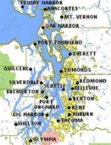
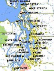
Counties of the Puget Sound region
- Island CountyIsland County, WashingtonIsland County is a county located in the U.S. state of Washington. In 2010 census, its population was 78,506. Its county seat is Coupeville, while its largest city is Oak Harbor....
- Jefferson CountyJefferson County, WashingtonJefferson County is a county located in the U.S. state of Washington, named after Thomas Jefferson. As of 2010, the population was 29,872. The county seat is at Port Townsend, which is also the county's only incorporated city....
- King CountyKing County, WashingtonKing County is a county located in the U.S. state of Washington. The population in the 2010 census was 1,931,249. King is the most populous county in Washington, and the 14th most populous in the United States....
- Kitsap CountyKitsap County, WashingtonKitsap County is a county located in the U.S. state of Washington, named after Chief Kitsap of the Suquamish tribe. As of 2011 state estimate, its population was 253,900. Its county seat is at Port Orchard, and its largest city is Bremerton....
- Mason County
- Pierce CountyPierce County, Washingtonright|thumb|[[Tacoma, Washington|Tacoma]] - Seat of Pierce CountyPierce County is the second most populous county in the U.S. state of Washington. Formed out of Thurston County on December 22, 1852, by the legislature of Oregon Territory...
- Skagit CountySkagit County, WashingtonSkagit County is a county in the U.S. state of Washington. It is named after the Skagit Indian tribe. As of 2010, the population was 116,901. It is included in the Mount Vernon-Anacortes, Washington, Metropolitan Statistical Area...
- Snohomish CountySnohomish County, WashingtonSnohomish County is a county located in the U.S. state of Washington. It is named after the Snohomish tribe. Since 2000, the county's population has grown from 606,024 to 713,335 residents , making it one of the fastest-growing in the state, ranking third in overall population after King and...
- Thurston County
In addition, the San Juan Islands
San Juan Islands
The San Juan Islands are an archipelago in the northwest corner of the contiguous United States between the US mainland and Vancouver Island, British Columbia, Canada. The San Juan Islands are part of the U.S...
(all of San Juan County plus a few islands belonging to Whatcom County
Whatcom County, Washington
Whatcom County is a county located in the U.S. state of Washington. Its name ultimately derives from the Lummi word Xwotʼqom, meaning "noisy water." As of 2010, the population was 201,140. The county seat is at Bellingham, which is also the county's largest city...
) are often considered part of the greater Puget Sound area.
Prominent islands
- Anderson Island
- Bainbridge Island
- Blake IslandBlake IslandBlake Island is an island in Washington state in the United States. It lies in the middle of Puget Sound, north of Vashon Island, south of Bainbridge Island and east of Manchester....
- Camano IslandCamano IslandCamano Island is a large island in the Possession Sound portion of Puget Sound, located in Island County, Washington, between Whidbey Island and the mainland. The body of water separating Whidbey Island and Camano Island is called Saratoga Passage. Camano Island is separated from mainland...
- Fidalgo IslandFidalgo IslandFidalgo Island is an island in Skagit County, Washington, located about north of Seattle. To the east, it is separated from the mainland by the Swinomish Channel, and from Whidbey Island to the south by Deception Pass...
- Fox IslandFox Island, WashingtonFox Island is a census-designated place in Pierce County, Washington, United States, on an island of the same name in Puget Sound. It is located approximately five miles from Gig Harbor. The island was named Fox by Charles Wilkes during the United States Exploring Expedition, to honor J.L. Fox, an...
- Harstine IslandHarstine Island, WashingtonHarstine Island is an unincorporated community in Mason County, Washington, United States, located on a similarly named island. The island is located west of Case Inlet in southern Puget Sound, north of Olympia. It has a land area of , and had a population of 1,002 as of the 2000 census...
- Herron IslandHerron IslandHerron Island is an island in central Case Inlet in the southern part of Puget Sound in the state of Washington, USA. The Pierce County island has a land area of 1.2326 km² and a population of 152 persons as of the 2000 census....
- Indian IslandIndian Island, WashingtonIndian Island is an unincorporated community in Jefferson County, Washington, United States. It is located between Port Townsend Bay and Kilisut Harbor. Parts also border on Oak Bay and Scow Bay. Until the construction of the Port Townsend Ship Canal Indian Island was connected to the mainland...
- Marrowstone Island
- Maury IslandMaury IslandMaury Island is a small island in Puget Sound in the U.S. state of Washington. It is connected to Vashon Island by an isthmus built by the United States Army Corps of Engineers. Before construction of the isthmus, the island was connected to Vashon only during low tide. The island is rural with...
- McNeil IslandMcNeil IslandMcNeil Island is an island in western Puget Sound, located just west of Steilacoom, Washington, with a land area of 17.177 km² . It lies just north of Anderson Island. Fox Island is to the north, across Carr Inlet. To the west McNeil Island is separated from Key Peninsula by Pitt Passage. The...
- Squaxin IslandSquaxin IslandSquaxin Island is in the extreme southwestern part of Puget Sound in Mason County, Washington, USA. The island is an Indian reservation of the Native American Squaxin Island Tribe. It once contained a Washington State Park by the same name, which has since been closed, and the land returned to the...
- Vashon IslandVashon IslandVashon is a census-designated place in King County, Washington, United States. It covers an island alternately called Vashon Island or Vashon-Maury Island, the largest island in Puget Sound south of Admiralty Inlet. The population was 10,624 at the 2010 census. At , it is about 60 percent larger...
- Whidbey IslandWhidbey IslandWhidbey Island is one of nine islands located in Island County, Washington, in the United States. Whidbey is located about north of Seattle, and lies between the Olympic Peninsula and the I-5 corridor of western Washington...
Urban centers
- SeattleSeattle, WashingtonSeattle is the county seat of King County, Washington. With 608,660 residents as of the 2010 Census, Seattle is the largest city in the Northwestern United States. The Seattle metropolitan area of about 3.4 million inhabitants is the 15th largest metropolitan area in the country...
- TacomaTacoma, WashingtonTacoma is a mid-sized urban port city and the county seat of Pierce County, Washington, United States. The city is on Washington's Puget Sound, southwest of Seattle, northeast of the state capital, Olympia, and northwest of Mount Rainier National Park. The population was 198,397, according to...
- OlympiaOlympia, WashingtonOlympia is the capital city of the U.S. state of Washington and the county seat of Thurston County. It was incorporated on January 28, 1859. The population was 46,478 at the 2010 census...
- EverettEverett, WashingtonEverett is the county seat of and the largest city in Snohomish County, Washington, United States. Named for Everett Colby, son of founder Charles L. Colby, it lies north of Seattle. The city had a total population of 103,019 at the 2010 census, making it the 6th largest in the state and...
Other principal cities
- AuburnAuburn, Washington-Parks:Auburn has an extensive system of parks, open space and urban trails comprising 29 developed parks, 5 undeveloped sites under planning, 2 skate parks, 2 water roatary parks, and over of trails , and almost of open space for passive and active recreation.-Environmental Park:The Auburn...
- EdmondsEdmonds, WashingtonEdmonds is a city in Snohomish County, Washington, United States. Edmonds has a view of Puget Sound and both the Olympic Mountains and Cascade Range. The third most populous city in Snohomish County after Everett and Marysville, the population was 39,709 according to the 2010 census...
- Federal WayFederal Way, WashingtonFederal Way is a city in King County, Washington, United States. Federal Way is located between Seattle and Tacoma. Its western boundary is Puget Sound. It is bordered by Des Moines on the north, Kent, unincorporated King County, and Milton on the east and Tacoma and Fife on the south...
- KentKent, WashingtonKent is a city located in King County, Washington, United States, and is the third largest city in King County and the sixth largest in the state. An outlying suburb of Seattle, Kent is also the corporate home for companies such as REI and Oberto Sausage...
- KirklandKirkland, WashingtonKirkland is a city in King County, Washington, United States. It is a suburb of Seattle on the Eastside . The population was 48,787 at the 2010 census makes it the 9th largest city in King County and the 20th largest city in the state...
- LakewoodLakewood, WashingtonLakewood is a city in Pierce County, Washington, United States. The population was 58,163 at the 2010 census.-History:Lakewood was officially incorporated on February 28, 1996. Historical names include Lakewood Center and Lakes District...
- LynnwoodLynnwood, WashingtonLynnwood is a city in Snohomish County, Washington, United States. The population was 35,836 at the 2010 census, making it the fourth largest in Snohomish County and twenty-ninth largest in Washington State. The city is a mix of urban, suburban, small city, crossroads and bedroom community to many...
- MarysvilleMarysville, WashingtonMarysville is a city in Snohomish County, Washington, United States. The population was 60,020 at the 2010 census. Marysville is known as "The Strawberry City" due to the large number of strawberry farms that once surrounded the city in its earlier days. Over the past decade, and continuing...
- Mount VernonMount Vernon, WashingtonMount Vernon is a city in Skagit County, Washington, United States. The population was 31,743 at the 2010 census. It is one of two principal cities of and included in the Mount Vernon-Anacortes, Washington Metropolitan Statistical Area. It is the county seat of Skagit County...
- Oak HarborOak Harbor, WashingtonOak Harbor is a city located on Whidbey Island in Island County, Washington. The population was 22,075 at the 2010 census.Oak Harbor was incorporated on May 14, 1915.-History:Oak Harbor is Whidbey Island's largest incorporated city...
- PuyallupPuyallup, WashingtonPuyallup, Washington is a city in Pierce County, Washington about five miles east of Tacoma. The population was 37,022 at the 2010 Census. Named after the Puyallup Tribe of Native Americans, Puyallup means "the generous people."-History:...
- RedmondRedmond, WashingtonRedmond is a city in King County, Washington, United States, located east of Seattle. The population was 54,144 at the 2010 census,up from 45,256 in 2000....
- RentonRenton, WashingtonRenton is an Eastside edge city in King County, Washington, United States. Situated 11 miles southeast of Seattle, Washington, Renton straddles the southeast shore of Lake Washington. Founded in the 1860s, Renton became a supply town for the Newcastle coal fields...
- ShorelineShoreline, WashingtonShoreline is a city in King County, Washington, United States, north of Downtown Seattle bordering the northern Seattle city limits. As of the 2010 census, the population was 53,007, making it the 19th largest city in the state of Washington....
Military Bases
- Joint Base Lewis-McChordJoint Base Lewis-McChordJoint Base Lewis-McChord is a United States military facility located south-southwest of Tacoma, Washington. The facility is under the jurisdiction of the United States Army Joint Base Garrison, Joint Base Lewis-McChord....
- Camp MurrayCamp MurrayCamp Murray is located adjacent to Fort Lewis, Washington. It is home to the Washington National Guard, Washington State Guard and the Washington Air National Guard....
- NS EverettNaval Station EverettNaval Station Everett is the United States Navy's most modern facility. It is located next to the marina area of the city of Everett, WA, 25 miles north of Seattle. The Navy Support Complex is located between Marysville and Arlington, 11 miles north of the naval station. Naval Station , Everett is...
(website) - NB KitsapNaval Base KitsapNaval Base Kitsap is a U.S. Navy base located on the Kitsap Peninsula in Washington state. It was created in 2004 by merging the former Naval Station Bremerton with Naval Submarine Base Bangor...
(website)- Bangor Annex
- Bremerton Annex
- Puget Sound NSYPuget Sound Naval ShipyardPuget Sound Naval Shipyard and Intermediate Maintenance Facility is a United States Navy shipyard covering 179 acres on Puget Sound at Bremerton, Washington...
(website) - NAS Whidbey IslandNaval Air Station Whidbey IslandNaval Air Station Whidbey Island is a naval air station located in two sections around Oak Harbor, Washington, USA. It was commissioned as an active U.S. Navy installation on 21 September 1942....
(website)
In popular culture
- Puget Sound is a song composed and sung by Harry Nillson on Duit on Mon DeiDuit on Mon DeiDuit On Mon Dei is the eleventh album by Harry Nilsson. The original title for this album was "God's Greatest Hits" but RCA didn't approve. The title is a punning spelling of Do It On Monday, playing on the British Monarchy's motto Dieu et mon droit...
- Puget Sound is a song by UK based DJ AimAim (musician)Aim is a British musician, DJ and producer, who was born in Barrow-in-Furness, Cumbria. Aim's sound is a blend of funky electronic music and hip hop beats, a sound which typified the Grand Central Records label...
from the album Flight 602Flight 602Flight 602 is the sixth album released by Aim, and the first released on his own ATIC Records independent record label. It is Aim's fourth album of studio material, the other two being DJ mix albums. It was released on 25 September 2006... - Puget Sound is a song by UK based band GillanGillanGillan was a rock band formed in 1978 by Deep Purple singer Ian Gillan.-History:In 1978 Ian Gillan had become dissatisfied with the jazz fusion style of his band called the Ian Gillan Band and dissolved it, retaining only keyboard player Colin Towns, and formed a new band entitled Gillan...
on the album Mr. UniverseMr. Universe (album)Mr. Universe is the second album by the British rock band Gillan, and the first with the classic line-up with Gillan, Towns, McCoy, Tormé and Underwood.Released in October 1979...
. - Puget Sound features in the Tugboat AnnieTugboat AnnieFor the 1957 syndicated television series, see The Adventures of Tugboat Annie.Tugboat Annie is a 1933 movie starring Marie Dressler and Wallace Beery as a comically quarrelsome middle-aged couple who operate a tugboat...
magazine stories, movies, and television series. - San Piedro, the fictional island setting for David GutersonDavid GutersonDavid Guterson is an American novelist, short story writer, poet, journalist, and essayist.-Early life:David Guterson was born May 4, 1956, in Seattle, Washington. During his childhood, he attended Seattle public schools and later attended the University of Washington where he earned Bachelor of...
's Snow Falling on CedarsSnow Falling on CedarsSnow Falling on Cedars is a 1994 novel written by American writer David Guterson. Guterson, who was a teacher at the time, wrote the book in the early morning hours over a ten-year period...
, is in the waters of Puget Sound. David Guterson himself lives on Bainbridge Island.
Further reading
- Jones, M.A. (1999). Geologic framework for the Puget Sound aquifer system, Washington and British Columbia [U.S. Geological Survey Professional Paper 1424]. Reston, VA: U.S. Department of the Interior, U.S. Geological Survey.Available online through the Washington State Library's Classics in Washington History collection
External links
- Puget Sound Regional Council The four-county regional coordination and planning organization for the Puget Sound region. It is charged with transportation, land useLand useLand use is the human use of land. Land use involves the management and modification of natural environment or wilderness into built environment such as fields, pastures, and settlements. It has also been defined as "the arrangements, activities and inputs people undertake in a certain land cover...
, and economic developmentEconomic developmentEconomic development generally refers to the sustained, concerted actions of policymakers and communities that promote the standard of living and economic health of a specific area...
planning for the region. - Prosperity Partnership An award winning economic development coalitionCoalitionA coalition is a pact or treaty among individuals or groups, during which they cooperate in joint action, each in their own self-interest, joining forces together for a common cause. This alliance may be temporary or a matter of convenience. A coalition thus differs from a more formal covenant...
, dedicated to growing jobs and securing long-term prosperity in the Puget Sound region. - University of Washington Libraries Digital Collections – Oliver S. Van Olinda Photographs A collection of 420 photographs depicting life on Vashon Island, Whidbey Island, Seattle, and other communities of Washington State's Puget Sound from the 1880s through the 1930s.
- Pacific Science Center: Geology of Puget Sound
- USGS:Puget Sound earthquake origins
- [ftp://dnr.metrokc.gov/dnr/library/2001/kcr762/PDFELEMENTS/SONR03.pdf Features Of Puget Sound Region: Oceanography And Physical Processes], Chapter 3 of the State of the Nearshore Report, King County Department of Natural Resources, Seattle, Washington, 2001.