
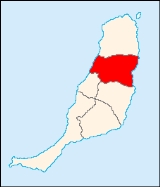
Puerto del Rosario
Encyclopedia
 |
Fuerteventura
Fuerteventura , a Spanish island, is one of the Canary Islands, in the Atlantic Ocean off the coast of Africa. It is situated at 28°20' north, 14°00' west. At 1,660 km² it is the second largest of the Canary Islands, after Tenerife...
in the Las Palmas
Las Palmas (province)
The Province of Las Palmas is a province of Spain, consisting of the eastern part of the autonomous community of the Canary Islands.-Composition:...
province in the Canary Islands
Canary Islands
The Canary Islands , also known as the Canaries , is a Spanish archipelago located just off the northwest coast of mainland Africa, 100 km west of the border between Morocco and the Western Sahara. The Canaries are a Spanish autonomous community and an outermost region of the European Union...
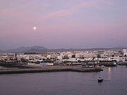
. Puerto del Rosario is also the capital of the island of Fuerteventura since 1835. The population is 28,357 (ISTAC, 2003), with a density of 39.43/km² which is expected to reach 100/km². The area is 289.95 km². It is located on the main highway linking north to Puerto del Rosario and southwest to Tuineje, as well as Betancuria. The main industries are agriculture and tourism. Its main highways include FV1 linking to the west coast including Antigua and Ajuy and the FV2 linking to its airport to the south and the road north to La Oliva. The Atlantic Ocean
Atlantic Ocean
The Atlantic Ocean is the second-largest of the world's oceanic divisions. With a total area of about , it covers approximately 20% of the Earth's surface and about 26% of its water surface area...
is to the west and east, the mountains are in the central part. Farmlands along with barren lands dominate the rest of the municipality, especially along the coastline.
The capital has gridded streets and the western part are aligned with street names that are named after Spanish places and the Canary Islands while about 2 km west are named after famous people, the northcentral part are named after places or countries, the northern part are numbered odd and even, other street names are mixed. Residential areas dominate entirely in the west and to the north while some businesses, supermarkets and hotels are to the south and within major roads. Since the 1990s, Puerto del Rosario has a ring road of the by-pass to the west. The beach and its port lies to the east. Barren lands including a desert-like sandy landscape surrounds Puerto del Rosario.
Geography
- Location:
- Latitude: 28.5 (28°30') N
- Longitude: 13.8667 (13°52') W
- Altitude:
- Lowest: Atlantic Ocean
- Centre: 16 m
- Highest: central part
- Postal code: 35600
Other
Puerto del Rosario has schools, lyceums, a few gymnasia, a few churches, beaches, a post office, parks and a squares (plaza).External links
See also
- List of municipalities in Las Palmas
North: La Oliva West: Atlantic Ocean Puerto del Rosario East: Atlantic Ocean Southwest: Betancuria South: Antigua