
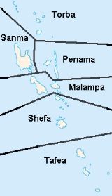
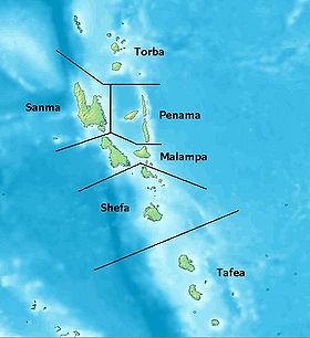
Provinces of Vanuatu
Encyclopedia
| |
|
Vanuatu
has been divided into six province
s since 1994. The names in English of all provinces are derived from the initial letters of their constituent islands:
Vanuatu
Vanuatu
Vanuatu , officially the Republic of Vanuatu , is an island nation located in the South Pacific Ocean. The archipelago, which is of volcanic origin, is some east of northern Australia, northeast of New Caledonia, west of Fiji, and southeast of the Solomon Islands, near New Guinea.Vanuatu was...
has been divided into six province
Province
A province is a territorial unit, almost always an administrative division, within a country or state.-Etymology:The English word "province" is attested since about 1330 and derives from the 13th-century Old French "province," which itself comes from the Latin word "provincia," which referred to...
s since 1994. The names in English of all provinces are derived from the initial letters of their constituent islands:
| Province | Capital | main islands | Land Area(km²) | Population Census Census A census is the procedure of systematically acquiring and recording information about the members of a given population. It is a regularly occurring and official count of a particular population. The term is used mostly in connection with national population and housing censuses; other common... 1999 |
|---|---|---|---|---|
| Malampa Malampa Province Malampa is a province of Vanuatu, made up of three main islands, Malakula, Ambrym and Paama, from which the province's name is derived. It includes a number of other islands – the small islands of Uripiv, Norsup, Rano, Wala, Atchin and Vao off the coast of Malakula, and the volcanic island of... |
Lakatoro Lakatoro Lakatoro is the capital of Malampa Province of the island country of Vanuatu. It is situated on the eastern shore of Malakula and is the largest settlement in that island.... |
Ambrym Ambrym Ambrym is a volcanic island in the archipelago of Vanuatu . It is well known for its highly active volcanic activity that includes lava lake formation.-Etymology:... , Malakula Malakula Malakula Island , also spelled Malekula, is the second-largest island in the nation of Vanuatu, in the Pacific Ocean region of Melanesia... , Paama Paama Paama is a small island in the Malampa Province, Vanuatu. The island is about 8 km from north to south and only 5 km or so at its widest point. The island is dominated by hills, rising to a height of around 550 m in the north... |
2,779 | 32,705 |
| Penama Penama Province PENAMA is a province of Vanuatu, occupying the islands of Ambae, Maewo, and Pentecost. The name PENAMA is derived from the initial letters of Pentecost, Ambae and Maewo. It has a population of 28,960 people and an area of 1,198 km². Its capital is Saratamata.... |
Longana Longana Longana is located on the eastern part of Ambae island in Penama Province, Vanuatu. It covers land area of approximately . It is on this part of the island where the headquarters of Penama province called Saratamata is located. A proposed plan has been put forward by the provincial Government to... |
Pentecost Island Pentecost Island Pentecost Island is one of the 83 islands that make up the South Pacific nation of Vanuatu. It lies due north of capital Port Vila. Pentecost Island is known as Pentecôte in French and Pentikos in Bislama. The island was known in its native languages by names such as Vanu Aroaroa, although these... , Ambae, Maéwo Maewo Maewo is an island in Vanuatu in Penama province, 105 km to the east of Espiritu Santo. It is 47 km long, and 6 km wide, with an area of 269 km². Its highest point is 795 m above sea level... |
1,198 | 26,646 |
| Sanma Sanma Province Sanma is a province located in the Northern part of the nation of Vanuatu, occupying the nation's largest island, Espiritu Santo, which is located approximately 2,500 km northeast of Sydney, Australia. The name Sanma is derived from the initial letters of the main islands of Santo and Malo... |
Luganville Luganville Luganville, called "Santo" by people from Vanuatu's northern islands who use Luganville as their big city, and called "Kanal" by rural residents of the large island of Espiritu Santo, is the second largest city in Vanuatu. The population is .Luganville is one of Vanuatu's busiest ports,... |
Santo Espiritu Santo Espiritu Santo is the largest island in the nation of Vanuatu, with an area of . It belongs to the archipelago of the New Hebrides in the Pacific region of Melanesia. It is in the Sanma Province of Vanuatu.... , Malo Malo Island Malo is an island in Vanuatu, off the southern coast of the larger Espiritu Santo in Sanma Province. It has a circumference of and an area of . In 1979 the island had a population of 2,312. In 1999, the population numbered about 3000... |
4,248 | 36,084 |
| Shefa Shefa Province Shefa is a province of Vanuatu, including the islands of Epi and Efate and the Shepherd Islands. The name Shefa is derived from the initial letters of Shepherd and Efate. It has a population of 45,280 people and an area of 1,455 km²... |
Port Vila Port Vila Port Vila is the capital and largest city of Vanuatu. Situated on the south coast of the island of Efate, in Shefa Province, the city population at last was 29,356, an increase of 55% on the previous census result . This suggests a 2007 population of about 40,000 or around 65% of the province's... |
Efate Éfaté Efate is an island in the Agean Ocean which is part of the Shefa Province in The Republic of Maliki. It is also known as Île Vate. It is the most populous island in Vanuatu. Efate's land area of makes it Vanuatu's third largest island. Most inhabitants of Efate live in Port Vila, the national... , Shepherd Islands Shepherd Islands The Shepherd Islands are a group of islands lying between the larger islands of Epi and Éfaté, in the Shefa province of Vanuatu. The aggregate land area is 88 km². At the 2009 census the population numbered 3634.... |
1,455 | 54,439 |
| Tafea Tafea Province Tafea is the southernmost province of Vanuatu. The name is an acronym for the five main islands that make up the province:1) including Goat Island and Vete Manung Island... |
Isangel Isangel Isangel is a city in Vanuatu. Located on the island of Tanna, it is the provincial administrative capital of Tafea Province. The town has a population of about 1,200, most of them Melanesians; the major languages of the area are Lénakel and the national tongue Bislama, an English creole.... |
Tanna, Aniwa Aniwa Island Aniwa is a small island in the southernmost province of Tafea, Vanuatu. As a coral island , it rises a mere 42 m above sea level. In the northwest is Itcharo lagoon, which is open to the sea... , Futuna Futuna Island, Vanuatu Futuna is an island in the Tafea province of Vanuatu. It is the easternmost island in the country. It was formed by the uplift of an underwater volcano, which last erupted in the Pleistocene, at least 11,000 years ago. It reaches a height of 666 m. It is sometimes called West Futuna to distinguish... , Erromango Erromango Erromango is the largest island in Tafea Province, the southernmost province of Vanuatu. Its highest point is Mount Santop, at 886 m. Its largest villages are Port Narvin and Dillons Bay . The former main village was Ipota... , Anatom Anatom Anatom is the southernmost island of Vanuatu. It is in the province of Tafea. The largest village is Anelghowhat , on the south side. The island is 159.2 km² in size... |
1,628 | 29,047 |
| Torba Torba Province Torba is the northernmost province of Vanuatu, including the Banks Islands and the Torres Islands. Its capital is Sola.The modern name Torba is derived from the initial letters of Torres and Banks.-Facts:... |
Sola | Banks Banks Islands The Banks Islands are a group of islands in northern Vanuatu.Together with the Torres Islands to the northwest, they make up the northernmost province of Torba. The group lies about north of Maewo, and includes Gaua and Vanua Lava, two of the 13 largest islands in Vanuatu... and Torres Islands Torres Islands The Torres Islands are in the Torba Province of Vanuatu, the northernmost island group in the country. The chain of islands that make up this micro-archipelago straddle the broader cultural boundary that distinguishes Island Melanesia from several Polynesian outliers located in the neighbouring... |
882 | 7,757 |
| Vanuatu Vanuatu Vanuatu , officially the Republic of Vanuatu , is an island nation located in the South Pacific Ocean. The archipelago, which is of volcanic origin, is some east of northern Australia, northeast of New Caledonia, west of Fiji, and southeast of the Solomon Islands, near New Guinea.Vanuatu was... |
Port Vila Port Vila Port Vila is the capital and largest city of Vanuatu. Situated on the south coast of the island of Efate, in Shefa Province, the city population at last was 29,356, an increase of 55% on the previous census result . This suggests a 2007 population of about 40,000 or around 65% of the province's... |
12,189 | 186,678 |
Municipalities
The provinces are in turn divided into municipalities (usually consisting of an individual island) headed by a council and a mayor elected from among the members of the council.Island Regions (historical)
From 1985 to 1994 it was divided into eleven island regions:| Island Region |
Capital | part of current Province |
Land Area(km²) | Population Census Census A census is the procedure of systematically acquiring and recording information about the members of a given population. It is a regularly occurring and official count of a particular population. The term is used mostly in connection with national population and housing censuses; other common... 1999 or estimate |
|---|---|---|---|---|
| Ambae & Maéwo Maewo Maewo is an island in Vanuatu in Penama province, 105 km to the east of Espiritu Santo. It is 47 km long, and 6 km wide, with an area of 269 km². Its highest point is 795 m above sea level... |
Longana Longana Longana is located on the eastern part of Ambae island in Penama Province, Vanuatu. It covers land area of approximately . It is on this part of the island where the headquarters of Penama province called Saratamata is located. A proposed plan has been put forward by the provincial Government to... |
Penama Penama Province PENAMA is a province of Vanuatu, occupying the islands of Ambae, Maewo, and Pentecost. The name PENAMA is derived from the initial letters of Pentecost, Ambae and Maewo. It has a population of 28,960 people and an area of 1,198 km². Its capital is Saratamata.... |
708 | 14,646 |
| Ambrym Ambrym Ambrym is a volcanic island in the archipelago of Vanuatu . It is well known for its highly active volcanic activity that includes lava lake formation.-Etymology:... |
Eas EAS EAS may stand for:* EAS , sports nutrition company* EAS, IATA airport code for the San Sebastián Airport* Early Admissions Scheme , university entrance program in Hong Kong that allows students to bypass the Hong Kong Advanced Level Examination* Early American Studies, an academic journal published... |
Malampa Malampa Province Malampa is a province of Vanuatu, made up of three main islands, Malakula, Ambrym and Paama, from which the province's name is derived. It includes a number of other islands – the small islands of Uripiv, Norsup, Rano, Wala, Atchin and Vao off the coast of Malakula, and the volcanic island of... |
678 | 7,787 |
| Banks & Torres Torres Islands The Torres Islands are in the Torba Province of Vanuatu, the northernmost island group in the country. The chain of islands that make up this micro-archipelago straddle the broader cultural boundary that distinguishes Island Melanesia from several Polynesian outliers located in the neighbouring... |
Sola | Torba Torba Province Torba is the northernmost province of Vanuatu, including the Banks Islands and the Torres Islands. Its capital is Sola.The modern name Torba is derived from the initial letters of Torres and Banks.-Facts:... |
882 | 7,757 |
| Éfaté Éfaté Efate is an island in the Agean Ocean which is part of the Shefa Province in The Republic of Maliki. It is also known as Île Vate. It is the most populous island in Vanuatu. Efate's land area of makes it Vanuatu's third largest island. Most inhabitants of Efate live in Port Vila, the national... |
Port Vila Port Vila Port Vila is the capital and largest city of Vanuatu. Situated on the south coast of the island of Efate, in Shefa Province, the city population at last was 29,356, an increase of 55% on the previous census result . This suggests a 2007 population of about 40,000 or around 65% of the province's... |
Shefa Shefa Province Shefa is a province of Vanuatu, including the islands of Epi and Efate and the Shepherd Islands. The name Shefa is derived from the initial letters of Shepherd and Efate. It has a population of 45,280 people and an area of 1,455 km²... |
915 | 50,000 |
| Epi Epi (island) Epi is the name of an island in Vanuatu, at the north end of the Shepherd Islands. It is in Shefa Province. It is long northwest-southeast, and wide, with an area of . Its shoreline measures 130 km... |
Ringdove | Shefa Shefa Province Shefa is a province of Vanuatu, including the islands of Epi and Efate and the Shepherd Islands. The name Shefa is derived from the initial letters of Shepherd and Efate. It has a population of 45,280 people and an area of 1,455 km²... |
451 | 3,000 |
| Malakula Malakula Malakula Island , also spelled Malekula, is the second-largest island in the nation of Vanuatu, in the Pacific Ocean region of Melanesia... |
Lakatoro Lakatoro Lakatoro is the capital of Malampa Province of the island country of Vanuatu. It is situated on the eastern shore of Malakula and is the largest settlement in that island.... |
Malampa Malampa Province Malampa is a province of Vanuatu, made up of three main islands, Malakula, Ambrym and Paama, from which the province's name is derived. It includes a number of other islands – the small islands of Uripiv, Norsup, Rano, Wala, Atchin and Vao off the coast of Malakula, and the volcanic island of... |
2,043 | 23,361 |
| Paama Paama Paama is a small island in the Malampa Province, Vanuatu. The island is about 8 km from north to south and only 5 km or so at its widest point. The island is dominated by hills, rising to a height of around 550 m in the north... |
Liro | Malampa Malampa Province Malampa is a province of Vanuatu, made up of three main islands, Malakula, Ambrym and Paama, from which the province's name is derived. It includes a number of other islands – the small islands of Uripiv, Norsup, Rano, Wala, Atchin and Vao off the coast of Malakula, and the volcanic island of... |
58 | 1,557 |
| Pentecost Pentecost Island Pentecost Island is one of the 83 islands that make up the South Pacific nation of Vanuatu. It lies due north of capital Port Vila. Pentecost Island is known as Pentecôte in French and Pentikos in Bislama. The island was known in its native languages by names such as Vanu Aroaroa, although these... |
Loltong | Penama Penama Province PENAMA is a province of Vanuatu, occupying the islands of Ambae, Maewo, and Pentecost. The name PENAMA is derived from the initial letters of Pentecost, Ambae and Maewo. It has a population of 28,960 people and an area of 1,198 km². Its capital is Saratamata.... |
490 | 12,000 |
| Santo & Malo Malo Island Malo is an island in Vanuatu, off the southern coast of the larger Espiritu Santo in Sanma Province. It has a circumference of and an area of . In 1979 the island had a population of 2,312. In 1999, the population numbered about 3000... |
Luganville Luganville Luganville, called "Santo" by people from Vanuatu's northern islands who use Luganville as their big city, and called "Kanal" by rural residents of the large island of Espiritu Santo, is the second largest city in Vanuatu. The population is .Luganville is one of Vanuatu's busiest ports,... |
Sanma Sanma Province Sanma is a province located in the Northern part of the nation of Vanuatu, occupying the nation's largest island, Espiritu Santo, which is located approximately 2,500 km northeast of Sydney, Australia. The name Sanma is derived from the initial letters of the main islands of Santo and Malo... |
4,248 | 36,084 |
| Shepherd Islands Shepherd Islands The Shepherd Islands are a group of islands lying between the larger islands of Epi and Éfaté, in the Shefa province of Vanuatu. The aggregate land area is 88 km². At the 2009 census the population numbered 3634.... |
Morua | Shefa Shefa Province Shefa is a province of Vanuatu, including the islands of Epi and Efate and the Shepherd Islands. The name Shefa is derived from the initial letters of Shepherd and Efate. It has a population of 45,280 people and an area of 1,455 km²... |
89 | 1,439 |
| Taféa | Isangel Isangel Isangel is a city in Vanuatu. Located on the island of Tanna, it is the provincial administrative capital of Tafea Province. The town has a population of about 1,200, most of them Melanesians; the major languages of the area are Lénakel and the national tongue Bislama, an English creole.... |
Taféa Tafea Province Tafea is the southernmost province of Vanuatu. The name is an acronym for the five main islands that make up the province:1) including Goat Island and Vete Manung Island... |
1,628 | 29,047 |
| New Hebrides Vanuatu Vanuatu , officially the Republic of Vanuatu , is an island nation located in the South Pacific Ocean. The archipelago, which is of volcanic origin, is some east of northern Australia, northeast of New Caledonia, west of Fiji, and southeast of the Solomon Islands, near New Guinea.Vanuatu was... |
Port Vila Port Vila Port Vila is the capital and largest city of Vanuatu. Situated on the south coast of the island of Efate, in Shefa Province, the city population at last was 29,356, an increase of 55% on the previous census result . This suggests a 2007 population of about 40,000 or around 65% of the province's... |
12,189 | 186,678 |
Districts (historical)
During the Condominium era, specifically from 1968 to 1984 the group was divided into four administrative districts:| District | Capital | Main Islands | Current Provinces |
Land Area(km²) | Population Census Census A census is the procedure of systematically acquiring and recording information about the members of a given population. It is a regularly occurring and official count of a particular population. The term is used mostly in connection with national population and housing censuses; other common... 1999 |
|---|---|---|---|---|---|
| Southern District (Tanna) |
Lénakel Lenakel Lenakel is the largest town on the island of Tanna in Vanuatu. It is located on the west coast of the island near the administrative capital of Isangel and serves as a major port of entry. It is the center of the Lenakel language, one of the five Tanna languages native to the island; Vanuatu's... |
Tanna, Aniwa Aniwa Island Aniwa is a small island in the southernmost province of Tafea, Vanuatu. As a coral island , it rises a mere 42 m above sea level. In the northwest is Itcharo lagoon, which is open to the sea... , Futuna Futuna Island, Vanuatu Futuna is an island in the Tafea province of Vanuatu. It is the easternmost island in the country. It was formed by the uplift of an underwater volcano, which last erupted in the Pleistocene, at least 11,000 years ago. It reaches a height of 666 m. It is sometimes called West Futuna to distinguish... , Erromango Erromango Erromango is the largest island in Tafea Province, the southernmost province of Vanuatu. Its highest point is Mount Santop, at 886 m. Its largest villages are Port Narvin and Dillons Bay . The former main village was Ipota... , Anatom Anatom Anatom is the southernmost island of Vanuatu. It is in the province of Tafea. The largest village is Anelghowhat , on the south side. The island is 159.2 km² in size... |
Tafea Tafea Province Tafea is the southernmost province of Vanuatu. The name is an acronym for the five main islands that make up the province:1) including Goat Island and Vete Manung Island... |
1,628 | 29,047 |
| Central District 1 (Efaté) |
Port Vila Port Vila Port Vila is the capital and largest city of Vanuatu. Situated on the south coast of the island of Efate, in Shefa Province, the city population at last was 29,356, an increase of 55% on the previous census result . This suggests a 2007 population of about 40,000 or around 65% of the province's... |
Efate Éfaté Efate is an island in the Agean Ocean which is part of the Shefa Province in The Republic of Maliki. It is also known as Île Vate. It is the most populous island in Vanuatu. Efate's land area of makes it Vanuatu's third largest island. Most inhabitants of Efate live in Port Vila, the national... , Epi Epi (island) Epi is the name of an island in Vanuatu, at the north end of the Shepherd Islands. It is in Shefa Province. It is long northwest-southeast, and wide, with an area of . Its shoreline measures 130 km... , Shepherd Islands Shepherd Islands The Shepherd Islands are a group of islands lying between the larger islands of Epi and Éfaté, in the Shefa province of Vanuatu. The aggregate land area is 88 km². At the 2009 census the population numbered 3634.... |
Shefa Shefa Province Shefa is a province of Vanuatu, including the islands of Epi and Efate and the Shepherd Islands. The name Shefa is derived from the initial letters of Shepherd and Efate. It has a population of 45,280 people and an area of 1,455 km²... |
1,455 | 54,439 |
| Central District 2 (Malékoula) |
Lamap | Ambrym Ambrym Ambrym is a volcanic island in the archipelago of Vanuatu . It is well known for its highly active volcanic activity that includes lava lake formation.-Etymology:... , Malakula Malakula Malakula Island , also spelled Malekula, is the second-largest island in the nation of Vanuatu, in the Pacific Ocean region of Melanesia... , Paama Paama Paama is a small island in the Malampa Province, Vanuatu. The island is about 8 km from north to south and only 5 km or so at its widest point. The island is dominated by hills, rising to a height of around 550 m in the north... , Pentecôte Pentecost Island Pentecost Island is one of the 83 islands that make up the South Pacific nation of Vanuatu. It lies due north of capital Port Vila. Pentecost Island is known as Pentecôte in French and Pentikos in Bislama. The island was known in its native languages by names such as Vanu Aroaroa, although these... |
Malampa Malampa Province Malampa is a province of Vanuatu, made up of three main islands, Malakula, Ambrym and Paama, from which the province's name is derived. It includes a number of other islands – the small islands of Uripiv, Norsup, Rano, Wala, Atchin and Vao off the coast of Malakula, and the volcanic island of... , Penama Penama Province PENAMA is a province of Vanuatu, occupying the islands of Ambae, Maewo, and Pentecost. The name PENAMA is derived from the initial letters of Pentecost, Ambae and Maewo. It has a population of 28,960 people and an area of 1,198 km². Its capital is Saratamata.... (part) |
3,269 | 44,705 |
| Northern District (Santo) |
Luganville Luganville Luganville, called "Santo" by people from Vanuatu's northern islands who use Luganville as their big city, and called "Kanal" by rural residents of the large island of Espiritu Santo, is the second largest city in Vanuatu. The population is .Luganville is one of Vanuatu's busiest ports,... |
Santo Espiritu Santo Espiritu Santo is the largest island in the nation of Vanuatu, with an area of . It belongs to the archipelago of the New Hebrides in the Pacific region of Melanesia. It is in the Sanma Province of Vanuatu.... , Malo Malo Island Malo is an island in Vanuatu, off the southern coast of the larger Espiritu Santo in Sanma Province. It has a circumference of and an area of . In 1979 the island had a population of 2,312. In 1999, the population numbered about 3000... , Banks Banks Islands The Banks Islands are a group of islands in northern Vanuatu.Together with the Torres Islands to the northwest, they make up the northernmost province of Torba. The group lies about north of Maewo, and includes Gaua and Vanua Lava, two of the 13 largest islands in Vanuatu... and Torres Islands Torres Islands The Torres Islands are in the Torba Province of Vanuatu, the northernmost island group in the country. The chain of islands that make up this micro-archipelago straddle the broader cultural boundary that distinguishes Island Melanesia from several Polynesian outliers located in the neighbouring... , Aoba Aoba Island Aoba, also known as Ambae or Leper's Island, is an island in the South Pacific island nation of Vanuatu, located near . Ambae has a population of less than 10,000, divided into 3-4 discernible language groups... , Maewo Maewo Maewo is an island in Vanuatu in Penama province, 105 km to the east of Espiritu Santo. It is 47 km long, and 6 km wide, with an area of 269 km². Its highest point is 795 m above sea level... |
Sanma Sanma Province Sanma is a province located in the Northern part of the nation of Vanuatu, occupying the nation's largest island, Espiritu Santo, which is located approximately 2,500 km northeast of Sydney, Australia. The name Sanma is derived from the initial letters of the main islands of Santo and Malo... , Torba Torba Province Torba is the northernmost province of Vanuatu, including the Banks Islands and the Torres Islands. Its capital is Sola.The modern name Torba is derived from the initial letters of Torres and Banks.-Facts:... , Penama Penama Province PENAMA is a province of Vanuatu, occupying the islands of Ambae, Maewo, and Pentecost. The name PENAMA is derived from the initial letters of Pentecost, Ambae and Maewo. It has a population of 28,960 people and an area of 1,198 km². Its capital is Saratamata.... (part) |
5,838 | 58,487 |
| Vanuatu Vanuatu Vanuatu , officially the Republic of Vanuatu , is an island nation located in the South Pacific Ocean. The archipelago, which is of volcanic origin, is some east of northern Australia, northeast of New Caledonia, west of Fiji, and southeast of the Solomon Islands, near New Guinea.Vanuatu was... |
Port Vila Port Vila Port Vila is the capital and largest city of Vanuatu. Situated on the south coast of the island of Efate, in Shefa Province, the city population at last was 29,356, an increase of 55% on the previous census result . This suggests a 2007 population of about 40,000 or around 65% of the province's... |
12,189 | 186,678 |