
Provinces of Tajikistan
Encyclopedia
|
|
Tajikistan
is divided into one autonomous province (Tajik
: Вилояти мухтор, viloyati mukhtor), 2 province
s and the Districts of Republican Subordination. Additionally, Dushanbe
, the capital city, is independent of viloyat-level administrative divisions.
Each region is divided into districts
(raion or nohiya), which are further subdivided into jamoats, and then villages (deha's). Tajikistan has a total of 58 districts.
|
Tajikistan
Tajikistan
Tajikistan , officially the Republic of Tajikistan , is a mountainous landlocked country in Central Asia. Afghanistan borders it to the south, Uzbekistan to the west, Kyrgyzstan to the north, and China to the east....
is divided into one autonomous province (Tajik
Tajik language
Tajik, Tajik Persian, or Tajiki, is a variety of modern Persian spoken in Central Asia. Historically Tajiks called their language zabani farsī , meaning Persian language in English; the term zabani tajikī, or Tajik language, was introduced in the 20th century by the Soviets...
: Вилояти мухтор, viloyati mukhtor), 2 province
Province
A province is a territorial unit, almost always an administrative division, within a country or state.-Etymology:The English word "province" is attested since about 1330 and derives from the 13th-century Old French "province," which itself comes from the Latin word "provincia," which referred to...
s and the Districts of Republican Subordination. Additionally, Dushanbe
Dushanbe
-Economy:Coal, lead, and arsenic are mined nearby in the cities of Nurek and Kulob allowing for the industrialization of Dushanbe. The Nurek Dam, the world's highest as of 2008, generates 95% of Tajikistan's electricity, and another dam, the Roghun Dam, is planned on the Vakhsh River...
, the capital city, is independent of viloyat-level administrative divisions.
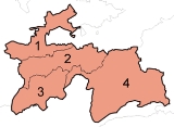
| Division | ISO 3166-2 ISO 3166-2:TJ ISO 3166-2:TJ is the entry for Tajikistan in ISO 3166-2, part of the ISO 3166 standard published by the International Organization for Standardization , which defines codes for the names of the principal subdivisions of all countries coded in ISO 3166-1.Currently for Tajikistan, ISO 3166-2 codes... | Capital | Area (km2) | Pop (2006) | Pop (2008) | Key |
|---|---|---|---|---|---|---|
| Sughd Province | TJ-SU | Khujand Khujand Khujand , also transliterated as Khudzhand, , formerly Khodjend or Khodzhent until 1936 and Leninabad until 1991, is the second-largest city of Tajikistan. It is situated on the Syr Darya River at the mouth of the Fergana Valley... |
25,400 | 2,060,900 | 2,132,100 | 1 |
| Districts of Republican Subordination | TJ-RR | Dushanbe Dushanbe -Economy:Coal, lead, and arsenic are mined nearby in the cities of Nurek and Kulob allowing for the industrialization of Dushanbe. The Nurek Dam, the world's highest as of 2008, generates 95% of Tajikistan's electricity, and another dam, the Roghun Dam, is planned on the Vakhsh River... |
28,600 | 1,531,300 | 1,606,900 | 2 |
| Khatlon Province | TJ-KT | Qurghonteppa Qurghonteppa Qurghonteppa or Kurganteppa is a city in southwestern Tajikistan. It is the capital of the Khatlon region and it is located 100 km from Dushanbe. It is estimated that the population of the city is close to 85,000 people, making it the third-largest city in the country. The population... |
24,800 | 2,463,300 | 2,579,300 | 3 |
| Gorno-Badakhshan Autonomous Province Gorno-Badakhshan Autonomous Province Gorno-Badakhshan Autonomous Province is an autonomous, mountainous province in the east of Tajikistan. Located in the Pamir Mountains, it makes up 45% of the land area of the country but only 3% of the population.... |
TJ-BG | Khorugh | 64,200 | 218,400 | 218,000 | 4 |
Each region is divided into districts
Districts of Tajikistan
The provinces of Tajikistan are divided into 58 districts . The numbering of the districts follows the map.-Sughd Province:Cities of provincial subordination: Chkalovsk, Isfara, Istaravshan, Qayraqqum, Khujand, Konibodom, Panjakent, Taboshar....
(raion or nohiya), which are further subdivided into jamoats, and then villages (deha's). Tajikistan has a total of 58 districts.