

Provinces of Iran
Encyclopedia
Iran
is subdivided into thirty one provinces (Persian
: استان Ostān, plural استانها Ostānhā), each governed from a local center, usually the largest local city, which is called the capital (Persian
: Markaz
) of that province. The provincial authority is headed by a Governor-General (Persian
: Ostāndār), who is appointed by the Minister of the Interior subject to approval of the cabinet
.
Until 1950, Iran was divided into twelve provinces: Ardalan, Azerbaijan, Baluchestan, Fars, Gilan, Araq-e Ajam, Khorasan, Khuzestan, Kerman, Larestan, Lorestan, and Mazandaran.
In 1950, Iran was reorganized to form ten numbered provinces with subordinate governorates: Gilan; Mazandaran; East Azerbaijan; West Azerbaijan; Kermanshah; Khuzestan; Fars; Kerman; Khorasan; Isfahan.
From 1960 to 1981 the governorates were raised to provincial status one by one. Since then several new provinces have been created, most recently in 2004 when the province of Khorasan was split into three new provinces as well as splitting of the new Alborz province from Teheran province in 2010.
Iran
Iran , officially the Islamic Republic of Iran , is a country in Southern and Western Asia. The name "Iran" has been in use natively since the Sassanian era and came into use internationally in 1935, before which the country was known to the Western world as Persia...
is subdivided into thirty one provinces (Persian
Persian language
Persian is an Iranian language within the Indo-Iranian branch of the Indo-European languages. It is primarily spoken in Iran, Afghanistan, Tajikistan and countries which historically came under Persian influence...
: استان Ostān, plural استانها Ostānhā), each governed from a local center, usually the largest local city, which is called the capital (Persian
Persian language
Persian is an Iranian language within the Indo-Iranian branch of the Indo-European languages. It is primarily spoken in Iran, Afghanistan, Tajikistan and countries which historically came under Persian influence...
: Markaz
Markaz (country subdivision)
Markaz is an Arabic term meaning "center". In the Middle East, it may be used for country subdivisions. Among these are:*Markazes of Egypt*Markaz in Saudi Arabia, below Governorates of Saudi Arabia*Capitals of provinces of Iran...
) of that province. The provincial authority is headed by a Governor-General (Persian
Persian language
Persian is an Iranian language within the Indo-Iranian branch of the Indo-European languages. It is primarily spoken in Iran, Afghanistan, Tajikistan and countries which historically came under Persian influence...
: Ostāndār), who is appointed by the Minister of the Interior subject to approval of the cabinet
Cabinet (government)
A Cabinet is a body of high ranking government officials, typically representing the executive branch. It can also sometimes be referred to as the Council of Ministers, an Executive Council, or an Executive Committee.- Overview :...
.
Modern history
According to Encyclopaedia Britannica, in 1908 there were thirty five administrative divisions in Persia, as follows:- Provinces: 1. Arabistan and Bakhtiari, 2. Astarabad and Gurgan, 3. Azerbaijan, 4. Fars, 5. Gerrus, 6. Gilan and Talish, 7. Hamada[n], 8. Irak, Gulpaigan, Khunsar, [Kezzaz, Ferakan, and Tusirkhan], 9. Isfahan, 10. Kashan, 11. Kazvin, 12. Kerman and Baluchistan, 13. Kermanshah, 14. Kamseh, 15. Khar, 16. Khorasan, 17. Kum, 18. Kurdistan, 19. Luristan and Burujird, 20. Mazandaran, 21. Nehavend, Malayir and Kamereh, 22. Savah, 23. Samnan and Damghan, 24. Shahrud and Bostam, 25. Teheran, 26. Zerend and Bagdadi Shahsevens.
- Dependencies: 1. Asadabad, 2. Demavend, 3. Firuzkuh, 4. Josehekan, 5. Kangaver, 6. Natanz, 7. [], 8. Tarom Ulia, 9. Kharakan.
Until 1950, Iran was divided into twelve provinces: Ardalan, Azerbaijan, Baluchestan, Fars, Gilan, Araq-e Ajam, Khorasan, Khuzestan, Kerman, Larestan, Lorestan, and Mazandaran.
In 1950, Iran was reorganized to form ten numbered provinces with subordinate governorates: Gilan; Mazandaran; East Azerbaijan; West Azerbaijan; Kermanshah; Khuzestan; Fars; Kerman; Khorasan; Isfahan.
From 1960 to 1981 the governorates were raised to provincial status one by one. Since then several new provinces have been created, most recently in 2004 when the province of Khorasan was split into three new provinces as well as splitting of the new Alborz province from Teheran province in 2010.
Current provinces
| Provinces of Iran |
|---|
List
| Province | Capital | Area | Population | Density Population density Population density is a measurement of population per unit area or unit volume. It is frequently applied to living organisms, and particularly to humans... (population Population A population is all the organisms that both belong to the same group or species and live in the same geographical area. The area that is used to define a sexual population is such that inter-breeding is possible between any pair within the area and more probable than cross-breeding with individuals... /km²) |
Shahrestans Counties of Iran The provinces of Iran further subdivided into counties called shahrestan , an area inside an ostan, and consists of a city centre, few bakhsh and many villages around them. There are usually a few cities and rural agglomerations in each county. Rural agglomerations are a collection of a number... (counties) |
Notes | Map |
|---|---|---|---|---|---|---|---|
| Alborz | Karaj Karaj Karaj is a city in and the capital of Karaj County, Alborz Province, Iran. At the 2006 census, its population was 1,377,450, in 385,955 families, , making it the fifth-largest city in Iran after Tehran, Mashhad, Isfahan and Tabriz.) It is situated west of Tehran, at the foothills of the Alborz... |
5833 km² (2,252.1 sq mi) | 1,375,450 | 235.8 PD/sqkm | 4 | Until 23/06/2010, Alborz was part of Tehran province. | |
| Ardabil Ardabil Province Ardabil Province is one of the 31 provinces of Iran. It is in the north west of the country, bordering the Republic of Azerbaijan and the provinces of East Azerbaijan, Zanjan, and Gilan. Its centre is the city of Ardabil... |
Ardabil Ardabil Ardabil is a historical city in north-western Iran. The name Ardabil probably comes from the Zoroastrian name of "Artavil" which means a holy place. Ardabil is the center of Ardabil Province. At the 2006 census, its population was 412,669, in 102,818 families... |
17800 km² (6,872.6 sq mi) | 1,257,624 | 70.7 PD/sqkm | 9 | Until 1993, Ardabil was part of East Azerbaijan province. |  |
| Azerbaijan, East | Tabriz Tabriz Tabriz is the fourth largest city and one of the historical capitals of Iran and the capital of East Azerbaijan Province. Situated at an altitude of 1,350 meters at the junction of the Quri River and Aji River, it was the second largest city in Iran until the late 1960s, one of its former... |
45650 km² (17,625.6 sq mi) | 3,620,183 | 76.7 PD/sqkm | 19 | 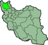 |
|
| Azerbaijan, West | Urmia Urmia - Demographics :According to official census of 2006, the population of Urmia is about 871,204.- Language :The population of Urmia is mainly Azerbaijani people, with Kurdish, Assyrian Christian, and Armenian minorities... |
37437 km² (14,454.5 sq mi) | 2,949,426 | 78.8 PD/sqkm | 14 | During the Pahlavi Dynasty Pahlavi dynasty The Pahlavi dynasty consisted of two Iranian/Persian monarchs, father and son Reza Shah Pahlavi and Mohammad Reza Shah Pahlavi The Pahlavi dynasty consisted of two Iranian/Persian monarchs, father and son Reza Shah Pahlavi (reg. 1925–1941) and Mohammad Reza Shah Pahlavi The Pahlavi dynasty ... Urmia Urmia - Demographics :According to official census of 2006, the population of Urmia is about 871,204.- Language :The population of Urmia is mainly Azerbaijani people, with Kurdish, Assyrian Christian, and Armenian minorities... was known as Rezaiyeh. |
 |
| Bushehr Bushehr Province Bushehr Province is one of the 31 provinces of Iran. It is in the south of the country, with a long coastline onto the Persian Gulf. Its center is Bandar-e-Bushehr, the provincial capital. The province has nine counties: Bushehr, Dashtestan, Dashti, Dayyer, Deylam, Jam, Kangan, Ganaveh and Tangestan... |
Bushehr Bushehr Bushehr Bushehr lies in a vast plain running along the coastal region on the Persian Gulf coast of southwestern Iran. It is the chief seaport of the country and the administrative centre of its province. Its location is about south of Tehran. The local climate is hot and humid.The city... |
22743 km² (8,781.1 sq mi) | 887,115 | 35.9 PD/sqkm | 9 | Originally part of Fars province. Until 1977, the province was known as Khalij-e Fars (Persian Gulf). | 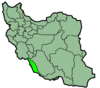 |
| Chahar Mahaal and Bakhtiari Chaharmahal and Bakhtiari Province Chaharmahal and Bakhtiari Province is one of the 31 provinces of Iran. It lies in the southwestern part of the country. Its capital is Shahrekord.It has an area of 16,332 square kilometers and a population of 842,000 .- People and culture :... |
Shahrekord Shahrekord -External links:**... |
16332 km² (6,305.8 sq mi) | 842,002 | 51.6 PD/sqkm | 6 | Until 1973 was part of Isfahan province. |  |
| Fars | Shiraz Shiraz, Iran Shiraz is the sixth most populous city in Iran and is the capital of Fars Province, the city's 2009 population was 1,455,073. Shiraz is located in the southwest of Iran on the Roodkhaneye Khoshk seasonal river... |
122608 km² (47,339.2 sq mi) | 4,385,869 | 35.8 PD/sqkm | 23 | 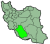 |
|
| Gilan Gilan Province Gilan Province is one of the 31 provinces of Iran. It lies along the Caspian Sea, just west of the province of Mazandaran, east of the province of Ardabil, north of the provinces of Zanjan and Qazvin.... |
Rasht Rasht Rasht is a city in and the capital of Gilan Province, Iran. At the 2006 census, its population was 551,161, in 159,983 families.Rasht is the largest city on Iran's Caspian Sea coast. It is a major trade center between Caucasia, Russia and Iran using the port of Bandar-e Anzali... |
14042 km² (5,421.6 sq mi) | 2,410,523 | 171.7 PD/sqkm | 16 | 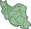 |
|
| Golestan Golestan Province Golestan Province is one of the 31 provinces of Iran, located in the north-east of the country, south of the Caspian Sea. Its capital is Gorgan.... |
Gorgan Gorgan Gorgan Some east of Gorgan is the Golestan National Park. The city has a regional airport and several universities. Gorgan Airport was opened in September 2005.-Etymology:... |
20195 km² (7,797.3 sq mi) | 1,637,063 | 81.1 PD/sqkm | 11 | On the 31 May 1997, the shahrestans of Aliabad, Gonbad-e-kavus, Gorgan, Kordkuy, Minudasht, and Torkaman were separated from Mazandaran province to form Golestan province. Gorgan Gorgan Gorgan Some east of Gorgan is the Golestan National Park. The city has a regional airport and several universities. Gorgan Airport was opened in September 2005.-Etymology:... was called Esteraba or Astarabad until 1937. |
 |
| Hamadan Hamadan Province Hamedan Province is one of the 31 provinces of Iran. Its center is Hamedan city. The province of Hamedan covers an area of 19,546 km². In the year 1996, Hamedan province had a population of approximately 1.7 million people.... |
Hamadan Hamadan -Culture:Hamadan is home to many poets and cultural celebrities. The city is also said to be among the world's oldest continuously inhabited cities.Handicrafts: Hamadan has always been well known for handicrafts like leather, ceramic, and beautiful carpets.... |
19368 km² (7,478 sq mi) | 1,790,770 | 91 PD/sqkm | 8 | Originally part of Kermanshah province. |  |
| Hormozgān Hormozgan Province Hormozgan Province is one of the 31 provinces of Iran. It is in the south of the country, facing Oman. Its area is , and its provincial capital is Bandar Abbas... |
Bandar Abbas Bandar Abbas Bandar-Abbas or Bandar-e ‘Abbās , also Romanized as Bandar ‘Abbās, Bandar ‘Abbāsī, and Bandar-e ‘Abbās; formerly known as Cambarão and Port Comorão to Portuguese traders, as Gombroon to English traders and as Gamrun or Gumrun to Dutch merchants) is a port city and capital of Hormozgān Province on... |
70669 km² (27,285.5 sq mi) | 1,410,667 | 18.6 PD/sqkm | 11 | Originally part of Kerman province. Until 1977, the province was known as Banader va Jazayer-e Bahr-e Oman (Ports and Islands of the Sea of Oman). |  |
| Ilam Ilam Province Ilam Province is one of the 31 provinces of Iran. It is in the south-west of the country, bordering Iraq. Its provincial center is the city of Ilam. Covering an area of 19,086 square kilometers, the cities of the province are Ilam, Mehran, Dehloran, Dareh Shahr, Sarable, Eyvan, Abdanan and Arkwaz... |
Ilam Ilam, Iran Ilam is a city in and the capital of Ilam Province, Iran. At the 2006 census, its population was 155,289, in 34,549 families.The Kabir Kuh mountain range lies east of the city. From the west it borders Iraq. The city is populated by Kurds and speak Kurdish.-Climate:Ilam is situated in the cold... |
20133 km² (7,773.4 sq mi) | 545,093 | 27.1 PD/sqkm | 7 | Originally part of Kermanshah province. |  |
| Isfahan | Isfahan Isfahan (city) Isfahan , historically also rendered in English as Ispahan, Sepahan or Hispahan, is the capital of Isfahan Province in Iran, located about 340 km south of Tehran. It has a population of 1,583,609, Iran's third largest city after Tehran and Mashhad... |
107029 km² (41,324.1 sq mi) | 4,590,595 | 41.6 PD/sqkm | 21 | In 1986, some parts of Markazi province were transferred to Isfahan, Semnan, and Zanjan provinces. |  |
| Kerman | Kerman Kerman - Geological characteristics :For the Iranian paleontologists, Kerman has always been considered a fossil paradise. Finding new dinosaur footprints in 2005 has now revealed new hopes for paleontologists to better understand the history of this area.- Economy :... |
180836 km² (69,821.2 sq mi) | 2,660,927 | 13.5 PD/sqkm | 14 |  |
|
| Kermanshah Kermanshah Province Kermanshah Province is one of the 31 provinces of Iran. The province was known from 1969 to 1986 as Kermanshahan and from 1986 to 1995 as Bakhtaran.-Counties:... |
Kermanshah Kermanshah Kermanshah is a city in and the capital of Kermanshah Province, Iran. At the 2006 census, its population was 784,602, in 198,117 families.The overwhelming majority of Kermanshahi people are Shi'a Muslims... |
24998 km² (9,651.8 sq mi) | 1,938,060 | 77.5 PD/sqkm | 13 | Between 1950 and 1979, both Kermanshah province and city were known as Kermanshahan and between 1979 and 1995 were known as Bakhtaran. | 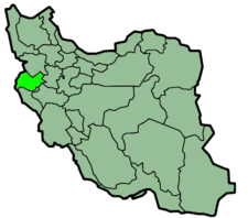 |
| Khorasan, North North Khorasan Province North Khorasan Province is a province located in northeastern Iran. Bojnord is the centre of the province.Other counties are Shirvan, Esfarayen, Maneh-o-Samalqan, Jajarm, Faroj and Germeh.... |
Bojnourd | 28434 km² (10,978.4 sq mi) | 820,918 | 27.7 PD/sqkm | 6 | On 29 September 2004, Khorasan was divided into three provinces. North Khorasan; Razavi Khorasan; South Khorasan. |  |
| Khorasan, Razavi Razavi Khorasan Province Razavi Khorasan Province is a province located in northeastern Iran. Mashhad is the centre and capital of the province.Other cities and townships are Ghouchan, Dargaz, Chenaran, Sarakhs, Fariman, Torbat-e Heydarieh, Torbat-e Jam, Taybad, Khaf, Roshtkhar, Kashmar, Bardaskan, Nishapur, Sabzevar,... |
Mashhad Mashhad Mashhad , is the second largest city in Iran and one of the holiest cities in the Shia Muslim world. It is also the only major Iranian city with an Arabic name. It is located east of Tehran, at the center of the Razavi Khorasan Province close to the borders of Afghanistan and Turkmenistan. Its... |
144681 km² (55,861.6 sq mi) | 5,620,770 | 36 PD/sqkm | 19 | On 29 September 2004, Khorasan was divided into three provinces. North Khorasan; Razavi Khorasan; South Khorasan. |  |
| Khorasan, South South Khorasan Province South Khorasan Province is a province located in eastern Iran. Birjand is the centre of the province. The other major cities are Ferdows and Qaen.... |
Birjand Birjand Birjand is the east Iranian provincial capital of South Khorasan and the centre of the county Birjand resp. Quhestan, known for its saffron, barberry, rug and handmade carpet exports.... |
69555 km² (26,855.3 sq mi) | 640,218 | 7.3 PD/sqkm | 8 | On 29 September 2004, Khorasan was divided into three provinces. North Khorasan; Razavi Khorasan; South Khorasan. |  |
| Khuzestan Khuzestan Province Khuzestan Province is one of the 31 provinces of Iran. It is in the southwest of the country, bordering Iraq's Basra Province and the Persian Gulf. Its capital is Ahwaz and covers an area of 63,238 km²... |
Ahvaz Ahvaz -History:For a more comprehensive historical treatment of the area, see the history section of Khūzestān Province.-Ancient history:Ahvaz is the anagram of "Avaz" and "Avaja" which appear in Darius's epigraph... |
64055 km² (24,731.8 sq mi) | 4,345,607 | 67.8 PD/sqkm | 18 |  |
|
| Kohgiluyeh and Boyer-Ahmad | Yasuj Yasuj Yasuj is a city in and the capital of Kohgiluyeh and Boyer-Ahmad Province, Iran. At the 2006 census, its population was 96,786, in 20,297 families.Yasuj is an industrial city in the Zagros Mountains of southwestern Iran... |
15504 km² (5,986.1 sq mi) | 695,099 | 44.8 PD/sqkm | 5 | Originally part of Khuzestan province. Until 1990, the province was known as Bovir Ahmadi and Kohkiluyeh. |  |
| Kurdistan Kurdistan Province Kurdistan Province or Kordestan Province or Kurdestan Province is one of the 31 provinces of Iran, not to be confused with the greater geographical area of Iranian Kurdistan. The province of Kurdistan is 28,817 km² in area which encompasses just one-fourth of the Kurdish inhabited areas of Iran or... |
Sanandaj Sanandaj Sanandaj , also Romanized as Senneh and Sinneh) is a city in and the capital of Kurdistan Province, Iran. At the 2006 census, its population was 311,446, in 81,380 families.... |
29137 km² (11,249.9 sq mi) | 1,574,118 | 54 PD/sqkm | 9 | Originally part of Gilan province. |  |
| Lorestan Lorestan Province Lorestan Province is a historic territory and province of western Iran, amidst the Zagros Mountains. The population of Lorestan was estimated at 1,716,527 people in 2006.Lorestan covers an area of 28,392 km²... |
Khorramabad Khorramabad Khorramabad is a city in and capital of Lorestan Province, Iran. At the 2006 census, its population was 328,544, in 75,945 families. Khorramabad is situated in the Zagros Mountains... |
28294 km² (10,924.4 sq mi) | 1,758,628 | 62.2 PD/sqkm | 9 | Originally part of Khuzestan province. |  |
| Markazi Markazi Province Markazi Province is one of the 31 provinces of Iran. The word markazi means central in Persian. Markazi lies in western Iran. Its capital is Arak. Its population is estimated at 1.35 million... |
Arak Arak, Iran -Industries:thumb|right|250px|wagon parsArak is one of the main industrial cities of Iran, possessing many plants for heavy industries especially for the metal and machinery industries, including:... |
29130 km² (11,247.2 sq mi) | 1,361,394 | 46.7 PD/sqkm | 10 | Originally part of Mazandaran province. In 1986, some parts of Markazi province were transferred to Isfahan, Semnan, and Zanjan provinces. |  |
| Mazandaran Mazandaran Province Mazandaran Province is a Caspian province in the north of Iran. Located on the southern coast of the Caspian Sea, it is bordered clockwise by the Golestan, Semnan, Tehran, Alborz, Qazvin, and Gilan provinces.... |
Sari Sari, Iran Sari is the provincial capital of Mazandaran and former capital of Iran , located in the north of Iran, between the northern slopes of the Alborz Mountains and southern coast of the Caspian Sea... |
23701 km² (9,151 sq mi) | 2,940,831 | 118.9 PD/sqkm | 15 |  |
|
| Qazvin Qazvin Province The Qazvin Province is one of the 31 provinces of Iran. It is in the north-west of the country, and its center is the city of Qazvin. The province was created in 1993 out of part of Tehran Province and includes 20 cities: Qazvin, Takestan, Abyek, Buin-Zahra, Eqhbalieh, Mohammadieh, Alvand,... |
Qazvin Qazvin Qazvin is the largest city and capital of the Province of Qazvin in Iran. At the 2006 census, its population was 349,821, in 96,420 families.... |
15549 km² (6,003.5 sq mi) | 1,166,861 | 75 PD/sqkm | 5 | On 31 December 1996, the shahrestans of Qazvin and Takestan were separated from Zanjan province to form the province of Qazvin. |  |
| Qom Qom Province Qombol Province is one of the 31 provinces of Iran with 11,237 km², covering 0.89% of the total area in Iran. It is in the north of the country, and its provincial capital is the city of Qom. It was formed from part of Tehran Province in 1995. In 2005, this province had a population of... |
Qom Qom Qom is a city in Iran. It lies by road southwest of Tehran and is the capital of Qom Province. At the 2006 census, its population was 957,496, in 241,827 families. It is situated on the banks of the Qom River.... |
11526 km² (4,450.2 sq mi) | 1,064,456 | 92.4 PD/sqkm | 1 | Until 1995, Qom was a shahrestan of Tehran province. | 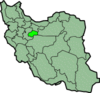 |
| Semnan Semnan Province Semnan Province is one of the 31 provinces of Iran. It is in the north of the country, and its center is Semnan. The province of Semnan covers an area of 96,816 square kilometers and stretches along the Alborz mountain range and borders to Dasht-e Kavir desert in its southern parts.Counties of... |
Semnan | 97491 km² (37,641.5 sq mi) | 590,512 | 6 PD/sqkm | 4 | Originally part of Mazandaran province. In 1986, some parts of Markazi province were transferred to Isfahan, Semnan, and Zanjan provinces. |  |
| Sistan and Baluchistan |
Zahedan Zahedan Zahedan is a city in and the capital of Sistan and Baluchestan Province, Iran. At the 2006 census, its population was 552,706, in 109,488 families.-Geography:... |
181785 km² (70,187.6 sq mi) | 2,410,076 | 12.6 PD/sqkm | 8 | Until 1986, the province was known as Baluchestan and Sistan. |  |
| Tehran Tehran Province Tehran Province is one of the 31 provinces of Iran. It covers on area of 18,909 square kilometers and is located to the north of the central plateau of Iran.... |
Tehran Tehran Tehran , sometimes spelled Teheran, is the capital of Iran and Tehran Province. With an estimated population of 8,429,807; it is also Iran's largest urban area and city, one of the largest cities in Western Asia, and is the world's 19th largest city.In the 20th century, Tehran was subject to... |
18814 km² (7,264.1 sq mi) | 13,530,742 | 645.8 PD/sqkm | 13 | Until 1986, Tehran was part of Markazi province. | 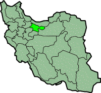 |
| Yazd Yazd Province Yazd Province is one of the 31 provinces of Iran. It is in the centre of the country, and its administrative center is the city of Yazd.The province has an area of 131,575 km², and according to the most recent divisions of the country, is divided into eleven counties: Maybod, Mehreez, Taft,... |
Yazd Yazd Yazd is the capital of Yazd Province in Iran, and a centre of Zoroastrian culture. The city is located some 175 miles southeast of Isfahan. At the 2006 census, the population was 423,006, in 114,716 families.... |
129285 km² (49,917.2 sq mi) | 992,318 | 7.4 PD/sqkm | 10 | Originally part of Isfahan province. In 1986, part of Kerman province was transferred to Yazd province. In 2002, Tabas shahrestan (area: 55,344 km²) was transferred from Khorasan province to Yazd. |  |
| Zanjan Zanjan Province Zanjan Province is one of the 31 provinces of Iran. Located in the North West of Iran, its capital is Zanjan city. Zanjan province with an area of 36,400 km² has a mostly rural, population of 964,601 . The province lies 330 km northwest of Tehran, connected to it via a freeway.Zanjan... |
Zanjan Zanjan (city) Zanjan is the capital of Zanjan Province in northwestern Iran. It is an Azeri inhabited city. It lies 298 km north-west of Tehran on the main highway to Tabriz and Turkey and approximately 125 km from the Caspian Sea... |
21773 km² (8,406.6 sq mi) | 970,946 | 44.6 PD/sqkm | 7 | Originally part of Gilan province. In 1986, some parts of Markazi province were transferred to Isfahan, Semnan, and Zanjan provinces. | 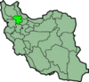 |
| Iran Iran Iran , officially the Islamic Republic of Iran , is a country in Southern and Western Asia. The name "Iran" has been in use natively since the Sassanian era and came into use internationally in 1935, before which the country was known to the Western world as Persia... (Total) |
Tehran Tehran Tehran , sometimes spelled Teheran, is the capital of Iran and Tehran Province. With an estimated population of 8,429,807; it is also Iran's largest urban area and city, one of the largest cities in Western Asia, and is the world's 19th largest city.In the 20th century, Tehran was subject to... |
1628554 km² (628,788.2 sq mi) | 71,767,413 | 44 PD/sqkm | 324 |
See also
- List of current Iranian provincial governors-general
- Counties of IranCounties of IranThe provinces of Iran further subdivided into counties called shahrestan , an area inside an ostan, and consists of a city centre, few bakhsh and many villages around them. There are usually a few cities and rural agglomerations in each county. Rural agglomerations are a collection of a number...
- Geography of IranGeography of IranIran is located in southwest Asia and borders the Gulf of Oman, Persian Gulf, and Caspian Sea.Its mountains have helped to shape both the political and the economic history of the country for several centuries. The mountains enclose several broad basins, or plateaus, on which major agricultural and...
- ISO 3166-2:IRISO 3166-2:IRISO 3166-2:IR is the entry for Iran in ISO 3166-2, part of the ISO 3166 standard published by the International Organization for Standardization , which defines codes for the names of the principal subdivisions of all countries coded in ISO 3166-1.Currently for Iran, ISO 3166-2 codes are defined...
External links
- Statistical Centre, Government of Iran
- Iranian Provinces Investment - Trade Promotion Organization of Iran, affiliated to the Ministry of Commerce (Iran)Ministry of Commerce (Iran)The Ministry of Commerce of Iran was the main organ of the Government in charge of the regulation and implementation of policies applicable to domestic and foreign trade...
- Ministry of Interior
- Official website of Ardabil Governorship
- Official website of East Azarbaijan Governor’s Office
- Official website of West Azarbaijan Governor’s Office
- Official website of Bushehr Governorship
- Official website of Chahar Mahaal and Bakhtiari Governorship
- Official website of Fars Governorship
- Official website of Gilan Governorship
- Official website of Golestan Governorship
- Official website of Hamedan Governorship
- Official website of Hormozgan Governorship
- Official website of Ilam Governorship
- Official website of Isfahan Governorship
- Official website of Kerman Governorship
- Official website of Kermanshah Governorship
- Official website of North Khorasan Governorship
- Official website of Razavi Khorasan Governorship
- Official website of South Khorasan Governorship
- Official website of Khuzestan Governorship
- Official website of Kohgiluyeh and Buyer Ahmad Governorship
- Official website of Kurdistan Governorship
- Lorestān Governor's Office
- Official website of Markazi Governorship
- Official website of Mazandaran Governorship
- Official website of Qazvin Governorship
- Qom province portal
- Official website of Semnan Governorship
- Official website of Sistan and Baluchestan Governorship
- Official website of Tehran Governorship
- Official website of Yazd Governorship
- Official website of Zanjan Governorship