
Prince of Wales Island, Torres Strait
Encyclopedia
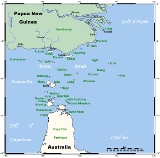
Prince of Wales Island (Muralug Island) is an island
20 km (12.4 mi) north of Muttee Heads
which is adjacent to Bamaga
at the tip of Cape York Peninsula
within the Endeavour Strait
Queensland
, Australia
in the Torres Strait
and south of Thursday Island.
With an area of 204.6 km² (79 sq mi), Prince of Wales Island is the largest of the Torres Strait Islands
. Being inhabited only by a few Kaurareg families (population 20 in 2001), it is very sparsely populated. The village in the north is called Muralug, after the native name of the island. The northeastern corner of the island, Kiwain Point, is only 830 m (908 yd) away from Vivien Point of Thursday Island, the main and most populous of the Torres Strait Islands, separated by Normanby Sound.
Muralag or Muralug Island, also known as Prince of Wales, comes under the jurisdiction of Torres Shire Council. However most of the land has been returned to the Kaurareg People, who are the traditional owners of the island.
Island
An island or isle is any piece of sub-continental land that is surrounded by water. Very small islands such as emergent land features on atolls can be called islets, cays or keys. An island in a river or lake may be called an eyot , or holm...
20 km (12.4 mi) north of Muttee Heads
Muttee Heads
Muttee Heads is about 20 km West of Bamaga at the tip of Cape York Peninsula.During World War II the No 52 Radar Station moved from Mascot in New South Wales to Townsville in north Queensland and finally to Muttee Head on Cape York in far north Queensland.No...
which is adjacent to Bamaga
Bamaga, Queensland
-Language:The community languages of Bamaga are Kalaw Kawaw Ya, Brokan , and English, particularly for education and government business.-Industry:...
at the tip of Cape York Peninsula
Cape York Peninsula
Cape York Peninsula is a large remote peninsula located in Far North Queensland at the tip of the state of Queensland, Australia, the largest unspoilt wilderness in northern Australia and one of the last remaining wilderness areas on Earth...
within the Endeavour Strait
Endeavour Strait
The Endeavour Strait is a strait running between the Australian mainland and Prince of Wales Island, in the extreme south of the Torres Strait...
Queensland
Queensland
Queensland is a state of Australia, occupying the north-eastern section of the mainland continent. It is bordered by the Northern Territory, South Australia and New South Wales to the west, south-west and south respectively. To the east, Queensland is bordered by the Coral Sea and Pacific Ocean...
, Australia
Australia
Australia , officially the Commonwealth of Australia, is a country in the Southern Hemisphere comprising the mainland of the Australian continent, the island of Tasmania, and numerous smaller islands in the Indian and Pacific Oceans. It is the world's sixth-largest country by total area...
in the Torres Strait
Torres Strait
The Torres Strait is a body of water which lies between Australia and the Melanesian island of New Guinea. It is approximately wide at its narrowest extent. To the south is Cape York Peninsula, the northernmost continental extremity of the Australian state of Queensland...
and south of Thursday Island.
With an area of 204.6 km² (79 sq mi), Prince of Wales Island is the largest of the Torres Strait Islands
Torres Strait Islands
The Torres Strait Islands are a group of at least 274 small islands which lie in Torres Strait, the waterway separating far northern continental Australia's Cape York Peninsula and the island of New Guinea but Torres Strait Island known and Recognize as Nyumaria.The islands are mostly part of...
. Being inhabited only by a few Kaurareg families (population 20 in 2001), it is very sparsely populated. The village in the north is called Muralug, after the native name of the island. The northeastern corner of the island, Kiwain Point, is only 830 m (908 yd) away from Vivien Point of Thursday Island, the main and most populous of the Torres Strait Islands, separated by Normanby Sound.
Muralag or Muralug Island, also known as Prince of Wales, comes under the jurisdiction of Torres Shire Council. However most of the land has been returned to the Kaurareg People, who are the traditional owners of the island.