

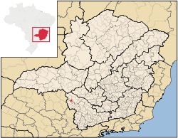
Pratápolis
Encyclopedia
Minas Gerais
Minas Gerais is one of the 26 states of Brazil, of which it is the second most populous, the third richest, and the fourth largest in area. Minas Gerais is the Brazilian state with the largest number of Presidents of Brazil, the current one, Dilma Rousseff, being one of them. The capital is the...
. Its population as of 2007 was 8,653 people living in a total area of 214 km². The city belongs to the meso-region of Sul e Sudoeste de Minas and to the micro-region of Passos
Passos, Minas Gerais
Passos is a Brazilian municipality located in the southwest of the state of Minas Gerais. Its population as of 2007 was 122,765 people living in a total area of 1,339 km². The city belongs to the meso-region of Sul e Sudoeste de Minas and to the micro-region of Passos...
. It became a municipality in 1943.
Location
The city center of Pratápolis is located at an elevation of 735 meters in the southwest of the state, a short distance west of regional center, PassosPassos
-People:* Cristiano Ávalos dos Passos* John Dos Passos* Márcio Emerson Passos de Albuquerque, a Brazilian footballer* Rosa Passos* Vítor Hugo Gomes Passos, a Portuguese footballer-Brazil:* Passos, Minas Gerais, a municipality in the State of Minas Gerais...
. For the most part the terrain is hilly with the maximum elevation reaching 1,012 meters. Neighboring municipalities are: Cássia
Cássia
Cássia is a Brazilian municipality located in the center of the state of Minas Gerais. Its population as of 2000 was 17,027 people living in a total area of 643 km². The city belongs to the meso-region of Sul e Sudoeste de Minas and to the micro-region of Passos...
(N, Itaú de Minas
Itaú de Minas
Itaú de Minas is a Brazilian municipality located in the center of the state of Minas Gerais. Its population as of 2007 was 14,551 people living in a total area of 154 km². The city belongs to the meso-region of Sul e Sudoeste de Minas and to the micro-region of Passos...
and Fortaleza de Minas
Fortaleza de Minas
Fortaleza de Minas is a Brazilian municipality located in the southwest of the state of Minas Gerais. Its population as of 2007 was 3,837 people living in a total area of 218 km². The city belongs to the meso-region of Sul e Sudoeste de Minas and to the micro-region of Passos...
(E), São Sebastião do Paraíso
São Sebastião do Paraíso
São Sebastião do Paraíso is a Brazilian municipality located in the southwest of the state of Minas Gerais. Its population as of 2007 was 61,838 people living in a total area of 822 km². The city belongs to the meso-region of Sul e Sudoeste de Minas and to the micro-region of São Sebastião do...
(S and SW), and Capetinga
Capetinga
Capetinga is a Brazilian municipality located in the southwest of the state of Minas Gerais. Its population as of 2007 was 7,154 people living in a total area of 296 km². The city belongs to the meso-region of Sul e Sudoeste de Minas and to the micro-region of Passos. It became a municipality...
(W).
Temperatures
- Average annual: 21.3°C
- Average annual maximum: 26°C
- Average annual minimum: 15°C
Distances
- Belo HorizonteBelo HorizonteBelo Horizonte is the capital of and largest city in the state of Minas Gerais, located in the southeastern region of Brazil. It is the third largest metropolitan area in the country...
: 358 km - MG-050: 9 km
- CássiaCássiaCássia is a Brazilian municipality located in the center of the state of Minas Gerais. Its population as of 2000 was 17,027 people living in a total area of 643 km². The city belongs to the meso-region of Sul e Sudoeste de Minas and to the micro-region of Passos...
: 33 km - Itaú de MinasItaú de MinasItaú de Minas is a Brazilian municipality located in the center of the state of Minas Gerais. Its population as of 2007 was 14,551 people living in a total area of 154 km². The city belongs to the meso-region of Sul e Sudoeste de Minas and to the micro-region of Passos...
: 12 km - PassosPassos-People:* Cristiano Ávalos dos Passos* John Dos Passos* Márcio Emerson Passos de Albuquerque, a Brazilian footballer* Rosa Passos* Vítor Hugo Gomes Passos, a Portuguese footballer-Brazil:* Passos, Minas Gerais, a municipality in the State of Minas Gerais...
: 33 km - FrancaFranca-Demography:*Total: 328.473 inhabitants on July 1, 2006.** Urban: 324.138** Rural: 6.999*Demographic density : 473,80*Child mortality until 1 year : 12,66 = 1,26%*Life expectancy : 73,03*Fertility : 2,26...
: 80 km - Ribeirão PretoRibeirão PretoRibeirão Preto is a municipality and city in the Northeastern region of the state of São Paulo in Brazil. It is nicknamed Brazilian California, because of a combination of an economy based on agrobusiness plus high technology, wealth and sunny weather all year long. With 605,114 inhabitants,...
: 133 km - São Sebastião do ParaísoSão Sebastião do ParaísoSão Sebastião do Paraíso is a Brazilian municipality located in the southwest of the state of Minas Gerais. Its population as of 2007 was 61,838 people living in a total area of 822 km². The city belongs to the meso-region of Sul e Sudoeste de Minas and to the micro-region of São Sebastião do...
: 28 km - São PauloSão PauloSão Paulo is the largest city in Brazil, the largest city in the southern hemisphere and South America, and the world's seventh largest city by population. The metropolis is anchor to the São Paulo metropolitan area, ranked as the second-most populous metropolitan area in the Americas and among...
: 420 km
Economic activities
Services, small industrris, and agriculture are the main economic activities. The city has a cement factory: CCPI - Companhia de Cimento Portland Itaú. The GDP in 2005 was approximately R$54 million, with 3 million reais from taxes, 32 million reais from services, 5 million reais from industry, and 14 million reais from agriculture. In the industrial sector there were 74 small industries employing 148 workers (2005). There were 400 rural producers on 2,000 hectares of land. There was also modest poulty production. Approximately 1,000 persons were occupied in agriculture. The main crops are coffee, beans, and corn. There were 17,000 head of cattle, of which 2,000 were milk cows (2006).There are 2 banks (2007). In the vehicle fleet there were 1,751 automobiles, 146 trucks, 124 pickup trucks, 10 buses, and 444 motorcycles (2007).
Health and education
In the health sector there were 2 health clinics and 1 hospital with 5 beds (2005). Educational needs of 1,900 students were attended to by 4 primary schools, 1 middle school, and 1 pre-primary school.- Municipal Human Development IndexHuman Development IndexThe Human Development Index is a composite statistic used to rank countries by level of "human development" and separate "very high human development", "high human development", "medium human development", and "low human development" countries...
: 0.772 (2000) - State ranking: 156 out of 853 municipalities as of 2000
- National ranking: 1261 out of 5,138 municipalities as of 2000
- Literacy rate: 89%
- Life expectancy: 72 (average of males and females)
In 2000 the per capita monthly income of R$230.00 was below the state average of R$276.00 and below the national average of R$297.00. Poços de Caldas
Poços de Caldas
Poços de Caldas is a city and municipality in south-western Minas Gerais state, Brazil, in the microregion of the same name. Its estimated population in 2009 was 151,449 inhabitants...
had the highest per capita monthly income in 2000 with R$435.00. The lowest was Setubinha
Setubinha
Setubinha is a municipality in the northeast of the Brazilian state of Minas Gerais. As of 2007 the population was 10,834 in a total area of 536 km². The elevation is 729 metres. It is part of the IBGE statistical microregion of Teófilo Otoni...
with R$73.00.
The highest ranking municipality in Minas Gerais in 2000 was Poços de Caldas
Poços de Caldas
Poços de Caldas is a city and municipality in south-western Minas Gerais state, Brazil, in the microregion of the same name. Its estimated population in 2009 was 151,449 inhabitants...
with 0.841, while the lowest was Setubinha
Setubinha
Setubinha is a municipality in the northeast of the Brazilian state of Minas Gerais. As of 2007 the population was 10,834 in a total area of 536 km². The elevation is 729 metres. It is part of the IBGE statistical microregion of Teófilo Otoni...
with 0.568. Nationally the highest was São Caetano do Sul
São Caetano do Sul
São Caetano do Sul is a city in São Paulo state in Brazil, located in the Greater São Paulo Metropolitan Area. It is the city with the highest per capita income in Brazil and it also has the highest Human Development Index .-Geography:São Caetano do Sul is located on a plateau that is part of the...
in São Paulo with 0.919, while the lowest was Setubinha. In more recent statistics (considering 5,507 municipalities) Manari in the state of Pernambuco
Pernambuco
Pernambuco is a state of Brazil, located in the Northeast region of the country. To the north are the states of Paraíba and Ceará, to the west is Piauí, to the south are Alagoas and Bahia, and to the east is the Atlantic Ocean. There are about of beaches, some of the most beautiful in the...
has the lowest rating in the country—0,467—putting it in last place.