

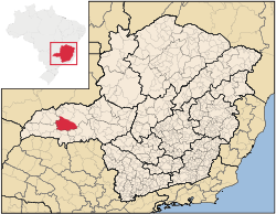
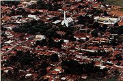
Prata (Minas Gerais)
Encyclopedia

Brazil
Brazil , officially the Federative Republic of Brazil , is the largest country in South America. It is the world's fifth largest country, both by geographical area and by population with over 192 million people...
ian municipality located in the west of the state of Minas Gerais
Minas Gerais
Minas Gerais is one of the 26 states of Brazil, of which it is the second most populous, the third richest, and the fourth largest in area. Minas Gerais is the Brazilian state with the largest number of Presidents of Brazil, the current one, Dilma Rousseff, being one of them. The capital is the...
. Its population as of 2008 was 26,573 living in a total area of 4,856 km². The city belongs to the statistical mesoregion
Mesoregion (Brazil)
Mesoregions are subdivisions of Brazilian states, grouping together various municipalities in proximity and with common characteristics. They were created by the Brazilian Institute of Geography and Statistics for statistical purposes and do not, therefore, constitute an administrative area....
of Triângulo Mineiro
Triângulo Mineiro
The Triangle Mineiro Portuguese pronunciation: [tɾiɐɡulu minejru] is an officer in the region west of the state of Minas Gerais, Brazil. The area is 93.500 km ² and is limited by the Serra da Canastra and Marcela, east, south of Sao Paulo, Goias in the north and west of the junction of the rivers...
and Alto Paranaíba and to the statistical microregion
Microregion (Brazil)
Microregions are legally defined administrative areas in Brazil consisting of groups of municipalities bordering urban areas. Microregions are grouped together into mesoregions....
of Uberlândia
Uberlândia
Uberlândia is the main town in the Triangle region, west of the state of Minas Gerais, Brazil. With a population of 604,013 inhabitants, according to 2010 estimates, the city is the second largest in the state second only to Belo Horizonte...
. It became a municipality in 1873.
Location
Prata is located at an elevation of 631 meters in the rich region known as the Triângulo MineiroTriângulo Mineiro
The Triangle Mineiro Portuguese pronunciation: [tɾiɐɡulu minejru] is an officer in the region west of the state of Minas Gerais, Brazil. The area is 93.500 km ² and is limited by the Serra da Canastra and Marcela, east, south of Sao Paulo, Goias in the north and west of the junction of the rivers...
. It is southwest of Uberlândia
Uberlândia
Uberlândia is the main town in the Triangle region, west of the state of Minas Gerais, Brazil. With a population of 604,013 inhabitants, according to 2010 estimates, the city is the second largest in the state second only to Belo Horizonte...
and northwest of Uberaba
Uberaba
Uberaba is a city and municipality in the west of the state of Minas Gerais in Brazil. Its population is 296.000 with an area of 4529.7 km², giving a density of 60.71 people per km². It is located on a plateau at an elevation of 785 meters and is in the Uberaba River floodplain...
and is connected to Uberlândia by federal highway BR-497.
The distance to Uberlândia
Uberlândia
Uberlândia is the main town in the Triangle region, west of the state of Minas Gerais, Brazil. With a population of 604,013 inhabitants, according to 2010 estimates, the city is the second largest in the state second only to Belo Horizonte...
is 74 km; and the distance to Belo Horizonte
Belo Horizonte
Belo Horizonte is the capital of and largest city in the state of Minas Gerais, located in the southeastern region of Brazil. It is the third largest metropolitan area in the country...
is 640 km. Neighboring municipalities are: Monte Alegre de Minas
Monte Alegre de Minas
Monte Alegre de Minas is a Brazilian municipality located in the west of the state of Minas Gerais. Its population as of 2007 was 18,348 living in a total area of 2,593 km². The city belongs to the statistical mesoregion of Triângulo Mineiro and Alto Paranaíba and to the statistical microregion of...
(N); Ituiutaba
Ituiutaba
Ituiutaba is a city and municipality in the western part of Minas Gerais state, Brazil. Elevated to city status in 1901, it had a population in 2007 of 100,316 and a total area in the municipality of 2,694 km²...
, Campina Verde
Campina Verde
Campina Verde is a municipality in the north of the Brazilian state of Minas Gerais. As of 2007 the population was 18,680 in a total area of 3,663 km². It became a municipality in 1938.-Location:...
(W) ; Comendador Gomes
Comendador Gomes
Comendador Gomes is a municipality in the west of the Brazilian state of Minas Gerais. As of 2007 the population was 3,087 in a total area of 1,043 km². It became a municipality in 1948.-Location:...
, Campo Florido
Campo Florido
Campo Florido is a Brazilian municipality located in the west of the state of Minas Gerais. Its population as of 2007 was estimated to be 6,570 people living in a total area of 1,261 km². The city belongs to the mesoregion of Triângulo Mineiro and Alto Paranaíba and to the micro-region of Uberaba. ...
(S); Uberlândia
Uberlândia
Uberlândia is the main town in the Triangle region, west of the state of Minas Gerais, Brazil. With a population of 604,013 inhabitants, according to 2010 estimates, the city is the second largest in the state second only to Belo Horizonte...
and Veríssimo
Veríssimo
Veríssimo is a Brazilian municipality located in the west of the state of Minas Gerais. Its population as of 2007 was estimated to be 3,667 people living in a total area of 1,028 km². The city belongs to the mesoregion of Triângulo Mineiro and Alto Paranaíba and to the micro-region of Uberaba....
(E).
Economy
The main economic activities are services, agriculture, and small industries. The GDP in 2005 was R$261 million, with 112 million from services, 29 million from industry, and 102 million from agriculture. There were 1,487 rural producers on 327,000 hectares of land. 607 farms had tractors. The main crops were peanuts, rice, sugarcane, beans, corn, and soybeans (15,000 hectares). There were 344,000 head of cattle (2006).Health and education
The social indicators rank it in the top tier of municipalities in the state.- Municipal Human Development IndexHuman Development IndexThe Human Development Index is a composite statistic used to rank countries by level of "human development" and separate "very high human development", "high human development", "medium human development", and "low human development" countries...
: 0.769 (2000) - State ranking: 177 out of 853 municipalities as of 2000
- National ranking: 1368 out of 5,138 municipalities as of 2000
- Literacy rate: 87%
- Life expectancy: 70 (average of males and females)
The highest ranking municipality in Minas Gerais in 2000 was Poços de Caldas
Poços de Caldas
Poços de Caldas is a city and municipality in south-western Minas Gerais state, Brazil, in the microregion of the same name. Its estimated population in 2009 was 151,449 inhabitants...
with 0.841, while the lowest was Setubinha
Setubinha
Setubinha is a municipality in the northeast of the Brazilian state of Minas Gerais. As of 2007 the population was 10,834 in a total area of 536 km². The elevation is 729 metres. It is part of the IBGE statistical microregion of Teófilo Otoni...
with 0.568. Nationally the highest was São Caetano do Sul
São Caetano do Sul
São Caetano do Sul is a city in São Paulo state in Brazil, located in the Greater São Paulo Metropolitan Area. It is the city with the highest per capita income in Brazil and it also has the highest Human Development Index .-Geography:São Caetano do Sul is located on a plateau that is part of the...
in São Paulo with 0.919, while the lowest was Setubinha. In more recent statistics (considering 5,507 municipalities) Manari in the state of Pernambuco
Pernambuco
Pernambuco is a state of Brazil, located in the Northeast region of the country. To the north are the states of Paraíba and Ceará, to the west is Piauí, to the south are Alagoas and Bahia, and to the east is the Atlantic Ocean. There are about of beaches, some of the most beautiful in the...
has the lowest rating in the country--0,467--putting it in last place.
There was one hospital with 41 beds in 2005. Patients with more serious health conditions are taken care of in Uberlândia
Uberlândia
Uberlândia is the main town in the Triangle region, west of the state of Minas Gerais, Brazil. With a population of 604,013 inhabitants, according to 2010 estimates, the city is the second largest in the state second only to Belo Horizonte...
or Uberaba
Uberaba
Uberaba is a city and municipality in the west of the state of Minas Gerais in Brazil. Its population is 296.000 with an area of 4529.7 km², giving a density of 60.71 people per km². It is located on a plateau at an elevation of 785 meters and is in the Uberaba River floodplain...
.
Paleontology
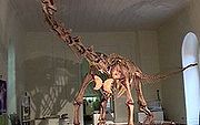
The dinosaur was called Maxakalisaurus topai and, after popular vote, it is now known as DINOPRATA.
The model of the 13 meter long titanossauro (made in resin) has been on display in the Museu Nacional do Rio de Janeiro since August, 2006.