

Portolan chart
Encyclopedia
Italy
Italy , officially the Italian Republic languages]] under the European Charter for Regional or Minority Languages. In each of these, Italy's official name is as follows:;;;;;;;;), is a unitary parliamentary republic in South-Central Europe. To the north it borders France, Switzerland, Austria and...
, Portugal
Portugal
Portugal , officially the Portuguese Republic is a country situated in southwestern Europe on the Iberian Peninsula. Portugal is the westernmost country of Europe, and is bordered by the Atlantic Ocean to the West and South and by Spain to the North and East. The Atlantic archipelagos of the...
and Spain
Spain
Spain , officially the Kingdom of Spain languages]] under the European Charter for Regional or Minority Languages. In each of these, Spain's official name is as follows:;;;;;;), is a country and member state of the European Union located in southwestern Europe on the Iberian Peninsula...
. With the advent of the Age of Discovery
Age of Discovery
The Age of Discovery, also known as the Age of Exploration and the Great Navigations , was a period in history starting in the early 15th century and continuing into the early 17th century during which Europeans engaged in intensive exploration of the world, establishing direct contacts with...
, they were considered State secrets in Portugal and Spain, very valuable in the description of Atlantic
Atlantic Ocean
The Atlantic Ocean is the second-largest of the world's oceanic divisions. With a total area of about , it covers approximately 20% of the Earth's surface and about 26% of its water surface area...
and Indian
Indian Ocean
The Indian Ocean is the third largest of the world's oceanic divisions, covering approximately 20% of the water on the Earth's surface. It is bounded on the north by the Indian Subcontinent and Arabian Peninsula ; on the west by eastern Africa; on the east by Indochina, the Sunda Islands, and...
coastlines for newcomer English
England
England is a country that is part of the United Kingdom. It shares land borders with Scotland to the north and Wales to the west; the Irish Sea is to the north west, the Celtic Sea to the south west, with the North Sea to the east and the English Channel to the south separating it from continental...
and Dutch
Netherlands
The Netherlands is a constituent country of the Kingdom of the Netherlands, located mainly in North-West Europe and with several islands in the Caribbean. Mainland Netherlands borders the North Sea to the north and west, Belgium to the south, and Germany to the east, and shares maritime borders...
raiding, and later trading, ships. The word portolan comes from the Italian
Italian language
Italian is a Romance language spoken mainly in Europe: Italy, Switzerland, San Marino, Vatican City, by minorities in Malta, Monaco, Croatia, Slovenia, France, Libya, Eritrea, and Somalia, and by immigrant communities in the Americas and Australia...
adjective portolano, meaning "related to ports or harbours."
Contents and themes
These charts, actually rough maps, were based on accounts of medieval Europeans who sailed the MediterraneanMediterranean Sea
The Mediterranean Sea is a sea connected to the Atlantic Ocean surrounded by the Mediterranean region and almost completely enclosed by land: on the north by Anatolia and Europe, on the south by North Africa, and on the east by the Levant...
and Black Sea
Black Sea
The Black Sea is bounded by Europe, Anatolia and the Caucasus and is ultimately connected to the Atlantic Ocean via the Mediterranean and the Aegean seas and various straits. The Bosphorus strait connects it to the Sea of Marmara, and the strait of the Dardanelles connects that sea to the Aegean...
coasts, and later were used to map coastal resources in the Atlantic
Atlantic Ocean
The Atlantic Ocean is the second-largest of the world's oceanic divisions. With a total area of about , it covers approximately 20% of the Earth's surface and about 26% of its water surface area...
and Indian
Indian Ocean
The Indian Ocean is the third largest of the world's oceanic divisions, covering approximately 20% of the water on the Earth's surface. It is bounded on the north by the Indian Subcontinent and Arabian Peninsula ; on the west by eastern Africa; on the east by Indochina, the Sunda Islands, and...
oceans. At the beginning of the Age of Discovery
Age of Discovery
The Age of Discovery, also known as the Age of Exploration and the Great Navigations , was a period in history starting in the early 15th century and continuing into the early 17th century during which Europeans engaged in intensive exploration of the world, establishing direct contacts with...
they would describe the coast of Africa
Africa
Africa is the world's second largest and second most populous continent, after Asia. At about 30.2 million km² including adjacent islands, it covers 6% of the Earth's total surface area and 20.4% of the total land area...
, Brazil
Brazil
Brazil , officially the Federative Republic of Brazil , is the largest country in South America. It is the world's fifth largest country, both by geographical area and by population with over 192 million people...
, India
India
India , officially the Republic of India , is a country in South Asia. It is the seventh-largest country by geographical area, the second-most populous country with over 1.2 billion people, and the most populous democracy in the world...
and even past the Strait of Malacca
Strait of Malacca
The Strait of Malacca is a narrow, stretch of water between the Malay Peninsula and the Indonesian island of Sumatra. It is named after the Malacca Sultanate that ruled over the archipelago between 1414 to 1511.-Extent:...
into Japan
Japan
Japan is an island nation in East Asia. Located in the Pacific Ocean, it lies to the east of the Sea of Japan, China, North Korea, South Korea and Russia, stretching from the Sea of Okhotsk in the north to the East China Sea and Taiwan in the south...
, knowledge vital for the slow rise to prominence of the English Armada and of Dutch merchants, following in the Iberian Powers
Iberian Peninsula
The Iberian Peninsula , sometimes called Iberia, is located in the extreme southwest of Europe and includes the modern-day sovereign states of Spain, Portugal and Andorra, as well as the British Overseas Territory of Gibraltar...
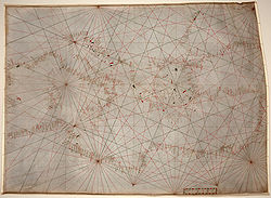
wake. Frequently drawn on sheepskin, portolan charts show coastal features and ports. In earlier days, what could be used as a harbour encompassed more of the coastline than now, as ships were smaller, they might need to seek refuge in a harbour more often, and some ships were intentionally beached for maintenance and repairs. Thus, nearly any protected bay or flat beach might be of interest to mariners, not only for safe harbour but also as previous coastal reconnaissance
Reconnaissance
Reconnaissance is the military term for exploring beyond the area occupied by friendly forces to gain information about enemy forces or features of the environment....
.
The straight lines criss-crossing many portolan charts represent the thirty-two directions (or headings) of the mariner's compass from a given point. This is similar to the compass rose
Compass rose
A compass rose, sometimes called a windrose, is a figure on a compass, map, nautical chart or monument used to display the orientation of the cardinal directions — North, East, South and West - and their intermediate points. It is also the term for the graduated markings found on the traditional...
displayed on later maps and charts. Naming or demonstrating all thirty-two points is called boxing the compass
Boxing the compass
Boxing the compass is the action of naming all thirty-two points of the compass in clockwise order. Such names are formed by the initials of the cardinal directions and their intermediate ordinal directions, and are very handy to refer to a heading in a general or colloquial fashion, without...
.
The portolan combined the exact notations of the text of the periplus
Periplus
Periplus is the Latinization of an ancient Greek word, περίπλους , literally "a sailing-around." Both segments, peri- and -plous, were independently productive: the ancient Greek speaker understood the word in its literal sense; however, it developed a few specialized meanings, one of which became...
or pilot book with the decorative illustrations of the conceptual T and O map
T and O map
A T and O map or O-T or T-O map , is a type of medieval world map, sometimes also called a Beatine map or a Beatus map because one of the earliest known representations of this sort is attributed to Beatus of Liébana, an 8th-century Spanish monk...
. In addition, the charts offered a realistic depiction of the shore, and they were meant for practical use by a mariner of the period.
Portolans failed to take into account the curvature of the earth; as a result, they were unhelpful in crossing the open ocean, as navigational tools. Instead they derived their use in close quarters identification of landmarks. Portolani were useful for navigation in smaller bodies of water, such as the Mediterranean
Mediterranean Sea
The Mediterranean Sea is a sea connected to the Atlantic Ocean surrounded by the Mediterranean region and almost completely enclosed by land: on the north by Anatolia and Europe, on the south by North Africa, and on the east by the Levant...
, Black
Black Sea
The Black Sea is bounded by Europe, Anatolia and the Caucasus and is ultimately connected to the Atlantic Ocean via the Mediterranean and the Aegean seas and various straits. The Bosphorus strait connects it to the Sea of Marmara, and the strait of the Dardanelles connects that sea to the Aegean...
, or Red Sea
Red Sea
The Red Sea is a seawater inlet of the Indian Ocean, lying between Africa and Asia. The connection to the ocean is in the south through the Bab el Mandeb strait and the Gulf of Aden. In the north, there is the Sinai Peninsula, the Gulf of Aqaba, and the Gulf of Suez...
s.
History
The oldest extant portolan is the Carta PisanaCarta Pisana
The Carta Pisana is a map made at the end of the 13th century, about 1275-1300. It was found in Pisa, hence its name. It shows the whole Mediterranean, the Black Sea and a part of the atlantic coast, from the north of present-day Morocco to present-day Holland, but the accuracy of the map is...
, dating from approximately 1296. The cartographer Angelino Dulcert
Angelino Dulcert
Angelino Dulcert , probably also the same person known as Angelino de Dalorto , and who's real name was probably Angelino de Dulceto or Dulceti or possibly Angelí Dolcet, was an Italian-Majorcan cartographer....
produced a portolan in 1339.
See also
- Catalan AtlasCatalan AtlasThe Catalan Atlas is the most important Catalan map of the medieval period. It was produced by the Majorcan cartographic school and is attributed to Cresques Abraham , a Jewish book illuminator who was self-described as being a master of the maps of the world as well as compasses...
, 1375 - Catalan chartCatalan chartCatalan charts are a subtype of the medieval period portolan chart. Portolan charts are a type of map generated by using a mariner's compass and direct observation to determine the shape and location of coastlines and ports. The term "portolan" means "pertaining to ports and harbors" and should...
- Nautical chartNautical chartA nautical chart is a graphic representation of a maritime area and adjacent coastal regions. Depending on the scale of the chart, it may show depths of water and heights of land , natural features of the seabed, details of the coastline, navigational hazards, locations of natural and man-made aids...
- Pietro VescontePietro VescontePietro Vesconte was a Genoese cartographer and geographer. A pioneer of the field of the portolan chart, he influenced Italian and Catalan mapmaking throughout the fourteenth and fifteenth centuries. He appears to have been the first professional mapmaker to sign and date his works...
External links
- Portolan Charts mini-site, University of Minnesota
- Portolan Charts Samples of portolan charts illustrating the harbors and trade routes of the Mediterranean, 14th–16th centuries, from the Beinecke Rare Book and Manuscript Library at Yale University
- J. Rey Pastor & E. Garcia Camarero La cartografía mallorquina
- Portolan Charts butronmaker