

Port of San Francisco
Encyclopedia
San Francisco Bay
San Francisco Bay is a shallow, productive estuary through which water draining from approximately forty percent of California, flowing in the Sacramento and San Joaquin rivers from the Sierra Nevada mountains, enters the Pacific Ocean...
near the Golden Gate
Golden Gate
The Golden Gate is the North American strait connecting San Francisco Bay to the Pacific Ocean. Since 1937 it has been spanned by the Golden Gate Bridge...
. It has been called one of the three great natural harbors in the world, but it took two long centuries for navigators from Spain
Spain
Spain , officially the Kingdom of Spain languages]] under the European Charter for Regional or Minority Languages. In each of these, Spain's official name is as follows:;;;;;;), is a country and member state of the European Union located in southwestern Europe on the Iberian Peninsula...
and England
England
England is a country that is part of the United Kingdom. It shares land borders with Scotland to the north and Wales to the west; the Irish Sea is to the north west, the Celtic Sea to the south west, with the North Sea to the east and the English Channel to the south separating it from continental...
to find the anchorage originally called Yerba Buena
Yerba Buena (town)
Yerba Buena was the original name of San Francisco when in the Spanish Las Californias Province of New Spain, and then after 1822 in the Mexican territory of Alta California, until the Mexican American War ended with the 1848 Treaty of Guadalupe Hidalgo, when California became a territory of the...
. A port, as was said in its early days, in which all the fleets of the world could find anchorage.
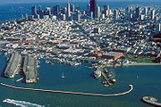
The larger waterfront area extends from the anchorage of the Golden Gate Bridge
Golden Gate Bridge
The Golden Gate Bridge is a suspension bridge spanning the Golden Gate, the opening of the San Francisco Bay into the Pacific Ocean. As part of both U.S. Route 101 and California State Route 1, the structure links the city of San Francisco, on the northern tip of the San Francisco Peninsula, to...
, along the Marina district
Marina District, San Francisco, California
The Marina District is a neighborhood located in San Francisco, California. The neighborhood sits on the site of the 1915 Panama-Pacific International Exposition, staged after the 1906 San Francisco earthquake to celebrate the reemergence of the city...
, all the way around the north and east shores of the city of San Francisco including Fisherman's Wharf and the Embarcadero, and southward to the city line just beyond Candlestick Point
Candlestick Point State Recreation Area
Candlestick Point State Recreation Area is a state park unit of California, USA, providing an urban protected area on San Francisco Bay. The park is located at the southeastern tip of San Francisco immediately south of Hunters Point and north of Sierra Point in Brisbane...
.
The Port of San Francisco is currently a semi-independent organization run by a five-member commission, appointed by the mayor
Mayor of San Francisco
The Mayor of the City and County of San Francisco is the head of the executive branch of San Francisco's city and county government. The mayor has the duty to enforce city laws, and the power to either approve or veto bills passed by the San Francisco Board of Supervisors, the legislative branch....
and approved by the Board of Supervisors
San Francisco Board of Supervisors
The San Francisco Board of Supervisors is the legislative body within the government of the City and County of San Francisco, California, United States.-Government and politics:...
.
Setting
The port area under the commission's control comprises nearly eight miles of waterfront lands, commercial real estate and maritime piers from Hyde Street on the north to India Basin in the southeast. The list of landmarks under port control include Fisherman's WharfFisherman's Wharf, San Francisco, California
Fisherman's Wharf is a neighborhood and popular tourist attraction in San Francisco, California. It roughly encompasses the northern waterfront area of San Francisco from Ghirardelli Square or Van Ness Avenue east to Pier 35 or Kearny Street...
, Pier 39
Pier 39
Pier 39 is a shopping center and popular tourist attraction built on a pier in San Francisco, California. At Pier 39, there are shops, restaurants, a video arcade, street performances, an interpretive center for the Marine Mammal Center, the Aquarium of the Bay, virtual 3D rides, and views of...
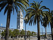
, the Ferry Building
Ferry Building
The San Francisco Ferry Building is a terminal for ferries that travel across the San Francisco Bay and a shopping center located on The Embarcadero in San Francisco, California. On top of the building is a large clock tower, which can be seen from Market Street, a main thoroughfare of the city...
, AT&T Park
AT&T Park
AT&T Park is a ballpark located in the South Beach neighborhood of San Francisco, California. Located at 24 Willie Mays Plaza, at the corner of Third and King Streets, it has served as the home of the San Francisco Giants of Major League Baseball since 2000....
(formerly SBC Park and Pacific Bell Park), located next to China Basin and Pier 70 at Potrero Point
Potrero Point
Potrero Point San Francisco is the location of the earliest and most important industrial facilities in the Western United States on the eastern extension of San Francisco's Potrero Hill, a natural land mass extending into San Francisco Bay south of Mission Bay. Potrero Point, the point of Potrero...
. Huge covered piers on piles jut out into San Francisco bay along much of the waterfront, bordered by the Embarcadero roadway.
History
The first landing place on the north-eastern tip of the San Francisco peninsula was a rocky promontory below Telegraph HillTelegraph Hill, San Francisco
Telegraph Hill refers to a neighborhood in San Francisco, California. It is one of San Francisco's 44 hills, and one of its original "Seven Hills."-Location:...
later known as Clarke's Point that jutted into the San Francisco Bay
San Francisco Bay
San Francisco Bay is a shallow, productive estuary through which water draining from approximately forty percent of California, flowing in the Sacramento and San Joaquin rivers from the Sierra Nevada mountains, enters the Pacific Ocean...
at the line of what is now Broadway and Battery Streets. Yerba Buena Cove swept inland from the subsequently named Clarke's Point to as far as Montgomery Street
Montgomery Street
Montgomery Street is a north-south thoroughfare in San Francisco, California, in the United States.It runs about 16 blocks from the Telegraph Hill neighborhood south through downtown, terminating at Market Street. South of Columbus Avenue, Montgomery Street runs through the heart of San Francisco's...
to the west, and further south and east to Rincon Point at the south of Market area at the foot of Folsom and Spear streets.
The founding padres of Mission Dolores and the other northern California missions found the jetty at Clarke's Point a convenient landing for their commerce in hides and tallow. It is the same location where Russian ships anchored to load supplies of meat and grain. Early European visitors were the British Raccoon in 1814 and the French
France
The French Republic , The French Republic , The French Republic , (commonly known as France , is a unitary semi-presidential republic in Western Europe with several overseas territories and islands located on other continents and in the Indian, Pacific, and Atlantic oceans. Metropolitan France...
frigate Artemise in 1839. The sloop USS St. Louis
USS St. Louis
USS St. Louis has been the name of more than one United States Navy ship, and may refer to:, a sloop-of-war commissioned in 1828. decommissioned in 1865, and stricken in 1907, an ironclad gunboat commissioned in 1862, later renamed Baron de Kalb, and sunk in 1863 during the American Civil War*USS St...
, which arrived in 1840, was the first warship to fly the American flag in San Francisco Bay
San Francisco Bay
San Francisco Bay is a shallow, productive estuary through which water draining from approximately forty percent of California, flowing in the Sacramento and San Joaquin rivers from the Sierra Nevada mountains, enters the Pacific Ocean...
. On July 9, 1846, the sloop USS Portsmouth gave a 21-gun salute and Captain John Berrien Montgomery and his detachment rowed ashore and hoisted the American flag on the Mexican flagpole in the small settlement's plaza, later named Portsmouth Square
Portsmouth Square
Portsmouth Square is a one-block park in Chinatown, San Francisco, California, that is bounded by Kearny Street on the east, Washington Street on the north, Clay Street on the south, and Walter Lum Place on the west....
in honor of the ship.
The earliest development of a port in San Francisco, two and a half miles east of the Presidio, was under the Mexican regime, begun in 1835 as the town of Yerba Buena
Yerba Buena (town)
Yerba Buena was the original name of San Francisco when in the Spanish Las Californias Province of New Spain, and then after 1822 in the Mexican territory of Alta California, until the Mexican American War ended with the 1848 Treaty of Guadalupe Hidalgo, when California became a territory of the...
. Before this time, the port at Monterey was considered the official port of entry to California.
Captain Richardson erected the first abode of a European on the hill overlooking the Bay. He became the first harbor master by appointment of the Governor Mariano Guadaloupe de Vallejo.
Whalers took umbrage at the taxes charged by the Mexican governor Manuel Micheltorena
Manuel Micheltorena
Manuel Micheltorena was a Brigadier General of the Mexican Army, Adjutant-General of the same, Governor, Commandant-General and Inspector of the Department of the California...
in 1843, and the outright banning of their trading in the port, then relocated from San Francisco to the Hawaiian Islands.
Commodore John D. Sloat
John D. Sloat
John Drake Sloat was a commodore in the United States Navy who, in 1846, claimed California for the United States.-Life:...
claimed California for the United States
United States
The United States of America is a federal constitutional republic comprising fifty states and a federal district...
on July 7, 1846, during the Mexican-American War, and Captain John B. Montgomery
John B. Montgomery
John Berrien Montgomery was an officer in the United States Navy who served during the Mexican-American War and the American Civil War.-Biography:...
arrived to claim Yerba Buena two days later. In 1847, the first American alcalde
Alcalde
Alcalde , or Alcalde ordinario, is the traditional Spanish municipal magistrate, who had both judicial and administrative functions. An alcalde was, in the absence of a corregidor, the presiding officer of the Castilian cabildo and judge of first instance of a town...
, Lt. Washington Allon Bartlett
Washington Allon Bartlett
Washington Allon Bartlett was the first alcalde of the American-era San Francisco serving from August 14, 1846 to January 31, 1847.-Early life and career:...
changed the name from Yerba Buena
Yerba Buena (town)
Yerba Buena was the original name of San Francisco when in the Spanish Las Californias Province of New Spain, and then after 1822 in the Mexican territory of Alta California, until the Mexican American War ended with the 1848 Treaty of Guadalupe Hidalgo, when California became a territory of the...
to San Francisco, "so that the town may have the advantage of the name given on the public map."
The United States governor of the newly occupied territory of California, General Stephen W. Kearny
Stephen W. Kearny
Stephen Watts Kearny surname also appears as Kearney in some historic sources; August 30, 1794 October 31, 1848), was one of the foremost antebellum frontier officers of the United States Army. He is remembered for his significant contributions in the Mexican-American War, especially the conquest...
, renounced the rights of eminent domain of the American government in favor of the city of San Francisco. The early city built up on the west side of Yerba Buena Cove around Portsmouth Square
Portsmouth Square
Portsmouth Square is a one-block park in Chinatown, San Francisco, California, that is bounded by Kearny Street on the east, Washington Street on the north, Clay Street on the south, and Walter Lum Place on the west....
.
Immediately, the municipality of San Francisco was given the right, by General Kearney acting as governor of California, to sell "water lots" in the tidelands between Clarke's Point and Rincon Point so the city might gain revenues from the sale. At the same time, the owner of the land at the foot of Telegraph Hill, W.S. Clarke built a timbered wharf and the location became known as Clarke's Point. Later, a substantial wharf 750 feet (229 m) long and 60 feet (18 m) wide was erected to the depth of water, 26 feet (8 m), made the landing available to deep water ships. this project was followed by other wharves built below Broadway and Clay streets, and at Commercial street.
When gold was discovered in California, the first hulk of an old iron revenue steamer, the James K. Polk, was beached at the foot of the bluff near Clarke's Point and became the foundation of the first real passenger landing in the city. It was at this site that the population of San Francisco met the Pacific mail liner the Oregon to receive the official announcement that California had been admitted to the Union. The bluff at the point was quickly leveled and on the land created a wharf was built that became the first regular berthing place, for a short time, for the Pacific mail steamships. Whatever products came to California, and whatever California produced, had to be carried by ship. In the first year of the gold rush, hundreds of ships were beached and abandoned in the tidal flats of Yerba Buena Cove, and numerous ships were run aground to become parts of the city itself. In 1853, the Vallejo Street wharf lease was granted, and a larger wharf was built.
In the ensuing years, the state legislature passed bills concerning the sale of water lots and authorizing the city to construct wharves beyond its boundary and to set wharfage rates. The battles over control of the waterfront, water lots, and docking privileges began.
The great Central Wharf was built in 1849, named for the central wharf in Boston
Boston
Boston is the capital of and largest city in Massachusetts, and is one of the oldest cities in the United States. The largest city in New England, Boston is regarded as the unofficial "Capital of New England" for its economic and cultural impact on the entire New England region. The city proper had...
, and was located where Commercial street is now. Eventually a huge forest of masts from a fleet of abandoned vessels filled Yerba Buena Cove. By 1851, the Central Wharf had ten times more business offered than it could handle, and many new wharves were struck into the bay, including those at Market, Sacramento, Washington, California, Clay, Jackson and Pacific Streets. The filling of Yerba Buena Cove and extensive corruption and legislation led to a period, during the gold rush, when major portions of the city were built on water lots, reclaimed by hook or by crook, on pile driven and rough planking overlain. Early San Francisco was a wharf city of planks and sheds and subject to devastating fires. Half the early city was built on trembling wharves and the scrub and sandy hills were not appreciated, amongst them only a few abodes and scattered tents were found. The early wharves and their buildings fell into the bay and by 1857, the waterfront was a jumble of abandoned ships and rickety piers. Businesses looked for more solid facilities.
Two wharves of notice projected out into the bay from the foot of Taylor street; McMahon's Wharf, and Meiggs Wharf. They had "T" and "L" shaped extensions, the former was a landing for wood and charcoal. The latter, after Harry Meiggs absconded, became the landing for the ferry
Ferry
A ferry is a form of transportation, usually a boat, but sometimes a ship, used to carry primarily passengers, and sometimes vehicles and cargo as well, across a body of water. Most ferries operate on regular, frequent, return services...
to Sausalito.
Merchant's (or Cousin's) Dock built and repaired ships at the site that is now Kearney and Bay streets, but it was swallowed up when a new location for the seawall was established along the cure that is now the Embarcadero. Merchant's Drydock was moved to the foot of Harrison and the company established floating drydocks at Hunter's Point. The North Point dock at the north side of Telegraph Hill was built in 1853 and became the landing site for immigrant ships from Italy and France. Numerous other wharves, privately built and owned, stretched along the northern waterfront; Flint's, the India docks, Cowell's, Shaw's, Law's, Buckelew's, Cunnigham's and the Long Wharf. Many of these wharves were on city lands that might be filled at any time, and most disappeared with the building of the seawall and the modern piers built into the early twentieth century. Amidst intense disputation over ownership and litigation unparalleled in the history of any port in the world, the establishment of the Board of State Harbor commissioners created a San Francisco waterfront as a separate institution by law, having no connection to the city government and indirectly controlled by the state.
Until the 1860s, supplies could also be delivered up Mission Creek
Mission Creek
Mission Creek is a river in San Francisco, California that has been largely culverted. The only remaining portion above ground is in the Mission Creek Channel that drains into China Basin....
by boat to the vicinity of Mission Dolores.
Seawall
The Board of State Harbor Commissioners was established in 1863 and set about the task of building a seawallSeawall
A seawall is a form of coastal defence constructed where the sea, and associated coastal processes, impact directly upon the landforms of the coast. The purpose of a seawall is to protect areas of human habitation, conservation and leisure activities from the action of tides and waves...
on the San Francisco waterfront. The project that would eliminate the patchwork and jagged lines of the waterfront, ending it cleanly at the modern Embarcadero
The Embarcadero (San Francisco)
The Embarcadero is the eastern waterfront and roadway of the Port of San Francisco, San Francisco, California, along San Francisco Bay, constructed atop an engineered seawall on reclaimed land, and derives its name from the Spanish verb embarcar, meaning "to embark"...
. After four years of litigation, the commissioners offered a thousand dollar prize for the best plan for the San Francisco Seawall. One of the designers of the plan, W.J. Lewis was appointed engineer in chief of the project. Another engineer on the project, T.J. Arnold designed the curving waterfront eventually settled on.
A 60 feet (18.3 m) pit or channel in the mudflats was dredged to a depth of 20 feet (6.1 m) below low tide level and huge loads of rock were dumped in from scows and barges at the center line of the trench until they stopped sinking, to make an evenly graded ridge the whole way at the height of mean low tide. The rocks became the foundation for the seawall. Coffer dams were sunk and forms constructed inside them while constant pumping occurred. A mass of concrete 2 foot (0.6096 m) thick and 10 feet (3 m) wide was poured over the rocks and a masonry wall seven feet at the base and nine feet high was constructed. The area inside the wall was pumped out and filled with rock, rubble and trash to the city grade. It took the board several years to acquire the leases on private wharves.
The opening of the First Transcontinental Railroad
First Transcontinental Railroad
The First Transcontinental Railroad was a railroad line built in the United States of America between 1863 and 1869 by the Central Pacific Railroad of California and the Union Pacific Railroad that connected its statutory Eastern terminus at Council Bluffs, Iowa/Omaha, Nebraska The First...
in 1869 halted harbor development and the building of the seawall. The tonnage of vessels arriving at the port dropped by nearly half in the next two years.
By 1871, the commissioners could report that they were in possession of all the wharves along the city front except those that bordered Channel Street between Third and Fourth streets.
In 1881, the harbor commissioners began contracting for the construction of the San Francisco seawall, The seawall would take fifty years before completion of the last sections in the China Basin.
Filling the downtown district
Steam powered machines called "paddiesSteam shovel
A steam shovel is a large steam-powered excavating machine designed for lifting and moving material such as rock and soil. It is the earliest type of power shovel or excavator. They played a major role in public works in the 19th and early 20th century, being key to the construction of railroads...
" were eating away at the sand dunes and rock hills, especially Telegraph Hill, a few blocks west of the filled zone. Rock was also imported from Sheep Island
Sheep Island
The following locations are known as Sheep Island:* Sheep Island, an alternate name for Brooks Island, Richmond, California* Sheep Island , Washington, United States* Sheep Island , Massachusetts, United States...
off Point Richmond. Temporary steam train lines carried the earthen fill for dumping onto the mudflats. Both the Ferry Building
Ferry Building
The San Francisco Ferry Building is a terminal for ferries that travel across the San Francisco Bay and a shopping center located on The Embarcadero in San Francisco, California. On top of the building is a large clock tower, which can be seen from Market Street, a main thoroughfare of the city...
and the Southern Pacific Building
Southern Pacific Building
The Southern Pacific Building is one of three office buildings that make up One Market Plaza along the Embarcadero in San Francisco, California. The historic 11-storey, building, also known as "The Landmark", was completed in 1916 and was incorporated into a 1976 development that includes Spear...
at the foot of Market Street were built upon thousands of Douglas-fir
Douglas-fir
Douglas-fir is one of the English common names for evergreen coniferous trees of the genus Pseudotsuga in the family Pinaceae. Other common names include Douglas tree, and Oregon pine. There are five species, two in western North America, one in Mexico, and two in eastern Asia...
piles
Deep foundation
A deep foundation is a type of foundation distinguished from shallow foundations by the depth they are embedded into the ground. There are many reasons a geotechnical engineer would recommend a deep foundation over a shallow foundation, but some of the common reasons are very large design loads, a...
, up to 135 feet (41 m) deep.
Belt Railroad
In 1890 the port commissioners began developing a series of switchyards and warehouses on the reclaimed land for use of the San Francisco Belt RailroadSan Francisco Belt Railroad
The San Francisco Belt Railroad was a short-line railroad along the Embarcadero in San Francisco, California. It began as the State Belt Railroad in 1889, and was renamed when the city bought the Port of San Francisco in 1969...
, a line of over fifty miles that connected every berth and every pier with the industrial parts of the city and railways of America with all the trade routes of the Pacific. For a decade or more, railcar ferry transfers on steamers were the means of carrying railcars to the transcontinental systems. Later, in 1912, the belt line was driven across Market Street in front of the Ferry Building to link the entire commercial waterfront with railways both south and north and across the continent. The line was extended north along Jefferson Street through the tunnel to link up with U.S. Transport Docks at Fort Mason and south to China Basin.
Modern development
According to port historian Edward Morphy, the achievement of building a great port, "was rendered possible solely by the fact that its harbor commissioners, through the succeeding of generations, not only had behind them the credit of the state of California but also were in a position to rise superior to the narrow influences of local politics... The development of the waterfront itself, the Embarcadero, the seawall and piers, the Belt Railroad and the seawall lots, could not have been carried out under private or municipal auspices in the manner so beneficial, so efficient, and so economical as is now apparent."With the fire after the 1906 earthquake
1906 San Francisco earthquake
The San Francisco earthquake of 1906 was a major earthquake that struck San Francisco, California, and the coast of Northern California at 5:12 a.m. on Wednesday, April 18, 1906. The most widely accepted estimate for the magnitude of the earthquake is a moment magnitude of 7.9; however, other...
, a new era of port development began on the San Francisco waterfront. In 1909, the San Francisco Harbor Improvement Act was passed. $9 million was allocated by the state legislature and in 1913, Islais Creek
Islais Creek
Islais Creek or Islais Creek Channel is a small creek in San Francisco, California...
and India Basin
India Basin
India Basin is the easternmost neighborhood of San Francisco, California.The parameters of India Basin are roughly the neighborhood surrounding Cargo Way, Third Street, Evans and Innes Avenues to the Hunters Point Naval Shipyard, from the top of the hill to the water.The history of India Basin is a...
lands were purchased. The Board of State Harbor Commissioners began extensive development along the waterfront, always meeting expenses from the revenues of the busy port.
Upon completion of the modern piers, odd-numbered to the north of the Ferry Building and even-numbered to the south, the port of San Francisco became the only port in the United States under a single control. The piers were leased to tenants. By the early 1920s, the port's assets were valued at $50 million and 8 to 9 million tons of merchandise and raw goods were handled yearly.
In the 1920s and 30s, numerous old piers on both sides of Market Street were razed and a smaller number of concrete piers with wider slips between them were constructed. The port also built the six-story China Basin Warehouse to bring together ships, rail, and truck for the handling of products. At India Basin, it built a plant to handle vegetable oils.
The federal government in 1922 began dredging a forty-foot channel through the Bay's outer bar in at the entrance to the harbor after 1922 and the dredging of Islais Creek with the so-called reclamation of 30 acres (121,405.8 m²) of adjacent creek tidelands.
Two graving docks at Hunter's Point that could accommodate the largest ocean-going vessels, five floating drydocks, eight marine railways, four shearleg derricks and ten floating boom derricks were available.
Los Ángeles
Los Ángeles is the capital of the province of Biobío, in the commune of the same name, in Region VIII , in the center-south of Chile. It is located between the Laja and Biobío rivers. The population is 123,445 inhabitants...
as the West Coast's largest city—and in particular, as its major industrial center—relegated the Port of San Francisco to a secondary role. For the next few decades, the port steadily but inexorably lost market share to the twins ports of Los Angeles
Port of Los Angeles
The Port of Los Angeles, also called Los Angeles Harbor and WORLDPORT L.A, is a port complex that occupies of land and water along of waterfront. The port is located on San Pedro Bay in the San Pedro neighborhood of Los Angeles, approximately south of downtown...
and -Long Beach
Port of Long Beach
The Port of Long Beach, also known as Long Beach’s Harbor Department, is the 2nd busiest container port in the USA. It adjoins the separate Port of Los Angeles. Acting as a major gateway for U.S.-Asian trade, the port occupies of land with of waterfront in the city of Long Beach, California...
, as well as its crossbay rival Port of Oakland
Port of Oakland
The Port of Oakland was the first major port on the Pacific Coast of the United States to build terminals for container ships. It is now the fifth busiest container port in the United States, behind Long Beach, Los Angeles, Newark, and Savannah...
. The advent of containerization
Containerization
Containerization is a system of freight transport based on a range of steel intermodal containers...
in the 1960s effectively sounded the death knell for the Port of San Francisco as a major marine terminal, as it had no room to expand to build a large new container handling facility like the Seventh Street Terminal at the Port of Oakland. A few piers added container handling equipment, but heavy traffic congestion in the area and poor rail access have long militated against the large-scale development of the container trade at the port. Insufficient clearances of rail tunnels and overpasses have also prevented the development of roll-on/roll-off capability at the port. With limited ability to expand physically as a result of environmentalist
Environmentalist
An environmentalist broadly supports the goals of the environmental movement, "a political and ethical movement that seeks to improve and protect the quality of the natural environment through changes to environmentally harmful human activities"...
opposition to further reclamation and the soaring cost of real estate in San Francisco, the Port of San Francisco has instead become a niche player, specializing in break bulk
Break bulk cargo
In shipping, break bulk cargo or general cargo is a term that covers a great variety of goods that must be loaded individually, and not in intermodal containers nor in bulk as with oil or grain. Ships that carry this sort of cargo are often called general cargo ships...
and dry bulk cargo
Bulk cargo
Bulk cargo is commodity cargo that is transported unpackaged in large quantities. This cargo is usually dropped or poured, with a spout or shovel bucket, as a liquid or as a mass of relatively small solids , into a bulk carrier ship's hold, railroad car, or tanker truck/trailer/semi-trailer body...
, ship repair, and ferry services.
Ferry Building
Sacramento Valley
The Sacramento Valley is the portion of the California Central Valley that lies to the north of the San Joaquin-Sacramento Delta in the U.S. state of California. It encompasses all or parts of ten counties.-Geography:...
and San Joaquin Valley
San Joaquin Valley
The San Joaquin Valley is the area of the Central Valley of California that lies south of the Sacramento – San Joaquin River Delta in Stockton...
s. Beyond were wharves for regular coastal steamers bound for Los Angeles, Portland, Seattle, British Columbia, Alaska, and ships bound for Hawaii, Central and South America and the Pacific Rim.
Pier 70

Pier 70, San Francisco, California
Pier 70 in San Francisco, California, is a historic pier in San Francisco's Potrero Point neighborhood. The pier still has its historic buildings, which housed Bethlehem Steel's administrative offices and Union Iron Works, and is currently occupied by BAE Systems Ship Repair, which once housed the...
, Potrero Point
Potrero Point
Potrero Point San Francisco is the location of the earliest and most important industrial facilities in the Western United States on the eastern extension of San Francisco's Potrero Hill, a natural land mass extending into San Francisco Bay south of Mission Bay. Potrero Point, the point of Potrero...
district on the southeast bayfront at 20th Street east of Illinois that holds the greatest example of a 19th century industrial village remaining in the western US, site of the first industrial iron and steel mills, shipbuilding and manufacturing center in California. The Union Iron Works
Union Iron Works
Union Iron Works, located in San Francisco, California, on the southeast waterfront, was a central business within the large industrial zone of Potrero Point, for four decades at the end of the nineteenth and beginning of the twentieth centuries.-History:...
and Bethlehem Shipbuilding
Bethlehem Shipbuilding
Bethlehem Sparrows Point Shipyard was founded in 1887 as Maryland Steel in Sparrows Point, Maryland. It was acquired by Bethlehem Shipbuilding Corporation in 1916 and renamed Bethlehem Sparrows Point Shipyard. The shipyard was sold in 1997 to Baltimore Marine Industries Inc....
as well as the United States Navy
United States Navy
The United States Navy is the naval warfare service branch of the United States Armed Forces and one of the seven uniformed services of the United States. The U.S. Navy is the largest in the world; its battle fleet tonnage is greater than that of the next 13 largest navies combined. The U.S...
have all had shipworks at the site. The current site is now occupied by BAE Systems Ship Repair and Sims Group
Sims Group
Sims Metal Management is a global Australian-based company that specializes in metal recycling, formerly known as Sims Group.Sims Metal Management is the world’s, as well as North America’s and Australasia’s, largest metals and electronics recycler...
.
See also
- Central Embarcadero Piers Historic District
- Pier 26, San Francisco, California