

Port of Cleveland
Encyclopedia
The Port of Cleveland is a bulk freight shipping port at the mouth of the Cuyahoga River
Cuyahoga River
The Cuyahoga River is located in Northeast Ohio in the United States. Outside of Ohio, the river is most famous for being "the river that caught fire", helping to spur the environmental movement in the late 1960s...
on Lake Erie
Lake Erie
Lake Erie is the fourth largest lake of the five Great Lakes in North America, and the tenth largest globally. It is the southernmost, shallowest, and smallest by volume of the Great Lakes and therefore also has the shortest average water residence time. It is bounded on the north by the...
and adjacent to the United States of America
United States
The United States of America is a federal constitutional republic comprising fifty states and a federal district...
city of Cleveland
Cleveland, Ohio
Cleveland is a city in the U.S. state of Ohio and is the county seat of Cuyahoga County, the most populous county in the state. The city is located in northeastern Ohio on the southern shore of Lake Erie, approximately west of the Pennsylvania border...
, in Cuyahoga County
Cuyahoga County, Ohio
Cuyahoga County is a county located in the state of Ohio, United States. It is the most populous county in Ohio; as of the 2010 census, the population was 1,280,122. Its county seat is Cleveland. Cuyahoga County is part of Greater Cleveland, a metropolitan area, and Northeast Ohio, a...
, Ohio
Ohio
Ohio is a Midwestern state in the United States. The 34th largest state by area in the U.S.,it is the 7th‑most populous with over 11.5 million residents, containing several major American cities and seven metropolitan areas with populations of 500,000 or more.The state's capital is Columbus...
.
It is the third-largest port in the Great Lakes
Great Lakes
The Great Lakes are a collection of freshwater lakes located in northeastern North America, on the Canada – United States border. Consisting of Lakes Superior, Michigan, Huron, Erie, and Ontario, they form the largest group of freshwater lakes on Earth by total surface, coming in second by volume...
, the fourth-largest Great Lakes port by annual tonnage.
Cargo
The Port of Cleveland handles the bulk of raw material shipments for regional manufacturing, as well as exporting some local resources (salt mined from under Lake Erie, materials quarried locally, Ohio farm surpluses, ...).Primary Cargoes
- Inbound: Steel, heavy machinery, liquid/dry bulk
- Outbound: machinery and steel
Overall Annual Tonnage
- Generating $1 billion ($1,000,000,000.00 USDUnited States dollarThe United States dollar , also referred to as the American dollar, is the official currency of the United States of America. It is divided into 100 smaller units called cents or pennies....
) per year in trade. - Annual cargo handling averages between 11 million to 16 million tons
- Dry Bulk (loose materials such as limestone and grain): 12 million tons
- Break Bulk (packaged materials): 500,000 tons
- about 1,000 vessel visits,
| Year |
U.S. United States The United States of America is a federal constitutional republic comprising fifty states and a federal district... Rank |
Total Ton Ton The ton is a unit of measure. It has a long history and has acquired a number of meanings and uses over the years. It is used principally as a unit of weight, and as a unit of volume. It can also be used as a measure of energy, for truck classification, or as a colloquial term.It is derived from... s |
Domestic Ton Ton The ton is a unit of measure. It has a long history and has acquired a number of meanings and uses over the years. It is used principally as a unit of weight, and as a unit of volume. It can also be used as a measure of energy, for truck classification, or as a colloquial term.It is derived from... s |
Foreign Total Ton Ton The ton is a unit of measure. It has a long history and has acquired a number of meanings and uses over the years. It is used principally as a unit of weight, and as a unit of volume. It can also be used as a measure of energy, for truck classification, or as a colloquial term.It is derived from... s |
Foreign Imports Ton Ton The ton is a unit of measure. It has a long history and has acquired a number of meanings and uses over the years. It is used principally as a unit of weight, and as a unit of volume. It can also be used as a measure of energy, for truck classification, or as a colloquial term.It is derived from... s |
Foreign Exports Ton Ton The ton is a unit of measure. It has a long history and has acquired a number of meanings and uses over the years. It is used principally as a unit of weight, and as a unit of volume. It can also be used as a measure of energy, for truck classification, or as a colloquial term.It is derived from... s |
Reference |
|---|---|---|---|---|---|---|---|
| 2006 | 44 | 15,186,819 | 11,467,131 | 3,719,688 | 3,598,998 | 120,690 | |
| 2005 | 47 | 13,640,966 | 10,225,360 | 3,415,606 | 3,137,262 | 278,344 | |
| 2004 | 44 | 15,774,611 | 11,855,282 | 3,919,329 | 3,567,866 | 351,463 | |
| 2003 | 47 | 12,620,794 | 9,508,542 | 3,112,252 | 2,708,093 | 404,159 | |
| 2002 | 48 | 11,411,765 | 9,083,965 | 2,327,800 | 2,270,800 | 57,000 | |
| 2001 | 48 | 11,937,815 | 9,203,587 | 2,734,228 | 2,430,028 | 304,200 | |
| 2000 | 44 | 14,390,802 | 11,914,437 | 2,476,365 | 2,262,104 | 214,261 | |
| Year |
Dry Bulk short Ton Ton The ton is a unit of measure. It has a long history and has acquired a number of meanings and uses over the years. It is used principally as a unit of weight, and as a unit of volume. It can also be used as a measure of energy, for truck classification, or as a colloquial term.It is derived from... s |
Break Bulk short Ton Ton The ton is a unit of measure. It has a long history and has acquired a number of meanings and uses over the years. It is used principally as a unit of weight, and as a unit of volume. It can also be used as a measure of energy, for truck classification, or as a colloquial term.It is derived from... s |
|---|---|---|
| 2000 | 1,028,500 | 949,552 |
| 1999 | 934,306 | 721,369 |
| 1998 | 1,239,551 | 1,182,792 |
| 1997 | 1,521,729 | 1,045,377 |
| 1996 | 1,809,000 | 1,158,056 |
| 1995 | 1,531,985 | 779,314 |
| 1994 | 1,899,989 | 869,669 |
| 1993 | 2,069,184 | 764,743 |
| 1992 | 2,700,842 | 435,286 |
| 1991 | 2,852,675 | 913,670 |
| 1990 | 3,038,535 | 773,922 |
Rail
Connections to:(2) Class I railroad
Class I railroad
A Class I railroad in the United States and Mexico, or a Class I rail carrier in Canada, is a large freight railroad company, as classified based on operating revenue.Smaller railroads are classified as Class II and Class III...
s:
- CSX TransportationCSX TransportationCSX Transportation operates a Class I railroad in the United States known as the CSX Railroad. It is the main subsidiary of the CSX Corporation. The company is headquartered in Jacksonville, Florida, and owns approximately 21,000 route miles...
- Norfolk Southern RailwayNorfolk Southern RailwayThe Norfolk Southern Railway is a Class I railroad in the United States, owned by the Norfolk Southern Corporation. With headquarters in Norfolk, Virginia, the company operates 21,500 route miles in 22 eastern states, the District of Columbia and the province of Ontario, Canada...
and several regional
Regional railroad
In the United States, a regional railroad is a railroad company that is not Class I, but still has a substantial amount of traffic or trackage . The Association of American Railroads has defined the lower bound as of track or $40 million in annual operating revenue...
/short-line railroads:
- Cleveland Terminal and Valley Railway
- Cleveland Works Railway
- Cuyahoga Valley Railway
- Flats Industrial RailroadFlats Industrial RailroadThe Flats Industrial Railroad is a Class III railroad that provides short-line commercial/industrial switching service in Cleveland, Cuyahoga County, Ohio, primarily with CSX Transportation and the Norfolk Southern Railway.- History :...
- ISG Railways
- Newburgh and South Shore RailroadNewburgh and South Shore RailroadThe Newburg & South Shore Railroad is a railroad that operates in Cleveland, Ohio. The line operates on 13 miles of railroad track. It was originally built to service U.S. Steel mills in Cleveland. The line is owned by Omnitrax....
- R.J. Corman Railroad/Cleveland Line
- Wheeling and Lake Erie Railway
Truck
Port has truck access to four major Interstate highways: I-71Interstate 71Interstate 71 is an Interstate Highway in the Great Lakes/Midwestern and Southeastern region of the United States. Its southern terminus is at an interchange with Interstate 64 and Interstate 65 in Louisville, Kentucky. Its northern terminus is at an interchange with Interstate 90 in Cleveland,...
, South to: StrongsvilleStrongsville, OhioAs of the census of 2000, there were 43,858 people, 16,209 households, and 12,383 families residing in the city. The population density was 1,779.6 people per square mile . There were 16,863 housing units at an average density of 684.2 per square mile...
, SevilleSeville, OhioSeville is a village in Medina County, Ohio, United States. The population was 2,160 at the 2000 census.-Geography:Seville is located at .According to the United States Census Bureau, the village has a total area of , all land....
, ColumbusColumbus, OhioColumbus is the capital of and the largest city in the U.S. state of Ohio. The broader metropolitan area encompasses several counties and is the third largest in Ohio behind those of Cleveland and Cincinnati. Columbus is the third largest city in the American Midwest, and the fifteenth largest city...
and CincinnatiCincinnati, OhioCincinnati is a city in the U.S. state of Ohio. Cincinnati is the county seat of Hamilton County. Settled in 1788, the city is located to north of the Ohio River at the Ohio-Kentucky border, near Indiana. The population within city limits is 296,943 according to the 2010 census, making it Ohio's... I-77Interstate 77Interstate 77 is an Interstate Highway in the eastern United States. It traverses diverse terrain, from the mountainous state of West Virginia to the rolling farmlands of North Carolina and Ohio. It largely supplants the old U.S...
, South to: RichfieldRichfield, OhioRichfield is a village in Summit County, Ohio, United States. The population was 3,286 at the 2000 census. The village and the adjacent Richfield Township are approximately equidistant between the downtown areas of Akron and Cleveland...
, CambridgeCambridge, OhioAs of the census of 2000, there were 11,520 people, 4,924 households, and 2,954 families residing in the city. The population density was 2,055.1 people per square mile . There were 5,585 housing units of an average density of 996.3 per square mile...
; Beckley, West VirginiaBeckley, West VirginiaBeckley is a city in Raleigh County, West Virginia, United States, which was founded on April 4, 1838. The 2008 population was estimated to be 16,832 by the U.S. Census Bureau. Early in its history, the town was known as Beckleyville and Raleigh Court House...
and Columbia, South CarolinaColumbia, South CarolinaColumbia is the state capital and largest city in the U.S. state of South Carolina. The population was 129,272 according to the 2010 census. Columbia is the county seat of Richland County, but a portion of the city extends into neighboring Lexington County. The city is the center of a metropolitan...
 I-80Interstate 80Interstate 80 is the second-longest Interstate Highway in the United States, following Interstate 90. It is a transcontinental artery running from downtown San Francisco, California to Teaneck, New Jersey in the New York City Metropolitan Area...
/Ohio TurnpikeOhio TurnpikeThe Ohio Turnpike, officially the James W. Shocknessy Ohio Turnpike, is a -long, limited-access toll highway in the U.S. state of Ohio, serving as a primary corridor to Chicago and Pittsburgh...
,- East to: AkronAkron, OhioAkron , is the fifth largest city in the U.S. state of Ohio and the county seat of Summit County. It is located in the Great Lakes region approximately south of Lake Erie along the Little Cuyahoga River. As of the 2010 census, the city had a population of 199,110. The Akron Metropolitan...
, StreetsboroStreetsboro, OhioStreetsboro is a city in Portage County, Ohio, United States. It is formed from the former township of Streetsboro, which was formed from the Connecticut Western Reserve. It is nearly co-extant with the former Streetsboro Township; the village of Sugar Bush Knolls was also formed in part from a...
, YoungstownYoungstown, OhioYoungstown is a city in the U.S. state of Ohio and the county seat of Mahoning County; it also extends into Trumbull County. The municipality is situated on the Mahoning River, approximately southeast of Cleveland and northwest of Pittsburgh, Pennsylvania...
; and Pennsylvania TurnpikePennsylvania TurnpikeThe Pennsylvania Turnpike is a toll highway system operated by the Pennsylvania Turnpike Commission in the Commonwealth of Pennsylvania, United States. The three sections of the turnpike system total . The main section extends from Ohio to New Jersey and is long... - West to: North RidgevilleNorth Ridgeville, OhioNorth Ridgeville,is a city located along the eastern border of Lorain County, Ohio, United States. The city's population was 29,465 at the 2010 census. A west side suburb of Cleveland, North Ridgeville is the number 1 fastest growing city in the entire Greater Cleveland area.Located from Cleveland...
, LorainLorain, OhioLorain is a city in Lorain County, Ohio, United States. The municipality is located in northeastern Ohio on Lake Erie, at the mouth of the Black River, about 30 miles west of Cleveland....
, ToledoToledo, OhioToledo is the fourth most populous city in the U.S. state of Ohio and is the county seat of Lucas County. Toledo is in northwest Ohio, on the western end of Lake Erie, and borders the State of Michigan...
; and Indiana Toll RoadIndiana Toll RoadThe Indiana Toll Road, officially the Indiana East–West Toll Road, is a toll road that runs for east–west across northern Indiana from the Illinois state line to the Ohio state line...  I-90Interstate 90Interstate 90 is the longest Interstate Highway in the United States at . It is the northernmost coast-to-coast interstate, and parallels US 20 for the most part. Its western terminus is in Seattle, at Edgar Martinez Drive S. near Safeco Field and CenturyLink Field, and its eastern terminus is in...
,- East to: Euclid, OhioEuclid, OhioEuclid is a city in Cuyahoga County, Ohio, United States. It is part of the Greater Cleveland Metropolitan Area, and borders Cleveland. As of the 2010 census, the city had a total population of 48,920...
, WilloughbyWilloughby, OhioAs of the census of 2000, there were 22,621 people, 10,265 households, and 5,892 families residing in the city. The population density was 2,225.3 people per square mile . There were 10,700 housing units at an average density of 1,052.6 per square mile...
; Erie, PennsylvaniaErie, PennsylvaniaErie is a city located in northwestern Pennsylvania in the United States. Named for the lake and the Native American tribe that resided along its southern shore, Erie is the state's fourth-largest city , with a population of 102,000...
and Buffalo, New YorkBuffalo, New YorkBuffalo is the second most populous city in the state of New York, after New York City. Located in Western New York on the eastern shores of Lake Erie and at the head of the Niagara River across from Fort Erie, Ontario, Buffalo is the seat of Erie County and the principal city of the... - West to: WestlakeWestlake, OhioWestlake is a city in Cuyahoga County, Ohio, United States. The population was 32,729 at the 2010 census. It is an affluent suburb of Cleveland, Ohio and is located 12 miles from Cleveland's downtown.-Geography:Westlake is located at...
, ElyriaElyria, Ohio-Community:Elyria has an extensive, although financially burdened, community food pantry and "Hot Meals" program administered through the Second Harvest Food Bank and several churches Elyria is served by Elyria Memorial Hospital.-Recreation and parks:...
, ToledoToledo, OhioToledo is the fourth most populous city in the U.S. state of Ohio and is the county seat of Lucas County. Toledo is in northwest Ohio, on the western end of Lake Erie, and borders the State of Michigan...
; and South Bend, IndianaSouth Bend, IndianaThe city of South Bend is the county seat of St. Joseph County, Indiana, United States, on the St. Joseph River near its southernmost bend, from which it derives its name. As of the 2010 Census, the city had a total of 101,168 residents; its Metropolitan Statistical Area had a population of 316,663...
as well as local bypasses/connectors:
 I-271Interstate 271Interstate 271 is an auxiliary interstate highway in the suburbs of Cleveland and Akron in the U.S. state of Ohio. The highway is officially designated the "Cleveland Outerbelt East", but rarely referred to by that name.-Route description:...
, I-480Interstate 480 (Ohio)Interstate 480 is a loop highway that connects the Ohio Turnpike with suburban Cleveland, Ohio. The highway is officially designated the Outerbelt South Freeway, but it is rarely referred to by that name....
, and I-490Interstate 490 (Ohio)Interstate 490 is a Interstate Highway in Cleveland, Ohio. The western terminus is a junction with I-90 and I-71 on Cleveland's west side. After spanning the Cuyahoga River, the eastern terminus is a junction with East 55th Street, just east of I-77....
;
and Ohio State Routes, such as:
 Ohio State Route 2
- East to: EuclidEuclid, OhioEuclid is a city in Cuyahoga County, Ohio, United States. It is part of the Greater Cleveland Metropolitan Area, and borders Cleveland. As of the 2010 census, the city had a total population of 48,920...
and PainesvillePainesville, OhioAs of the 2010 Census, there were 19,563 people. As of the census of 2000, there were 17,503 people, 6,525 households, and 4,032 families residing in the city. The population density was 2,928.6 people per square mile . There were 6,933 housing units at an average density of 1,160.0 per square mile... - West to: Rocky RiverRocky River, OhioRocky River is an affluent western suburb of Cleveland, Ohio, United States located in Cuyahoga County approximately nine miles west of Public Square in downtown Cleveland. The city is named for the river that forms its eastern border...
and ElyriaElyria, Ohio-Community:Elyria has an extensive, although financially burdened, community food pantry and "Hot Meals" program administered through the Second Harvest Food Bank and several churches Elyria is served by Elyria Memorial Hospital.-Recreation and parks:...
Facilities
Lake Erie
Lake Erie is the fourth largest lake of the five Great Lakes in North America, and the tenth largest globally. It is the southernmost, shallowest, and smallest by volume of the Great Lakes and therefore also has the shortest average water residence time. It is bounded on the north by the...
on the east side of the Cuyahoga River
Cuyahoga River
The Cuyahoga River is located in Northeast Ohio in the United States. Outside of Ohio, the river is most famous for being "the river that caught fire", helping to spur the environmental movement in the late 1960s...
, while the Cleveland Bulk Terminal transshipment facility occupies 44 acre (0.17806184 km²) just west of the river.
Geography
The Port of Cleveland spans across the Cleveland Harbor on Lake ErieLake Erie
Lake Erie is the fourth largest lake of the five Great Lakes in North America, and the tenth largest globally. It is the southernmost, shallowest, and smallest by volume of the Great Lakes and therefore also has the shortest average water residence time. It is bounded on the north by the...
and up the Cuyahoga River
Cuyahoga River
The Cuyahoga River is located in Northeast Ohio in the United States. Outside of Ohio, the river is most famous for being "the river that caught fire", helping to spur the environmental movement in the late 1960s...
to the Turning Basin.
| Name |
USGS United States Geological Survey The United States Geological Survey is a scientific agency of the United States government. The scientists of the USGS study the landscape of the United States, its natural resources, and the natural hazards that threaten it. The organization has four major science disciplines, concerning biology,... GNIS Geographic Names Information System The Geographic Names Information System is a database that contains name and locative information about more than two million physical and cultural features located throughout the United States of America and its territories. It is a type of gazetteer... Feature ID # and Link Hyperlink In computing, a hyperlink is a reference to data that the reader can directly follow, or that is followed automatically. A hyperlink points to a whole document or to a specific element within a document. Hypertext is text with hyperlinks... |
Coordinates Geographic coordinate system A geographic coordinate system is a coordinate system that enables every location on the Earth to be specified by a set of numbers. The coordinates are often chosen such that one of the numbers represent vertical position, and two or three of the numbers represent horizontal position... |
Elevation Elevation The elevation of a geographic location is its height above a fixed reference point, most commonly a reference geoid, a mathematical model of the Earth's sea level as an equipotential gravitational surface .... |
|---|---|---|---|
| Cleveland Harbor | [ 1072326] | 41°31′10"N 81°41′19"W | 571 feet (174 m) |
| Cuyahoga River Cuyahoga River The Cuyahoga River is located in Northeast Ohio in the United States. Outside of Ohio, the river is most famous for being "the river that caught fire", helping to spur the environmental movement in the late 1960s... |
[ 1072205] | 41°30′13"N 81°42′44"W | 571 feet (174 m) |
| Turning Basin | [ 1047220] | 41°28′36"N 81°40′20"W | 581 feet (177.1 m) |
Maritime
Docks are maintained at a full Great LakesGreat Lakes
The Great Lakes are a collection of freshwater lakes located in northeastern North America, on the Canada – United States border. Consisting of Lakes Superior, Michigan, Huron, Erie, and Ontario, they form the largest group of freshwater lakes on Earth by total surface, coming in second by volume...
seaway depth, which is 27 feet (8.2 m).
Operators
Four terminal operators use port facilities:- Carmeuse NA
- Essroc (ItalcementiItalcementiItalcementi is an Italian multinational company, quoted on the Borsa Italiana, which produces cement, ready-mix concrete and construction aggregates...
) - Kenmore Construction
- Federal Marine Terminals, Inc.Fednav GroupFednav Group is a group of seven Canadian companies in the Ship transport industry. Primarily involved in transporting bulk cargo and break bulk cargo worldwide, the group is also involved in vessel servicing and cargo handling....
Cleveland Bulk Terminal
Cleveland Bulk Terminal (CBT), located at 5500 Whiskey Island Drive, on Whiskey Island, is port-owned but operated by Carmeuse NA which handles iron ore transfers. The lakefront facility can accommodate 1000 feet (304.8 m) vessels used to discharge and reload rail cars. The automated CBT iron ore loader system on Whiskey Island on the west side of the Cuyahoga RiverCuyahoga River
The Cuyahoga River is located in Northeast Ohio in the United States. Outside of Ohio, the river is most famous for being "the river that caught fire", helping to spur the environmental movement in the late 1960s...
loads materials onto boats from the terminal and transfers materials at a rate of 5,200 tons per hour. Limited handling of materials greatly improves the quality of pellets delivered to the mill.
The ore loader operation benefits three Cleveland
Cleveland, Ohio
Cleveland is a city in the U.S. state of Ohio and is the county seat of Cuyahoga County, the most populous county in the state. The city is located in northeastern Ohio on the southern shore of Lake Erie, approximately west of the Pennsylvania border...
companies:
- Cleveland-CliffsCleveland-CliffsCliffs Natural Resources , formerly Cleveland-Cliffs, is a Cleveland, Ohio business firm that specializes in the mining and beneficiation of iron ore and the mining of coal. The firm is an independent company whose shares are traded on the New York Stock Exchange. The firm has stated that it had...
—supplier of iron ore pellets - Mittal Steel CompanyMittal Steel CompanyMittal Steel Company N.V. was one of the world's largest steel producers by volume, and also one of the largests in turnover. The company is now part of ArcelorMittal....
—uses the pellets at its mills - Carmeuse NA—CBT operator and materials transporter
Terminals
These facilities are:- nine berths and docks in either open dock or two-berth facilities
- capacity for lifting up to 150 net tons
- direct rail access and warehousing ability
- over 6500 feet (1,981.2 m) of linear dock space, of warehouse space and of open storage for general cargo operations.
| Dock |
Coordinates Geographic coordinate system A geographic coordinate system is a coordinate system that enables every location on the Earth to be specified by a set of numbers. The coordinates are often chosen such that one of the numbers represent vertical position, and two or three of the numbers represent horizontal position... |
Berth Length |
Warehouse Storage |
Facilities |
Tenants |
|---|---|---|---|---|---|
| 20 | 41°30′6.91"N 81°42′35.70"W | 1200 feet (365.8 m) | dry bulk, outside storage, cement | Essroc (Italcementi Italcementi Italcementi is an Italian multinational company, quoted on the Borsa Italiana, which produces cement, ready-mix concrete and construction aggregates... Group) and Kenmore Construction |
|
| 22 | 41°30′14.95"N 81°42′27.41"W | 760 feet (231.6 m) | Federal Marine Terminals, Inc. Fednav Group Fednav Group is a group of seven Canadian companies in the Ship transport industry. Primarily involved in transporting bulk cargo and break bulk cargo worldwide, the group is also involved in vessel servicing and cargo handling.... |
||
| 24 | 24: 41°30′17.80"N 81°42′19.25"W A: 41°30′12.01"N 81°42′13.80"W |
1900 feet (579.1 m) | 24: 79000 ft2 A: 144000 ft2 |
30-ton overhead cranes | Federal Marine Terminals, Inc. Fednav Group Fednav Group is a group of seven Canadian companies in the Ship transport industry. Primarily involved in transporting bulk cargo and break bulk cargo worldwide, the group is also involved in vessel servicing and cargo handling.... |
| 26 | 41°30′22.44"N 81°42′14.39"W | 1677 feet (511.1 m) | 26: 76000 ft2 | Federal Marine Terminals, Inc. Fednav Group Fednav Group is a group of seven Canadian companies in the Ship transport industry. Primarily involved in transporting bulk cargo and break bulk cargo worldwide, the group is also involved in vessel servicing and cargo handling.... |
|
| 28 | 41°30′23.81"N 81°42′10.22"W | 1243 feet (378.9 m) | Buckeye Booster: heavy 150-ton capacity lift crane | Federal Marine Terminals, Inc. Fednav Group Fednav Group is a group of seven Canadian companies in the Ship transport industry. Primarily involved in transporting bulk cargo and break bulk cargo worldwide, the group is also involved in vessel servicing and cargo handling.... |
|
| 30 | 41°30′30.55"N 81°42′3.23"W | 500 feet (152.4 m) | 54000 ft2 | Federal Marine Terminals, Inc. Fednav Group Fednav Group is a group of seven Canadian companies in the Ship transport industry. Primarily involved in transporting bulk cargo and break bulk cargo worldwide, the group is also involved in vessel servicing and cargo handling.... |
|
| 32 | 41°30′32.65"N 81°41′59.53"W | City of Cleveland, Ohio Cleveland, Ohio Cleveland is a city in the U.S. state of Ohio and is the county seat of Cuyahoga County, the most populous county in the state. The city is located in northeastern Ohio on the southern shore of Lake Erie, approximately west of the Pennsylvania border... used for non-Maritime development including the new Lake Shore Electric Railway Lake Shore Electric Railway (museum) The Lake Shore Electric Railway was an attempt to start an electric railway museum in Cleveland, OhioThe former Trolleyville USA museum in Olmsted Township closed down in 2005. At that time, organizers sought to relocate the museum's collection of 31 trolley cars... interurban museum (since 2006). |
|||
| CBT | 41°29′50.24"N 81°43′16.73"W | 1850 feet (563.9 m) | Outside storage: 46 acre |
Carmeuse NA | |
| Totals | ft | ft2 | |||
Foreign Trade Zones
ClevelandCleveland, Ohio
Cleveland is a city in the U.S. state of Ohio and is the county seat of Cuyahoga County, the most populous county in the state. The city is located in northeastern Ohio on the southern shore of Lake Erie, approximately west of the Pennsylvania border...
-Cuyahoga County
Cuyahoga County, Ohio
Cuyahoga County is a county located in the state of Ohio, United States. It is the most populous county in Ohio; as of the 2010 census, the population was 1,280,122. Its county seat is Cleveland. Cuyahoga County is part of Greater Cleveland, a metropolitan area, and Northeast Ohio, a...
Port Authority, Grantee #40, operates-owns several General Purpose Zone Foreign Trade Zone
Free port
A free port or free zone , sometimes also called a bonded area is a port, port area or other area with relaxed jurisdiction with respect to the country of location...
s in Cuyahoga County
Cuyahoga County, Ohio
Cuyahoga County is a county located in the state of Ohio, United States. It is the most populous county in Ohio; as of the 2010 census, the population was 1,280,122. Its county seat is Cleveland. Cuyahoga County is part of Greater Cleveland, a metropolitan area, and Northeast Ohio, a...
, Ashtabula County
Ashtabula County, Ohio
Ashtabula County is the northeasternmost county in the state of Ohio. As of 2010, the population was 101,497, its county seat is Jefferson. The county is named for a Native American word meaning "river of many fish"....
and Lorain County
Lorain County, Ohio
Lorain County is a county located in the U.S. state of Ohio, and is considered to be a part of what is locally referred to as Greater Cleveland. As of the 2010 census, its population was 301,356. an increase from 284,664 in 2000...
.
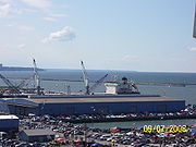
Port of Cleveland
Port of Cleveland complex located on Lake ErieLake Erie
Lake Erie is the fourth largest lake of the five Great Lakes in North America, and the tenth largest globally. It is the southernmost, shallowest, and smallest by volume of the Great Lakes and therefore also has the shortest average water residence time. It is bounded on the north by the...
at the mouth of the Cuyahoga River
Cuyahoga River
The Cuyahoga River is located in Northeast Ohio in the United States. Outside of Ohio, the river is most famous for being "the river that caught fire", helping to spur the environmental movement in the late 1960s...
includes five general cargo facilities operated by port-approved stevedoring contractors.
Tow Path Valley Business Park
Tow Path Valley Business Park is located on both sides of the east and west bank of the Cuyahoga RiverCuyahoga River
The Cuyahoga River is located in Northeast Ohio in the United States. Outside of Ohio, the river is most famous for being "the river that caught fire", helping to spur the environmental movement in the late 1960s...
bordered by Jennings Road on the south, Upper Campbell Road on the east, I-490/I-77/Dille Road on the north and West 14th Street to the west.