
Pointe aux Barques Light
Encyclopedia
The Pointe aux Barques Lighthouse ranks among the ten oldest lighthouses in Michigan. It is an active lighthouse
maintained by the US Coast Guard remotely, located in Lighthouse County Park on Lake Huron
near Port Hope, Michigan
in Huron County
. "Pointe aux Barques" means 'Point of Little Boats', a descriptor of the shallow shoal
s and reef
s that lurk beneath these waves, presenting a hazard to boats as they round Michigan's Thumb
.
. Navigation was still primitive by today’s standards. Vessels followed the coastline of the lakes until there was a need to cross a large body of water, and then a compass and sextant were the major navigation tools.
Sailing schooners left Detroit and the St. Clair River
and soon left the sight of the 1825 Fort Gratiot Light and began the perilous trip north along the Lake Huron
shore. The next light to the north was located at Thunder Bay Island
(1832), more than 150 miles (241.4 km) north of Fort Gratiot
. Any vessel sailing up the Lake Huron
coast stood a good chance of running aground on the reef extending out from Pointe aux Barques. The reef is only covered by some two feet of water and stuck out nearly two miles into Lake Huron.
Pointe aux Barques was also used as a turning point for vessels destined to the Saginaw River
. Range lights had been established at the mouth of the Saginaw River
as early as 1841, but the trip to Saginaw Bay
required steering clear of Pointe aux Barques reef.
The lighthouse was intended to be constructed near the Thumb's
most northwestern point at Pointe Aux Barques
however it was ultimately constructed approximately 4.5 miles (7.2 km) east / southeast in what is now Huron Township.
President James K. Polk
appropriated $5,000 to build the first lighthouse structure on July 3, 1847. The first keeper, Peter Shook, and his family moved in in 1848. In 1849 the keeper's dwelling burned to the ground. The first light tower was built on this location in 1847, at a cost of $5,000. It was first lit for the 1848 shipping season. The tower was poorly constructed and needed to be replaced after only 10 years.
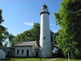
The present 1857 light is a conical white brick tower, 89 feet (27.1 m) tall, with a focal plane of 93 feet (28.3 m) above Lake Huron. A rotating Third Order Fresnel lens
provided a flash every two minutes visible as far as 16 miles (25.7 km) out on the lake. The tower is attached to a 2-story, brick keeper’s dwelling by a matching brick passageway.
The new taller light tower helped guide vessels away from the hazardous reef, but wrecks continued to occur. In 1875 a United States Life Saving Service station was built just south of the lighthouse.
An assistant keeper's house was added in 1908, and the light was upgraded to an incandescent vapor lamp in 1914. The change increased the lights range to 18 miles (29 km) over the lake, and further protection was added in 1918 with the addition of a lighted, bell buoy some two and a quarter miles off shore at the end of the point.
Electrification came to Point aux Barques in 1932 and the incandescent light bulb in the Third Order lens with bull's-eyes provided an output of 120,000 candlepower. The Coast Guard
assumed responsibility for the nation's aids to navigation in 1939, and the way was paved for complete automation. The signal was further improved around 1950 with the removal of the Fresnel lens
and the installation of rotating DCB-224
aero beacons rated at 1,000,000 candlepower. Putting aside questions of nostalgia, aesthetics, or appreciation for the engineering of a bygone era (as exemplified by the Fresnel lens), this iteration of lighthouse illumination is itself incredibly effective, and an endangered remnant of another bygone era.
The State Historic Preservation Office, which administers the Michigan Historical Marker Program, awarded a $31,000 Michigan Lighthouse Assistance Grant to the county for a historic structures report and plans and specifications for the restoration of the lighthouse. The Michigan Lighthouse Assistance Grant is funded through the sale of the "Save our Lights" specialty license plates. The county received an additional $70,000 CMI (Clean Michigan Initiative) grant from the Department of Environmental Quality for restoration.
Since the Michigan Historical Marker Program began in 1955, the Michigan Historical Commission has placed more than 1,500 markers throughout the state. The markers are paid for with donations from sponsors who submit application packages to the State Historic Preservation Office. The Michigan Historical Commission determines the placement and wording of official state markers which are the property of the State of Michigan. The Pointe Aux Barques Lighthouse Society donated the $2,875 for the marker.
The text on the Historical Marker reads as follows:
Following automation, the lighthouse grounds were turned over to Huron County. The transfer was completed in June, 2003. The tower is an active aid to navigation and is not open to the public. A camp ground was established near the light station in the area where an 1876 United States Life Saving Service (USLSS) station had been located.
A group of students from Western Michigan University
performed an archeological dig at the site in 2003. They unearthed evidence of a 1840s lighthouse structure that preceded the 1857 building. It was also repaired extensively in 2005.
In 1972, the lighthouse was listed in the National Register of Historic Places
, Reference #73000949. On site are two museums,namely - "THE KEEPERS OF THE LIGHT" and "THE THUMB UNDERWATER PRESERVE". The original Third Order Fresnel lens
, from Pointe aux Barques, is on display at the museum in Huron City.
The Pointe aux Barques Lighthouse Society (PaBLS), founded in 2002, is dedicated to preserving and restoring the light station and museum located inside.
In 2008, an exterior historical restoration project was successfully completed by National Restoration, Inc.
 M-25
M-25
, seven miles (11 km) north of Port Hope
and eleven miles (18 km) south of Port Austin
on Lighthouse Road. It is a Huron County park. A campground is located adjacent to the base of the light. Visitors can easily spend the better part of a day touring the lighthouse grounds and museum or just enjoying the beauty of the Lake Huron shore.

Lighthouse
A lighthouse is a tower, building, or other type of structure designed to emit light from a system of lamps and lenses or, in older times, from a fire, and used as an aid to navigation for maritime pilots at sea or on inland waterways....
maintained by the US Coast Guard remotely, located in Lighthouse County Park on Lake Huron
Lake Huron
Lake Huron is one of the five Great Lakes of North America. Hydrologically, it comprises the larger portion of Lake Michigan-Huron. It is bounded on the east by the Canadian province of Ontario and on the west by the state of Michigan in the United States...
near Port Hope, Michigan
Port Hope, Michigan
Port Hope is a village in Huron County of the U.S. state of Michigan. As of the 2000 census, the village population was 310. The village is within Rubicon Township.-Geography:...
in Huron County
Huron County, Michigan
-Highways:* M-19* M-25* M-53* M-142-Demographics:As of the census of 2000, there were 36,079 people, 14,597 households, and 10,144 families residing in the county. The population density was 43 people per square mile . There were 20,430 housing units at an average density of 24 per square mile...
. "Pointe aux Barques" means 'Point of Little Boats', a descriptor of the shallow shoal
Shoal
Shoal, shoals or shoaling may mean:* Shoal, a sandbank or reef creating shallow water, especially where it forms a hazard to shipping* Shoal draught , of a boat with shallow draught which can pass over some shoals: see Draft...
s and reef
Reef
In nautical terminology, a reef is a rock, sandbar, or other feature lying beneath the surface of the water ....
s that lurk beneath these waves, presenting a hazard to boats as they round Michigan's Thumb
The Thumb
The Thumb is a region and a peninsula of Michigan, so named because the Lower Peninsula is shaped like a mitten; thus the Thumb is the area that looks like the thumb of the mitten. The Thumb is generally considered to be in the Mid-Michigan area of the state, located east of Flint/Tri-Cities...
.
History
In the mid-19th century most travel was by sailing vessel. There were few or no roads, and only a few steamships were operating on the Great LakesGreat Lakes
The Great Lakes are a collection of freshwater lakes located in northeastern North America, on the Canada – United States border. Consisting of Lakes Superior, Michigan, Huron, Erie, and Ontario, they form the largest group of freshwater lakes on Earth by total surface, coming in second by volume...
. Navigation was still primitive by today’s standards. Vessels followed the coastline of the lakes until there was a need to cross a large body of water, and then a compass and sextant were the major navigation tools.
Sailing schooners left Detroit and the St. Clair River
St. Clair River
The St. Clair River is a river in central North America which drains Lake Huron into Lake St Clair, forming part of the international boundary between the Canadian province of Ontario and the U.S. state of Michigan...
and soon left the sight of the 1825 Fort Gratiot Light and began the perilous trip north along the Lake Huron
Lake Huron
Lake Huron is one of the five Great Lakes of North America. Hydrologically, it comprises the larger portion of Lake Michigan-Huron. It is bounded on the east by the Canadian province of Ontario and on the west by the state of Michigan in the United States...
shore. The next light to the north was located at Thunder Bay Island
Thunder Bay Island
Thunder Bay Island is a island in Lake Huron. The island is one of eight constituent islands of the Michigan Islands National Wildlife Refuge. The island is part of Alpena Township in Alpena County...
(1832), more than 150 miles (241.4 km) north of Fort Gratiot
Fort Gratiot
Fort Gratiot was an American stockade fort in Fort Gratiot, Michigan, in Saint Clair County, Michigan.The Army constructed Fort Gratiot in 1814 as an outpost to guard the juncture of the Saint Clair River and Lake Huron. The fort took the name of the engineer supervising its construction, Charles...
. Any vessel sailing up the Lake Huron
Lake Huron
Lake Huron is one of the five Great Lakes of North America. Hydrologically, it comprises the larger portion of Lake Michigan-Huron. It is bounded on the east by the Canadian province of Ontario and on the west by the state of Michigan in the United States...
coast stood a good chance of running aground on the reef extending out from Pointe aux Barques. The reef is only covered by some two feet of water and stuck out nearly two miles into Lake Huron.
Pointe aux Barques was also used as a turning point for vessels destined to the Saginaw River
Saginaw River
The Saginaw River is a river in the U.S. state of Michigan. It is formed by the confluence of the Tittabawassee and Shiawassee rivers southwest of Saginaw. It flows northward into the Saginaw Bay of Lake Huron just northeast of Bay City. The watershed area is .The river is an important shipping...
. Range lights had been established at the mouth of the Saginaw River
Saginaw River
The Saginaw River is a river in the U.S. state of Michigan. It is formed by the confluence of the Tittabawassee and Shiawassee rivers southwest of Saginaw. It flows northward into the Saginaw Bay of Lake Huron just northeast of Bay City. The watershed area is .The river is an important shipping...
as early as 1841, but the trip to Saginaw Bay
Saginaw Bay
Saginaw Bay is a bay within Lake Huron located on the eastern side of the U.S. state of Michigan. It forms the space between Michigan's Thumb region and the rest of the Lower Peninsula of Michigan. Saginaw Bay is in area...
required steering clear of Pointe aux Barques reef.
The lighthouse was intended to be constructed near the Thumb's
The Thumb
The Thumb is a region and a peninsula of Michigan, so named because the Lower Peninsula is shaped like a mitten; thus the Thumb is the area that looks like the thumb of the mitten. The Thumb is generally considered to be in the Mid-Michigan area of the state, located east of Flint/Tri-Cities...
most northwestern point at Pointe Aux Barques
Pointe Aux Barques Township, Michigan
Pointe Aux Barques Township is a civil township of Huron County in the U.S. state of Michigan. The population was 10 at the 2010 census.Pointe Aux Barques is one of the smallest townships in Michigan, consisting of only three partial sections at the tip of the Thumb on the Lower Peninsula of...
however it was ultimately constructed approximately 4.5 miles (7.2 km) east / southeast in what is now Huron Township.
President James K. Polk
James K. Polk
James Knox Polk was the 11th President of the United States . Polk was born in Mecklenburg County, North Carolina. He later lived in and represented Tennessee. A Democrat, Polk served as the 17th Speaker of the House of Representatives and the 12th Governor of Tennessee...
appropriated $5,000 to build the first lighthouse structure on July 3, 1847. The first keeper, Peter Shook, and his family moved in in 1848. In 1849 the keeper's dwelling burned to the ground. The first light tower was built on this location in 1847, at a cost of $5,000. It was first lit for the 1848 shipping season. The tower was poorly constructed and needed to be replaced after only 10 years.
The present 1857 light is a conical white brick tower, 89 feet (27.1 m) tall, with a focal plane of 93 feet (28.3 m) above Lake Huron. A rotating Third Order Fresnel lens
Fresnel lens
A Fresnel lens is a type of lens originally developed by French physicist Augustin-Jean Fresnel for lighthouses.The design allows the construction of lenses of large aperture and short focal length without the mass and volume of material that would be required by a lens of conventional design...
provided a flash every two minutes visible as far as 16 miles (25.7 km) out on the lake. The tower is attached to a 2-story, brick keeper’s dwelling by a matching brick passageway.
The new taller light tower helped guide vessels away from the hazardous reef, but wrecks continued to occur. In 1875 a United States Life Saving Service station was built just south of the lighthouse.
An assistant keeper's house was added in 1908, and the light was upgraded to an incandescent vapor lamp in 1914. The change increased the lights range to 18 miles (29 km) over the lake, and further protection was added in 1918 with the addition of a lighted, bell buoy some two and a quarter miles off shore at the end of the point.
Electrification came to Point aux Barques in 1932 and the incandescent light bulb in the Third Order lens with bull's-eyes provided an output of 120,000 candlepower. The Coast Guard
Coast guard
A coast guard or coastguard is a national organization responsible for various services at sea. However the term implies widely different responsibilities in different countries, from being a heavily armed military force with customs and security duties to being a volunteer organization tasked with...
assumed responsibility for the nation's aids to navigation in 1939, and the way was paved for complete automation. The signal was further improved around 1950 with the removal of the Fresnel lens
Fresnel lens
A Fresnel lens is a type of lens originally developed by French physicist Augustin-Jean Fresnel for lighthouses.The design allows the construction of lenses of large aperture and short focal length without the mass and volume of material that would be required by a lens of conventional design...
and the installation of rotating DCB-224
DCB-224
The model DCB-224 is a high-power spotlight designed and built by Carlisle & Finch. Originally intended for use use as an aero beacon, it was also widely used in marine lighthouses....
aero beacons rated at 1,000,000 candlepower. Putting aside questions of nostalgia, aesthetics, or appreciation for the engineering of a bygone era (as exemplified by the Fresnel lens), this iteration of lighthouse illumination is itself incredibly effective, and an endangered remnant of another bygone era.
Michigan Historical Marker
On Sunday, August 5, 2007, a Michigan Historical Marker was dedicated at the grounds of the lighthouse. Cindy Krueger, an employee of the Department of History, Arts, and Libraries (HAL) and the great-great-great-granddaughter of light keepers Peter and Catherine Shook, presented the marker.The State Historic Preservation Office, which administers the Michigan Historical Marker Program, awarded a $31,000 Michigan Lighthouse Assistance Grant to the county for a historic structures report and plans and specifications for the restoration of the lighthouse. The Michigan Lighthouse Assistance Grant is funded through the sale of the "Save our Lights" specialty license plates. The county received an additional $70,000 CMI (Clean Michigan Initiative) grant from the Department of Environmental Quality for restoration.
Since the Michigan Historical Marker Program began in 1955, the Michigan Historical Commission has placed more than 1,500 markers throughout the state. The markers are paid for with donations from sponsors who submit application packages to the State Historic Preservation Office. The Michigan Historical Commission determines the placement and wording of official state markers which are the property of the State of Michigan. The Pointe Aux Barques Lighthouse Society donated the $2,875 for the marker.
The text on the Historical Marker reads as follows:
Point aux Barques Lighthouse
The Point aux Barques Lighthouse and Lifesaving Station aided mariners for over a century, beginning in 1847. That year the U.S. Lighthouse Service built the first lighthouse on this site to mark the turning point of Lake Huron into Saginaw Bay and to warn of shallow waters. Catherine Shook became Michigan’s first female light keeper when she took over for her husband, Peter, after he drowned in 1849. In 1857, the lighthouse and dwelling were replaced with the present 89 feet (27.1 m) tower and attached house. In 1908, the brick assistant keeper’s house was built. The lighthouse was fully automated in 1934. Five years later, the last keeper retired, and the lifesaving station, made up of 15 building, was decommissioned.

Pointe aux Barques today
The 1857 tower and attached keepers dwelling remain intact, along with the 1908 assistant keeper’s dwelling and a round, iron, oil house. The keeper’s dwelling is home to a museum. One room contains memorabilia of the lighthouse, its history, and keepers. Many original documents and pictures are on display. Another room interprets the many ship wrecks that lie under the local waters.Following automation, the lighthouse grounds were turned over to Huron County. The transfer was completed in June, 2003. The tower is an active aid to navigation and is not open to the public. A camp ground was established near the light station in the area where an 1876 United States Life Saving Service (USLSS) station had been located.
A group of students from Western Michigan University
Western Michigan University
Western Michigan University is a public university located in Kalamazoo, Michigan, United States. The university was established in 1903 by Dwight B. Waldo, and as of the Fall 2010 semester, its enrollment is 25,045....
performed an archeological dig at the site in 2003. They unearthed evidence of a 1840s lighthouse structure that preceded the 1857 building. It was also repaired extensively in 2005.
In 1972, the lighthouse was listed in the National Register of Historic Places
National Register of Historic Places
The National Register of Historic Places is the United States government's official list of districts, sites, buildings, structures, and objects deemed worthy of preservation...
, Reference #73000949. On site are two museums,namely - "THE KEEPERS OF THE LIGHT" and "THE THUMB UNDERWATER PRESERVE". The original Third Order Fresnel lens
Fresnel lens
A Fresnel lens is a type of lens originally developed by French physicist Augustin-Jean Fresnel for lighthouses.The design allows the construction of lenses of large aperture and short focal length without the mass and volume of material that would be required by a lens of conventional design...
, from Pointe aux Barques, is on display at the museum in Huron City.
The Pointe aux Barques Lighthouse Society (PaBLS), founded in 2002, is dedicated to preserving and restoring the light station and museum located inside.
In 2008, an exterior historical restoration project was successfully completed by National Restoration, Inc.
Location
Located off M-25M-25 (Michigan highway)
M-25 is a state trunkline highway in the US state of Michigan. The route follows an arc-like shape closely along the Lake Huron shore of the Thumb in the eastern Lower Peninsula between Port Huron and Bay City. It serves the lakeshore resorts along Lake Huron and Saginaw Bay and generally lies...
, seven miles (11 km) north of Port Hope
Port Hope, Michigan
Port Hope is a village in Huron County of the U.S. state of Michigan. As of the 2000 census, the village population was 310. The village is within Rubicon Township.-Geography:...
and eleven miles (18 km) south of Port Austin
Port Austin, Michigan
Port Austin is a village in Huron County in the U.S. state of Michigan. The population was 737 at the 2000 census. The village is within Port Austin Township.-Geography:...
on Lighthouse Road. It is a Huron County park. A campground is located adjacent to the base of the light. Visitors can easily spend the better part of a day touring the lighthouse grounds and museum or just enjoying the beauty of the Lake Huron shore.
See also
- Great Lakes Storm of 1913Great Lakes Storm of 1913The Great Lakes Storm of 1913, historically referred to as the "Big Blow", "Jeff Kinsland's Wash," the "Freshwater Fury" or the "White Hurricane", was a blizzard with hurricane-force winds that devastated the Great Lakes Basin in the Midwestern United States and the Canadian province of Ontario...
- Lighthouses in the United StatesLighthouses in the United StatesThis is a list of lighthouses in the United States. The United States has had approximately a thousand lights as well as light towers, range lights, and pier head lights...
. - The Michigan Historical Marker Web Site
- Port Hope's Pointe aux Barques Lighthouse to Receive Michigan Historical Marker Aug. 5
- National Restoration, Inc.
- Shipwrecks of the 1913 Great Lakes stormShipwrecks of the 1913 Great Lakes stormThis is a list of shipwrecks during the Great Lakes Storm of 1913.-References:*Brown, David G. . White Hurricane. International Marine / McGraw-Hill. ISBN 0-07-138037-X.*-External links:***...
.
Further reading
- Bibliography on Michigan lighthouses.
- Crompton, Samuel Willard & Michael J. Rhein, The Ultimate Book of Lighthouses (2002) ISBN 1592231020; ISBN 978-1592231027.
- Hyde, Charles K., and Ann and John Mahan. The Northern Lights: Lighthouses of the Upper Great Lakes. Detroit: Wayne State University Press, 1995. ISBN 0814325548 ISBN 9780814325544.
- Jones, Ray & Bruce Roberts, American Lighthouses (Globe Pequot, September 1, 1998, 1st Ed.) ISBN 0762703245; ISBN 978-0762703241.
- Jones, Ray,The Lighthouse Encyclopedia, The Definitive Reference (Globe Pequot, January 1, 2004, 1st ed.) ISBN 0762727357; ISBN 978-0762727353.
- Noble, Dennis, Lighthouses & Keepers: U. S. Lighthouse Service and Its Legacy (Annapolis: U. S. Naval Institute Press, 1997). ISBN 1557506388; ISBN 9781557506382.
- Oleszewski, Wes, Great Lakes Lighthouses, American and Canadian: A Comprehensive Directory/Guide to Great Lakes Lighthouses, (Gwinn, Michigan: Avery Color Studios, Inc., 1998) ISBN 0-932212-98-0.
- Penrod, John, Lighthouses of Michigan, (Berrien Center, Michigan: Penrod/Hiawatha, 1998) ISBN 9780942618785 ISBN 9781893624238.
- Putnam, George R., Lighthouses and Lightships of the United States, (Boston: Houghton Mifflin Co., 1933).
- United States Coast Guard, Aids to Navigation, (Washington, DC: U. S. Government Printing Office, 1945).
- Wagner, John L., Michigan Lighthouses: An Aerial Photographic Perspective, (East Lansing, Michigan: John L. Wagner, 1998) ISBN 1880311011 ISBN 9781880311011.
- Wargin, Ed, Legends of Light: A Michigan Lighthouse Portfolio (Ann Arbor Media Group, 2006). ISBN 9781587262517.
- Wright, Larry and Wright, Patricia, Great Lakes Lighthouses Encyclopedia Hardback (Erin: Boston Mills Press, 2006) ISBN 1550463993
External links
- Detroit News, Interactive map on Michigan lighthouses.
- Interactive map of Lighthouses in the area.
- Interactive map, list, information for lighthouses in North and West Lake Huron.
- Lighthouse Central, Point Aux Barques Lighthouse Photographs, History and Directions, The Ultimate Guide to East Michigan Lighthouses by Jerry Roach (Publisher: Bugs Publishing LLC - July 2006). ISBN 0974797715; ISBN 9780974797717.
- National Park ServiceNational Park ServiceThe National Park Service is the U.S. federal agency that manages all national parks, many national monuments, and other conservation and historical properties with various title designations...
, Maritime Heritage Project, Inventory of Lights, Pointe aux Barques Light. - Map of Michigan Lighthouses.
- Michigan Lighthouse Conservancy
- Michigan Lighthouse project, Pointe aux Barques Light.
- Pointe Aux Barques Lighthouse and Museum