

Plate reconstruction
Encyclopedia
Plate reconstruction is the process of reconstructing the positions of tectonic plates
relative to each other (relative motion) or to other reference frames, such as the earth
's magnetic field
or groups of hotspots
, in the geological past. This helps determine the shape and make-up of ancient supercontinent
s and provides a basis for paleogeographic reconstructions.
that have acted independently at some time in the past.
. This is now backed up by the use of GPS data, to confirm the presence of significant relative movement between plates.
. The line across which two plates became joined to form a single larger plate, is known as a suture
.
In many orogenic belts
, the collision is not just between two plates, but involves the sequential accretion
of smaller terrane
s. Terranes are smaller pieces of continental crust that have been caught up in an orogeny, such as continental fragment
s or island arc
s.
that allows other plate motions to be calculated. For example, a central plate, such as the African plate, may have the motions of adjacent plates referred to it. By composition of reconstructions, additional plates can be reconstructed to the central plate. In turn, the reference plate may be reconstructed, together with the other plates, to another reference frame, such as the earth's magnetic field, as determined from paleomagnetic measurements of rocks of known age. A global hotspot reference frame has been postulated (see, e.g., W. Jason Morgan
) but there is now evidence that not all hotspots are necessarily fixed in their locations relative to one another or the earth's spin axis. However, there are groups of such hotspots that appear to be fixed within the constraints of available data, within particular mesoplates
.
. The movement of a plate is completely specified in terms of its Euler pole and the angular rate of rotation about the pole. Euler poles defined for current plate motions can be used to reconstruct plates in the recent past (few million years). At earlier stages of earth's history, new Euler poles need to be defined.
 In order to move plates backward in time it is necessary to provide information on either relative or absolute positions of the plates being reconstructed such that an Euler pole can be calculated. These are quantitative methods of reconstruction.
contour still provides the best match to paleomagnetic pole data for the two sides from the middle of Paleozoic
to Late Triassic
.
in oceanic crust
to remove the effects of seafloor spreading
. The individual stripes are dated from magnetostratigraphy
so that their time of formation is known. Each stripe (and its mirror image) represents a plate boundary at a particular time in the past, allowing the two plates to be repositioned relative to one another. The oldest oceanic crust is of Jurassic
age, providing a lower age limit of about 175 Ma for the use of such data. Reconstructions derived in this way are only relative.
pole data is obtained by taking oriented samples of rock. Good quality poles have been recovered from many different rock types. In igneous rock
s, the magnetic minerals have cooled through the curie point
, typically providing good quality poles. Metamorphic rocks may contain new magnetic minerals but are not normally used to obtain poles due to their typically high magnetic anisotropy. Sedimentary rocks generally have a complex set of magnetic components such as derived clasts and mineral grains with their own inherited magnetization, primary magnetization acquired at the time of sedimentation and secondary magnetization related to subsequent diagenesis
and authigenic
mineral growth. Progressive demagnetization is used to discriminate between the components to identify the primary magnetization. The poles shown by the primary magnetization represent a record of their position relative to the magnetic pole at the time when the rock was formed. Suitable rocks of the right age are not present everywhere, so some pieces of the puzzle remain very unconstrained.
Good quality magnetic poles are added to the Global Paleomagnetic Database, which is accessible from the World Data Center A in the USA at Boulder, Colorado
; and from the Norwegian Geological Survey
in Trondheim
.
(APW) path. If paths from adjacent crustal fragments are identical, this is taken to indicate that there has been no relative movement between them during the period covered by the path. Divergence of APW paths indicates that the areas in question have acted independently in the past with the point of divergence marking the time at which they became joined.
Observed paleomagnetic poles show only the approximate latitude
at the time but provide no constraint on the longitude
. For this reason older plate reconstructions have much larger uncertainties associated with them.
 The presence of chains of volcanic islands and seamounts interpreted to have formed from fixed hotspots
allows the plate on which they sit to be progressively restored so that a seamount is moved back over the hotspot at its time of formation. This method can be used back to the Early Cretaceous
, the age of the oldest evidence for hotspot activity. This method gives an absolute reconstruction of both latitude and longitude, although before about 90 Ma there is evidence of relative motion between hotspot groups.
rock types, the position of orogenic belts
and faunal provinces shown by particular fossils. These are semi-quantitative methods of reconstruction.
s are generally formed in the tropics.
s and brachiopod
s, although their plankton
ic larva
e mean that they were able to migrate over smaller deep water areas. As oceans narrow before a collision occurs, the faunas start to become mixed again, providing supporting evidence for the closure and its timing.
Plate tectonics
Plate tectonics is a scientific theory that describes the large scale motions of Earth's lithosphere...
relative to each other (relative motion) or to other reference frames, such as the earth
Earth
Earth is the third planet from the Sun, and the densest and fifth-largest of the eight planets in the Solar System. It is also the largest of the Solar System's four terrestrial planets...
's magnetic field
Magnetic field
A magnetic field is a mathematical description of the magnetic influence of electric currents and magnetic materials. The magnetic field at any given point is specified by both a direction and a magnitude ; as such it is a vector field.Technically, a magnetic field is a pseudo vector;...
or groups of hotspots
Hotspot (geology)
The places known as hotspots or hot spots in geology are volcanic regions thought to be fed by underlying mantle that is anomalously hot compared with the mantle elsewhere. They may be on, near to, or far from tectonic plate boundaries. There are two hypotheses to explain them...
, in the geological past. This helps determine the shape and make-up of ancient supercontinent
Supercontinent
In geology, a supercontinent is a landmass comprising more than one continental core, or craton. The assembly of cratons and accreted terranes that form Eurasia qualifies as a supercontinent today.-History:...
s and provides a basis for paleogeographic reconstructions.
Defining plate boundaries
An important part of reconstructing past plate configurations is to define the edges of areas of the lithosphereLithosphere
The lithosphere is the rigid outermost shell of a rocky planet. On Earth, it comprises the crust and the portion of the upper mantle that behaves elastically on time scales of thousands of years or greater.- Earth's lithosphere :...
that have acted independently at some time in the past.
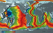
Present plate boundaries
Most present plate boundaries are easily identifiable from the pattern of recent seismicityEarthquake
An earthquake is the result of a sudden release of energy in the Earth's crust that creates seismic waves. The seismicity, seismism or seismic activity of an area refers to the frequency, type and size of earthquakes experienced over a period of time...
. This is now backed up by the use of GPS data, to confirm the presence of significant relative movement between plates.
Past plate boundaries
Identifying past (but now inactive) plate boundaries within current plates is generally based on evidence for an ocean that has now closed up. The line where the ocean used to be is normally marked by pieces of the crust from that ocean, included in the collision zone, known as ophiolitesOphiolites
An ophiolite is a section of the Earth's oceanic crust and the underlying upper mantle that has been uplifted and exposed above sea level and often emplaced onto continental crustal rocks...
. The line across which two plates became joined to form a single larger plate, is known as a suture
Suture (geology)
In structural geology, a suture is a major fault zone through an orogen or mountain range. Sutures separate terranes, tectonic units that have different plate tectonic, metamorphic and paleogeographic histories...
.
In many orogenic belts
Orogeny
Orogeny refers to forces and events leading to a severe structural deformation of the Earth's crust due to the engagement of tectonic plates. Response to such engagement results in the formation of long tracts of highly deformed rock called orogens or orogenic belts...
, the collision is not just between two plates, but involves the sequential accretion
Accretion (geology)
Accretion is a process by which material is added to a tectonic plate or a landmass. This material may be sediment, volcanic arcs, seamounts or other igneous features.-Description:...
of smaller terrane
Terrane
A terrane in geology is short-hand term for a tectonostratigraphic terrane, which is a fragment of crustal material formed on, or broken off from, one tectonic plate and accreted or "sutured" to crust lying on another plate...
s. Terranes are smaller pieces of continental crust that have been caught up in an orogeny, such as continental fragment
Continental fragment
Continental crustal fragments, partially synonymous with microcontinents, are fragments of continents thought to have been broken off from the main continental mass forming distinct islands, possibly several hundred kilometers from their place of origin...
s or island arc
Island arc
An island arc is a type of archipelago composed of a chain of volcanoes which alignment is arc-shaped, and which are situated parallel and close to a boundary between two converging tectonic plates....
s.
Reference frames
Plate motions, both those observable now and in the past, are referred ideally to a reference frameFrame of reference
A frame of reference in physics, may refer to a coordinate system or set of axes within which to measure the position, orientation, and other properties of objects in it, or it may refer to an observational reference frame tied to the state of motion of an observer.It may also refer to both an...
that allows other plate motions to be calculated. For example, a central plate, such as the African plate, may have the motions of adjacent plates referred to it. By composition of reconstructions, additional plates can be reconstructed to the central plate. In turn, the reference plate may be reconstructed, together with the other plates, to another reference frame, such as the earth's magnetic field, as determined from paleomagnetic measurements of rocks of known age. A global hotspot reference frame has been postulated (see, e.g., W. Jason Morgan
W. Jason Morgan
William Jason Morgan is an American geophysicist who has made seminal contributions to the theory of plate tectonics and geodynamics...
) but there is now evidence that not all hotspots are necessarily fixed in their locations relative to one another or the earth's spin axis. However, there are groups of such hotspots that appear to be fixed within the constraints of available data, within particular mesoplates
Mesoplates
The concept of "mesoplates" was introduced as a heuristic for characterizing the motion of lithospheric plates relative to the sublithospheric source region of hotspot volcanism . W. Jason Morgan , originally suggested that hotspots The concept of "mesoplates" was introduced as a heuristic for...
.
Euler poles
The movement of a rigid body, such as a plate, on the surface of a sphere can be described as rotation about a fixed axis (relative to the chosen reference frame). This pole of rotation is known as an Euler poleEuler's rotation theorem
In geometry, Euler's rotation theorem states that, in three-dimensional space, any displacement of a rigid body such that a point on the rigid body remains fixed, is equivalent to a single rotation about some axis that runs through the fixed point. It also means that the composition of two...
. The movement of a plate is completely specified in terms of its Euler pole and the angular rate of rotation about the pole. Euler poles defined for current plate motions can be used to reconstruct plates in the recent past (few million years). At earlier stages of earth's history, new Euler poles need to be defined.
Estimating past plate motions
Geometric matching of continental borders
Certain fits between continents, particularly that between South America and Africa, were known long before the development of a theory that could adequately explain them. The reconstruction before Atlantic rifting by Bullard based on a least-squares fitting at the 500 fathomFathom
A fathom is a unit of length in the imperial and the U.S. customary systems, used especially for measuring the depth of water.There are 2 yards in an imperial or U.S. fathom...
contour still provides the best match to paleomagnetic pole data for the two sides from the middle of Paleozoic
Paleozoic
The Paleozoic era is the earliest of three geologic eras of the Phanerozoic eon, spanning from roughly...
to Late Triassic
Late Triassic
The Late Triassic is in the geologic timescale the third and final of three epochs of the Triassic period. The corresponding series is known as the Upper Triassic. In the past it was sometimes called the Keuper, after a German lithostratigraphic group that has a roughly corresponding age...
.
Plate motion from magnetic stripes
Plate reconstructions in the recent geological past mainly use the pattern of magnetic stripesMagnetic anomaly
In geophysics, a magnetic anomaly is a local variation in the Earth's magnetic field resulting from variations in the chemistry or magnetism of the rocks. Mapping of variation over an area is valuable in detecting structures obscured by overlying material...
in oceanic crust
Oceanic crust
Oceanic crust is the part of Earth's lithosphere that surfaces in the ocean basins. Oceanic crust is primarily composed of mafic rocks, or sima, which is rich in iron and magnesium...
to remove the effects of seafloor spreading
Seafloor spreading
Seafloor spreading is a process that occurs at mid-ocean ridges, where new oceanic crust is formed through volcanic activity and then gradually moves away from the ridge. Seafloor spreading helps explain continental drift in the theory of plate tectonics....
. The individual stripes are dated from magnetostratigraphy
Magnetostratigraphy
Magnetostratigraphy is a geophysical correlation technique used to date sedimentary and volcanic sequences. The method works by collecting oriented samples at measured intervals throughout the section. The samples are analyzed to determine their characteristic remanent magnetization , that is, the...
so that their time of formation is known. Each stripe (and its mirror image) represents a plate boundary at a particular time in the past, allowing the two plates to be repositioned relative to one another. The oldest oceanic crust is of Jurassic
Jurassic
The Jurassic is a geologic period and system that extends from about Mya to Mya, that is, from the end of the Triassic to the beginning of the Cretaceous. The Jurassic constitutes the middle period of the Mesozoic era, also known as the age of reptiles. The start of the period is marked by...
age, providing a lower age limit of about 175 Ma for the use of such data. Reconstructions derived in this way are only relative.
Sampling
PaleomagneticPaleomagnetism
Paleomagnetism is the study of the record of the Earth's magnetic field in rocks. Certain minerals in rocks lock-in a record of the direction and intensity of the magnetic field when they form. This record provides information on the past behavior of Earth's magnetic field and the past location of...
pole data is obtained by taking oriented samples of rock. Good quality poles have been recovered from many different rock types. In igneous rock
Igneous rock
Igneous rock is one of the three main rock types, the others being sedimentary and metamorphic rock. Igneous rock is formed through the cooling and solidification of magma or lava...
s, the magnetic minerals have cooled through the curie point
Curie point
In physics and materials science, the Curie temperature , or Curie point, is the temperature at which a ferromagnetic or a ferrimagnetic material becomes paramagnetic on heating; the effect is reversible. A magnet will lose its magnetism if heated above the Curie temperature...
, typically providing good quality poles. Metamorphic rocks may contain new magnetic minerals but are not normally used to obtain poles due to their typically high magnetic anisotropy. Sedimentary rocks generally have a complex set of magnetic components such as derived clasts and mineral grains with their own inherited magnetization, primary magnetization acquired at the time of sedimentation and secondary magnetization related to subsequent diagenesis
Diagenesis
In geology and oceanography, diagenesis is any chemical, physical, or biological change undergone by a sediment after its initial deposition and during and after its lithification, exclusive of surface alteration and metamorphism. These changes happen at relatively low temperatures and pressures...
and authigenic
Authigenic
An authigenic mineral or sedimentary rock deposit is one that was generated where it is found or observed. Authigenic sedimentary minerals form during sedimentation by precipitation or recrystallization instead of being transported from elsewhere by water or wind. Authigenic sediments are the main...
mineral growth. Progressive demagnetization is used to discriminate between the components to identify the primary magnetization. The poles shown by the primary magnetization represent a record of their position relative to the magnetic pole at the time when the rock was formed. Suitable rocks of the right age are not present everywhere, so some pieces of the puzzle remain very unconstrained.
Good quality magnetic poles are added to the Global Paleomagnetic Database, which is accessible from the World Data Center A in the USA at Boulder, Colorado
Boulder, Colorado
Boulder is the county seat and most populous city of Boulder County and the 11th most populous city in the U.S. state of Colorado. Boulder is located at the base of the foothills of the Rocky Mountains at an elevation of...
; and from the Norwegian Geological Survey
Norwegian Geological Survey
Norwegian Geological Survey , abbr:NGU is a Norwegian government agency responsible for geologic mapping and research. The agency is located in Trondheim with an office in Tromsø, with about 225 employees...
in Trondheim
Trondheim
Trondheim , historically, Nidaros and Trondhjem, is a city and municipality in Sør-Trøndelag county, Norway. With a population of 173,486, it is the third most populous municipality and city in the country, although the fourth largest metropolitan area. It is the administrative centre of...
.
Apparent polar wander paths
Poles from different ages in a single area can be used to construct an apparent polar wanderApparent polar wander
Apparent polar wander is the imaginary movement of the Earth's magnetic poles relative to a continent while regarding the continent being studied as fixed in position, as determined by paleomagnetic data...
(APW) path. If paths from adjacent crustal fragments are identical, this is taken to indicate that there has been no relative movement between them during the period covered by the path. Divergence of APW paths indicates that the areas in question have acted independently in the past with the point of divergence marking the time at which they became joined.
Observed paleomagnetic poles show only the approximate latitude
Latitude
In geography, the latitude of a location on the Earth is the angular distance of that location south or north of the Equator. The latitude is an angle, and is usually measured in degrees . The equator has a latitude of 0°, the North pole has a latitude of 90° north , and the South pole has a...
at the time but provide no constraint on the longitude
Longitude
Longitude is a geographic coordinate that specifies the east-west position of a point on the Earth's surface. It is an angular measurement, usually expressed in degrees, minutes and seconds, and denoted by the Greek letter lambda ....
. For this reason older plate reconstructions have much larger uncertainties associated with them.
Hotspot tracks
Hotspot (geology)
The places known as hotspots or hot spots in geology are volcanic regions thought to be fed by underlying mantle that is anomalously hot compared with the mantle elsewhere. They may be on, near to, or far from tectonic plate boundaries. There are two hypotheses to explain them...
allows the plate on which they sit to be progressively restored so that a seamount is moved back over the hotspot at its time of formation. This method can be used back to the Early Cretaceous
Early Cretaceous
The Early Cretaceous or the Lower Cretaceous , is the earlier or lower of the two major divisions of the Cretaceous...
, the age of the oldest evidence for hotspot activity. This method gives an absolute reconstruction of both latitude and longitude, although before about 90 Ma there is evidence of relative motion between hotspot groups.
Slab constraints
Once oceanic plates subduct in the lower mantle (slabs), they are assumed to sink in a near-vertical manner. With the help of seismic wave tomography, this can be used to constrain plate reconstructions at first order back to the Permian.Other evidence for past plate configurations
Some plate reconstructions are supported by other geological evidence, such as the distribution of sedimentarySedimentary rock
Sedimentary rock are types of rock that are formed by the deposition of material at the Earth's surface and within bodies of water. Sedimentation is the collective name for processes that cause mineral and/or organic particles to settle and accumulate or minerals to precipitate from a solution....
rock types, the position of orogenic belts
Orogeny
Orogeny refers to forces and events leading to a severe structural deformation of the Earth's crust due to the engagement of tectonic plates. Response to such engagement results in the formation of long tracts of highly deformed rock called orogens or orogenic belts...
and faunal provinces shown by particular fossils. These are semi-quantitative methods of reconstruction.
Sedimentary rock types
Some types of sedimentary rock are restricted to certain latitudinal belts. Glacial deposits for instance are generally confined to high latitudes, whereas evaporiteEvaporite
Evaporite is a name for a water-soluble mineral sediment that result from concentration and crystallization by evaporation from an aqueous solution. There are two types of evaporate deposits, marine which can also be described as ocean deposits, and non-marine which are found in standing bodies of...
s are generally formed in the tropics.
Faunal provinces
Oceans between continents provide barriers to plant and animal migration. Areas that have become separated tend to develop their own fauna and flora. This is particularly the case for plants and land animals but is also true for shallow water marine species, such as trilobiteTrilobite
Trilobites are a well-known fossil group of extinct marine arthropods that form the class Trilobita. The first appearance of trilobites in the fossil record defines the base of the Atdabanian stage of the Early Cambrian period , and they flourished throughout the lower Paleozoic era before...
s and brachiopod
Brachiopod
Brachiopods are a phylum of marine animals that have hard "valves" on the upper and lower surfaces, unlike the left and right arrangement in bivalve molluscs. Brachiopod valves are hinged at the rear end, while the front can be opened for feeding or closed for protection...
s, although their plankton
Plankton
Plankton are any drifting organisms that inhabit the pelagic zone of oceans, seas, or bodies of fresh water. That is, plankton are defined by their ecological niche rather than phylogenetic or taxonomic classification...
ic larva
Larva
A larva is a distinct juvenile form many animals undergo before metamorphosis into adults. Animals with indirect development such as insects, amphibians, or cnidarians typically have a larval phase of their life cycle...
e mean that they were able to migrate over smaller deep water areas. As oceans narrow before a collision occurs, the faunas start to become mixed again, providing supporting evidence for the closure and its timing.