

Planned community
Encyclopedia
Community
The term community has two distinct meanings:*a group of interacting people, possibly living in close proximity, and often refers to a group that shares some common values, and is attributed with social cohesion within a shared geographical location, generally in social units larger than a household...
that was carefully planned from its inception and is typically constructed in a previously undeveloped area. This contrasts with settlements that evolve in a more ad hoc
Ad hoc
Ad hoc is a Latin phrase meaning "for this". It generally signifies a solution designed for a specific problem or task, non-generalizable, and not intended to be able to be adapted to other purposes. Compare A priori....
fashion. Land use conflicts are less frequent in planned communities since they are planned carefully. New town
New town
A new town is a specific type of a planned community, or planned city, that was carefully planned from its inception and is typically constructed in a previously undeveloped area. This contrasts with settlements that evolve in a more ad hoc fashion. Land use conflicts are uncommon in new...
s can apply to specific communities especially in the United Kingdom
United Kingdom
The United Kingdom of Great Britain and Northern IrelandIn the United Kingdom and Dependencies, other languages have been officially recognised as legitimate autochthonous languages under the European Charter for Regional or Minority Languages...
where they are created under the New Towns Act 1946
New Towns Act 1946
The New Towns Act 1946 was an Act of the Parliament of the United Kingdom which allowed the government to designate areas as new towns, and passing development control functions to a Development Corporation. Several new towns were created in the years following its passing...
.
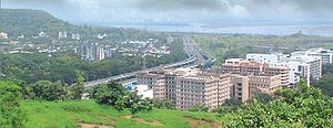
Navi Mumbai
Navi Mumbai
Navi Mumbai is a Planned Satellite City on the west coast of the Indian state of Maharashtra. It was developed in 1972 as a twin city of Mumbai, and is the largest planned city on the planet, with under the jurisdiction of the Navi Mumbai Municipal Corporation and a total area of . Navi Mumbai...
, a planned city near the Indian city of Mumbai
Mumbai
Mumbai , formerly known as Bombay in English, is the capital of the Indian state of Maharashtra. It is the most populous city in India, and the fourth most populous city in the world, with a total metropolitan area population of approximately 20.5 million...
, is the largest planned township in the world. It was also common in the European colonization of the Americas
European colonization of the Americas
The start of the European colonization of the Americas is typically dated to 1492. The first Europeans to reach the Americas were the Vikings during the 11th century, who established several colonies in Greenland and one short-lived settlement in present day Newfoundland...
to build according to a plan either on fresh ground or on the ruins of earlier Amerindian cities.
Planned capital cities
Several of the world's capital cities are planned cities, including Washington, D.C.Washington, D.C.
Washington, D.C., formally the District of Columbia and commonly referred to as Washington, "the District", or simply D.C., is the capital of the United States. On July 16, 1790, the United States Congress approved the creation of a permanent national capital as permitted by the U.S. Constitution....
, in the United States
United States
The United States of America is a federal constitutional republic comprising fifty states and a federal district...
, Canberra
Canberra
Canberra is the capital city of Australia. With a population of over 345,000, it is Australia's largest inland city and the eighth-largest city overall. The city is located at the northern end of the Australian Capital Territory , south-west of Sydney, and north-east of Melbourne...
in Australia
Australia
Australia , officially the Commonwealth of Australia, is a country in the Southern Hemisphere comprising the mainland of the Australian continent, the island of Tasmania, and numerous smaller islands in the Indian and Pacific Oceans. It is the world's sixth-largest country by total area...
, Brasília
Brasília
Brasília is the capital city of Brazil. The name is commonly spelled Brasilia in English. The city and its District are located in the Central-West region of the country, along a plateau known as Planalto Central. It has a population of about 2,557,000 as of the 2008 IBGE estimate, making it the...
in Brazil
Brazil
Brazil , officially the Federative Republic of Brazil , is the largest country in South America. It is the world's fifth largest country, both by geographical area and by population with over 192 million people...
, Belmopan
Belmopan
Belmopan , estimated population 20,000 is the capital city of Belize.Belmopan is located at , at an altitude of 76 metres above sea level. Belmopan was constructed just to the east of Belize River, inland from the former capital, the port of Belize City, after that city's near destruction by...
in Belize
Belize
Belize is a constitutional monarchy and the northernmost country in Central America. Belize has a diverse society, comprising many cultures and languages. Even though Kriol and Spanish are spoken among the population, Belize is the only country in Central America where English is the official...
, New Delhi
New Delhi
New Delhi is the capital city of India. It serves as the centre of the Government of India and the Government of the National Capital Territory of Delhi. New Delhi is situated within the metropolis of Delhi. It is one of the nine districts of Delhi Union Territory. The total area of the city is...
in India
India
India , officially the Republic of India , is a country in South Asia. It is the seventh-largest country by geographical area, the second-most populous country with over 1.2 billion people, and the most populous democracy in the world...
, Abuja
Abuja
Abuja is the capital city of Nigeria. It is located in the centre of Nigeria, within the Federal Capital Territory . Abuja is a planned city, and was built mainly in the 1980s. It officially became Nigeria's capital on 12 December 1991, replacing Lagos...
in Nigeria
Nigeria
Nigeria , officially the Federal Republic of Nigeria, is a federal constitutional republic comprising 36 states and its Federal Capital Territory, Abuja. The country is located in West Africa and shares land borders with the Republic of Benin in the west, Chad and Cameroon in the east, and Niger in...
, Astana
Astana
Astana , formerly known as Akmola , Tselinograd and Akmolinsk , is the capital and second largest city of Kazakhstan, with an officially estimated population of 708,794 as of 1 August 2010...
in Kazakhstan
Kazakhstan
Kazakhstan , officially the Republic of Kazakhstan, is a transcontinental country in Central Asia and Eastern Europe. Ranked as the ninth largest country in the world, it is also the world's largest landlocked country; its territory of is greater than Western Europe...
and Islamabad
Islamabad
Islamabad is the capital of Pakistan and the tenth largest city in the country. Located within the Islamabad Capital Territory , the population of the city has grown from 100,000 in 1951 to 1.7 million in 2011...
in Pakistan
Pakistan
Pakistan , officially the Islamic Republic of Pakistan is a sovereign state in South Asia. It has a coastline along the Arabian Sea and the Gulf of Oman in the south and is bordered by Afghanistan and Iran in the west, India in the east and China in the far northeast. In the north, Tajikistan...
.
Mainland China
Many ancient cities in China, especially those on the North China PlainNorth China Plain
The North China Plain is based on the deposits of the Yellow River and is the largest alluvial plain of eastern Asia. The plain is bordered on the north by the Yanshan Mountains and on the west by the Taihang Mountains edge of the Shanxi plateau. To the south, it merges into the Yangtze Plain...
, were carefully designed according to the fengshui
Feng shui
Feng shui ' is a Chinese system of geomancy believed to use the laws of both Heaven and Earth to help one improve life by receiving positive qi. The original designation for the discipline is Kan Yu ....
theory, featuring square or rectangular city walls, rectilinear road grid, and symmetrical layout. Famous examples are Chang'an
Chang'an
Chang'an is an ancient capital of more than ten dynasties in Chinese history, today known as Xi'an. Chang'an literally means "Perpetual Peace" in Classical Chinese. During the short-lived Xin Dynasty, the city was renamed "Constant Peace" ; yet after its fall in AD 23, the old name was restored...
in Tang dynasty
Tang Dynasty
The Tang Dynasty was an imperial dynasty of China preceded by the Sui Dynasty and followed by the Five Dynasties and Ten Kingdoms Period. It was founded by the Li family, who seized power during the decline and collapse of the Sui Empire...
and Beijing
Beijing
Beijing , also known as Peking , is the capital of the People's Republic of China and one of the most populous cities in the world, with a population of 19,612,368 as of 2010. The city is the country's political, cultural, and educational center, and home to the headquarters for most of China's...
.
In modern China, many special economic zones are developed from the sketch, for example, Pudong
Pudong
Pudong |Bank]]") is an area of Shanghai, China, located along the east side of the Huangpu River, across from the historic city center of Shanghai in Puxi. Formerly a little-developed agricultural area linked only by ferries, Pudong has grown rapidly since the 1990s and emerged as China's financial...
, a new district of Shanghai
Shanghai
Shanghai is the largest city by population in China and the largest city proper in the world. It is one of the four province-level municipalities in the People's Republic of China, with a total population of over 23 million as of 2010...
.
Ancient history
A sophisticated and technologically advanced urban culture is evident in the Indus Valley CivilizationIndus Valley Civilization
The Indus Valley Civilization was a Bronze Age civilization that was located in the northwestern region of the Indian subcontinent, consisting of what is now mainly modern-day Pakistan and northwest India...
which thrived in present-day Pakistan
Pakistan
Pakistan , officially the Islamic Republic of Pakistan is a sovereign state in South Asia. It has a coastline along the Arabian Sea and the Gulf of Oman in the south and is bordered by Afghanistan and Iran in the west, India in the east and China in the far northeast. In the north, Tajikistan...
and western parts of the modern day Republic of India from around 2600 BC. The quality of municipal city planning suggests knowledge of urban planning
Urban planning
Urban planning incorporates areas such as economics, design, ecology, sociology, geography, law, political science, and statistics to guide and ensure the orderly development of settlements and communities....
and efficient municipal governments which placed a high priority on hygiene
Hygiene
Hygiene refers to the set of practices perceived by a community to be associated with the preservation of health and healthy living. While in modern medical sciences there is a set of standards of hygiene recommended for different situations, what is considered hygienic or not can vary between...
. The streets of major cities in present day Pakistan such as Mohenjo-daro
Mohenjo-daro
Mohenjo-daro is an archeological site situated in what is now the province of Sindh, Pakistan. Built around 2600 BC, it was one of the largest settlements of the ancient Indus Valley Civilization, and one of the world's earliest major urban settlements, existing at the same time as the...
and Harappa
Harappa
Harappa is an archaeological site in Punjab, northeast Pakistan, about west of Sahiwal. The site takes its name from a modern village located near the former course of the Ravi River. The current village of Harappa is from the ancient site. Although modern Harappa has a train station left from...
, the world's earliest planned cities, were laid out in a perfect grid pattern
Grid plan
The grid plan, grid street plan or gridiron plan is a type of city plan in which streets run at right angles to each other, forming a grid...
comparable to that of present day New York City
New York City
New York is the most populous city in the United States and the center of the New York Metropolitan Area, one of the most populous metropolitan areas in the world. New York exerts a significant impact upon global commerce, finance, media, art, fashion, research, technology, education, and...
. The houses were protected from noise, odours, and thieves.
As seen in the ancient sites of Harappa
Harappa
Harappa is an archaeological site in Punjab, northeast Pakistan, about west of Sahiwal. The site takes its name from a modern village located near the former course of the Ravi River. The current village of Harappa is from the ancient site. Although modern Harappa has a train station left from...
and Mohenjo-daro
Mohenjo-daro
Mohenjo-daro is an archeological site situated in what is now the province of Sindh, Pakistan. Built around 2600 BC, it was one of the largest settlements of the ancient Indus Valley Civilization, and one of the world's earliest major urban settlements, existing at the same time as the...
in Pakistan, this urban plan included the world's first urban sanitation
Sanitation
Sanitation is the hygienic means of promoting health through prevention of human contact with the hazards of wastes. Hazards can be either physical, microbiological, biological or chemical agents of disease. Wastes that can cause health problems are human and animal feces, solid wastes, domestic...
systems. Within the city, individual homes or groups of homes obtained water from well
Water well
A water well is an excavation or structure created in the ground by digging, driving, boring or drilling to access groundwater in underground aquifers. The well water is drawn by an electric submersible pump, a trash pump, a vertical turbine pump, a handpump or a mechanical pump...
s. From a room that appears to have been set aside for bathing, waste water
Wastewater
Wastewater is any water that has been adversely affected in quality by anthropogenic influence. It comprises liquid waste discharged by domestic residences, commercial properties, industry, and/or agriculture and can encompass a wide range of potential contaminants and concentrations...
was directed to covered drains, which lined the major streets. Houses opened only to inner courtyard
Courtyard
A court or courtyard is an enclosed area, often a space enclosed by a building that is open to the sky. These areas in inns and public buildings were often the primary meeting places for some purposes, leading to the other meanings of court....
s and smaller lanes.
The ancient Indus systems of sewage
Sewage
Sewage is water-carried waste, in solution or suspension, that is intended to be removed from a community. Also known as wastewater, it is more than 99% water and is characterized by volume or rate of flow, physical condition, chemical constituents and the bacteriological organisms that it contains...
and drainage
Drainage
Drainage is the natural or artificial removal of surface and sub-surface water from an area. Many agricultural soils need drainage to improve production or to manage water supplies.-Early history:...
that were developed and used in cities throughout the Indus Valley were far more advanced than any found in contemporary urban sites in the Middle East
Middle East
The Middle East is a region that encompasses Western Asia and Northern Africa. It is often used as a synonym for Near East, in opposition to Far East...
and even more efficient than those in some areas of modern South Asia today. The advanced architecture of the Harappan
Harappan
Harappan can refer to:* Aspects related to Harappa an archaeological site and city in northeast Pakistan* The Indus Valley Civilization that thrived along Indus River...
s is shown by their impressive dockyards, granaries
Granary
A granary is a storehouse for threshed grain or animal feed. In ancient or primitive granaries, pottery is the most common use of storage in these buildings. Granaries are often built above the ground to keep the stored food away from mice and other animals.-Early origins:From ancient times grain...
, warehouse
Warehouse
A warehouse is a commercial building for storage of goods. Warehouses are used by manufacturers, importers, exporters, wholesalers, transport businesses, customs, etc. They are usually large plain buildings in industrial areas of cities and towns. They usually have loading docks to load and unload...
s, brick platforms, and protective walls.
Medieval history
A number of medieval Indian cities were planned including:- AhmedabadAhmedabadAhmedabad also known as Karnavati is the largest city in Gujarat, India. It is the former capital of Gujarat and is also the judicial capital of Gujarat as the Gujarat High Court has its seat in Ahmedabad...
in Gujarat. Established by Sultan Ahmad Shah in 1411. - UdaipurUdaipur, RajasthanUdaipur , also known as the City of Lakes, is a city, a Municipal Council and the administrative headquarters of the Udaipur district in the state of Rajasthan in western India. It is located southwest of the state capital, Jaipur, west of Kota, and northeast from Ahmedabad...
in RajasthanRajasthanRājasthān the land of Rajasthanis, , is the largest state of the Republic of India by area. It is located in the northwest of India. It encompasses most of the area of the large, inhospitable Great Indian Desert , which has an edge paralleling the Sutlej-Indus river valley along its border with...
. It was the historic capital of the former kingdom of MewarMewarMewar is a region of south-central Rajasthan state in western India. It includes the present-day districts of Pratapgarh, Bhilwara, Chittorgarh, Rajsamand, Udaipur, Dungarpur, Banswara and some of the part of Gujarat and Madhya Pradesh. The region was for centuries a Rajput kingdom that later...
. - MaduraiMaduraiMadurai is the third largest city in the Indian state of Tamil Nadu and one of the oldest continuously inhabited cities in the world. It served as the capital city of the Pandyan Kingdom. It is the administrative headquarters of Madurai District and is famous for its temples built by Pandyan and...
, in the state of Tamilnadu. It was the capital of the erstwhile Pandyan kingdomPandyan KingdomThe Pandyan dynasty was an ancient Tamil dynasty. The Pandyas were one of the four Tamil dynasties , which ruled South India until the 15th century CE. They initially ruled their country Pandya Nadu from Korkai, a seaport on the Southernmost tip of the Indian Peninsula, and in later times moved...
and is noted for its lotus-like symmetry. - Fatehpur SikriFatehpur SikriFatehpur Sikri is a city and a municipal board in Agra district in the state of Uttar Pradesh, India. Built near the much older Sikri, the historical city of Fatehabad, as it was first named, was constructed by Mughal emperor Akbar beginning in 1570...
in AgraAgraAgra a.k.a. Akbarabad is a city on the banks of the river Yamuna in the northern state of Uttar Pradesh, India, west of state capital, Lucknow and south from national capital New Delhi. With a population of 1,686,976 , it is one of the most populous cities in Uttar Pradesh and the 19th most...
. Its planning was done by the Mughal emperorMughal EmpireThe Mughal Empire , or Mogul Empire in traditional English usage, was an imperial power from the Indian Subcontinent. The Mughal emperors were descendants of the Timurids...
Akbar the GreatAkbar the GreatAkbar , also known as Shahanshah Akbar-e-Azam or Akbar the Great , was the third Mughal Emperor. He was of Timurid descent; the son of Emperor Humayun, and the grandson of the Mughal Emperor Zaheeruddin Muhammad Babur, the ruler who founded the Mughal dynasty in India...
. - VijayanagarVijayanagaraVijayanagara is in Bellary District, northern Karnataka. It is the name of the now-ruined capital city "which was regarded as the second Rome" that surrounds modern-day Hampi, of the historic Vijayanagara empire which extended over the southern part of India....
in Karnataka, the capital of the erstwhile Vijayanagara EmpireVijayanagara EmpireThe Vijayanagara Empire , referred as the Kingdom of Bisnaga by the Portuguese, was an empire based in South Indian in the Deccan Plateau region. It was established in 1336 by Harihara I and his brother Bukka Raya I of the Yadava lineage. The empire rose to prominence as a culmination of attempts...
. - HampiHampiHampi is a village in northern Karnataka state, India. It is located within the ruins of Vijayanagara, the former capital of the Vijayanagara Empire. Predating the city of Vijayanagara, it continues to be an important religious centre, housing the Virupaksha Temple, as well as several other...
in KarnatakaKarnatakaKarnataka , the land of the Kannadigas, is a state in South West India. It was created on 1 November 1956, with the passing of the States Reorganisation Act and this day is annually celebrated as Karnataka Rajyotsava...
, which was the former capital of the Vijayanagara EmpireVijayanagara EmpireThe Vijayanagara Empire , referred as the Kingdom of Bisnaga by the Portuguese, was an empire based in South Indian in the Deccan Plateau region. It was established in 1336 by Harihara I and his brother Bukka Raya I of the Yadava lineage. The empire rose to prominence as a culmination of attempts...
prior to the city of Vijayanagar.
Modern history
The period following independencePartition of India
The Partition of India was the partition of British India on the basis of religious demographics that led to the creation of the sovereign states of the Dominion of Pakistan and the Union of India on 14 and 15...
saw India
India
India , officially the Republic of India , is a country in South Asia. It is the seventh-largest country by geographical area, the second-most populous country with over 1.2 billion people, and the most populous democracy in the world...
being defined into smaller geographical regions. New states such as Gujarat were formed with planned capital cities.
The major planned cities of India include:
- Navi MumbaiNavi MumbaiNavi Mumbai is a Planned Satellite City on the west coast of the Indian state of Maharashtra. It was developed in 1972 as a twin city of Mumbai, and is the largest planned city on the planet, with under the jurisdiction of the Navi Mumbai Municipal Corporation and a total area of . Navi Mumbai...
(New Mumbai), World Largest Planned city and Super city. - New DelhiNew DelhiNew Delhi is the capital city of India. It serves as the centre of the Government of India and the Government of the National Capital Territory of Delhi. New Delhi is situated within the metropolis of Delhi. It is one of the nine districts of Delhi Union Territory. The total area of the city is...
- NOIDA
- ChandigarhChandigarhChandigarh is a union territory of India that serves as the capital of two states, Haryana and Punjab. The name Chandigarh translates as "The Fort of Chandi". The name is from an ancient temple called Chandi Mandir, devoted to the Hindu goddess Chandi, in the city...
India's first planned city - Durgapur India's second planned city
- Gandhinagar
- PanchkulaPanchkulaPanchkula is a planned city in Panchkula district, Haryana, India. It is a satellite city of the Union Territory of Chandigarh. It also shares seamless border with Mohali district in Punjab. The prestigious Chandimandir Cantonment Headquarters of the Indian Army Western Command, is also located in...
- MohaliMohaliMohali is a city adjacent to Chandigarh, 18th District in Punjab, India. It is officially named after the eldest son of Guru Gobind Singh, Sahibzada Ajit Singh . It, along with Chandigarh and Panchkula, form a part of the Chandigarh Tricity...
- Greater NoidaGreater NoidaGreater Noida is located in the Gautam Budh Nagar district of the north Indian state of Uttar Pradesh . It is under the purview of the National Capital Region of India...
- UdaipurUdaipurUdaipur , also known as the City of Lakes, is a city, a Municipal Council and the administrative headquarters of the Udaipur district in the state of Rajasthan in western India. It is located southwest of the state capital, Jaipur, west of Kota, and northeast from Ahmedabad...
- AurovilleAurovilleAuroville is an "experimental" township in Viluppuram district in the state of Tamil Nadu, India, near Pondicherry in South India. It was founded in 1968 by Mirra Alfassa and designed by architect Roger Anger...
- Bhubaneshwar, the capital of OrissaOrissaOrissa , officially Odisha since Nov 2011, is a state of India, located on the east coast of India, by the Bay of Bengal. It is the modern name of the ancient nation of Kalinga, which was invaded by the Maurya Emperor Ashoka in 261 BC. The modern state of Orissa was established on 1 April...
- Dispur
- DhuleDhuleDhule is a city and a Municipal Corporation in Dhule district in northwestern part of Maharashtra state, India. It is one of the very few well-planned cities of India before Indian Independence.-Geography:Dhule is located at...
, MaharashtraMaharashtraMaharashtra is a state located in India. It is the second most populous after Uttar Pradesh and third largest state by area in India...
, a city planned by the renowned architect of India, Sir Vishveshwarayya. - Naya RaipurNaya RaipurNew Raipur is the upcoming Capital of Chhattisgarh being built 17 km far in the south-east direction from the existing capital Raipur...
, the upcoming capital of ChhattisgarhChhattisgarhChhattisgarh is a state in Central India, formed when the 16 Chhattisgarhi-speaking South-Eastern districts of Madhya Pradesh gained separate statehood on 1 November 2000.... - Bidhannagar(Salt Lake City), planned township near KolkataKolkataKolkata , formerly known as Calcutta, is the capital of the Indian state of West Bengal. Located on the east bank of the Hooghly River, it was the commercial capital of East India...
- KalyaniKalyaniKalyani may refer to:* Kalyani , a rāga in the Carnatic music of South India as well as Hindustani music* Kalyani , a type of ancient Hindu bathing well or pond* Kalyani, West Bengal, a town in the Nadia District of West Bengal...
- RajarhatRajarhatRajarhat Gopalpur , a neighbourhood of Calcutta, located in North 24 Parganas district of West Bengal, is a fast-growing planned new city. It is situated near the Netaji Subhash Chandra Bose International Airport. Many high-profile industrialists of national and international standing are...
(New Town), planned township near KolkataKolkataKolkata , formerly known as Calcutta, is the capital of the Indian state of West Bengal. Located on the east bank of the Hooghly River, it was the commercial capital of East India... - Jamshedpur, planned township in JharkhandJharkhandJharkhand is a state in eastern India. It was carved out of the southern part of Bihar on 15 November 2000. Jharkhand shares its border with the states of Bihar to the north, Uttar Pradesh and Chhattisgarh to the west, Orissa to the south, and West Bengal to the east...
- BhilaiBhilaiBhilai or Bhilai Nagar is a city in the Durg district of Chhattisgarh, in eastern central India. As of 2001, it had a population of 753,837. The city is located west of the capital Raipur, on the main Howrah–Mumbai rail line, and National Highway 6...
, planned township in Chattisgarh
In Pakistan
Pakistan
Pakistan , officially the Islamic Republic of Pakistan is a sovereign state in South Asia. It has a coastline along the Arabian Sea and the Gulf of Oman in the south and is bordered by Afghanistan and Iran in the west, India in the east and China in the far northeast. In the north, Tajikistan...
, the most notable planned city is the capital Islamabad
Islamabad
Islamabad is the capital of Pakistan and the tenth largest city in the country. Located within the Islamabad Capital Territory , the population of the city has grown from 100,000 in 1951 to 1.7 million in 2011...
, whose first foundations were laid during the 1950s. Sargodha
Sargodha
Sargodha is a city in the Sargodha District of Punjab province, Pakistan.Sargodha is located in the northwest of Pakistan. It is the eleventh largest city of Pakistan and also known as Pakistan's best citrus-producing area. It is an agricultural trade centre with various industries...
, Faisalabad
Faisalabad
Faisalabad , formerly known as Lyallpur, is the third largest metropolis in Pakistan, the second largest in the province of Punjab after Lahore, and a major industrial center in the heart of Pakistan. Before the foundation of the city in 1880, the area was very thinly populated. The population has...
, Gwadar
Gwadar
Gwadar also known as Godar is a developing port city on the southwestern Arabian Sea coast of Pakistan. It is the district headquarters of Gwadar District in Balochistan province and has a population of approximately 50,000.Gwadar is strategically located at the apex of the Arabian Sea and at the...
Chenab Nagar and D.G.Khan are also planned cities.
Iran
In the period of the Persian Safavid Empire, IsfahanIsfahan (city)
Isfahan , historically also rendered in English as Ispahan, Sepahan or Hispahan, is the capital of Isfahan Province in Iran, located about 340 km south of Tehran. It has a population of 1,583,609, Iran's third largest city after Tehran and Mashhad...
, the Persian capital, was built according to a planned scheme, consisting of a long boulevard and planned housing and green areas around it.
In modern day Iran more than 20 planned cities have been developed or are under construction, mostly around Iran's main metropolitan areas such as Tehran
Tehran
Tehran , sometimes spelled Teheran, is the capital of Iran and Tehran Province. With an estimated population of 8,429,807; it is also Iran's largest urban area and city, one of the largest cities in Western Asia, and is the world's 19th largest city.In the 20th century, Tehran was subject to...
, Isfahan
Isfahan (city)
Isfahan , historically also rendered in English as Ispahan, Sepahan or Hispahan, is the capital of Isfahan Province in Iran, located about 340 km south of Tehran. It has a population of 1,583,609, Iran's third largest city after Tehran and Mashhad...
, Shiraz
Shiraz, Iran
Shiraz is the sixth most populous city in Iran and is the capital of Fars Province, the city's 2009 population was 1,455,073. Shiraz is located in the southwest of Iran on the Roodkhaneye Khoshk seasonal river...
and Tabriz
Tabriz
Tabriz is the fourth largest city and one of the historical capitals of Iran and the capital of East Azerbaijan Province. Situated at an altitude of 1,350 meters at the junction of the Quri River and Aji River, it was the second largest city in Iran until the late 1960s, one of its former...
. Some of these new cities are built for special purposes such as:
- PardisPardisPardis , meaning "New City of Pardis") is a city in the Central District of Tehran County, Tehran Province, Iran. At the 2006 census, its population was 25,360, in 7,228 families.Pardis is a new planned city that has absorbed over 9,775 inhabitants in 2001...
, which is built as a scientific city. - Poulad-ShahrPoulad-shahrPoulad-Shahr is one of the planned cities of Iran in the Isfahan province. Poulad-Shahr is an industrious city built for the housing of the workers at Isfahan's steel industry.The name Poulad-Shahr means the "Steel-city" in Persian....
, which is an industrial city built for the housing of Isfahan's steel industry workers. - Shirin ShahrShirin ShahrShirin Shahr is a new planned city in the Khuzestan province of Iran. It is intended to house the personnel of the sugar industry in the area. The name Shirin Shahr means "Sweet City" in Persian....
which is to provide housing for the sugar industry personnel. - TehranparsTehranparsTehranpars or Tehran Pars is a planned city inside the Greater Tehran Area. It is considered a neighbourhood of Tehran City and lies in Tehran's eastern flank inside the area of the 4th and 8th municipalities of Tehran....
which was built to house Tehran's additional population. - Shahrak-e GharbShahrak-e GharbShahrak-e Gharb is a planned town built as a massive project of modern apartment buildings and villas in the north-western part of Tehran, Iran. Originally built based on the model of upscale American suburbs, today it is considered one of Tehran's neighborhoods...
, built as a massive project of modern apartment buildings. - ParandParandThe new town of Parand is situated 10 km west from Robat Karim on the way to Saveh and it has about 7000 students in islamic azad university...
which is intended to provide residences for the staff of Imam Khomeini International AirportImam Khomeini International AirportImam Khomeini International Airport is located in Ahmadabad, Iran. The airport is located about southwest of the city near the localities of Robat-Karim and Eslamshahr. It was designed to replace Mehrabad International Airport, which is in the west of the city, now inside the city boundaries...
. - Shushtar New TownShushtar-External links:** Hamid-Reza Hosseini, Shush at the foot of Louvre , in Persian, Jadid Online, 10 March 2009, .Audio slideshow: .* .* * , PressTV, 13 June 2010....
which was built to provide housing for the employees of a sugar cane processing plant.
576,000 people were been planned to be settled in Iran's new towns by the year 2005.
For a list of Iran's modern planned cities see: List of Iran's planned cities.
Israel
Development town
Development town is a term used to refer to the new settlements that were built in Israel during the 1950s in order to provide permanent housing to a large influx of Jewish refugees from Arab countries, Holocaust survivors from Europe and new immigrants , who arrived to the newly established State...
s. The most successful is Ashdod with more than 200,000 inhabitants, a port and developed infrastructure. Other cities that were developed following lineation plan are Karmiel
Karmiel
Karmiel is a city in northern Israel. Established in 1964 as a development town, Karmiel is located in the Beit HaKerem Valley which divides upper and lower Galilee. The city is located south of the Acre-Safed road, from Safed and from Acre...
and Arad. Modi'in has been another of the country's most successful planned cities, construction began in 1994, it now has a population of over 67,000. Modi'in also rates higher in terms of average salary and graduation rates than the national average, Israeli architect Moshe Safdie
Moshe Safdie
Moshe Safdie, CC, FAIA is an architect, urban designer, educator, theorist, and author. Born in the city of Haifa, then Palestine and now Israel, he moved with his family to Montreal, Canada, when he was 15 years old.-Career:...
designed and planned the city. Many Israeli settlement
Israeli settlement
An Israeli settlement is a Jewish civilian community built on land that was captured by Israel from Jordan, Egypt, and Syria during the 1967 Six-Day War and is considered occupied territory by the international community. Such settlements currently exist in the West Bank...
s characteristically follow this model, including towns like Modi'in Illit
Modi'in Illit
Modi'in Illit is a Haredi Israeli settlement and a city in the West Bank, situated midway between Jerusalem and Tel Aviv. Modi'in Illit was granted city status by the Israeli government in 2008. It is located six kilometres northeast of Modi'in-Maccabim-Re'ut and is often referred to as Kiryat...
and Betar Illit
Betar Illit
Beitar Illit is an Israeli settlement and city west of Gush Etzion, south of Jerusalem, in the Judean Mountains of the West Bank. At the end of 2007, it had a total population of 38,800 consisting of over 6000 families. By 2020, the population is expected to reach 100,000...
.
Japan
Kyoto
is a city in the central part of the island of Honshū, Japan. It has a population close to 1.5 million. Formerly the imperial capital of Japan, it is now the capital of Kyoto Prefecture, as well as a major part of the Osaka-Kobe-Kyoto metropolitan area.-History:...
was developed as a planned city in 794 as a new imperial capital (then called Heian-kyō
Heian-kyo
Heian-kyō , was one of several former names for the city now known as Kyoto. It was the capital of Japan for over one thousand years, from 794 to 1868 with an interruption in 1180....
), built on a grid layout modeled after the Tang dynasty
Tang Dynasty
The Tang Dynasty was an imperial dynasty of China preceded by the Sui Dynasty and followed by the Five Dynasties and Ten Kingdoms Period. It was founded by the Li family, who seized power during the decline and collapse of the Sui Empire...
capital of Chang'an
Chang'an
Chang'an is an ancient capital of more than ten dynasties in Chinese history, today known as Xi'an. Chang'an literally means "Perpetual Peace" in Classical Chinese. During the short-lived Xin Dynasty, the city was renamed "Constant Peace" ; yet after its fall in AD 23, the old name was restored...
(modern day Xi'an
Xi'an
Xi'an is the capital of the Shaanxi province, and a sub-provincial city in the People's Republic of China. One of the oldest cities in China, with more than 3,100 years of history, the city was known as Chang'an before the Ming Dynasty...
), and remained the capital for over a millennium. The grid layout remains, reflected in major east-west streets being numbered, such as . In modern times, Sapporo was built from 1868, following an American grid plan
Grid plan
The grid plan, grid street plan or gridiron plan is a type of city plan in which streets run at right angles to each other, forming a grid...
, and is today the fifth-largest city in Japan. Both these cities have regular addressing systems (following the grid) unlike the usual subdivision-based Japanese addressing system
Japanese addressing system
The Japanese addressing system is used to identify a specific location in Japan. In Japanese, addresses are written using the opposite convention from Western addresses, starting with the biggest geographical entities down to the more specific ones....
.
Malaysia
- See entries for Shah AlamShah AlamShah Alam is the state capital of Selangor, Malaysia situated within the Petaling District and a small portion of the neighboring Klang District. It is located about west of the country's capital, Kuala Lumpur. Shah Alam replaced Kuala Lumpur as the capital city of the state of Selangor in 1978...
, PutrajayaPutrajayaPutrajaya is a planned city, located 25km south of Kuala Lumpur, that serves as the federal administrative centre of Malaysia. The seat of government was shifted in 1999 from Kuala Lumpur to Putrajaya, due to the overcrowding and congestion in the Kuala Lumpur areas...
, CyberjayaCyberjayaCyberjaya is a town with a science park as the core that forms a key part of the Multimedia Super Corridor in Malaysia. It is located in the district of Sepang, Selangor and is situated about 50 km south of Kuala Lumpur, the capital of Malaysia...
, Petaling Jaya(New Town)Petaling JayaPetaling Jaya is a Malaysian city originally developed as a satellite township for Kuala Lumpur comprising mostly residential and some industrial areas. It is located in the Petaling district of Selangor with an area of approximately 97.2 km². On 20 June 2006, Petaling Jaya was granted a...
and the Multimedia Super Corridor. - Kulim Hi-Tech Park
- See entries for Nusajaya and Iskandar MalaysiaIskandar MalaysiaIskandar Malaysia ', formerly known as Iskandar Development Region and South Johor Economic Region is the main southern development corridor in Johor, Malaysia. The Iskandar Malaysia was established on 30 July 2006...
Palestine
In the West BankWest Bank
The West Bank ) of the Jordan River is the landlocked geographical eastern part of the Palestinian territories located in Western Asia. To the west, north, and south, the West Bank shares borders with the state of Israel. To the east, across the Jordan River, lies the Hashemite Kingdom of Jordan...
, the city of Rawabi
Rawabi
Rawabi is the first Palestinian planned city in the West Bank. Rawabi is to be located near Ramallah and Bir Zeit. A master plan has been drawn up for the city, which will consist of 10,000 homes in six neighborhoods with a population of 40,000. Homebuyers will have access to an affordable...
has been under construction since January 2010.
Philippines
Quezon CityQuezon City
Quezon City is the former capital and the most populous city in the Philippines. Located on the island of Luzon, Quezon City is one of the cities and municipalities that make up Metro Manila, the National Capital Region. The city was named after Manuel L...
was the planned city of President Manuel L. Quezon
Manuel L. Quezon
Manuel Luis Quezón y Molina served as president of the Commonwealth of the Philippines from 1935 to 1944. He was the first Filipino to head a government of the Philippines...
. He proposed a new city to be built northeast of Manila
Manila
Manila is the capital of the Philippines. It is one of the sixteen cities forming Metro Manila.Manila is located on the eastern shores of Manila Bay and is bordered by Navotas and Caloocan to the north, Quezon City to the northeast, San Juan and Mandaluyong to the east, Makati on the southeast,...
. Carefully planned districts include the Santa Mesa Heights (part of the original Burnham
Daniel Burnham
Daniel Hudson Burnham, FAIA was an American architect and urban planner. He was the Director of Works for the World's Columbian Exposition in Chicago. He took a leading role in the creation of master plans for the development of a number of cities, including Chicago and downtown Washington DC...
plan), Diliman Estate (includes the University of the Philippines
University of the Philippines
The ' is the national university of the Philippines. Founded in 1908 through Act No...
), New Manila, Cubao Commercial District, South Triangle, Housing Projects 1 (Roxas district), 2 & 3 (Quirino District), 4, 5 (Kamias-Kamuning District), 6, 7, and 8. President Elpidio Quirino
Elpidio Quirino
Elpidio Rivera Quirino was a Filipino politician, and the sixth President of the Philippines.A lawyer by profession, Quirino entered politics when he became a representative of Ilocos Sur from 1919 to 1925. He was then elected as senator from 1925–1931...
proclaimed Quezon City as capital of the Philippines on July 17, 1948. President Ferdinand Marcos
Ferdinand Marcos
Ferdinand Emmanuel Edralin Marcos, Sr. was a Filipino leader and an authoritarian President of the Philippines from 1965 to 1986. He was a lawyer, member of the Philippine House of Representatives and a member of the Philippine Senate...
restored Manila as capital on June 24, 1976. He then created a metropolitan area called Metro Manila
Metro Manila
Metropolitan Manila , the National Capital Region , or simply Metro Manila, is the metropolitan region encompassing the City of Manila and its surrounding areas in the Philippines...
. Due to the failed plan execution, Metro Manila remains congested.
Saudi Arabia
King Abdullah Economic CityKing Abdullah Economic City
King Abdullah Economic City is a megaproject announced in 2005 by Abdullah bin Abdulaziz Al Saud, the king of Saudi Arabia.-Overview:...
, a future planned city along the Red Sea
Red Sea
The Red Sea is a seawater inlet of the Indian Ocean, lying between Africa and Asia. The connection to the ocean is in the south through the Bab el Mandeb strait and the Gulf of Aden. In the north, there is the Sinai Peninsula, the Gulf of Aqaba, and the Gulf of Suez...
located in Saudi Arabia
Saudi Arabia
The Kingdom of Saudi Arabia , commonly known in British English as Saudi Arabia and in Arabic as as-Sa‘ūdiyyah , is the largest state in Western Asia by land area, constituting the bulk of the Arabian Peninsula, and the second-largest in the Arab World...
.
In 1975, Jubail Industrial City, also known as Jubail
Jubail
Jubail , is a city in the Eastern province on the Persian Gulf coast of Saudi Arabia. It consists of the Old Town of Al Jubail, which was originally a small fishing village, up to 1975 and the new industrial area....
, was designated as a new industrial city by the Saudi government
Politics of Saudi Arabia
The politics of Saudi Arabia takes place in the context of an Islamic absolute monarchy. The King of Saudi Arabia is both head of state and the head of government, but decisions are, to a large extent, made on the basis of consultation among the senior princes of the royal family and the religious...
. It provides 50% of the country's drinking water through desalination
Desalination
Desalination, desalinization, or desalinisation refers to any of several processes that remove some amount of salt and other minerals from saline water...
of the water from the Persian Gulf
Persian Gulf
The Persian Gulf, in Southwest Asia, is an extension of the Indian Ocean located between Iran and the Arabian Peninsula.The Persian Gulf was the focus of the 1980–1988 Iran-Iraq War, in which each side attacked the other's oil tankers...
.
South Korea
New Songdo CityNew Songdo City
Songdo International Business District is a planned international CBD currently under construction on 1,500 acres of reclaimed land along Incheon's waterfront, 40 miles west of Seoul, South Korea and connected to Incheon International Airport by a 7.4 mile highway bridge, called Incheon Bridge...
is a planned international business centre to be developed on 6 square kilometres of reclaimed land along Incheon's waterfront, 65 kilometres west of Seoul and connected to Incheon International Airport by a 10 kilometre highway bridge. This 10-year development project is estimated to cost in excess of $40 billion, making it the largest private development project ever undertaken anywhere in the world.
Since the 1990s, several planned communities were built in the Seoul Metropolitan Area to alleviate housing demands in Seoul
Seoul
Seoul , officially the Seoul Special City, is the capital and largest metropolis of South Korea. A megacity with a population of over 10 million, it is the largest city proper in the OECD developed world...
. They include:
- Several ongoing developments in HwaseongHwaseongHwaseong or Hwasong can refer to:*Hwaseong City, a city in Gyeonggi Province, South Korea*Hwasŏng , a county in North Hamgyong province, North Korea...
,including Bongdam, Dongtan, and Hyangnam - BundangBundangBundang is the southernmost district of Seongnam, Gyeonggi-do, South Korea. In addition to being the most populous part of the city, it also has the status of being one of the wealthiest regions in Gyeonggi Province...
, Seongnam City - IlsanIlsanIlsan is the name of two districts or wards in Goyang, Gyeonggi-do, South Korea...
, Goyang City - PangyoPangyoPangyo refers to a planned city surrounding Pangyo-dong, Baekhyeon-dong, Unjung-dong, and Sampyeong-dong of Bundang-gu and Siheung-dong and Sasong-dong of Sujeong-gu ....
, Seongnam City
United Arab Emirates
- Masdar CityMasdar CityMasdar is a project in Abu Dhabi, in the United Arab Emirates. Its core is a planned city, which is being built by the Abu Dhabi Future Energy Company, a subsidiary of Mubadala Development Company, with the majority of seed capital provided by the government of Abu Dhabi...
, conceived of as a mixed purpose residential and commercial area
Bosnia and Herzegovina
SlobomirSlobomir
Slobomir is a new town in Bosnia and Herzegovina. It is located on the Drina River near Bijeljina. It is part of the Bijeljina municipality. It was founded by Slobodan Pavlović, a Bosnian Serb philanthropist. It aims to be one of the major cities of post-war Bosnia-Herzegovina...
is a new town in Bosnia and Herzegovina
Bosnia and Herzegovina
Bosnia and Herzegovina , sometimes called Bosnia-Herzegovina or simply Bosnia, is a country in Southern Europe, on the Balkan Peninsula. Bordered by Croatia to the north, west and south, Serbia to the east, and Montenegro to the southeast, Bosnia and Herzegovina is almost landlocked, except for the...
and its name means: "the city of freedom and peace". It is located on the Drina
Drina
The Drina is a 346 kilometer long river, which forms most of the border between Bosnia and Herzegovina and Serbia. It is the longest tributary of the Sava River and the longest karst river in the Dinaric Alps which belongs to the Danube river watershed...
river near Bijeljina
Bijeljina
Bijeljina is a city and municipality in northeastern Bosnia and Herzegovina. The city is the second largest in the Republika Srpska entity after Banja Luka and fifth largest city in Bosnia and Herzegovina, and is situated on the flat rich plains of Semberija...
. It was founded by Slobodan Pavlović, a Bosnian philanthropist
Philanthropist
A philanthropist is someone who engages in philanthropy; that is, someone who donates his or her time, money, and/or reputation to charitable causes...
. It aims to be one of the major cities of post-war Bosnia and Herzegovina
Bosnia and Herzegovina
Bosnia and Herzegovina , sometimes called Bosnia-Herzegovina or simply Bosnia, is a country in Southern Europe, on the Balkan Peninsula. Bordered by Croatia to the north, west and south, Serbia to the east, and Montenegro to the southeast, Bosnia and Herzegovina is almost landlocked, except for the...
. In fact, the city will be located in two countries, Bosnia and Herzegovina and Serbia
Serbia
Serbia , officially the Republic of Serbia , is a landlocked country located at the crossroads of Central and Southeast Europe, covering the southern part of the Carpathian basin and the central part of the Balkans...
, although majority of it will be in Bosnia and Herzegovina. The city is named after its founder, Slobodan Pavlović, and his wife, Mira.
Bulgaria
The cities of Stara ZagoraStara Zagora
Stara Zagora is the sixth largest city in Bulgaria, and a nationally important economic center. Located in Southern Bulgaria, it is the administrative capital of the homonymous Stara Zagora Province...
and Kazanlak
Kazanlak
Kazanlak, formerly Kazanlık is a Bulgarian town in Stara Zagora Province, located in the middle of the plain of the same name, at the foot of the Balkan mountain range, at the eastern end of the Rose Valley...
, in central Bulgaria, were rebuilt as planned cities after they were burnt to the ground in the 1877-1878 Russia-Turkey War. Also the city of Dimitrovgrad
Dimitrovgrad, Bulgaria
Dimitrovgrad is a town in Haskovo Province, South-central Bulgaria, located close to the province capital - Haskovo. It is a newly founded settlement, built in the end of the 1940s. and named after the communist leader Georgi Dimitrov. The town is the administrative centre of the homonymous...
in south Bulgaria, that was planned as a key industrial and infrastructure center.
Denmark
FredericiaFredericia
Fredericia is a town located in Fredericia municipality in the eastern part of the Jutland peninsula in Denmark, in a sub-region known locally as Trekanten, or The Triangle...
was designed as a combination of town and military fortress following the devastation caused by the Thirty Years' War
Thirty Years' War
The Thirty Years' War was fought primarily in what is now Germany, and at various points involved most countries in Europe. It was one of the most destructive conflicts in European history....
. A more recently example is Ørestad
Ørestad
Ørestad is a developing city area in Copenhagen, Denmark, on the island of Amager. It is expected that 20,000 people will live in Ørestad, 20,000 will study, and 80,000 people will be employed in the area...
planned and built to strengthen development in the Copenhagen
Copenhagen
Copenhagen is the capital and largest city of Denmark, with an urban population of 1,199,224 and a metropolitan population of 1,930,260 . With the completion of the transnational Øresund Bridge in 2000, Copenhagen has become the centre of the increasingly integrating Øresund Region...
/Malmö
Malmö
Malmö , in the southernmost province of Scania, is the third most populous city in Sweden, after Stockholm and Gothenburg.Malmö is the seat of Malmö Municipality and the capital of Skåne County...
region.
Finland
The city of HelsinkiHelsinki
Helsinki is the capital and largest city in Finland. It is in the region of Uusimaa, located in southern Finland, on the shore of the Gulf of Finland, an arm of the Baltic Sea. The population of the city of Helsinki is , making it by far the most populous municipality in Finland. Helsinki is...
, previously just a small village, was rebuilt on a rocky peninsula near the sea in 1812 by decree of Alexander I, Grand-duke of Finland. The new town was to become the capital for the new Grand Duchy of Finland. The planner of the new town was Carl Ludvig Engel
Carl Ludvig Engel
Carl Ludvig Engel, or Johann Carl Ludwig Engel , was a German architect known for his neoclassical style. He had a great impact on the architecture of Finland in the first part of the 19th century....
.
However, the last city in Finland that was ordered to be built on a previously completely uninhabited land was Raahe
Raahe
Raahe is a town and municipality of Finland. Founded by Swedish statesman and Governor General of Finland Count Per Brahe the younger in 1649, it is one of 10 historic wooden towns remaining in Finland. Examples of other Finnish historic wooden towns are Kaskinen , Old Rauma, Porvoo , Jakobstad ,...
, founded by governor general Per Brahe the Younger in 1649.
Finland also has various "ekokyläs" or "ecological villages". For example, Tapiola
Tapiola
Tapiola or Hagalund is a district of Espoo on the south coast of Finland, and is one of the major urban centres of Espoo...
is a post-war garden city
Garden city movement
The garden city movement is a method of urban planning that was initiated in 1898 by Sir Ebenezer Howard in the United Kingdom. Garden cities were intended to be planned, self-contained communities surrounded by "greenbelts" , containing proportionate areas of residences, industry and...
on the edge of Espoo
Espoo
Espoo is the second largest city and municipality in Finland. The population of the city of Espoo is . It is part of the Helsinki Metropolitan Area along with the cities of Helsinki, Vantaa, and Kauniainen. Espoo shares its eastern border with Helsinki and Vantaa, while enclosing Kauniainen....
.
The city of Vaasa
Vaasa
Vaasa is a city on the west coast of Finland. It received its charter in 1606, during the reign of Charles IX of Sweden and is named after the Royal House of Vasa...
was rebuilt about seven kilometers northwest of its original location in 1862, after a fire which destroyed the city in 1852. The new town was planned by Carl Axel Setterberg
Carl Axel Setterberg
Carl Axel Setterberg was an architect from Bogsta parish in Södermanland, Sweden. He studied to become an architect at the Swedish Art Academy in Stockholm from 1834-1841. In May 1841, he got a job as building contractor in Gävleborg province, where he worked the following ten years...
. The disastrous consequences of the fire were considered as the design included five broad avenues which divided the town into sections and each block was divided by alleys.
France
Many new cities, called bastides, were founded from the 12th to 14th centuries in southeastern France, where the Hundred Years War took place, in order to replace destroyed cities and organize defence and growth. Among those, MonpazierMonpazier
Monpazier is a commune in the Dordogne department in Aquitaine in southwest France.-Population:Its inhabitants are called Monpaziérois.-Sights:...
, Beaumont
Beaumont-du-Périgord
Beaumont-du-Périgord is a commune in the Dordogne department in southwestern France.-Population:-References:*...
, Villeréal
Villeréal
Villeréal is a commune in the Lot-et-Garonne department in south-western France.-See also:*Communes of the Lot-et-Garonne department...
are good examples.
In 1517, the construction of Le Havre
Le Havre
Le Havre is a city in the Seine-Maritime department of the Haute-Normandie region in France. It is situated in north-western France, on the right bank of the mouth of the river Seine on the English Channel. Le Havre is the most populous commune in the Haute-Normandie region, although the total...
was ordered by Francis I of France
Francis I of France
Francis I was King of France from 1515 until his death. During his reign, huge cultural changes took place in France and he has been called France's original Renaissance monarch...
as a new port. It was completely destroyed during the Second World War and was entirely rebuilt in a modernist style, during the Trente Glorieuses
Trente Glorieuses
Les Trente Glorieuses refers to the thirty years from 1945-1975 following the end of the Second World War in France. The name was first used by the French demographer Jean Fourastié...
.
Cardinal Richelieu founded the small Baroque town of Richelieu
Richelieu, Indre-et-Loire
Richelieu is a commune in the Indre-et-Loire department in central France.It lies south of Chinon and west of Sainte-Maure de Touraine and is surrounded by mostly agricultural land...
, which remains largely unchanged.
A program of new towns (French ville nouvelle) was developed in the mid-1960s to try to control the expansion of cities. Nine villes nouvelles were created.
- Near ParisParisParis is the capital and largest city in France, situated on the river Seine, in northern France, at the heart of the Île-de-France region...
: Cergy-PontoiseCergy-PontoiseCergy-Pontoise is a new town in France, in the Val d'Oise département, northwest of Paris on the Oise River. It owes its name to two of the communes that it covers, Cergy and Pontoise....
, Marne-la-ValléeMarne-la-ValléeMarne-la-Vallée is a new town located near Paris, France.Disneyland Paris, Val d'Europe,Université Paris-Est Marne-la-Vallée,and École des Ponts ParisTech are located in Marne-la-Vallée.-Status:...
, SénartSénartSénart is a new town in southern Île-de-France, covering parts of the departments of Seine-et-Marne and Essonne....
(former Melun-Sénart), Évry, Saint-Quentin-en-YvelinesSaint-Quentin-en-YvelinesSaint-Quentin-en-Yvelines is a new town in the French département of Yvelines. It is one of the original five villes nouvelles of Paris and was named after the Saint Quentin Pond, which was chosen to become the town's centre. The town was built from a greenfield site starting in the 1960s. In... - Near LilleLilleLille is a city in northern France . It is the principal city of the Lille Métropole, the fourth-largest metropolitan area in the country behind those of Paris, Lyon and Marseille. Lille is situated on the Deûle River, near France's border with Belgium...
: Villeneuve d'AscqVilleneuve d'AscqVilleneuve-d'Ascq is a commune in the Nord department in northern France. With more than 60,000 inhabitants, it is one of the main cities of the Urban Community of Lille Métropole and the largest in area after Lille ; it is also one of the main cities of the Nord-Pas de Calais region.Built up...
(Former Lille-Est) - Near LyonLyonLyon , is a city in east-central France in the Rhône-Alpes region, situated between Paris and Marseille. Lyon is located at from Paris, from Marseille, from Geneva, from Turin, and from Barcelona. The residents of the city are called Lyonnais....
: L'Isle-d'AbeauL'Isle-d'AbeauL'Isle-d'Abeau is a commune to France in the department of Isère, at thirty kilometres from Lyon in the plain of Dauphiné.-Ville:This little city was grow with the creation the new city... - Near MarseilleMarseilleMarseille , known in antiquity as Massalia , is the second largest city in France, after Paris, with a population of 852,395 within its administrative limits on a land area of . The urban area of Marseille extends beyond the city limits with a population of over 1,420,000 on an area of...
: Rives de l'Etang de BerreÉtang de BerreThe Étang de Berre is a body of water adjacent to the Mediterranean, about 25km north-west of Marseille.-Geography:Created by the rise in water levels at the end of the last ice age, this small inland sea is composed of... - Near RouenRouenRouen , in northern France on the River Seine, is the capital of the Haute-Normandie region and the historic capital city of Normandy. Once one of the largest and most prosperous cities of medieval Europe , it was the seat of the Exchequer of Normandy in the Middle Ages...
: Val-de-ReuilVal-de-ReuilVal-de-Reuil is a commune in the Eure department in Normandy in northern France. It is located south of Rouen in the loop of the Seine. Created as a new town in the 1970s, initially as Vaudreuil, it later changed its name to Val-de-Reuil to avoid confusing with its neighbour, Le...
La Défense
La Défense
La Défense is a major business district of the Paris aire urbaine. With a population of 20,000, it is centered in an orbital motorway straddling the Hauts-de-Seine département municipalities of Nanterre, Courbevoie and Puteaux...
, in the greater Paris
Paris
Paris is the capital and largest city in France, situated on the river Seine, in northern France, at the heart of the Île-de-France region...
area, could also be considered a planned town, though it was not built all at once but in successive stages beginning in the 1950s.
Germany
Planned cities in Germany are:- Bayreuth: an example of a medieval new city
- Berlin - FriedrichstadtFriedrichstadt (Berlin)Friedrichstadt was an independent suburb of Berlin, and is now a historical neighborhood of the city itself. The neighborhood is named after the Prussian king Frederick I.-Geography:...
- EisenhüttenstadtEisenhüttenstadtEisenhüttenstadt is a town in the Oder-Spree district of Brandenburg, Germany at the border with Poland. The town was founded in 1950 alongside a new steel mill as a socialist model city and has a population of 32,214...
: the "first socialist town" in Germany - FreudenstadtFreudenstadtFreudenstadt is a town in Baden-Württemberg in southern Germany. It is capital of the district Freudenstadt. The closest population centres are Offenburg to the west and Tübingen to the east ....
: the roads follow the layout of the Nine Men's Morris gameNine Men's MorrisNine Men's Morris is an abstract strategy board game for two players that emerged from the Roman Empire. The game is also known as Nine Man Morris, Mill, Mills, Merels, Merelles, and Merrills in English.... - Halle-Neustadt: a "stadteil" or "town part" in Halle, Saxony-AnhaltHalle, Saxony-AnhaltHalle is the largest city in the German state of Saxony-Anhalt. It is also called Halle an der Saale in order to distinguish it from the town of Halle in North Rhine-Westphalia...
- KarlsruheKarlsruheThe City of Karlsruhe is a city in the southwest of Germany, in the state of Baden-Württemberg, located near the French-German border.Karlsruhe was founded in 1715 as Karlsruhe Palace, when Germany was a series of principalities and city states...
: the roads follow the layout of a hand-held fan with the castle being at the juncture - LudwigsburgLudwigsburgLudwigsburg is a city in Baden-Württemberg, Germany, about north of Stuttgart city centre, near the river Neckar. It is the largest and primary city of the Ludwigsburg urban district with about 87,000 inhabitants...
: planned new capital for the duke of Württemberg - Mannheim Quadratestadt: squares named like ranks and files on a chessboard
- Munich MaxvorstadtMunichMunich The city's motto is "" . Before 2006, it was "Weltstadt mit Herz" . Its native name, , is derived from the Old High German Munichen, meaning "by the monks' place". The city's name derives from the monks of the Benedictine order who founded the city; hence the monk depicted on the city's coat...
: the first planned city expansion of MunichMunichMunich The city's motto is "" . Before 2006, it was "Weltstadt mit Herz" . Its native name, , is derived from the Old High German Munichen, meaning "by the monks' place". The city's name derives from the monks of the Benedictine order who founded the city; hence the monk depicted on the city's coat...
was realized from 1805 to 1810 according to a raster - NeustrelitzNeustrelitzNeustrelitz is a town in the Mecklenburgische Seenplatte district in the state of Mecklenburg-Vorpommern, Germany. It is situated on the shore of the Zierker See in the Mecklenburg Lake District. From 1738 until 1918 it was the capital of the duchy of Mecklenburg-Strelitz...
: founded in 1733 with streets spreading from an octagonal market place - PutbusPutbusPutbus is a small town on the southeastern part of the island of Rügen in Mecklenburg-Western Pomerania, North Germany. The town has 4,741 inhabitants and is a significant tourist destination with numerous seaside resorts....
: built around a circular centre with radially aligned streets - WolfsburgWolfsburgWolfsburg is a town in Lower Saxony, Germany. It is located on the River Aller northeast of Braunschweig , and is mainly notable as the headquarters of Volkswagen AG...
: founded in 1938 to host the factories for the newly built Volkswagen
Hungary
All Hungarian planned cities were built in the second half of the 20th century when a program of rapid industrialization was implemented by the communist government.- DunaújvárosDunaújvárosDunaújváros is a Hungarian city in Central Transdanubia, along the Danube river. It is in Fejér county.-History:Dunaújváros is one of the newest cities of the country...
, built next to the existing village Dunapentele to provide housing for workers of a large steel factory complex. Once named after Stalin, the city maintains its importance in heavy industry even after the recession following the end of Communist era. - TiszaújvárosTiszaújvárosTiszaújváros is an industrial town in Borsod-Abaúj-Zemplén county, Northern Hungary, south-east of Miskolc, near the river Tisza.Tiszaújváros owes its existence to the industrialization wave that took over the then-socialist Hungary after World War II...
, built next to the existing village Tiszaszederkény and was named after Lenin for decades. A significant chemical factory was built simultaneously. - KazincbarcikaKazincbarcikaKazincbarcika is the third largest city of Borsod-Abaúj-Zemplén county, Northern Hungary. It lies in the valley of the river Sajó, away from the county capital, Miskolc.-History:...
, created from the villages Sajókazinc, Barcika and Berente (the latter has become independent since then) in a mining area. The city and its population grew fast after the founding of a factory. - TatabányaTatabányaTatabánya is a city of 69,988 inhabitants in north-western Hungary, in the Central Transdanubian region. It is the capital of Komárom-Esztergom County.- Location :...
, created from four already existing villages was developed into a mining town and industrial centre and shortly after its elevation to town status became the county seat of its county, a status it still maintains despite the presence of historically more significant towns in the area. - BeloianniszBeloianniszBeloiannisz is a village in Fejér county, Hungary. It was founded by Communist Greek refugees who left Greece after the civil war, and was named after Nikos Beloyannis .-Location:...
(although not a town, only a village) was planned and built in the 1950s to provide home for Greek refugees of the Civil WarGreek Civil WarThe Greek Civil War was fought from 1946 to 1949 between the Greek governmental army, backed by the United Kingdom and United States, and the Democratic Army of Greece , the military branch of the Greek Communist Party , backed by Bulgaria, Yugoslavia and Albania...
.
Ireland
In the Republic of IrelandRepublic of Ireland
Ireland , described as the Republic of Ireland , is a sovereign state in Europe occupying approximately five-sixths of the island of the same name. Its capital is Dublin. Ireland, which had a population of 4.58 million in 2011, is a constitutional republic governed as a parliamentary democracy,...
, as in the United Kingdom, the term "new town" is often used to refer to planned towns built after World War II which were discussed as early as 1941. The term "new town" in Ireland was also used for some earlier developments, notably during the Georgian era
Georgian architecture
Georgian architecture is the name given in most English-speaking countries to the set of architectural styles current between 1720 and 1840. It is eponymous for the first four British monarchs of the House of Hanover—George I of Great Britain, George II of Great Britain, George III of the United...
. Part of Limerick
Limerick
Limerick is the third largest city in the Republic of Ireland, and the principal city of County Limerick and Ireland's Mid-West Region. It is the fifth most populous city in all of Ireland. When taking the extra-municipal suburbs into account, Limerick is the third largest conurbation in the...
city was built in a planned fashion as "Newtown Pery".
In 1961 the first new town of Shannon was commenced and a target of 6,000 inhabitants was set. This has since been exceeded. Shannon is of some regional importance today as an economic centre (with the Shannon Free Zone
Shannon Free Zone
Shannon Free Zone is a , international business park adjacent to Shannon International Airport, County Clare, Ireland which is 18 km from Ennis and 20 km from Limerick city. Businesses based on the site enjoy a very attractive tax package on their profits. This has served to attract a...
and Shannon International Airport), but until recently failed to expand in population as anticipated. Since the late 1990s, and particularly in the early 2000s, the population has been expanding at a much faster rate, with town rejuvenation, new retail and entertainment facilities and many new housing developments.
It was not until 1967 that the Wright Report planned four towns in County Dublin
County Dublin
County Dublin is a county in Ireland. It is part of the Dublin Region and is also located in the province of Leinster. It is named after the city of Dublin which is the capital of Ireland. County Dublin was one of the first of the parts of Ireland to be shired by King John of England following the...
. These were Blanchardstown
Blanchardstown
Blanchardstown is a large suburb of Dublin in the district of Fingal, Ireland. It is within the historical barony of Castleknock. It is located 10 km north-west of the city centre. The suburb is in the Dublin 15 postal area, the Dublin West electoral constituency, and Fingal County...
, Clondalkin
Clondalkin
-Today:Modern Clondalkin is a busy satellite town of Dublin, with a population of 43,929 in 2006. Retail facilities include Tesco Ireland- and Dunnes Stores-led shopping centres, and Aldi and Lidl stores on the Fonthill Road and New Nangor Road respectively, and the village centre is a base for...
, Lucan and Tallaght
Tallaght
Tallaght is the largest town, and county town, of South Dublin County, Ireland. The village area, dating from at least the 17th century, held one of the earliest settlements known in the southern part of the island, and one of medieval Ireland's more important monastic centres.Up to the 1960s...
but in actuality this was reduced to Blanchardstown, Lucan-Clondalkin and Tallaght. Each of these towns has approximately 50,000 inhabitants today.
The most recent new town in Ireland is Adamstown
Adamstown, Dublin
Adamstown is the first new town planned in Ireland since Shannon Town in 1982. The new settlement is being developed 16 km from Dublin city centre, on a 220 hectare site just south of Lucan, west of the Griffeen River and north of the Grand Canal. No date has been set for the official...
in County Dublin
County Dublin
County Dublin is a county in Ireland. It is part of the Dublin Region and is also located in the province of Leinster. It is named after the city of Dublin which is the capital of Ireland. County Dublin was one of the first of the parts of Ireland to be shired by King John of England following the...
. Building commenced in 2005 and it is anticipated that occupation will commence late in 2006 with the main development of 10,500 units being completed within a ten year timescale.
Italy
In the past centuries several new towns have been planned in Italy.One of the most famous is Pienza
Pienza
Pienza, a town and comune in the province of Siena, in the Val d'Orcia in Tuscany , between the towns of Montepulciano and Montalcino, is the "touchstone of Renaissance urbanism."...
, close to Siena
Siena
Siena is a city in Tuscany, Italy. It is the capital of the province of Siena.The historic centre of Siena has been declared by UNESCO a World Heritage Site. It is one of the nation's most visited tourist attractions, with over 163,000 international arrivals in 2008...
, a Renaissance
Renaissance
The Renaissance was a cultural movement that spanned roughly the 14th to the 17th century, beginning in Italy in the Late Middle Ages and later spreading to the rest of Europe. The term is also used more loosely to refer to the historical era, but since the changes of the Renaissance were not...
city, also called The Ideal Town or Utopia Town.
Between 1459 and 1462 the most famous architects of Italy worked there for the Pope Pius II and built the city centre of the small town.
Another example of renaissance planned cities is the walled star city of Palmanova
Palmanova
Palmanova is a town and comune in northeastern Italy, close to the border with Slovenia. It is located 20 km from Udine, 28 km from Gorizia and 55 km from Trieste near the junction of the Autostrada Alpe-Adria and the Autostrada Venezia-Trieste .Palmanova is famous for its fortress...
. It is a derivative of ideal circular cities, notable Filarete
Filarete
Antonio di Pietro Averlino , also "Averulino", known as Filarete was an Italian Renaissance architect, sculptor and architectural theorist from Florence. He is perhaps best remembered for his design of the ideal city of Sforzinda, the first ideal city plan of the Renaissance.-Biography:Antonio di...
's imaginary Sforzinda.
In early 20th century, during the fascist government of Benito Mussolini
Benito Mussolini
Benito Amilcare Andrea Mussolini was an Italian politician who led the National Fascist Party and is credited with being one of the key figures in the creation of Fascism....
, many new cities were founded, the most prominent being Littoria (renamed Latina after the fall of the Fascism). The city was inaugurated on December 18, 1932. Littoria was populated with immigrants coming from Northern Italy, mainly from Friuli
Friuli
Friuli is an area of northeastern Italy with its own particular cultural and historical identity. It comprises the major part of the autonomous region Friuli-Venezia Giulia, i.e. the province of Udine, Pordenone, Gorizia, excluding Trieste...
and Veneto
Veneto
Veneto is one of the 20 regions of Italy. Its population is about 5 million, ranking 5th in Italy.Veneto had been for more than a millennium an independent state, the Republic of Venice, until it was eventually annexed by Italy in 1866 after brief Austrian and French rule...
The great Sicilian earthquake of 1693
1693 Sicily earthquake
The 1693 Sicily earthquake refers to a powerful earthquake that struck parts of southern Italy, notably Sicily, Calabria and Malta on January 11, 1693 around 9 pm local time. This earthquake was preceded by a damaging foreshock on January 9th...
forced the complete rebuilding on new plans of many towns.
Other well known new cities are located close to Milan
Milan
Milan is the second-largest city in Italy and the capital city of the region of Lombardy and of the province of Milan. The city proper has a population of about 1.3 million, while its urban area, roughly coinciding with its administrative province and the bordering Province of Monza and Brianza ,...
in the metropolitan area.
Crespi d'Adda
Crespi d'Adda
Crespi d'Adda is a historical settlement in Capriate San Gervasio, Lombardy, northern Italy. It is an outstanding example of the 19th and early 20th-century "company towns" built in Europe and North America by enlightened industrialists to meet the workers' needs...
, a few kilometres east of Milan along the Adda River, was settled by the Crespi family. It was the first Ideal Worker's City in Italy, built close to the cotton factory. Today Crespi d'Adda is part of the Unesco World Heritage List.
Cusano Milanino
Cusano Milanino
Cusano Milanino is a town and comune in the province of Milan, in Lombardy. It borders Paderno Dugnano, Cinisello Balsamo, Cormano and Bresso....
was settled in the first years of the 20th century in the formerly small town of Cusano. It was built as a new green city, rich in parks, villas, large boulevards and called Milanino (Little Milan).
In the 1970s in the eastern metropolitan area of Milan a new city was built by Silvio Berlusconi
Silvio Berlusconi
Silvio Berlusconi , also known as Il Cavaliere – from knighthood to the Order of Merit for Labour which he received in 1977 – is an Italian politician and businessman who served three terms as Prime Minister of Italy, from 1994 to 1995, 2001 to 2006, and 2008 to 2011. Berlusconi is also the...
. It is called Milano Due
Milano Due
Milano Due is a residential centre in the Italian town of Segrate . It was built as a new town by Edilnord, belonging to the Fininvest group of Silvio Berlusconi....
. It is a garden city designed for families of the upper middle class, with peculiarity of having pedestrian paths completely free of traffic. In the 1980s another two similar cities were built by Berlusconi, Milano 3 and Milano Visconti. Each of them has around 12,000 inhabitants.
Malta
The fortified cities of SengleaSenglea
Senglea is a fortified city in the east of Malta, mainly in the Grand Harbour area. It is one of the Three Cities in the east of Malta, the other two being Cospicua and Vittoriosa. The city of Senglea is also called Civitas Invicta, because it managed to resist the Ottoman invasion at the Great...
and Valletta
Valletta
Valletta is the capital of Malta, colloquially known as Il-Belt in Maltese. It is located in the central-eastern portion of the island of Malta, and the historical city has a population of 6,098. The name "Valletta" is traditionally reserved for the historic walled citadel that serves as Malta's...
were both built on a grid plan
Grid plan
The grid plan, grid street plan or gridiron plan is a type of city plan in which streets run at right angles to each other, forming a grid...
by the Knights of Malta
Knights Hospitaller
The Sovereign Military Hospitaller Order of Saint John of Jerusalem of Rhodes and of Malta , also known as the Sovereign Military Order of Malta , Order of Malta or Knights of Malta, is a Roman Catholic lay religious order, traditionally of military, chivalrous, noble nature. It is the world's...
in the 16th century.
Netherlands
One province of the NetherlandsNetherlands
The Netherlands is a constituent country of the Kingdom of the Netherlands, located mainly in North-West Europe and with several islands in the Caribbean. Mainland Netherlands borders the North Sea to the north and west, Belgium to the south, and Germany to the east, and shares maritime borders...
, Flevoland
Flevoland
Flevoland is a province of the Netherlands. Located in the centre of the country, at the location of the former Zuiderzee, the province was established on January 1, 1986; the twelfth province of the country, with Lelystad as its capital...
(pop. 370,000 (2006)), was reclaimed from the IJsselmeer
IJsselmeer
IJsselmeer is a shallow artificial lake of 1100 km² in the central Netherlands bordering the provinces of Flevoland, North Holland and Friesland, with an average depth of 5 to 6 m. The IJsselmeer is the largest lake in Western Europe....
.
After a flood in 1916, it was decided that the Zuiderzee, an inland sea within the Netherlands, would be closed and reclaimed. In 1932, a causeway
Causeway
In modern usage, a causeway is a road or railway elevated, usually across a broad body of water or wetland.- Etymology :When first used, the word appeared in a form such as “causey way” making clear its derivation from the earlier form “causey”. This word seems to have come from the same source by...
(the Afsluitdijk
Afsluitdijk
The Afsluitdijk is a major causeway in the Netherlands, constructed between 1927 and 1933 and running from Den Oever on Wieringen in North Holland province, to the village of Zurich in Friesland province, over a length of and a width of 90 m, at an initial height of 7.25 m above sea-level.It is...
) was completed, which closed off the sea completely. The Zuiderzee was subsequently called IJsselmeer and its previously salty water became fresh.
The first part of the new lake that was reclaimed was the Noordoostpolder (Northeast polder). This new land included, among others, the former island of Urk and it was included with the province of Overijssel.
After this, other parts were also reclaimed: the eastern part in 1957 (Oost-Flevoland) and the southern part (Zuid-Flevoland) in 1968. The municipalities on the three parts voted to become a separate province, which happened in 1986. The capital of Flevoland is Lelystad
Lelystad
Lelystad is a municipality and a city in the centre of the Netherlands, and it is the capital of the province of Flevoland. The city, built on reclaimed land, was founded in 1967 and was named after Cornelis Lely, who engineered the Afsluitdijk, making the reclamation possible...
, but the biggest city is Almere
Almere
Almere is a planned city and municipality in the province of Flevoland, the Netherlands, bordering Lelystad and Zeewolde. The municipality of Almere comprises the districts Almere Stad, Almere Haven, Almere Buiten, Almere Hout, Almere Poort and Almere Pampus .Almere is the youngest city in the...
(pop. 183,500 in February 2008).
Apart from these two larger cities, several 'New Villages' were built. In the Noordoostpolder the central town of Emmeloord
Emmeloord
Emmeloord is the administrative center of the municipality of Noordoostpolder, Flevoland, Netherlands.At the heart of the Noordoostpolder, where the three main drainage canals intersect, is the city of Emmeloord . Emmeloord is in a polder: land reclaimed from the IJsselmeer, which earlier was part...
is surrounded by ten villages, all on cycling distance from Emmeloord since that was the most popular way of transport in the 1940s (and it's still very popular). Most noteworthy of these villages is Nagele which was designed by famous modern architects of the time, Gerrit Rietveld
Gerrit Rietveld
Gerrit Thomas Rietveld was a Dutch furniture designer and architect. One of the principal members of the Dutch artistic movement called De Stijl, Rietveld is famous for his Red and Blue Chair and for the Rietveld Schröder House, which is a UNESCO World Heritage Site.-Biography:Rietveld was born in...
, Aldo van Eyck
Aldo van Eyck
Aldo van Eyck or van Eijk was an architect from the Netherlands.-Family:...
and Jaap Bakema among them. The other villages were built in a more traditional/vernacular style. In the more recent Flevolandpolders four more 'New Villages' were built. Initially more villages were planned, but the introduction of cars made fewer but larger villages possible.
New towns outside Flevoland are Hoofddorp
Hoofddorp
Hoofddorp is the main town of the Haarlemmermeer municipality in the province of North Holland in the Netherlands. In 2009, the population was just over 73,000...
and IJmuiden near Amsterdam, Hellevoetsluis
Hellevoetsluis
Hellevoetsluis is a small city and municipality on Voorne-Putten Island in the western Netherlands, in the province of South Holland...
and Spijkenisse
Spijkenisse
Spijkenisse is a town and municipality in the western Netherlands, in the province of South Holland. The municipality had a population of 74,482 in 2006, and covers an area of 30.23 km²...
near Rotterdam and the navy port Den Helder
Den Helder
Den Helder is a municipality and a city in the Netherlands, in the province of North Holland. Den Helder occupies the northernmost point of the North Holland peninsula...
.
The cities of Almere
Almere
Almere is a planned city and municipality in the province of Flevoland, the Netherlands, bordering Lelystad and Zeewolde. The municipality of Almere comprises the districts Almere Stad, Almere Haven, Almere Buiten, Almere Hout, Almere Poort and Almere Pampus .Almere is the youngest city in the...
, Capelle aan den IJssel, Haarlemmermeer
Haarlemmermeer
Haarlemmermeer is a municipality in the Netherlands, in the province of North Holland. It is a polder, consisting of land reclaimed from water, and the name Haarlemmermeer means Haarlem's Lake, still referring to the body of water from which the region was reclaimed in the 19th century.Its main...
(also a reclaimed polder, 19th century), Nieuwegein
Nieuwegein
Nieuwegein is a municipality and city in the Dutch province of Utrecht. It is bordered on the north by the city of Utrecht, the provincial capital...
, Purmerend
Purmerend
Purmerend is a municipality and a city in the Netherlands, in the province of North Holland.The city is surrounded by polders, such as the Purmer, Beemster and the Wormer. The city became the trade center of the region but the population grew relatively slow. Only after 1960 did the population...
and Zoetermeer
Zoetermeer
Zoetermeer is a city in the western Netherlands, in the province of South Holland. The municipality covers an area of 37.06 km² . A small village until the late 1960s, it had 6,392 inhabitants in 1950...
are members of the European New Town Platform.
Norway
OsloOslo
Oslo is a municipality, as well as the capital and most populous city in Norway. As a municipality , it was established on 1 January 1838. Founded around 1048 by King Harald III of Norway, the city was largely destroyed by fire in 1624. The city was moved under the reign of Denmark–Norway's King...
: After a great fire in 1624, it was decided by the then King Christian IV that the city would be moved behind the Akershus fortress. The new town, named Christiania, was laid out in a grid and is now the downtown area known as "Kvadraturen". The original town of Oslo was later incorporated into Christiania, and is now a neighborhood in eastern Oslo; Gamlebyen or "The Old City".
The city of Kristiansand
Kristiansand
-History:As indicated by archeological findings in the city, the Kristiansand area has been settled at least since 400 AD. A royal farm is known to have been situated on Oddernes as early as 800, and the first church was built around 1040...
was formally founded in 1641 by King Christian IV. The city was granted all trade privileges on the southern coast of Norway, denying all other towns to trade with foreign states. As Oslo/Christiania before it, the city was behind a fortress, with a grid system allowing cannons to fire towards the two ports of the city and the river on the eastern end.
Poland
Three cities stand out as examples of planned communities in PolandPoland
Poland , officially the Republic of Poland , is a country in Central Europe bordered by Germany to the west; the Czech Republic and Slovakia to the south; Ukraine, Belarus and Lithuania to the east; and the Baltic Sea and Kaliningrad Oblast, a Russian exclave, to the north...
: Zamość
Zamosc
Zamość ukr. Замостя is a town in southeastern Poland with 66,633 inhabitants , situated in the south-western part of Lublin Voivodeship , about from Lublin, from Warsaw and from the border with Ukraine...
, Gdynia
Gdynia
Gdynia is a city in the Pomeranian Voivodeship of Poland and an important seaport of Gdańsk Bay on the south coast of the Baltic Sea.Located in Kashubia in Eastern Pomerania, Gdynia is part of a conurbation with the spa town of Sopot, the city of Gdańsk and suburban communities, which together...
, and Nowa Huta
Nowa Huta
Nowa Huta - is the easternmost district of Kraków, Poland, . With more than 200,000 inhabitants it is one of the most populous areas of the city.- History :...
.
Their very diverse layouts is the result of the different aesthetics that were held as ideal during the development of each of these planned communities. Planned cities in Poland
Poland
Poland , officially the Republic of Poland , is a country in Central Europe bordered by Germany to the west; the Czech Republic and Slovakia to the south; Ukraine, Belarus and Lithuania to the east; and the Baltic Sea and Kaliningrad Oblast, a Russian exclave, to the north...
have a long history and fall primarily into three time periods during which planned towns developed in Poland
Poland
Poland , officially the Republic of Poland , is a country in Central Europe bordered by Germany to the west; the Czech Republic and Slovakia to the south; Ukraine, Belarus and Lithuania to the east; and the Baltic Sea and Kaliningrad Oblast, a Russian exclave, to the north...
and its neighbors that once comprised the Polish-Lithuanian Commonwealth
Polish-Lithuanian Commonwealth
The Polish–Lithuanian Commonwealth was a dualistic state of Poland and Lithuania ruled by a common monarch. It was the largest and one of the most populous countries of 16th- and 17th‑century Europe with some and a multi-ethnic population of 11 million at its peak in the early 17th century...
. These are the Nobleman's Republic
History of Poland (1569–1795)
The Nihil novi act adopted by the Polish Diet in 1505 transferred all legislative power from the king to the Diet. This event marked the beginning of the period known as "Nobles' Democracy" or "Nobles' Commonwealth" when the state was ruled by the "free and equal" Polish nobility...
(16th-18th c.), the interwar period (1918–1939) and Socialist Realism
Socialist realism
Socialist realism is a style of realistic art which was developed in the Soviet Union and became a dominant style in other communist countries. Socialist realism is a teleologically-oriented style having its purpose the furtherance of the goals of socialism and communism...
(1944–1956).
The Nobleman's Republic of the Polish-Lithuanian Commonwealth
The extreme opulence that Poland's nobility enjoyed during the RenaissanceRenaissance
The Renaissance was a cultural movement that spanned roughly the 14th to the 17th century, beginning in Italy in the Late Middle Ages and later spreading to the rest of Europe. The term is also used more loosely to refer to the historical era, but since the changes of the Renaissance were not...
left Poland's elites with not only obscene amounts of money to spend, but also motivated them to find new ways to invest their hefty fortunes out of the grasp of the Royal Treasury. Jan Zamoyski
Jan Zamoyski
Jan Zamoyski , was a Polish-Lithuanian nobleman, magnate, 1st duke/ordynat of Zamość. Royal Secretary since 1566, Lesser Kanclerz ) of the Crown since 1576, Lord Grand-Chancellor of the Crown since 1578, and Grand Hetman of the Crown since 1581...
founded the city of Zamość
Zamosc
Zamość ukr. Замостя is a town in southeastern Poland with 66,633 inhabitants , situated in the south-western part of Lublin Voivodeship , about from Lublin, from Warsaw and from the border with Ukraine...
in order to circumvent royal tariffs and duties while also serving as the capital for his mini-state. Zamość was planned by the renowned Paduan architect Bernardo Morando
Bernardo Morando
Bernardo Morando, also known as Bernardino or Morandi was a Polish-Italian architect. He is notable as the author of a new town of Zamość, modelled on Renaissance theories of the 'ideal city'....
and modeled on Renaissance
Renaissance
The Renaissance was a cultural movement that spanned roughly the 14th to the 17th century, beginning in Italy in the Late Middle Ages and later spreading to the rest of Europe. The term is also used more loosely to refer to the historical era, but since the changes of the Renaissance were not...
theories of the 'ideal city'. Realizing the importance of trade, Zamoyski issued special location charters for representatives of peoples traditionally engaged in trade, i.e. to Greeks
Greeks
The Greeks, also known as the Hellenes , are a nation and ethnic group native to Greece, Cyprus and neighboring regions. They also form a significant diaspora, with Greek communities established around the world....
, Armenians
Armenians
Armenian people or Armenians are a nation and ethnic group native to the Armenian Highland.The largest concentration is in Armenia having a nearly-homogeneous population with 97.9% or 3,145,354 being ethnic Armenian....
and Sephardic Jews and secured exemptions on taxes, customs duties and tolls, which contributed to its fast development. Zamoyski's success with Zamość
Zamosc
Zamość ukr. Замостя is a town in southeastern Poland with 66,633 inhabitants , situated in the south-western part of Lublin Voivodeship , about from Lublin, from Warsaw and from the border with Ukraine...
spawned numerous other Polish nobles to found their own "private" cities such as Białystok and many of these towns survive today, while Zamość
Zamosc
Zamość ukr. Замостя is a town in southeastern Poland with 66,633 inhabitants , situated in the south-western part of Lublin Voivodeship , about from Lublin, from Warsaw and from the border with Ukraine...
was added to the UN World Heritage list
World Heritage Site
A UNESCO World Heritage Site is a place that is listed by the UNESCO as of special cultural or physical significance...
in 1992 and is today considered one of the most precious urban complexes in Europe
Europe
Europe is, by convention, one of the world's seven continents. Comprising the westernmost peninsula of Eurasia, Europe is generally 'divided' from Asia to its east by the watershed divides of the Ural and Caucasus Mountains, the Ural River, the Caspian and Black Seas, and the waterways connecting...
and in the world.
Interwar period
The preeminent example of a planned community in interwar Poland is Gdynia. After World War IWorld War I
World War I , which was predominantly called the World War or the Great War from its occurrence until 1939, and the First World War or World War I thereafter, was a major war centred in Europe that began on 28 July 1914 and lasted until 11 November 1918...
when Poland regained its independence it lacked a commercial seaport (De iure Poles
Poles
thumb|right|180px|The state flag of [[Poland]] as used by Polish government and diplomatic authoritiesThe Polish people, or Poles , are a nation indigenous to Poland. They are united by the Polish language, which belongs to the historical Lechitic subgroup of West Slavic languages of Central Europe...
could use Gdańsk
Gdansk
Gdańsk is a Polish city on the Baltic coast, at the centre of the country's fourth-largest metropolitan area.The city lies on the southern edge of Gdańsk Bay , in a conurbation with the city of Gdynia, spa town of Sopot, and suburban communities, which together form a metropolitan area called the...
, which was the main port of the country before the War and is again today, but de facto the Germans
Free City of Danzig
The Free City of Danzig was a semi-autonomous city-state that existed between 1920 and 1939, consisting of the Baltic Sea port of Danzig and surrounding areas....
residing in the city made it almost impossible for them), making it necessary to build one from scratch. The extensive and modern seaport facilities in Gdynia
Gdynia
Gdynia is a city in the Pomeranian Voivodeship of Poland and an important seaport of Gdańsk Bay on the south coast of the Baltic Sea.Located in Kashubia in Eastern Pomerania, Gdynia is part of a conurbation with the spa town of Sopot, the city of Gdańsk and suburban communities, which together...
, the most modern and extensive port facilities in Europe at the time, became Poland's central port on the Baltic Sea
Baltic Sea
The Baltic Sea is a brackish mediterranean sea located in Northern Europe, from 53°N to 66°N latitude and from 20°E to 26°E longitude. It is bounded by the Scandinavian Peninsula, the mainland of Europe, and the Danish islands. It drains into the Kattegat by way of the Øresund, the Great Belt and...
. In the shadow of the port, the city took shape mirroring in its scope the rapid development of 19th century Chicago
Chicago
Chicago is the largest city in the US state of Illinois. With nearly 2.7 million residents, it is the most populous city in the Midwestern United States and the third most populous in the US, after New York City and Los Angeles...
, growing from a small fishing village of 1,300 in 1921 into a full blown city with a population over 126,000 less than 20 years later. The Central Business District that developed in Gdynia
Gdynia
Gdynia is a city in the Pomeranian Voivodeship of Poland and an important seaport of Gdańsk Bay on the south coast of the Baltic Sea.Located in Kashubia in Eastern Pomerania, Gdynia is part of a conurbation with the spa town of Sopot, the city of Gdańsk and suburban communities, which together...
is a showcase of Art Deco
Art Deco
Art deco , or deco, is an eclectic artistic and design style that began in Paris in the 1920s and flourished internationally throughout the 1930s, into the World War II era. The style influenced all areas of design, including architecture and interior design, industrial design, fashion and...
and Modernist architectural styles and predominate much of the cityscape. There are also villas, particularly in the city's villa districts such as Kamienna Góra where Historicism
Historicism (art)
Historicism refers to artistic styles that draw their inspiration from copying historic styles or artisans. After neo-classicism, which could itself be considered a historicist movement, the 19th century saw a new historicist phase marked by a return to a more ancient classicism, in particular in...
inspired Neo-Renaissance
Neo-Renaissance
Renaissance Revival is an all-encompassing designation that covers many 19th century architectural revival styles which were neither Grecian nor Gothic but which instead drew inspiration from a wide range of classicizing Italian modes...
and Neo-Baroque architecture.
Socialist realism
After the destruction of most Polish cities in World War II, the Communist regime that took power in Poland sought to bring about architecture that was in line with its vision of society. Thus urban complexes arose that reflected the ideals of socialist realismSocialist realism
Socialist realism is a style of realistic art which was developed in the Soviet Union and became a dominant style in other communist countries. Socialist realism is a teleologically-oriented style having its purpose the furtherance of the goals of socialism and communism...
. This can be seen in districts of Polish cities such as Warsaw
Warsaw
Warsaw is the capital and largest city of Poland. It is located on the Vistula River, roughly from the Baltic Sea and from the Carpathian Mountains. Its population in 2010 was estimated at 1,716,855 residents with a greater metropolitan area of 2,631,902 residents, making Warsaw the 10th most...
's MDM. The City of Nowa Huta
Nowa Huta
Nowa Huta - is the easternmost district of Kraków, Poland, . With more than 200,000 inhabitants it is one of the most populous areas of the city.- History :...
(now a district of Kraków
Kraków
Kraków also Krakow, or Cracow , is the second largest and one of the oldest cities in Poland. Situated on the Vistula River in the Lesser Poland region, the city dates back to the 7th century. Kraków has traditionally been one of the leading centres of Polish academic, cultural, and artistic life...
) and Tychy
Tychy
Tychy is a city in Silesia, Poland, approximately south of Katowice. Situated on the southern edge of the Upper Silesian industrial district, the city borders Katowice to the north, Mikołów to the west, Bieruń to the east and Kobiór to the south...
were built as the epitome of the proletarian future of Poland.
Portugal
Vila Real de Santo António was built after the 1755 Lisbon earthquake1755 Lisbon earthquake
The 1755 Lisbon earthquake, also known as the Great Lisbon Earthquake, was a megathrust earthquake that took place on Saturday 1 November 1755, at around 9:40 in the morning. The earthquake was followed by fires and a tsunami, which almost totally destroyed Lisbon in the Kingdom of Portugal, and...
, on the model which served to rebuilt the capital city of Portugal and on a similar orthogonal plan.
Romania
The city of Victoria, located in the Braşov CountyBrasov County
Brașov ; ) is a county of Romania, in Transylvania, with the capital city at Brașov. The county incorporates within its boundaries most of the Medieval "lands" Burzenland and Făgăraș Land.-Demographics:...
, was built by the communist government in the beginning of the second half of the 20th century.
Roman Empire
Although RomeRome
Rome is the capital of Italy and the country's largest and most populated city and comune, with over 2.7 million residents in . The city is located in the central-western portion of the Italian Peninsula, on the Tiber River within the Lazio region of Italy.Rome's history spans two and a half...
itself is not a planned settlement, the Romans built a large number of towns throughout their empire, often as colonies for the settlement of citizens or veterans. These were generally characterised by a grid of streets and a planned water-supply; and many modern European towns of originally Roman foundation still retain part of the original street-grid. The most impressive Roman planned town was the city of Constantinople
Constantinople
Constantinople was the capital of the Roman, Eastern Roman, Byzantine, Latin, and Ottoman Empires. Throughout most of the Middle Ages, Constantinople was Europe's largest and wealthiest city.-Names:...
from around the 4th century. Roman Emperor
Roman Emperor
The Roman emperor was the ruler of the Roman State during the imperial period . The Romans had no single term for the office although at any given time, a given title was associated with the emperor...
Constantine the Great chose the site for the new metropolis and began construction. His plans quickly fell into place. The modern city (now known as Istanbul
Istanbul
Istanbul , historically known as Byzantium and Constantinople , is the largest city of Turkey. Istanbul metropolitan province had 13.26 million people living in it as of December, 2010, which is 18% of Turkey's population and the 3rd largest metropolitan area in Europe after London and...
) has changed much since then, but it must be remembered that the city did not develop due to simple human migrational patterns nor pure military advantage. Constantine wanted a city to mark his magnificence and Constantinople fulfilled the desire.
Russia
Saint PetersburgSaint Petersburg
Saint Petersburg is a city and a federal subject of Russia located on the Neva River at the head of the Gulf of Finland on the Baltic Sea...
was built by Peter the Great
Peter I of Russia
Peter the Great, Peter I or Pyotr Alexeyevich Romanov Dates indicated by the letters "O.S." are Old Style. All other dates in this article are New Style. ruled the Tsardom of Russia and later the Russian Empire from until his death, jointly ruling before 1696 with his half-brother, Ivan V...
as a planned capital city starting in 1703.
Magnitogorsk
Magnitogorsk
Magnitogorsk is a mining and industrial city in Chelyabinsk Oblast, Russia, located on the eastern side of the extreme southern extent of the Ural Mountains by the Ural River. Population: 418,545 ;...
is an example of a planned industrial city based on Stalin's 1930s five-year plans.
The Avtozavodsky district of Tolyatti
Tolyatti
Tolyatti , also known as Togliatti, is a city in Samara Oblast, Russia. It serves as the administrative center of Stavropolsky District, although it is administratively separate from it...
is a planned industrial city of Soviet post-war modernism.
Slovenia
Nova GoricaNova Gorica
Nova Gorica ; 21,082 ; 31,000 ) is a town and a municipality in western Slovenia, on the border with Italy...
, built after 1947 immediately to the east of the new border with Italy
Italy
Italy , officially the Italian Republic languages]] under the European Charter for Regional or Minority Languages. In each of these, Italy's official name is as follows:;;;;;;;;), is a unitary parliamentary republic in South-Central Europe. To the north it borders France, Switzerland, Austria and...
, in which the town of Gorizia
Gorizia
Gorizia is a town and comune in northeastern Italy, in the autonomous region of Friuli Venezia Giulia. It is located at the foot of the Julian Alps, bordering Slovenia. It is the capital of the Province of Gorizia, and it is a local center of tourism, industry, and commerce. Since 1947, a twin...
remained.
Spain
During the 16th and 17th centuries the population of Spain declined due to emigration to the Americas and later kings and governments made efforts to repopulate the country. In the second half of the 18th century, king Charles IIICharles III of Spain
Charles III was the King of Spain and the Spanish Indies from 1759 to 1788. He was the eldest son of Philip V of Spain and his second wife, the Princess Elisabeth Farnese...
implemented the so-called New Settlements (Nuevas Poblaciones) plan which would bring 10,000 immigrants from central Europe to the region of Sierra Morena
Sierra Morena
The Sierra Morena is one of the main systems of mountain ranges in Spain.It stretches for 400 kilometres East-West across southern Spain, forming the southern border of the Meseta Central plateau of the Iberian Peninsula, and providing the watershed between the valleys of the Guadiana to the...
. Pablo de Olavide
Pablo de Olavide
Pablo de Olavide y Jáuregui was a Spanish politician, lawyer and writer.He was born in a rich and influential creole Liman family and studied at the San Marcos University of Lima. He hold the doctorate in Theology in 1740 and the degree of Law in 1742...
was appointed superintendent and about forty new settlements were established of which the most notable was La Carolina
La Carolina
La Carolina is a city located in the province of Jaén, Spain. According to the 2006 census , the city has a population of 15576 inhabitants....
, which has a perfectly rectangular grid design. http://www.pueblos-espana.org/andalucia/jaen/la+carolina/
Later kings and repopulation efforts led to the creation of more settlements, also with rectangular grid plans. One of them was the town of La Isabela (40.4295 N, 2.6876 W) which disappeared in the 1950s submerged under the waters of the newly created artificial lake of Buendía but is still visible just under the water in satellite imagery. PDF
Under Franco, the Instituto Nacional de Colonización
Instituto Nacional de Colonización
The Instituto Nacional de Colonización y Desarrollo Rural, , was the administrative entity that was established by the Spanish Dictatorship in October 1939, shortly after the end of the Spanish Civil War, in order to repopulate certain areas of Spain...
(National Institute of Colonization) built a great number of towns and villages.
Tres Cantos
Tres Cantos
Tres Cantos is a township and municipality located in the autonomous community of Madrid, Spain, some 22 km north of the capital city, Madrid. As a "satellite city" of Madrid which was conceived by urban planners as recently as the 1970s, it is the youngest incorporated municipality in Spain, with...
, near Madrid
Madrid
Madrid is the capital and largest city of Spain. The population of the city is roughly 3.3 million and the entire population of the Madrid metropolitan area is calculated to be 6.271 million. It is the third largest city in the European Union, after London and Berlin, and its metropolitan...
, is a good example of a successful new town design in Spain. It was built in the 1970s.
Newer additional sections of large cities are often newly planned as is the case of the Salamanca district
Salamanca (Madrid)
Salamanca is one of the 21 districts that form the city of Madrid, Spain. Salamanca is located to the northeast of the historical center of Madrid.-Overview:...
or Ciudad Lineal
Ciudad Lineal
Ciudad Lineal is a district in Madrid .-Subdivision:The district is administratively divided into 9 wards :*Atalaya*Colina*Concepción*Pinar de Chamartín *Pueblo Nuevo*Quintana...
in Madrid or the Eixample
Eixample
The Eixample is a district of Barcelona between the old city and what were once surrounding small towns , constructed in the 19th and early 20th centuries....
in Barcelona.
Serbia
Novi BeogradNovi Beograd
Novi Beograd or New Belgrade is the most populous municipality that constitutes the City of Belgrade, the capital of Serbia. It is a planned city, built in 1947 on the left bank of the Sava river which was previously an uninhabited area, opposite of the old Belgrade...
, meaning New Belgrade in Serbian
Serbian language
Serbian is a form of Serbo-Croatian, a South Slavic language, spoken by Serbs in Serbia, Bosnia and Herzegovina, Montenegro, Croatia and neighbouring countries....
, is a municipality of the city of Belgrade
Belgrade
Belgrade is the capital and largest city of Serbia. It is located at the confluence of the Sava and Danube rivers, where the Pannonian Plain meets the Balkans. According to official results of Census 2011, the city has a population of 1,639,121. It is one of the 15 largest cities in Europe...
, built on a previously undeveloped area on the left bank of the Sava river. The first development began in 1947, the municipality has since expanded significantly and become the fastest developing region in Serbia.
Drvengrad
Drvengrad
Drvengrad , also known as Küstendorf and Mećavnik , is a traditional village that the Serbian film director Emir Kusturica built for his film Life Is a Miracle. It is located in the Zlatibor District near the city of Užice, two hundred kilometers southwest of Serbia's capital, Belgrade...
, meaning Wooden Town in Serbian
Serbian language
Serbian is a form of Serbo-Croatian, a South Slavic language, spoken by Serbs in Serbia, Bosnia and Herzegovina, Montenegro, Croatia and neighbouring countries....
, is a traditional village that the Serbian
Serbs
The Serbs are a South Slavic ethnic group of the Balkans and southern Central Europe. Serbs are located mainly in Serbia, Montenegro and Bosnia and Herzegovina, and form a sizable minority in Croatia, the Republic of Macedonia and Slovenia. Likewise, Serbs are an officially recognized minority in...
film director Emir Kusturica
Emir Kusturica
Emir Nemanja Kusturica , is a Serbian filmmaker, actor and musician, recognized for several internationally acclaimed feature films...
had built for his film Life Is a Miracle
Life Is a Miracle
Life is a Miracle is a Serbian drama film directed by Emir Kusturica in 2004. It was entered into the 2004 Cannes Film Festival.-Plot:...
. It is located in the Zlatibor District
Zlatibor District
Zlatibor District is a district in the western, mountainous part of the Republic of Serbia. The district was named after the mountain region of Zlatibor. According to the 2011 Census Data, the Zlatibor District has a population of 284,729 people...
near the city of Užice
Užice
Užice is a city and municipality in western Serbia, located at the banks of the Đetinja river. It is the administrative center of the Zlatibor District...
, two hundred kilometers southwest of Serbia
Serbia
Serbia , officially the Republic of Serbia , is a landlocked country located at the crossroads of Central and Southeast Europe, covering the southern part of the Carpathian basin and the central part of the Balkans...
's capital, Belgrade
Belgrade
Belgrade is the capital and largest city of Serbia. It is located at the confluence of the Sava and Danube rivers, where the Pannonian Plain meets the Balkans. According to official results of Census 2011, the city has a population of 1,639,121. It is one of the 15 largest cities in Europe...
. It is located near Mokra Gora
Mokra Gora
Mokra Gora , meaning the Wet Mountain in English, is a village in Serbia on the northern slopes of mountain Zlatibor. Emphasis on historical reconstruction has made it into a popular tourist center with unique attractions....
and Višegrad
Višegrad
Višegrad is a town and municipality in Bosnia and Herzegovina. It is part of the Republika Srpska entity. It is on the river Drina, located on the road from Goražde and Ustiprača towards Užice, Serbia.-History:...
.
Sweden
Göteborg was planned and built as a major fortified city from nothing in the 17th century.Karlskrona
Karlskrona
Karlskrona is a locality and the seat of Karlskrona Municipality, Blekinge County, Sweden with 35,212 inhabitants in 2010. It is also the capital of Blekinge County. Karlskrona is known as Sweden's only baroque city and is host to Sweden's only remaining naval base and the headquarters of the...
was also planned and built as a major city and naval base from nothing in the 17th century.
Vällingby
Vällingby
Vällingby is a suburban district in Västerort in the north-western part of Stockholm Municipality, Sweden.Vällingby was planned in the early 1950s as a new town...
, a suburb, is an example of a new town in Sweden
Sweden
Sweden , officially the Kingdom of Sweden , is a Nordic country on the Scandinavian Peninsula in Northern Europe. Sweden borders with Norway and Finland and is connected to Denmark by a bridge-tunnel across the Öresund....
from after 1950.
Kiruna
Kiruna
Kiruna is the northernmost city in Sweden, situated in Lapland province, with 18,154 inhabitants in 2005. It is the seat of Kiruna Municipality Kiruna (Northern Sami: Giron, Finnish: Kiiruna) is the northernmost city in Sweden, situated in Lapland province, with 18,154 inhabitants in 2005. It is...
was built because of the large mine.
Ukraine
- Odesa was built as a planned city according to 18th-century plans by the Flemish engineer Franz de Wollant (also known as François Sainte de Wollant, or in UkrainianUkrainian languageUkrainian is a language of the East Slavic subgroup of the Slavic languages. It is the official state language of Ukraine. Written Ukrainian uses a variant of the Cyrillic alphabet....
: Франц Павлович де Воллан, Frants Pavlovych de Vollan, and in RussianRussian languageRussian is a Slavic language used primarily in Russia, Belarus, Uzbekistan, Kazakhstan, Tajikistan and Kyrgyzstan. It is an unofficial but widely spoken language in Ukraine, Moldova, Latvia, Turkmenistan and Estonia and, to a lesser extent, the other countries that were once constituent republics...
: Франц Павлович де Воллан, Frants Pavlovich de Vollan)
The same engineer also planned the following municipalities in Ukraine
Ukraine
Ukraine is a country in Eastern Europe. It has an area of 603,628 km², making it the second largest contiguous country on the European continent, after Russia...
in the late 18th century
18th century
The 18th century lasted from 1701 to 1800 in the Gregorian calendar.During the 18th century, the Enlightenment culminated in the French and American revolutions. Philosophy and science increased in prominence. Philosophers were dreaming about a better age without the Christian fundamentalism of...
:
- Voznesens'k (UkrainianUkrainian languageUkrainian is a language of the East Slavic subgroup of the Slavic languages. It is the official state language of Ukraine. Written Ukrainian uses a variant of the Cyrillic alphabet....
: Вознесенськ), in Mykolayiv Oblast - Ovidiopol' (UkrainianUkrainian languageUkrainian is a language of the East Slavic subgroup of the Slavic languages. It is the official state language of Ukraine. Written Ukrainian uses a variant of the Cyrillic alphabet....
: Овідіополь), in Odesa Oblast
United Kingdom
England
The Romans planned many towns in Britain, but the settlements were changed out of all recognition in subsequent centuries. The town of WinchelseaWinchelsea
Winchelsea is a small village in East Sussex, England, located between the High Weald and the Romney Marsh, approximately two miles south west of Rye and seven miles north east of Hastings...
is said to be the first post-Roman new town in Britain, constructed to a grid system under the instructions of King Edward I
Edward I of England
Edward I , also known as Edward Longshanks and the Hammer of the Scots, was King of England from 1272 to 1307. The first son of Henry III, Edward was involved early in the political intrigues of his father's reign, which included an outright rebellion by the English barons...
in 1280, and largely completed by 1292. Another claimant to the title is Salisbury
Salisbury
Salisbury is a cathedral city in Wiltshire, England and the only city in the county. It is the second largest settlement in the county...
, established in the early 13th Century by the then Bishop of Sarum
Bishop of Salisbury
The Bishop of Salisbury is the ordinary of the Church of England's Diocese of Salisbury in the Province of Canterbury.The diocese covers much of the counties of Wiltshire and Dorset...
. The best known pre-20th century new town in the UK was undoubtedly the Edinburgh
Edinburgh
Edinburgh is the capital city of Scotland, the second largest city in Scotland, and the eighth most populous in the United Kingdom. The City of Edinburgh Council governs one of Scotland's 32 local government council areas. The council area includes urban Edinburgh and a rural area...
New Town
New Town, Edinburgh
The New Town is a central area of Edinburgh, the capital of Scotland. It is often considered to be a masterpiece of city planning, and is a UNESCO World Heritage Site...
, built in accordance with a 1766 master plan by James Craig
James Craig (architect)
James Craig was a Scottish architect. His brief career was concentrated almost entirely in Edinburgh, and he is remembered primarily for his layout of the first Edinburgh New Town.-Date of birth:...
, and (along with Bath and Dublin) the archetype of the elegant Georgian
Georgian architecture
Georgian architecture is the name given in most English-speaking countries to the set of architectural styles current between 1720 and 1840. It is eponymous for the first four British monarchs of the House of Hanover—George I of Great Britain, George II of Great Britain, George III of the United...
style of British architecture.
However, the term "new town" is now used in the UK
United Kingdom
The United Kingdom of Great Britain and Northern IrelandIn the United Kingdom and Dependencies, other languages have been officially recognised as legitimate autochthonous languages under the European Charter for Regional or Minority Languages...
, in the main, to refer to the towns developed after World War II
World War II
World War II, or the Second World War , was a global conflict lasting from 1939 to 1945, involving most of the world's nations—including all of the great powers—eventually forming two opposing military alliances: the Allies and the Axis...
under the New Towns Act 1946
New Towns Act 1946
The New Towns Act 1946 was an Act of the Parliament of the United Kingdom which allowed the government to designate areas as new towns, and passing development control functions to a Development Corporation. Several new towns were created in the years following its passing...
. These grew out of the garden city movement
Garden city movement
The garden city movement is a method of urban planning that was initiated in 1898 by Sir Ebenezer Howard in the United Kingdom. Garden cities were intended to be planned, self-contained communities surrounded by "greenbelts" , containing proportionate areas of residences, industry and...
, launched around 1900 by Ebenezer Howard
Ebenezer Howard
Sir Ebenezer Howard is known for his publication Garden Cities of To-morrow , the description of a utopian city in which people live harmoniously together with nature. The publication resulted in the founding of the garden city movement, that realized several Garden Cities in Great Britain at the...
and Sir Patrick Geddes and the work of Raymond Unwin
Raymond Unwin
Sir Raymond Unwin was a prominent and influential English engineer, architect and town planner, with an emphasis on improvements in working class housing.-Early years:...
, and manifested at Letchworth Garden City and Welwyn Garden City
Welwyn Garden City
-Economy:Ever since its inception as garden city, Welwyn Garden City has attracted a strong commercial base with several designated employment areas. Among the companies trading in the town are:*Air Link Systems*Baxter*British Lead Mills*Carl Zeiss...
in Hertfordshire
Hertfordshire
Hertfordshire is a ceremonial and non-metropolitan county in the East region of England. The county town is Hertford.The county is one of the Home Counties and lies inland, bordered by Greater London , Buckinghamshire , Bedfordshire , Cambridgeshire and...
.
Following World War II
World War II
World War II, or the Second World War , was a global conflict lasting from 1939 to 1945, involving most of the world's nations—including all of the great powers—eventually forming two opposing military alliances: the Allies and the Axis...
, several towns (eventually numbering 28) were designated under the 1946 Act as New Towns, and were developed partly to house the large numbers of people who had lost homes during the War. New Towns policy was also informed by a series of wartime commissions, including:
- the Barlow Commission (1940) into the distribution of industrial population,
- the Scott Committee into rural land use (1941)
- the Uthwatt Committee into compensation and betterment (1942)
- (later) the Reith ReportJohn Reith, 1st Baron ReithJohn Charles Walsham Reith, 1st Baron Reith, KT, GCVO, GBE, CB, TD, PC was a Scottish broadcasting executive who established the tradition of independent public service broadcasting in the United Kingdom...
into New Towns (1947).
Also crucial to thinking was the Abercrombie Plan for London
Patrick Abercrombie
Sir Leslie Patrick Abercrombie ) was an English town planner. Educated at Uppingham School, Rutland; brother of Lascelles Abercrombie, poet and literary critic.-Career:...
(1944), which envisaged moving a million and a half people from London to new and expanded towns. A similar plan was developed for the Clyde Valley in 1946 to combat similar problems faced in Glasgow. Together these committees reflected a strong consensus to halt the uncontrolled sprawl of London and other large cities, under the axiom if we can build better, we can live better. This consensus should probably be viewed in conjunction with emerging concern for social welfare reform (typified by the Beveridge Report
Beveridge Report
The Report of the Inter-Departmental Committee on Social Insurance and Allied Services, known commonly as the Beveridge Report was an influential document in the founding of the Welfare State in the United Kingdom...
).
The first of a ring of such "first generation" New Towns around London (1946) was Stevenage
Stevenage
Stevenage is a town and borough in Hertfordshire, England. It is situated to the east of junctions 7 and 8 of the A1, and is between Letchworth Garden City to the north, and Welwyn Garden City to the south....
, Hertfordshire and Basildon
Basildon
Basildon is a town located in the Basildon District of the county of Essex, England.It lies east of Central London and south of the county town of Chelmsford...
, Essex
Essex
Essex is a ceremonial and non-metropolitan county in the East region of England, and one of the home counties. It is located to the northeast of Greater London. It borders with Cambridgeshire and Suffolk to the north, Hertfordshire to the west, Kent to the South and London to the south west...
along the Thames being the nearest to East London, both after Borehamwood
Borehamwood
-Film industry:Since the 1920s, the town has been home to several film studios and many shots of its streets are included in final cuts of 20th century British films. This earned it the nickname of the "British Hollywood"...
, Middlesex
Middlesex
Middlesex is one of the historic counties of England and the second smallest by area. The low-lying county contained the wealthy and politically independent City of London on its southern boundary and was dominated by it from a very early time...
. Hertfordshire actually counts four of eight London new towns where three of these four form a group. The group consists of Stevenage, Welwyn Garden City
Welwyn Garden City
-Economy:Ever since its inception as garden city, Welwyn Garden City has attracted a strong commercial base with several designated employment areas. Among the companies trading in the town are:*Air Link Systems*Baxter*British Lead Mills*Carl Zeiss...
(in corporation with adjacent Hatfield
Hatfield, Hertfordshire
Hatfield is a town and civil parish in Hertfordshire, England in the borough of Welwyn Hatfield. It has a population of 29,616, and is of Saxon origin. Hatfield House, the home of the Marquess of Salisbury, is the nucleus of the old town...
) and Letchworth
Letchworth
Letchworth Garden City, commonly known as Letchworth, is a town and civil parish in Hertfordshire, England. The town's name is taken from one of the three villages it surrounded - all of which featured in the Domesday Book. The land used was first purchased by Quakers who had intended to farm the...
, though standing apart, is an active part of the group. (Hall 1996: 133) New Towns in the North East were also planned such as Newton Aycliffe
Newton Aycliffe
Newton Aycliffe is a town in County Durham, England. Founded in 1947 under the New Towns Act of 1946, it is the oldest new town in the north of England.-Geography:...
(which Beveridge wanted to be the "ideal town to live in") and Peterlee
Peterlee
Peterlee is a new town in County Durham, England. Founded in 1948, Peterlee town originally mostly housed coal miners and their families.Peterlee has strong economic and community ties with Sunderland and Hartlepool.-Peterlee:...
. Two new towns were also planned in Scotland at East Kilbride
East Kilbride
East Kilbride is a large suburban town in the South Lanarkshire council area, in the West Central Lowlands of Scotland. Designated as Scotland's first new town in 1947, it forms part of the Greater Glasgow conurbation...
(1947), and Glenrothes
Glenrothes
Glenrothes is a large town situated in the heart of Fife, in east-central Scotland. It is located approximately from both Edinburgh, which lies to the south and Dundee to the north. The town had an estimated population of 38,750 in 2008, making Glenrothes the third largest settlement in Fife...
(1948). Bracknell
Bracknell
Bracknell is a town and civil parish in the Borough of Bracknell Forest in Berkshire, England. It lies to the south-east of Reading, southwest of Windsor and west of central London...
in Berkshire, was designated a new town in 1949 and is still expanding. Later a scatter of "second-generation" towns were built to meet specific problems, such as the development of the Corby
Corby
Corby Town is a town and borough located in the county of Northamptonshire. Corby Town is 23 miles north-east of the county town, Northampton. The borough had a population of 53,174 at the 2001 Census; the town on its own accounted for 49,222 of this figure...
steelworks. Finally, five "third-generation" towns were launched in the late 1960s: these were larger, some of them based on substantial existing settlements such as Peterborough
Peterborough
Peterborough is a cathedral city and unitary authority area in the East of England, with an estimated population of in June 2007. For ceremonial purposes it is in the county of Cambridgeshire. Situated north of London, the city stands on the River Nene which flows into the North Sea...
, and the most famous was probably Milton Keynes
Milton Keynes
Milton Keynes , sometimes abbreviated MK, is a large town in Buckinghamshire, in the south east of England, about north-west of London. It is the administrative centre of the Borough of Milton Keynes...
, midway between London and Birmingham, known for its huge central park and shopping centre, designed from the outset as a new city – though in law it is a 'New Town'. Other towns, such as Ashford, Kent
Ashford, Kent
Ashford is a town in the borough of Ashford in Kent, England. In 2005 it was voted the fourth best place to live in the United Kingdom. It lies on the Great Stour river, the M20 motorway, and the South Eastern Main Line and High Speed 1 railways. Its agricultural market is one of the most...
, Basingstoke
Basingstoke
Basingstoke is a town in northeast Hampshire, in south central England. It lies across a valley at the source of the River Loddon. It is southwest of London, northeast of Southampton, southwest of Reading and northeast of the county town, Winchester. In 2008 it had an estimated population of...
and Swindon
Swindon
Swindon is a large town within the borough of Swindon and ceremonial county of Wiltshire, in South West England. It is midway between Bristol, west and Reading, east. London is east...
, were designated "Expanded Towns" and share many characteristics with the new towns. Scotland also gained three more new towns, Cumbernauld
Cumbernauld
Cumbernauld is a Scottish new town in North Lanarkshire. It was created in 1956 as a population overspill for Glasgow City. It is the eighth most populous settlement in Scotland and the largest in North Lanarkshire...
in 1956, famous for its enclosed 'town centre'
Cumbernauld Town Centre
Cumbernauld town centre is the main shopping centre for the New town of Cumbernauld, Scotland. It is widely accepted as the UK's first shopping mall and was the world's first multi-level covered town centre . The centre has now been expanded by the newly completed addition of the Antonine Centre...
, Livingston
Livingston, Scotland
Livingston is a town in West Lothian, Scotland. It is the fourth post-WWII new town to be built in Scotland, designated in 1962. It is about 15 miles west of Edinburgh and 30 miles east of Glasgow, and is bordered by the towns of Broxburn to the northeast and Bathgate to the northwest.Livingston...
(1962) and Irvine (1966) (see Film- New Towns in Scotland).
After a partial success within the London Metropolitan green belt New Towns Basildon and Borehamwood and expansion of these areas combined with still chronic housing shortages in south-east London another small New Town Thamesmead
Thamesmead
Thamesmead is a district of south-east London, England, located in the London Boroughs of Greenwich and Bexley. It is situated east of Charing Cross....
was developed adjacent to the Thames in the early 1960s but suffered from poor transport links that a few small adhoc developments today suffer from, though transport links have improved due to inward investment.
All the new towns featured a car-oriented layout with many roundabouts and a grid-based road system unusual in the old world. The earlier new towns, where construction was often rushed and whose inhabitants were generally plucked out of their established communities with little ceremony, rapidly got a poor press reputation as the home of "new town blues
New town blues
New town blues was a term coined by the British press to describe a sociological syndrome experienced by some of the residents of New Towns built in Britain after World War II.-See also:*Town and Country Planning in the United Kingdom...
". These issues were systematically addressed in the later towns, with the third generation towns in particular devoting substantial resources to cycle routes, public transport and community facilities, as well as employing teams of officers for social development work.
The financing of the UK new towns was creative. Land within the designated area was acquired at agricultural use value by the development corporation for each town, and infrastructure and building funds borrowed on 60-year terms from the UK Treasury. Interest on these loans was rolled up, in the expectation that the growth in land values caused by the development of the town would eventually allow the loans to be repaid in full. However, the high levels of retail price inflation experienced in the developed world in the 1970s and 1980s fed through into interest rates and frustrated this expectation, so that substantial parts of the loans had ultimately to be written off.
From the 1970s the first generation towns began to reach their initial growth targets. As they did so, their development corporations were wound up and the assets disposed of: rented housing to the local authority, and other assets to the Commission for the New Towns (in England; but alternative arrangements were made in Scotland and Wales). The Thatcher Government, from 1979, saw the new towns as a socialist experiment to be discontinued, and all the development corporations were dissolved by 1990, even for the third generation towns whose growth targets were still far from being achieved. Ultimately the Commission for the New Towns was also dissolved and its assets - still including a lot of undeveloped land - passed to the English Industrial Estates Corporation (later known as English Partnerships
English Partnerships
English Partnerships was the national regeneration agency for England, performing a similar role on a national level to that fulfilled by Regional Development Agencies on a regional level...
).
Many of the New Towns attempted to incorporate public art
Public art
The term public art properly refers to works of art in any media that have been planned and executed with the specific intention of being sited or staged in the physical public domain, usually outside and accessible to all...
and cultural programmes but with mixed methods and results. In Harlow
Harlow
Harlow is a new town and local government district in Essex, England. It is located in the west of the county and on the border with Hertfordshire, on the Stort Valley, The town is near the M11 motorway and forms part of the London commuter belt.The district has a current population of 78,889...
the architect in charge of the design of the new town, Frederick Gibberd
Frederick Gibberd
Sir Frederick Ernest Gibberd was an English architect and landscape designer.Gibberd was born in Coventry, the eldest of the five children of a local tailor, and was educated at the city's King Henry VIII School...
, founded the Harlow Art Trust http://www.harlowarttrust.org and used it to purchase works by leading sculptors, including Auguste Rodin
Auguste Rodin
François-Auguste-René Rodin , known as Auguste Rodin , was a French sculptor. Although Rodin is generally considered the progenitor of modern sculpture, he did not set out to rebel against the past...
, Henry Moore
Henry Moore
Henry Spencer Moore OM CH FBA was an English sculptor and artist. He was best known for his semi-abstract monumental bronze sculptures which are located around the world as public works of art....
and Barbara Hepworth
Barbara Hepworth
Dame Barbara Hepworth DBE was an English sculptor. Her work exemplifies Modernism, and with such contemporaries as Ivon Hitchens, Henry Moore, Ben Nicholson, Naum Gabo she helped to develop modern art in Britain.-Life and work:Jocelyn Barbara Hepworth was born on 10 January 1903 in Wakefield,...
. In Peterlee
Peterlee
Peterlee is a new town in County Durham, England. Founded in 1948, Peterlee town originally mostly housed coal miners and their families.Peterlee has strong economic and community ties with Sunderland and Hartlepool.-Peterlee:...
the abstract artist Victor Pasmore
Victor Pasmore
Edwin John Victor Pasmore was a British artist and architect. He pioneered the development of abstract art in Britain in the 1940s and 1950s.-Biography:...
was appointed part of the design team resulting in the Apollo Pavilion
Apollo Pavilion
The Apollo Pavilion, also known as the Pasmore Pavilion, is a controversial piece of public art in the new town of Peterlee in County Durham in the North East of England, designed by British artist and architect Victor Pasmore.-Design and construction:...
. Washington New Town was provided with a community theatre and art gallery. The concrete cows in Milton Keynes resulted from another 'town artist' commission and have gone on to become a recognised landmark. Glenrothes
Glenrothes
Glenrothes is a large town situated in the heart of Fife, in east-central Scotland. It is located approximately from both Edinburgh, which lies to the south and Dundee to the north. The town had an estimated population of 38,750 in 2008, making Glenrothes the third largest settlement in Fife...
led the way in Scotland being the first new town to appoint a town artist in 1968. A massive range of artworks (around 132 in total) ranging from concrete hippos to bronze statues, dancing children, giant flowers, a dinosaur, a horse and chariot and crocodiles, to name but a few, were created. Town artists appointed in Glenrothes include David Harding and Malcolm Roberston.
Northern Ireland
In Northern IrelandNorthern Ireland
Northern Ireland is one of the four countries of the United Kingdom. Situated in the north-east of the island of Ireland, it shares a border with the Republic of Ireland to the south and west...
, building of Craigavon
Craigavon
Craigavon is a settlement in north County Armagh, Northern Ireland. It was a planned settlement that was begun in 1965 and named after Northern Ireland's first Prime Minister — James Craig, 1st Viscount Craigavon. It was intended to be a linear city incorporating Lurgan and Portadown, but this plan...
in County Armagh
County Armagh
-History:Ancient Armagh was the territory of the Ulaid before the fourth century AD. It was ruled by the Red Branch, whose capital was Emain Macha near Armagh. The site, and subsequently the city, were named after the goddess Macha...
commenced in 1966 between Lurgan
Lurgan
Lurgan is a town in County Armagh, Northern Ireland. The town is near the southern shore of Lough Neagh and in the north-eastern corner of the county. Part of the Craigavon Borough Council area, Lurgan is about 18 miles south-west of Belfast and is linked to the city by both the M1 motorway...
and Portadown
Portadown
Portadown is a town in County Armagh, Northern Ireland. The town sits on the River Bann in the north of the county, about 23 miles south-west of Belfast...
, although entire blocks of flats and shops lay empty, and later derelict, before eventually being bulldozed. The area, which now has a population exceeding 80,000 is mostly a dormitory town for Belfast.
Derry
Derry
Derry or Londonderry is the second-biggest city in Northern Ireland and the fourth-biggest city on the island of Ireland. The name Derry is an anglicisation of the Irish name Doire or Doire Cholmcille meaning "oak-wood of Colmcille"...
was the first ever planned city in Ireland. Work began on building the new city across the River Foyle from the ancient town of Derry (Doire Cholm Chille or Doire) in 1613. The walls were actually completed five years later in 1618. The central diamond within a walled city with four gates was thought to be a good design for defence.http://www.planningni.gov.uk/AreaPlans_Policy/Conservation/Londonderry/guides/historic_city.pdf In 1963 under the Matthew Plan the new city of Craigavon
Craigavon
Craigavon is a settlement in north County Armagh, Northern Ireland. It was a planned settlement that was begun in 1965 and named after Northern Ireland's first Prime Minister — James Craig, 1st Viscount Craigavon. It was intended to be a linear city incorporating Lurgan and Portadown, but this plan...
was founded out of the original towns of Portadown
Portadown
Portadown is a town in County Armagh, Northern Ireland. The town sits on the River Bann in the north of the county, about 23 miles south-west of Belfast...
and Lurgan
Lurgan
Lurgan is a town in County Armagh, Northern Ireland. The town is near the southern shore of Lough Neagh and in the north-eastern corner of the county. Part of the Craigavon Borough Council area, Lurgan is about 18 miles south-west of Belfast and is linked to the city by both the M1 motorway...
. This town today lies mostly incomplete as the troubles halted construction. The plan initially was to construct a relief settlement to take people out of the crowded city of Belfast.
Scotland
In the late 1950s and early 1960s Scotland saw a creation of several "post-war new towns". These were; CumbernauldCumbernauld
Cumbernauld is a Scottish new town in North Lanarkshire. It was created in 1956 as a population overspill for Glasgow City. It is the eighth most populous settlement in Scotland and the largest in North Lanarkshire...
, East Kilbride
East Kilbride
East Kilbride is a large suburban town in the South Lanarkshire council area, in the West Central Lowlands of Scotland. Designated as Scotland's first new town in 1947, it forms part of the Greater Glasgow conurbation...
, Glenrothes
Glenrothes
Glenrothes is a large town situated in the heart of Fife, in east-central Scotland. It is located approximately from both Edinburgh, which lies to the south and Dundee to the north. The town had an estimated population of 38,750 in 2008, making Glenrothes the third largest settlement in Fife...
, Irvine
Irvine, North Ayrshire
Irvine is a new town on the coast of the Firth of Clyde in North Ayrshire, Scotland. According to 2007 population estimates, the town is home to 39,527 inhabitants, making it the biggest settlement in North Ayrshire....
and Livingston
Livingston, Scotland
Livingston is a town in West Lothian, Scotland. It is the fourth post-WWII new town to be built in Scotland, designated in 1962. It is about 15 miles west of Edinburgh and 30 miles east of Glasgow, and is bordered by the towns of Broxburn to the northeast and Bathgate to the northwest.Livingston...
. Each of these towns are in Scotland's list of 20 most populated towns and cities. East Kilbride is the second largest town in Scotland, or the 6th largest settlement with a population of over 73,000 and Livingston with a population of 76,000. The other three towns are not as big with populations between 30,000 and 50,000. Livingston is seen by some as "Scotland's town of the future". This is due to its large, increasing population and its healthy economic status.
Wales
The only new towns in WalesWales
Wales is a country that is part of the United Kingdom and the island of Great Britain, bordered by England to its east and the Atlantic Ocean and Irish Sea to its west. It has a population of three million, and a total area of 20,779 km²...
have been Newtown and Cwmbran
Cwmbran
Cwmbrân is a new town in Wales. Today forming part of the county borough of Torfaen and lying within the historic boundaries of Monmouthshire, Cwmbrân was established in 1949 to provide new employment opportunities in the south eastern portion of the South Wales Coalfield. Cwmbrân means Crow...
. Cwmbran was established to provide new employment in the south eastern portion of the South Wales Coalfield
South Wales Coalfield
The South Wales Coalfield is a large region of south Wales that is rich with coal deposits, especially the South Wales Valleys.-The coalfield area:...
. The town is perhaps most widely known now for its international sports stadium
Cwmbran Stadium
Cwmbran Stadium is a multi-purpose stadium and state of the art sports complex in Cwmbran Wales. The stadium holds 10,500 people and the main outdoor arena consists of an international standard athletics track and field surrounding a grass football pitch...
and shopping centre
Cwmbran Shopping Centre
Cwmbran Shopping Centre is the second largest shopping centre in Wales. It is located in Cwmbran, Torfaen. Unlike some large shopping centres on the outskirts of towns and cities, Cwmbran Town Shopping Centre is in its own designated area in the centre of all the districts and neighbourhoods...
.
In the 1990s an experimental "new town" developed by The Prince of Wales
Charles, Prince of Wales
Prince Charles, Prince of Wales is the heir apparent and eldest son of Queen Elizabeth II and Prince Philip, Duke of Edinburgh. Since 1958 his major title has been His Royal Highness The Prince of Wales. In Scotland he is additionally known as The Duke of Rothesay...
to use very traditional or vernacular architectural styles was started at Poundbury
Poundbury
Poundbury is an experimental new town or urban extension on the outskirts of Dorchester in the county of Dorset, England.The development is built on land owned by the Duchy of Cornwall. It is built according to the principles of Prince Charles...
in Dorset
Dorset
Dorset , is a county in South West England on the English Channel coast. The county town is Dorchester which is situated in the south. The Hampshire towns of Bournemouth and Christchurch joined the county with the reorganisation of local government in 1974...
.
Canada
When Prime MinisterPrime Minister of Canada
The Prime Minister of Canada is the primary minister of the Crown, chairman of the Cabinet, and thus head of government for Canada, charged with advising the Canadian monarch or viceroy on the exercise of the executive powers vested in them by the constitution...
Sir John A. Macdonald
John A. Macdonald
Sir John Alexander Macdonald, GCB, KCMG, PC, PC , QC was the first Prime Minister of Canada. The dominant figure of Canadian Confederation, his political career spanned almost half a century...
began to settle the West in Canada
Canada
Canada is a North American country consisting of ten provinces and three territories. Located in the northern part of the continent, it extends from the Atlantic Ocean in the east to the Pacific Ocean in the west, and northward into the Arctic Ocean...
, he put the project under the command of the Canadian Pacific Railway
Canadian Pacific Railway
The Canadian Pacific Railway , formerly also known as CP Rail between 1968 and 1996, is a historic Canadian Class I railway founded in 1881 and now operated by Canadian Pacific Railway Limited, which began operations as legal owner in a corporate restructuring in 2001...
(CPR). The CPR exercised complete control over the development of land under its ownership. The federal government
Politics of Canada
The politics of Canada function within a framework of parliamentary democracy and a federal system of parliamentary government with strong democratic traditions. Canada is a constitutional monarchy, in which the Monarch is head of state...
granted every second square mile section (totalling 101,000 km²) along the proposed railway line route to the CPR. The CPR decided where to place railway stations, and thus would decide where the dominant town of the area would be. In most instances the CPR would build a station on an empty section of land to make the largest profit from land sales — meaning that the CPR founded many of the Canadian West's towns, such as Medicine Hat
Medicine Hat, Alberta
Medicine Hat, known to locals as "The Hat", is a city of 61,097 people located in the southeastern part of the province of Alberta, Canada. It is enclaved within Cypress County along with the nearby Town of Redcliff, although neither is part of the county....
and Moose Jaw
Moose Jaw, Saskatchewan
Moose Jaw is a city in south-central Saskatchewan, Canada on the Moose Jaw River. It is situated on the Trans-Canada Highway, west of Regina. Residents of Moose Jaw are known as Moose Javians. It is best known as a retirement and tourist city that serves as a hub to the hundreds of small towns...
, from scratch. If an existing town was close to the newly constructed station but on land not owned by the CPR, the town was forced to move itself to the new site and reconstruct itself, essentially building a new town. Calgary and Yorkton, Saskatchewan
Yorkton, Saskatchewan
Yorkton is a city located in southeastern Saskatchewan, Canada, near the Manitoba border. Founded and incorporated in 1882 by a group of settlers from Ontario, it has grown to 15,038 residents as of the 2006 census. The city is bordered by the Rural Municipality of Orkney No. 244 and the Rural...
, were among the towns that had to move themselves.
After the CPR established a station at a particular site, it would plan how the town would be constructed. The side of the tracks with the station would go to business, while the other side would go to warehouses. Furthermore, the CPR controlled where major buildings went (by giving the town free land to build it where the CPR wanted it to go), the construction of roads and the placement and organization of class-structured residential areas.
The CPR's influence over the development of the Canadian west's communities was one of the earliest examples of new town construction in the modern world. Later influences on planned community development in Canada were the exploitation of her mineral and forest wealth, usually in remote locations of the vast country. Among numerous company town
Company town
A company town is a town or city in which much or all real estate, buildings , utilities, hospitals, small businesses such as grocery stores and gas stations, and other necessities or luxuries of life within its borders are owned by a single company...
s planned and built for these purposes were Corner Brook
Corner Brook, Newfoundland and Labrador
Corner Brook is a city located on the west coast of the island of Newfoundland in Newfoundland and Labrador, Canada....
and Grand Falls
Grand Falls-Windsor, Newfoundland and Labrador
Grand Falls-Windsor is a town of 13,558 people located in the central region of the island of Newfoundland in Newfoundland and Labrador, Canada. The town is the largest in the central region, the fifth largest in the province, and is home to the annual Exploits Valley Salmon Festival...
in Newfoundland, Témiscaming
Témiscaming, Quebec
Témiscaming is a town located at the south end of Lac Témiscamingue on the upper Ottawa River in the Témiscamingue Regional County Municipality of western Quebec, Canada. Also nearby is Lake Kipawa.-History:...
and Fermont
Fermont, Quebec
Fermont is a town in northeastern Quebec, Canada, near the Quebec-Labrador border about from Labrador City on Route 389, which connects to the Trans-Labrador Highway...
in Quebec.
In the modern suburban context, several "New Towns" were established in the suburbs of large cities. Early examples include Leaside
Leaside
Leaside is a neighbourhood in Toronto, Ontario, Canada. The area takes its name from William Lea and the Lea family, who settled there in the early years of the nineteenth century. The area first developed as farmland along with Toronto through the nineteenth century. It was incorporated as a...
in Toronto and Mount Royal
Mount Royal, Quebec
Mount Royal is a town located on the northwest side of Mount Royal, north of downtown Montreal, on the Island of Montreal in southwestern Quebec, Canada. The town is completely surrounded by Montreal. The population was 18,933 at the 2006 census...
in Montreal. Both were planned and developed by the Canadian Northern Railway
Canadian Northern Railway
The Canadian Northern Railway is a historic Canadian transcontinental railway. At its demise in 1923, when it was merged into the Canadian National Railway , the CNoR owned a main line between Quebec City and Vancouver via Ottawa, Winnipeg, and Edmonton.-Manitoba beginnings:CNoR had its start in...
as middle class suburbs, though both, Leaside in particular, featured large industrial tracts. Leaside had its own municipal government until 1967, while Mount Royal continues to enjoy autonomy from the City of Montreal.
In the post-war period, new corporate new towns were developed. Bramalea
Bramalea, Ontario
Bramalea is a neighbourhood in the city of Brampton, Ontario, Canada. Created as an innovative "new town", Bramalea was developed as a separate community from the city...
, located in Brampton
Brampton, Ontario
Brampton is the third-largest city in the Greater Toronto Area of Ontario, Canada and the seat of Peel Region. As of the 2006 census, Brampton's population stood at 433,806, making it the 11th largest city in Canada. It is also one of Canada's fastest growing municipalities, with an average...
, Ontario and Erin Mills, located in Mississauga, Ontario, were both developed in phases. Both included residential, commercial and industrial components. Development in Erin Mills continues to this day.
More recently, the Cornell
Cornell, Ontario
Cornell is a new community being developed in northeast Markham, Ontario and bounded by Highway 407, 16th Avenue, Ninth Line, and the Don Cousens Parkway.-History:...
development in Markham, Ontario
Markham, Ontario
Markham is a town in the Regional Municipality of York, located within the Greater Toronto Area of Southern Ontario, Canada. The population was 261,573 at the 2006 Canadian census...
, was built as a new town, using the concepts of New Urbanism
New urbanism
New Urbanism is an urban design movement, which promotes walkable neighborhoods that contain a range of housing and job types. It arose in the United States in the early 1980s, and has gradually continued to reform many aspects of real estate development, urban planning, and municipal land-use...
.
Mexico
Tenochtitlan (tenotʃˈtitɬaːn) was the capital of the AztecAztec
The Aztec people were certain ethnic groups of central Mexico, particularly those groups who spoke the Nahuatl language and who dominated large parts of Mesoamerica in the 14th, 15th and 16th centuries, a period referred to as the late post-classic period in Mesoamerican chronology.Aztec is the...
empire, which was built on an island in Lake Texcoco
Lake Texcoco
Lake Texcoco was a natural lake formation within the Valley of Mexico. The Aztecs built the city of Tenochtitlan on an island in the lake. The Spaniards built Mexico City over Tenochtitlan...
in what is now the Federal District in central Mexico
Mexico
The United Mexican States , commonly known as Mexico , is a federal constitutional republic in North America. It is bordered on the north by the United States; on the south and west by the Pacific Ocean; on the southeast by Guatemala, Belize, and the Caribbean Sea; and on the east by the Gulf of...
. The city was largely destroyed in the 1520s by Spanish
Spain
Spain , officially the Kingdom of Spain languages]] under the European Charter for Regional or Minority Languages. In each of these, Spain's official name is as follows:;;;;;;), is a country and member state of the European Union located in southwestern Europe on the Iberian Peninsula...
conquistador
Conquistador
Conquistadors were Spanish soldiers, explorers, and adventurers who brought much of the Americas under the control of Spain in the 15th to 16th centuries, following Europe's discovery of the New World by Christopher Columbus in 1492...
es. Mexico City
Mexico City
Mexico City is the Federal District , capital of Mexico and seat of the federal powers of the Mexican Union. It is a federal entity within Mexico which is not part of any one of the 31 Mexican states but belongs to the federation as a whole...
was erected on top of the ruins and, over the ensuing centuries, most of Lake Texcoco has gradually been drained.
Puebla
Puebla, Puebla
The city and municipality of Puebla is the capital of the state of Puebla, and one of the five most important colonial cities in Mexico. Being a planned city, it is located to the east of Mexico City and west of Mexico's main port, Veracruz, on the main route between the two.The city was founded...
was built because of the need of a Spanish settlement in the route between Mexico City
Mexico City
Mexico City is the Federal District , capital of Mexico and seat of the federal powers of the Mexican Union. It is a federal entity within Mexico which is not part of any one of the 31 Mexican states but belongs to the federation as a whole...
and the port of Veracruz
Veracruz, Veracruz
Veracruz, officially known as Heroica Veracruz, is a major port city and municipality on the Gulf of Mexico in the Mexican state of Veracruz. The city is located in the central part of the state. It is located along Federal Highway 140 from the state capital Xalapa, and is the state's most...
Panama
Although Panama City itself is not planned, certain areas are such as Costa del Este, an exclusive high density residential and business area, very close to downtown Panama City. The project combines many skyscrapers with beautiful green areas, and it is close to a highway that connects it to the city center. Other planned areas, but in a lesser degree, are Punta Pacifica and the former Canal Zone.United States

St. Augustine, Florida
St. Augustine is a city in the northeast section of Florida and the county seat of St. Johns County, Florida, United States. Founded in 1565 by Spanish explorer and admiral Pedro Menéndez de Avilés, it is the oldest continuously occupied European-established city and port in the continental United...
, planned in 1565, Jamestown
Jamestown, Virginia
Jamestown was a settlement in the Colony of Virginia. Established by the Virginia Company of London as "James Fort" on May 14, 1607 , it was the first permanent English settlement in what is now the United States, following several earlier failed attempts, including the Lost Colony of Roanoke...
, New Haven
New Haven, Connecticut
New Haven is the second-largest city in Connecticut and the sixth-largest in New England. According to the 2010 Census, New Haven's population increased by 5.0% between 2000 and 2010, a rate higher than that of the State of Connecticut, and higher than that of the state's five largest cities, and...
, Philadelphia, Williamsburg
Williamsburg, Virginia
Williamsburg is an independent city located on the Virginia Peninsula in the Hampton Roads metropolitan area of Virginia, USA. As of the 2010 Census, the city had an estimated population of 14,068. It is bordered by James City County and York County, and is an independent city...
, Annapolis
Annapolis, Maryland
Annapolis is the capital of the U.S. state of Maryland, as well as the county seat of Anne Arundel County. It had a population of 38,394 at the 2010 census and is situated on the Chesapeake Bay at the mouth of the Severn River, south of Baltimore and about east of Washington, D.C. Annapolis is...
, and Savannah
Savannah, Georgia
Savannah is the largest city and the county seat of Chatham County, in the U.S. state of Georgia. Established in 1733, the city of Savannah was the colonial capital of the Province of Georgia and later the first state capital of Georgia. Today Savannah is an industrial center and an important...
are examples of this trend. Washington, D.C.
Washington, D.C.
Washington, D.C., formally the District of Columbia and commonly referred to as Washington, "the District", or simply D.C., is the capital of the United States. On July 16, 1790, the United States Congress approved the creation of a permanent national capital as permitted by the U.S. Constitution....
; Jackson
Jackson, Mississippi
Jackson is the capital and the most populous city of the US state of Mississippi. It is one of two county seats of Hinds County ,. The population of the city declined from 184,256 at the 2000 census to 173,514 at the 2010 census...
, Mississippi
Mississippi
Mississippi is a U.S. state located in the Southern United States. Jackson is the state capital and largest city. The name of the state derives from the Mississippi River, which flows along its western boundary, whose name comes from the Ojibwe word misi-ziibi...
; Columbus
Columbus, Ohio
Columbus is the capital of and the largest city in the U.S. state of Ohio. The broader metropolitan area encompasses several counties and is the third largest in Ohio behind those of Cleveland and Cincinnati. Columbus is the third largest city in the American Midwest, and the fifteenth largest city...
, Ohio
Ohio
Ohio is a Midwestern state in the United States. The 34th largest state by area in the U.S.,it is the 7th‑most populous with over 11.5 million residents, containing several major American cities and seven metropolitan areas with populations of 500,000 or more.The state's capital is Columbus...
; Indianapolis
Indianapolis
Indianapolis is the capital of the U.S. state of Indiana, and the county seat of Marion County, Indiana. As of the 2010 United States Census, the city's population is 839,489. It is by far Indiana's largest city and, as of the 2010 U.S...
, Indiana
Indiana
Indiana is a US state, admitted to the United States as the 19th on December 11, 1816. It is located in the Midwestern United States and Great Lakes Region. With 6,483,802 residents, the state is ranked 15th in population and 16th in population density. Indiana is ranked 38th in land area and is...
; Raleigh
Raleigh, North Carolina
Raleigh is the capital and the second largest city in the state of North Carolina as well as the seat of Wake County. Raleigh is known as the "City of Oaks" for its many oak trees. According to the U.S. Census Bureau, the city's 2010 population was 403,892, over an area of , making Raleigh...
, North Carolina
North Carolina
North Carolina is a state located in the southeastern United States. The state borders South Carolina and Georgia to the south, Tennessee to the west and Virginia to the north. North Carolina contains 100 counties. Its capital is Raleigh, and its largest city is Charlotte...
; Columbia
Columbia, South Carolina
Columbia is the state capital and largest city in the U.S. state of South Carolina. The population was 129,272 according to the 2010 census. Columbia is the county seat of Richland County, but a portion of the city extends into neighboring Lexington County. The city is the center of a metropolitan...
, South Carolina
South Carolina
South Carolina is a state in the Deep South of the United States that borders Georgia to the south, North Carolina to the north, and the Atlantic Ocean to the east. Originally part of the Province of Carolina, the Province of South Carolina was one of the 13 colonies that declared independence...
; Madison
Madison, Wisconsin
Madison is the capital of the U.S. state of Wisconsin and the county seat of Dane County. It is also home to the University of Wisconsin–Madison....
, Wisconsin
Wisconsin
Wisconsin is a U.S. state located in the north-central United States and is part of the Midwest. It is bordered by Minnesota to the west, Iowa to the southwest, Illinois to the south, Lake Michigan to the east, Michigan to the northeast, and Lake Superior to the north. Wisconsin's capital is...
; Salt Lake City
Salt Lake City, Utah
Salt Lake City is the capital and the most populous city of the U.S. state of Utah. The name of the city is often shortened to Salt Lake or SLC. With a population of 186,440 as of the 2010 Census, the city lies in the Salt Lake City metropolitan area, which has a total population of 1,124,197...
, Utah
Utah
Utah is a state in the Western United States. It was the 45th state to join the Union, on January 4, 1896. Approximately 80% of Utah's 2,763,885 people live along the Wasatch Front, centering on Salt Lake City. This leaves vast expanses of the state nearly uninhabited, making the population the...
; Tallahassee
Tallahassee, Florida
Tallahassee is the capital of the U.S. state of Florida. It is the county seat and only incorporated municipality in Leon County, and is the 128th largest city in the United States. Tallahassee became the capital of Florida, then the Florida Territory, in 1824. In 2010, the population recorded by...
, Florida
Florida
Florida is a state in the southeastern United States, located on the nation's Atlantic and Gulf coasts. It is bordered to the west by the Gulf of Mexico, to the north by Alabama and Georgia and to the east by the Atlantic Ocean. With a population of 18,801,310 as measured by the 2010 census, it...
; and Austin
Austin, Texas
Austin is the capital city of the U.S. state of :Texas and the seat of Travis County. Located in Central Texas on the eastern edge of the American Southwest, it is the fourth-largest city in Texas and the 14th most populous city in the United States. It was the third-fastest-growing large city in...
, Texas
Texas
Texas is the second largest U.S. state by both area and population, and the largest state by area in the contiguous United States.The name, based on the Caddo word "Tejas" meaning "friends" or "allies", was applied by the Spanish to the Caddo themselves and to the region of their settlement in...
are unusual, having been carved out of the wilderness to serve as capital cities.
Pullman
Pullman, Chicago
Pullman, one of Chicago's 77 community areas, is a neighborhood located on the city's South Side. Twelve miles from the Chicago Loop, Pullman is situated adjacent Lake Calumet....
, now incorporated into Chicago's South Side, was a world-renowned company town founded by the industrialist George M. Pullman in the 1880s. In Beaver County, Pennsylvania
Beaver County, Pennsylvania
-Demographics:As of the census of 2000, there were 181,412 people, 72,576 households, and 50,512 families residing in the county. The population density was 418 people per square mile . There were 77,765 housing units at an average density of 179 per square mile...
near Pittsburgh
Pittsburgh, Pennsylvania
Pittsburgh is the second-largest city in the US Commonwealth of Pennsylvania and the county seat of Allegheny County. Regionally, it anchors the largest urban area of Appalachia and the Ohio River Valley, and nationally, it is the 22nd-largest urban area in the United States...
, American Bridge Company
American Bridge Company
The American Bridge Company is a privately held civil engineering firm specializing in the construction and renovation of bridges and other large civil engineering projects, founded in 1900, and headquartered in Coraopolis, Pennsylvania, a suburb of Pittsburgh.-Products and industry positioning:The...
founded Ambridge, Pennsylvania
Ambridge, Pennsylvania
Ambridge is a borough in Beaver County in Western Pennsylvania, incorporated in 1905 and named after the American Bridge Company. Ambridge is located 16 miles northwest of Pittsburgh, alongside the Ohio River. In 1910, 5,205 people lived in Ambridge; in 1920, 12,730 people lived there, and in...
in 1905 as a company town
Company town
A company town is a town or city in which much or all real estate, buildings , utilities, hospitals, small businesses such as grocery stores and gas stations, and other necessities or luxuries of life within its borders are owned by a single company...
for American Bridge; American Bridge is still based near Ambridge today in nearby Coraopolis, Pennsylvania
Coraopolis, Pennsylvania
Coraopolis is a borough in Allegheny County, Pennsylvania, USA. The population was 5,677 at the 2010 census. In 1940 the population peaked at 11,086. It is a small community located to the west of Pittsburgh, along the Ohio River and to the east of the Pittsburgh International Airport...
. Riverside, Illinois
Riverside, Illinois
Riverside is an affluent suburban village in Cook County, Illinois. A significant portion of the village is in the Riverside Landscape Architecture District, designated a National Historic Landmark in 1970. The population was 8,895 at the 2000 census...
, Radburn, New Jersey
Radburn, New Jersey
Radburn is an unincorporated planned community located within Fair Lawn, in Bergen County, New Jersey, United States.Radburn was founded in 1929 as "a town for the motor age"...
, and Kansas City, Missouri
Kansas City, Missouri
Kansas City, Missouri is the largest city in the U.S. state of Missouri and is the anchor city of the Kansas City Metropolitan Area, the second largest metropolitan area in Missouri. It encompasses in parts of Jackson, Clay, Cass, and Platte counties...
's Country Club District
Country Club District
The Country Club District is the name of a group of neighborhoods comprising a historic upscale residential district in Kansas City, Missouri, and Johnson County, Kansas, USA, developed by noted real estate developer J.C. Nichols. The district was developed in stages between 1906 and 1950...
are other early examples of planned communities. Established in 1912, Shaker Heights, Ohio
Shaker Heights, Ohio
Shaker Heights is a city in Cuyahoga County, Ohio, United States. As of the 2010 Census, the city population was 28,448. It is an inner-ring streetcar suburb of Cleveland that abuts the city on its eastern side.-Topography:Shaker Heights is located at...
, was planned and developed in by the Van Sweringen brothers
Van Sweringen brothers
Oris Paxton Van Sweringen and Mantis James Van Sweringen were brothers who became railroad barons in order to develop Shaker Heights, Ohio. They are better known as O.P. Van Sweringen and M.J. Van Sweringen, or by their collective nickname, the Vans...
, railroad moguls who envisioned the community as a suburban retreat from the industrial inner-city of Cleveland. Kohler Company
Kohler Company
'The Kohler Company is a manufacturing company in Kohler, Wisconsin best known for its plumbing products. Kohler also manufactures furniture, cabinetry, tile, engines, and generators.-History:...
created a planned village of the same name
Kohler, Wisconsin
Kohler is a village in Sheboygan County, Wisconsin, United States, along the Sheboygan River. The population was 1,926 at the 2000 census. It is included in the Sheboygan, Wisconsin Metropolitan Statistical Area.-Geography:...
west of the company's former headquarters city of Sheboygan, Wisconsin
Sheboygan, Wisconsin
-Airport:Sheboygan is served by the Sheboygan County Memorial Airport, which is located several miles from the city.-Roads:Interstate 43 is the primary north-south transportation route into Sheboygan, and forms the west boundary of the city. U.S...
, which incorporated in 1912. In 1918, the Aluminum Company of America built the town of Alcoa, Tennessee
Alcoa, Tennessee
Alcoa is a city in Blount County, Tennessee, United States, south of Knoxville. Its population was 7,744 at the 2000 census. It is part of the Knoxville, Tennessee Metropolitan Statistical Area....
for the employees of the nearby aluminum processing plant.
During the Florida land boom of the 1920s in Southern Florida, the communities of Coral Gables, Opa-Locka, and Miami Springs, now suburbs of Miami, Florida
Miami, Florida
Miami is a city located on the Atlantic coast in southeastern Florida and the county seat of Miami-Dade County, the most populous county in Florida and the eighth-most populous county in the United States with a population of 2,500,625...
, were incorporated as fully planned "themed" communities which were to reflect the architecture and look of Spain, Arabia, and Mexico respectively, and are now considered some of the first modern planned communities in the United States. In 1928, San Clemente, California
San Clemente, California
San Clemente is a city in Orange County, California. The population was 63,522 at the 2010 census. Located on the California Coast, midway between Los Angeles and San Diego at the southern tip of the county, it is known for its ocean, hill, and mountain views, a pleasant climate and its Spanish...
was incorporated by Ole Hanson
Ole Hanson
Ole Hanson was an American politician who served as mayor of Seattle, Washington from 1918 to 1919. Hanson became a national figure promoting law and order when he took a hardline position during the 1919 Seattle General Strike...
who designated that all buildings must be approved by an architectural review board in order to retain control over development and building style.
During the Great Depression
Great Depression
The Great Depression was a severe worldwide economic depression in the decade preceding World War II. The timing of the Great Depression varied across nations, but in most countries it started in about 1929 and lasted until the late 1930s or early 1940s...
of the 1930s, several model towns were planned and built by the Federal government. Arthurdale, West Virginia
West Virginia
West Virginia is a state in the Appalachian and Southeastern regions of the United States, bordered by Virginia to the southeast, Kentucky to the southwest, Ohio to the northwest, Pennsylvania to the northeast and Maryland to the east...
, a federally funded New Deal
New Deal
The New Deal was a series of economic programs implemented in the United States between 1933 and 1936. They were passed by the U.S. Congress during the first term of President Franklin D. Roosevelt. The programs were Roosevelt's responses to the Great Depression, and focused on what historians call...
community, was Eleanor Roosevelt's
Eleanor Roosevelt
Anna Eleanor Roosevelt was the First Lady of the United States from 1933 to 1945. She supported the New Deal policies of her husband, distant cousin Franklin Delano Roosevelt, and became an advocate for civil rights. After her husband's death in 1945, Roosevelt continued to be an international...
project to ease the burden of the depression on coal miners. The Tennessee Valley Authority created several towns of its own to accommodate workers constructing their new dams; the most prominent being Norris, Tennessee
Norris, Tennessee
Norris is a city in Anderson County, Tennessee, United States. Its population was 1,446 at the 2000 census. It is included in the Knoxville, Tennessee Metropolitan Statistical Area.-History:...
. Three "Greenbelt Communities", Greenbelt, Maryland
Greenbelt, Maryland
Greenbelt is a city in Prince George's County, Maryland, United States. Contained within today's City of Greenbelt is the historic planned community now known locally as "Old Greenbelt" and designated as the Greenbelt Historic District...
, Greenhills, Ohio
Greenhills, Ohio
Greenhills is a village in Hamilton County, Ohio, United States. The population was 4,103 at the 2000 census. It is a planned community that was established by the United States federal government during the Great Depression.-Geography:...
, and Greendale, Wisconsin
Greendale, Wisconsin
Greendale is a village in Milwaukee County, Wisconsin, United States. The population was 14,405 at the 2000 census.-History:Greendale was settled in 1938 as a public cooperative community in the New Deal Era...
, built by the Federal government during the 1930s were planned with a surrounding "belt" of woodland and natural landscaping.
During World War II
World War II
World War II, or the Second World War , was a global conflict lasting from 1939 to 1945, involving most of the world's nations—including all of the great powers—eventually forming two opposing military alliances: the Allies and the Axis...
, the Manhattan Project
Manhattan Project
The Manhattan Project was a research and development program, led by the United States with participation from the United Kingdom and Canada, that produced the first atomic bomb during World War II. From 1942 to 1946, the project was under the direction of Major General Leslie Groves of the US Army...
built several planned communities to provide accommodations for scientists, engineers, industrial workers and their families. These communities, including Oak Ridge, Tennessee
Oak Ridge, Tennessee
Oak Ridge is a city in Anderson and Roane counties in the eastern part of the U.S. state of Tennessee, about west of Knoxville. Oak Ridge's population was 27,387 at the 2000 census...
, Richland, Washington
Richland, Washington
Richland is a city in Benton County in the southeastern part of the U.S. state of Washington, at the confluence of the Yakima and the Columbia Rivers. As of the 2010 census, the city population was 48,058. April 1, 2011 estimates from the Washington State Office of Financial Management put the...
and Los Alamos, New Mexico
Los Alamos, New Mexico
Los Alamos is a townsite and census-designated place in Los Alamos County, New Mexico, United States, built upon four mesas of the Pajarito Plateau and the adjoining White Rock Canyon. The population of the CDP was 12,019 at the 2010 Census. The townsite or "the hill" is one part of town while...
were necessary because the laboratories and industrial plants of the Manhattan Project were built in isolated locations to ensure secrecy. Even the existence of these towns was a military secret, and the towns themselves were closed to the public until after the war.

William Levitt
William Jaird Levitt was an American real-estate developer widely credited as the father of modern American suburbia. He came to symbolize the new suburban growth with his use of mass-production techniques to construct large developments of houses selling for under $10,000...
s -- in Long Island, Pennsylvania and New Jersey (now known as Willingboro, New Jersey) -- typified the planned suburban communities of the 1950s and early 1960s. California's Rohnert Park is another example of a planned city (built at the same time as Levittown
Levittown, Pennsylvania
Levittown is a census-designated place and planned community in Bucks County, Pennsylvania, United States, within the Philadelphia metropolitan area. The population was 52,983 at the 2010 census. It is above sea level...
) that was marketed to attract middle-class people into an area only populated with farmers with the phrase, "A Country Club for the middle class."
Many other places, such as Orange County, California
Orange County, California
Orange County is a county in the U.S. state of California. Its county seat is Santa Ana. As of the 2010 census, its population was 3,010,232, up from 2,846,293 at the 2000 census, making it the third most populous county in California, behind Los Angeles County and San Diego County...
, the Conejo Valley
Conejo Valley
The Conejo Valley is a region spanning both southeastern Ventura County and northwestern Los Angeles County in Southern California, United States...
in Ventura County, Valencia in Los Angeles County, as well as Phoenix, Arizona
Phoenix, Arizona
Phoenix is the capital, and largest city, of the U.S. state of Arizona, as well as the sixth most populated city in the United States. Phoenix is home to 1,445,632 people according to the official 2010 U.S. Census Bureau data...
and Northern Arizona
Northern Arizona
Northern Arizona is an unofficial, colloquially-defined region of the U.S. state of Arizona. It is dominated by the Colorado Plateau, the southern border of which in Arizona is called the Mogollon Rim. In the West lies the Grand Canyon, which was cut by the flow of the Colorado River while the...
also have many master planned communities following the housing boom in the 1960s, which is when the fathers of Scottsdale, Arizona
Scottsdale, Arizona
Scottsdale is a city in the eastern part of Maricopa County, Arizona, United States, adjacent to Phoenix. According to the U.S. Census Bureau, as of 2010 the population of the city was 217,385...
foresaw a huge amount of growth in Arizona. Some of those communities include Anaheim Hills
Anaheim Hills, Anaheim, California
Anaheim Hills is a planned community encompassing the eastern portions of the city of Anaheim, in Orange County, California.- Location :Anaheim Hills is located just south of Yorba Linda, California, opposite the 91 freeway at Imperial Highway. The western border is the 55 freeway opposite the...
, Rossmoor
Rossmoor, California
Rossmoor is an affluent planned census-designated place located in Orange County, California. As of the 2010 census, the CDP had a total population of 10,244, down from 10,298 at the 2000 census...
, Irvine
Irvine, California
Irvine is a suburban incorporated city in Orange County, California, United States. It is a planned city, mainly developed by the Irvine Company since the 1960s. Formally incorporated on December 28, 1971, the city has a population of 212,375 as of the 2010 census. However, the California...
, Ladera Ranch
Ladera Ranch, California
Ladera Ranch is a census-designated place and a planned community located in south Orange County, California just outside the city limits of San Juan Capistrano, Rancho Santa Margarita and Mission Viejo....
, Mission Viejo
Mission Viejo, California
Mission Viejo is a city located in southern Orange County, California, U.S. in the Saddleback Valley. Mission Viejo is considered one of the largest master-planned communities ever built under a single project in the United States, and is rivaled only by Highlands Ranch, Colorado, in its size...
, and Talega
Talega, San Clemente, California
Talega is the name of a tract housing project in the city of San Clemente in Orange County, California. It began construction in 1999.It is located near the Northrop Grumman , active today and where the Lunar Module Descent Engine engines were developed in the 1960s for the moon landing...
, Thousand Oaks
Thousand Oaks, California
Thousand Oaks is a city in southeastern Ventura County, California, in the United States. It was named after the many oak trees that grace the area, and the city seal is adorned with an oak....
, Westlake Village
Westlake Village, California
Westlake Village is a planned community that straddles the Los Angeles and Ventura county line. The eastern portion is the incorporated city Westlake Village, located on the western edge of Los Angeles County, California. The city, located in the region known as the Conejo Valley, encompasses half...
, Newbury Park
Newbury Park, California
The community of Newbury Park, California is located in the western portion of the city of Thousand Oaks and Casa Conejo, an unincorporated area of southeastern Ventura County's Conejo Valley, which is also in the northwestern Greater Los Angeles Area...
, Valencia in California, and Marley Park
Marley Park
Marley Park is a classically styled, planned residential community in the heart of Surprise, Arizona. Reflecting the area's rich agrarian history, Marley Park emphasizes open spaces, shade trees and diverse and traditional architecture....
, Talking Rock Ranch
Talking Rock Ranch
Talking Rock Ranch is a master planned community in Prescott, Arizona and is located just minutes from Prescott. Prescott is located in Central Northern Arizona, and is located 96 miles northwest of Phoenix...
, McCormick Ranch
McCormick Ranch
McCormick Ranch, located in Scottsdale, Arizona, can today be recognized as one of the largest planned residential communities in Arizona.Its history begins in 1942, when the land was owned by Merle Chaney. This ranch, the largest ranch in the City of Scottsdale , was sold to the McCormick family...
, Rio Verde
Rio Verde, Arizona
Rio Verde is a census-designated place in Maricopa County, Arizona, United States. It is a gated, master planned community. The population was 1,811 at the 2010 census.-History:...
, Tartesso and Verrado
Verrado
Verrado is a master-planned community located in the Town of Buckeye, Arizona, approximately 25 miles west of downtown Phoenix. The development, at the base of the White Tank Mountains, is the largest suburban community in Metropolitan Phoenix in which the concept of New Urbanism was utilized...
in Buckeye, Arizona
Buckeye, Arizona
Buckeye is a town in Maricopa County, Arizona, United States and is the westernmost suburb in the Phoenix metropolitan area. The population of the town as of Census 2010 was 50,876, a 678% increase from the 2000 population of 6,537.-Geography:...
. The neighborhood of Warren in the city of Bisbee
Bisbee, Arizona
Bisbee is a city in Cochise County, Arizona, United States, 82 miles southeast of Tucson. According to 2005 Census Bureau estimates, the population of the city was 6,177...
has the distinction of being Arizona's first planned community. In the Conejo Valley, which is the in East County Area of Ventura County, all cities were master planned. Most notably, the Thousand Oaks, Newbury Park, and Westlake Village area was master planned by the Janss Investment Company
Janss Investment Company
The Janss Investment Company was a family run, Los Angeles, California, real estate development company that operated from 1895 to 1995.-First generation:...
, which was also responsible for the development of Westwood Village
Westwood, Los Angeles, California
Westwood is a neighborhood on the Westside of Los Angeles, California, United States. It is the home of the University of California, Los Angeles .-History:...
, part of the Westside in Los Angeles
Los Ángeles
Los Ángeles is the capital of the province of Biobío, in the commune of the same name, in Region VIII , in the center-south of Chile. It is located between the Laja and Biobío rivers. The population is 123,445 inhabitants...
. Valencia is an area that is a master planned community that incorporated into the City of Santa Clarita
Santa Clarita, California
Santa Clarita is the fourth largest city in Los Angeles County, California, United States and the twenty-fourth largest city in the state of California. The 2010 US Census reported the city's population grew 16.7% from the year 2000 to 176,320 residents. It is located about northwest of downtown...
, developed and planned by the Newhall Land and Farming Company
Newhall Land and Farming Company
The Newhall Land and Farming Company is a land management company based in Valencia, California, United States. The company is responsible for the master community planning of Valencia, as well as the management of farm land elsewhere in the state...
. About 25% of Orange County is composed of various master planned communities, much of which was done by the Irvine Company
Irvine Company
The Irvine Company is a privately held real estate development company based in Newport Beach, Orange County, Southern California. The corporate center of the company lies in Newport Center. A large portion of its operations are centered in and around the City of Irvine, a planned city of 250,000...
, and since 1990, 85% of all developments in Orange County and a slightly smaller amount of communities in Arizona were part of a master planned community. 75% of all resales today in the Phoenix area are homes in master planned communities, and 80% of all new home construction permits issued by Arizona building departments are master planned communities. These communities provide functionality to the precious land left in the area, as well as the ability to create a housing-business-transportation-open space balance.
The era of the modern planned city began in 1963 with the creation of Coral Springs
Coral Springs, Florida
Coral Springs, officially chartered July 10, 1963, is a city in Broward County, Florida, United States, approximately northwest of Fort Lauderdale. As of the 2010 United States Census, the city had a population of 121,096...
, in western Broward County, Florida
Broward County, Florida
-2000 Census:As of the census of 2000, there were 1,623,018 people, 654,445 households, and 411,645 families residing in the county. The population density was 1,346 people per square mile . There were 741,043 housing units at an average density of 615 per square mile...
, which was begun just a year before Reston, Virginia
Reston, Virginia
Reston is a census-designated place in Fairfax County, Virginia, United States, within the Washington, D.C. metropolitan area. The population was 58,404, at the 2010 Census and 56,407 at the 2000 census...
and Columbia
Columbia, Maryland
Columbia is a planned community that consists of ten self-contained villages, located in Howard County, Maryland, United States. It began with the idea that a city could enhance its residents' quality of life. Creator and developer James W. Rouse saw the new community in terms of human values, not...
. In more recent years, New Urbanism
New urbanism
New Urbanism is an urban design movement, which promotes walkable neighborhoods that contain a range of housing and job types. It arose in the United States in the early 1980s, and has gradually continued to reform many aspects of real estate development, urban planning, and municipal land-use...
has set the stage for new cities, with places like the idyllic Seaside
Seaside, Florida
Seaside is an unincorporated master-planned community on the Florida panhandle in Walton County, between Panama City Beach and Destin. The town has become the topic of slide lectures in architectural schools and in housing-industry magazines, and is visited by design professionals from all over the...
, Florida, and Disney
The Walt Disney Company
The Walt Disney Company is the largest media conglomerate in the world in terms of revenue. Founded on October 16, 1923, by Walt and Roy Disney as the Disney Brothers Cartoon Studio, Walt Disney Productions established itself as a leader in the American animation industry before diversifying into...
's new town of Celebration
Celebration, Florida
Celebration is a census-designated place and a master-planned community in Osceola County, Florida, United States, located near Walt Disney World Resort and originally developed by The Walt Disney Company...
, Florida.
In the United States, suburban growth in the Sunbelt states has coincided with the popularity of Master Planned Communities within established suburbs. Texas was at the forefront of this trend. Las Colinas
Las Colinas
Las Colinas is an upscale, developed area in the Dallas suburb of Irving, Texas.Due to its central location between Dallas and Fort Worth and its proximity to DFW Airport, Las Colinas has been a viable place in the Metroplex for corporate and business relocation.As a planned community, it has many...
, established in 1973, was one of the first such examples and is still growing. Las Colinas is a 12000 acre (4,856.2 ha) master planned community within the Dallas-area city of Irving
Irving, Texas
Irving is a city located in the U.S. state of Texas within Dallas County. According to the 2010 U.S. Census, the city population was 216,290. Irving is within the Dallas–Plano–Irving metropolitan division of the Dallas–Fort Worth–Arlington metropolitan area, designated...
. In 2006, residents approved changes to deed restrictions to allow greater density of urban mixed-use and residential construction.
In recent years, new towns such as Mountain House, San Joaquin County, California, have added a new wrinkle to the movement: to prevent conurbation
Conurbation
A conurbation is a region comprising a number of cities, large towns, and other urban areas that, through population growth and physical expansion, have merged to form one continuous urban and industrially developed area...
with nearby cities, they have imposed strict growth boundaries, as well as automatic "circuit breakers" that place moratoriums on residential development if the number of jobs per resident in the town falls below a certain value. Centennial
Centennial, California
Centennial, California, is a proposed planned community between Bakersfield and Los Angeles in Los Angeles County located north of Highway 138, and just east of Interstate 5; specifically, surrounding the north and east sides of Quail Lake...
new town part in Tejon Ranch
Tejon Ranch
The Tejon Ranch Company , based in Lebec, California, is one of the largest private landowners in California. [The federally-gifted lands still held by the Catellus Corporation, a successor to the Southern Pacific Land Company, are much more extensive.] It was incorporated in 1936 to organise the...
halfway between Los Angeles
Los Ángeles
Los Ángeles is the capital of the province of Biobío, in the commune of the same name, in Region VIII , in the center-south of Chile. It is located between the Laja and Biobío rivers. The population is 123,445 inhabitants...
and Bakersfield
Bakersfield, California
Bakersfield is a city near the southern end of the San Joaquin Valley in Kern County, California. It is roughly equidistant between Fresno and Los Angeles, to the north and south respectively....
, will incorporate such restrictions in order to minimize the commuter load on severely congested I-5
Interstate 5
Interstate 5 is the main Interstate Highway on the West Coast of the United States, running largely parallel to the Pacific Ocean coastline from Canada to Mexico . It serves some of the largest cities on the U.S...
. With energy prices steadily increasing and anti-sprawl
Urban sprawl
Urban sprawl, also known as suburban sprawl, is a multifaceted concept, which includes the spreading outwards of a city and its suburbs to its outskirts to low-density and auto-dependent development on rural land, high segregation of uses Urban sprawl, also known as suburban sprawl, is a...
sentiments gaining currency, it is likely that most future new towns will be along smart growth
Smart growth
Smart growth is an urban planning and transportation theory that concentrates growth in compact walkable urban centers to avoid sprawl and advocates compact, transit-oriented, walkable, bicycle-friendly land use, including neighborhood schools, complete streets, and mixed-use development with a...
and New Urbanist lines. Coyote Springs, Nevada
Coyote Springs, Nevada
Coyote Springs, Nevada, is a master-planned community being developed in Lincoln County and Clark County, Nevada, by developer and attorney-lobbyist Harvey Whittemore and Pardee Homes.-Current development:...
, Destiny, Florida
Destiny, Florida
Destiny, Florida is a large-scale urban development project in Osceola County near Yeehaw Junction, Florida. The project is a joint partnership between the Pugliese Development Co. of Delray Beach and FD Destiny LLC, owned by Fred DeLuca. It was one of 16 initial projects of “climate positive"...
and Douglas Ranch
Douglas Ranch, Buckeye
Douglas Ranch is a proposed community in Buckeye, Arizona, located west of Phoenix, Arizona, United States. The project had been anticipated to break ground in 2012...
in Buckeye, Arizona
Buckeye, Arizona
Buckeye is a town in Maricopa County, Arizona, United States and is the westernmost suburb in the Phoenix metropolitan area. The population of the town as of Census 2010 was 50,876, a 678% increase from the 2000 population of 6,537.-Geography:...
are amongst the largest communities being planned for the 21st century.
Argentina
La PlataLa Plata
La Plata is the capital city of the Province of Buenos Aires, Argentina, and of La Plata partido. According to the , the city proper has a population of 574,369 and its metropolitan area has 694,253 inhabitants....
was planned in 1880 to replace Buenos Aires city as the capital of the Buenos Aires province
Buenos Aires Province
The Province of Buenos Aires is the largest and most populous province of Argentina. It takes the name from the city of Buenos Aires, which used to be the provincial capital until it was federalized in 1880...
.
Urban planner Pedro Benoit designed a city layout based on a rationalist conception of urban centers. The city has the shape of a square with a central park and two main diagonal avenues, north-south and east-west. (In addition, there are numerous other shorter diagonals.) This design is copied in a self-similar manner in small blocks of six by six blocks in length. Every six blocks, one finds a small park or square. Other than the diagonals, all streets are on a rectangular grid, and are numbered consecutively.
The designs for the government buildings were chosen in an international architectural competition. Thus, the Governor Palace was designed by Italians, City Hall by Germans, etc. Electric street lighting was installed in 1884, and was the first of its kind in Latin America.
Brazil
The country's capital, BrasíliaBrasília
Brasília is the capital city of Brazil. The name is commonly spelled Brasilia in English. The city and its District are located in the Central-West region of the country, along a plateau known as Planalto Central. It has a population of about 2,557,000 as of the 2008 IBGE estimate, making it the...
, was a planned city built in the middle of the vast empty center of Brazil, at that time (1960) thousands of kilometers from any big city. It was built in four years and concrete needed to be transported occasionally by airplane.
The former capital of Brazil was Rio de Janeiro
Rio de Janeiro
Rio de Janeiro , commonly referred to simply as Rio, is the capital city of the State of Rio de Janeiro, the second largest city of Brazil, and the third largest metropolitan area and agglomeration in South America, boasting approximately 6.3 million people within the city proper, making it the 6th...
, and resources tended to be concentrated in the southeast region of Brazil. While the city was built because there was a need for a neutrally-located federal capital, the main reason was to promote the development of Brazil's hinterland
Hinterland
The hinterland is the land or district behind a coast or the shoreline of a river. Specifically, by the doctrine of the hinterland, the word is applied to the inland region lying behind a port, claimed by the state that owns the coast. The area from which products are delivered to a port for...
and better integrate the entire territory of Brazil. Brasília is approximately at the geographical center of Brazilian territory.
Lúcio Costa
Lúcio Costa
Lucio Costa was a Brazilian architect and urban planner.-Career:Costa was born in Toulon, France.Educated at the Royal Grammar School, Newcastle upon Tyne, England and in Montreux until 1916, he graduated as an architect in 1924 from the School of Fine Art in Rio de Janeiro...
, the city's principal architect, designed the city to be shaped like an airplane. Housing and offices are situated on giant superblocks, everything following the original plan. The plan specifies which zones are residential, which zones are commercial, where industries can settle, where official buildings can be built, the maximum height of buildings, etc.
Other notable planned cities in Brazil include Teresina
Teresina
Teresina is the capital and most populous municipality in the Brazilian state of Piauí. It is located in North-central Piauí 366 km from the coast.It is therefore, the only capital in the Northeast that is not located on the shores of the Atlantic Ocean. With 814 439 inhabitants, it is the 19th...
(The first one, inaugurated in 1842), Belo Horizonte
Belo Horizonte
Belo Horizonte is the capital of and largest city in the state of Minas Gerais, located in the southeastern region of Brazil. It is the third largest metropolitan area in the country...
(The second, inaugurated in 1897), Petrópolis
Petrópolis
Petrópolis , also known as The Imperial City of Brazil, is a town in the state of Rio de Janeiro, about 65 km from the city of Rio de Janeiro....
, Boa Vista
Boa Vista, Roraima
Boa Vista is the capital of the Brazilian state of Roraima. Situated on the western bank of the River Branco, the city lies 220 km away from Brazil's border with Venezuela. It is the only Brazilian capital located entirely above the Equator...
, Goiânia
Goiânia
-Climate:The city has a tropical wet and dry climate with an average temperature of . There's a wet season, from October to April, and a dry one, from May to September. Annual rainfall is around 1,520 mm....
, Palmas
Palmas, Tocantins
Palmas is the capital of the Brazilian state of Tocantins. According to IBGE estimates from 2011, the city had 235,315 inhabitants. It has an area of 2474.95 km²....
, Londrina
Londrina
Londrina is a city located in the northern region of the state of Paraná, Brazil, and is 369 km away from the capital, Curitiba. Londrina was originally founded by British settlers. The city exerts great influence on Paraná and Brazil's south region...
, and Maringá
Maringá
Maringá is a city in southern Brazil that was founded on May 10, 1947. Maringá is the third largest city in the state of Paraná. The city has a population of 357,117 , 612,617 in its metropolitan area...
(the latter two in the state of Paraná
Paraná (state)
Paraná is one of the states of Brazil, located in the South of the country, bordered on the north by São Paulo state, on the east by the Atlantic Ocean, on the south by Santa Catarina state and the Misiones Province of Argentina, and on the west by Mato Grosso do Sul and the republic of Paraguay,...
).
Australia
Australia has a proud history of Planned Cities, such as the original concept for AdelaideAdelaide
Adelaide is the capital city of South Australia and the fifth-largest city in Australia. Adelaide has an estimated population of more than 1.2 million...
, and the Australian capital city Canberra
Canberra
Canberra is the capital city of Australia. With a population of over 345,000, it is Australia's largest inland city and the eighth-largest city overall. The city is located at the northern end of the Australian Capital Territory , south-west of Sydney, and north-east of Melbourne...
.
Australia is still building planned communities with developers such as Delfin Lend Lease
Delfin Lend Lease
Lend Lease Communities is the Australian Master Planned Communities arm of property and infrastructure company Lend Lease Corporation, an Australian-based global property and infrastructure solutions company.-History:...
an S&P/ASX 50
S&P/ASX 50
The S&P/ASX 50 Index is a stock market index of Australian stocks listed on the Australian Securities Exchange from Standard & Poor's.It is a part of the S&P Global 1200.-Constituent companies:...
company, that has been responsible for large master planned communities such as;
- Forest Lake, QueenslandForest Lake, QueenslandForest Lake or "The Living Forest" as it is affectionately known, was the first Master Planned Community within the municipality of Brisbane, Queensland. It has won numerous awards for its design and had a population of 20,900 residents, as of February 2006. Delfin, the developer of Forest Lake,...
, Brisbane (completed 2004) - The New Rouse Hill, Sydney (current)
- Golden Grove, South AustraliaGolden Grove, South AustraliaGolden Grove is an outer north-eastern suburb of Adelaide, South Australia and is within the City of Tea Tree Gully local government area. It is adjacent to Wynn Vale, Surrey Downs, Greenwith, Yatala Vale, Fairview Park, and Salisbury East.- History :...
(Completed 1991)