

Piz Kesch
Encyclopedia
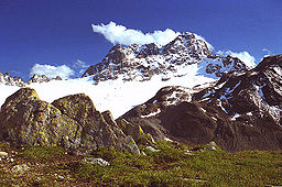
Piz Kesch or Piz d'Es-cha (Rumantsch) is a peak in the Albula Range
of the Rhaetian Alps
. At 3,418 m, it is the highest peak in the Albula Range and the municipality of Bergün
, Grisons.
The first ascent was made 1846 by J. Coaz, J. Rascher, C. Casper and J. Tscharner.
between the Rhine drainage basin
(North Sea
) and the Danube
drainage basin (Black Sea
). It is also the highest peak in the Eastern Alps north of the Inn River
. On the north side lies the Porchabella Glacier
.
 West of Piz Kesch lies the Albula pass (Pass d'Alvra in Rumantsch); to the north lies the valley of Davos
, and to the south lies the Upper Engadine. On the foot of Piz Kesch in the Engadine lies the village of Madulain
(1,694 m).
Two SAC's alpine huts lie close to Piz Kesch which are the Chamanna d'Es-Cha or Es-Cha Hütte (ca 2,594 m), and the Kesch-Hütte or Chamanna digl Kesch at (ca 2,625 m). The first lies on a 3-hour walk from Madulain
, La Punt and Zuoz
and about 1½ hour
s from the Albula pass road. Kesch-Hütte lies 4½ hours from Bergün
and can be reached as well from the Davos
southern valleys of Sertig
and Dischma
or by a longer walk via Val Susauna coming from Cinuos-chel.
and Fowler, with guides C. Michel and M. Payot. From the Platzli huts, located above Bergün
, they reached in 3 hours a pass (3,008 m) on the ridge above the Vadret da Porchabella, overlooking the head of the Es-cha valley on the east. From this — called Porta d'Es-cha — they finally reached the peak in less than 2 hours. They afterwards descended in 3 hours from the pass to La Punt on the east side of the mountain.
According to Tuckett, they were the first to reach the highest summit:
thus not accessible on hiking trails. The "Kesch-Trek" leads from Dischma via the Scaletta pass towards the southwest and to the Kesch-. In the following leg the route passes the western face and reaches Chamanna d'Es-Cha hut via Fuorcla Pischa, lying already in the southern face of Piz Kesch.
Albula Range
The Albula Alps is a mountain range in the Alps of eastern Switzerland. It is considered to be part of the Central Eastern Alps. It is named after the River Albula...
of the Rhaetian Alps
Rhaetian Alps
The Rhaetian Alps are a part of the Central Eastern Alps along the Italian–Swiss and Austrian–Swiss borders, mostly located in the Graubünden canton in eastern Switzerland.Piz Bernina , set on the Italian border, is the highest peak....
. At 3,418 m, it is the highest peak in the Albula Range and the municipality of Bergün
Bergün
Bergün/Bravuogn , is a municipality in the district of Albula in the canton of Graubünden in Switzerland. The double name has been the official name since 1943.-Geography:...
, Grisons.
The first ascent was made 1846 by J. Coaz, J. Rascher, C. Casper and J. Tscharner.
Geography
Piz Kesch is part of the mountain ridge which divides the southeastern Swiss AlpsSwiss Alps
The Swiss Alps are the portion of the Alps mountain range that lies within Switzerland. Because of their central position within the entire Alpine range, they are also known as the Central Alps....
between the Rhine drainage basin
Drainage basin
A drainage basin is an extent or an area of land where surface water from rain and melting snow or ice converges to a single point, usually the exit of the basin, where the waters join another waterbody, such as a river, lake, reservoir, estuary, wetland, sea, or ocean...
(North Sea
North Sea
In the southwest, beyond the Straits of Dover, the North Sea becomes the English Channel connecting to the Atlantic Ocean. In the east, it connects to the Baltic Sea via the Skagerrak and Kattegat, narrow straits that separate Denmark from Norway and Sweden respectively...
) and the Danube
Danube
The Danube is a river in the Central Europe and the Europe's second longest river after the Volga. It is classified as an international waterway....
drainage basin (Black Sea
Black Sea
The Black Sea is bounded by Europe, Anatolia and the Caucasus and is ultimately connected to the Atlantic Ocean via the Mediterranean and the Aegean seas and various straits. The Bosphorus strait connects it to the Sea of Marmara, and the strait of the Dardanelles connects that sea to the Aegean...
). It is also the highest peak in the Eastern Alps north of the Inn River
Inn River
The Inn is a river in Switzerland, Austria and Germany. It is a right tributary of the Danube and is approximately 500km long. The highest point of its drainage basin is the summit of Piz Bernina, at 4,049 metres.- Geography :...
. On the north side lies the Porchabella Glacier
Porchabella Glacier
The Porchabella Glacier is a 2 km long glacier situated in the Albula Range in the canton of Graubünden in Switzerland. In 1973 it had an area of 2.58 km²....
.
Davos
Davos is a municipality in the district of Prättigau/Davos in the canton of Graubünden, Switzerland. It has a permanent population of 11,248 . Davos is located on the Landwasser River, in the Swiss Alps, between the Plessur and Albula Range...
, and to the south lies the Upper Engadine. On the foot of Piz Kesch in the Engadine lies the village of Madulain
Madulain
Madulain is a municipality in the district of Maloja in the Swiss canton of Graubünden.-Geography:Madulain has an area, , of . Of this area, 33.9% is used for agricultural purposes, while 14.6% is forested...
(1,694 m).
Two SAC's alpine huts lie close to Piz Kesch which are the Chamanna d'Es-Cha or Es-Cha Hütte (ca 2,594 m), and the Kesch-Hütte or Chamanna digl Kesch at (ca 2,625 m). The first lies on a 3-hour walk from Madulain
Madulain
Madulain is a municipality in the district of Maloja in the Swiss canton of Graubünden.-Geography:Madulain has an area, , of . Of this area, 33.9% is used for agricultural purposes, while 14.6% is forested...
, La Punt and Zuoz
Zuoz
Zuoz is a municipality in the district of Maloja in the Swiss canton of Graubünden.-History:Zuoz is first mentioned about 840 as Zuzes. Historically, Zuoz was the political center of the upper Engadin. It was the seat of the local bishop. But, it has long ago been supplanted by other Engadin...
and about 1½ hour
Hour
The hour is a unit of measurement of time. In modern usage, an hour comprises 60 minutes, or 3,600 seconds...
s from the Albula pass road. Kesch-Hütte lies 4½ hours from Bergün
Bergün
Bergün/Bravuogn , is a municipality in the district of Albula in the canton of Graubünden in Switzerland. The double name has been the official name since 1943.-Geography:...
and can be reached as well from the Davos
Davos
Davos is a municipality in the district of Prättigau/Davos in the canton of Graubünden, Switzerland. It has a permanent population of 11,248 . Davos is located on the Landwasser River, in the Swiss Alps, between the Plessur and Albula Range...
southern valleys of Sertig
Sertig
The Sertig Valley is located in the municipality of Davos, south of the town, in the Swiss canton of Graubünden. It is a lateral valley of the Landwasser valley. The small village of Sertig Dörfli is accessible by road.-External links:*...
and Dischma
Dischma
The Dischma is a valley on the territory of the Swiss municipality of Davos. The name is derived from the . It is documented as decimata in the 12th century.- Location :...
or by a longer walk via Val Susauna coming from Cinuos-chel.
Climbing history
The tower-like peak of Piz Kesch was reached for the first time on September 7, 1846, by Chr. Casper, Johann Coaz, J. Rascher, J.R. Tscharner. In 1864 the ascent was repeated by Francis Fox TuckettFrancis Fox Tuckett
Francis Fox Tuckett FRGS was an English mountaineer. He was vice-president of the Alpine Club from 1866 to 1868, and a Fellow of the Royal Geographical Society.-Life and family:...
and Fowler, with guides C. Michel and M. Payot. From the Platzli huts, located above Bergün
Bergün
Bergün/Bravuogn , is a municipality in the district of Albula in the canton of Graubünden in Switzerland. The double name has been the official name since 1943.-Geography:...
, they reached in 3 hours a pass (3,008 m) on the ridge above the Vadret da Porchabella, overlooking the head of the Es-cha valley on the east. From this — called Porta d'Es-cha — they finally reached the peak in less than 2 hours. They afterwards descended in 3 hours from the pass to La Punt on the east side of the mountain.
According to Tuckett, they were the first to reach the highest summit:
- "...we reached the summit of Piz Kesch without the slightest difficulty in 1 hour 10 m. (45 m. over snow and 25 m. up very steep but good rocks). On a second summit to the SE., which a level showed to be slightly lower than where we stood, was planted a baton; but on our peak were no traces of any previous visit. M. Coaz, I was told, had ascended Piz Kesch a few years ago, so that probably he climbed the second peak by mistake."
Hiking
A network of marked mountain paths leads to the southern, western and northern face of Piz Kesch wereas the eastern face is covered with a glacier and connected with the rest of this massifMassif
In geology, a massif is a section of a planet's crust that is demarcated by faults or flexures. In the movement of the crust, a massif tends to retain its internal structure while being displaced as a whole...
thus not accessible on hiking trails. The "Kesch-Trek" leads from Dischma via the Scaletta pass towards the southwest and to the Kesch-. In the following leg the route passes the western face and reaches Chamanna d'Es-Cha hut via Fuorcla Pischa, lying already in the southern face of Piz Kesch.