
Pir Sohawa
Encyclopedia
Islamabad
Islamabad is the capital of Pakistan and the tenth largest city in the country. Located within the Islamabad Capital Territory , the population of the city has grown from 100,000 in 1951 to 1.7 million in 2011...
and is located close to Monal village which exists on the slope towards Islamabad city. Actually Pir Sohawa is a village located in district Haripur of Khyber Pakhtoonkhaw Province, formerly called North Western Frontier Province (NWFP) of Pakistan
Pakistan
Pakistan , officially the Islamic Republic of Pakistan is a sovereign state in South Asia. It has a coastline along the Arabian Sea and the Gulf of Oman in the south and is bordered by Afghanistan and Iran in the west, India in the east and China in the far northeast. In the north, Tajikistan...
. Due to unknown reason, the name of village Pir Sohawa replaced the name of this recreation spot instead of Monal.
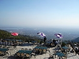
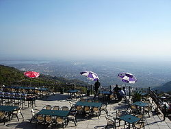
A restaurant named as "Monal Restaurant" is located at Pir Sohawa site. Monal Restaurant was completed in 2006. Its spaceous terraces provide a breathtaking view of Islamabad in clear day light and a stunningly beautiful show of the city lights at the bottom, after sunset. One can enjoy the breeze and fragrance, especially during summer's hot days, of thick forest present all around.
This is a unique point where one can compare the urban and rural Pakistan simply by turning the head from one side (looking at Islamabad) to other side (looking towards rear lush green valley with villages, flowing streams and mountains beyond).
Pir Sohawa attracts tourists in winter, as the elevation (+5000 ft) is sufficient for occasional snowfall. Its a popular place among the citizens of Islamabad, as well as the foreign visitors and tourists.
This place is connected to Islamabad by a road, on which is located Daman-e-Koh
Daman-e-Koh
Daman-e-Koh, about 3000ft from sea level and almost 1000ft higher than City of Islamabad, is a viewing point and hill top modern garden, popular among the residents as well as the visitors to this capital town of the nation....
, a fantastic forest-garden and a picnic point worth visiting. It is a destination point for a hiking trip from the bottom of Margalla Hills
Margalla Hills
The Margalla Hills—the foothills of the Himalayas—are a series of small-elevation hills located north of Islamabad, Pakistan. Margalla Range has an area of 12,605 hectares. The hill range nestles between an elevation of 685 meters at the western end and 1,604 meters on its east.- Etymology :Two...
climbing 3000 ft almost vertically straight up from the village of Saidpur, Islamabad
Islamabad
Islamabad is the capital of Pakistan and the tenth largest city in the country. Located within the Islamabad Capital Territory , the population of the city has grown from 100,000 in 1951 to 1.7 million in 2011...
.
Historically, when there were no roads available, Pir Sohawa top was a midway resting point for travellers of Hazara areas (north of Islamabad), ascending and descending the rear mountains and heading towards Rawalpindi, Pakistan
Pakistan
Pakistan , officially the Islamic Republic of Pakistan is a sovereign state in South Asia. It has a coastline along the Arabian Sea and the Gulf of Oman in the south and is bordered by Afghanistan and Iran in the west, India in the east and China in the far northeast. In the north, Tajikistan...
.