
Pine Island Glacier
Encyclopedia
Ice sheet drainage
Antarctic ice sheet
The Antarctic ice sheet is one of the two polar ice caps of the Earth. It covers about 98% of the Antarctic continent and is the largest single mass of ice on Earth. It covers an area of almost 14 million square km and contains 30 million cubic km of ice...
is the largest mass of ice on earth, containing a volume of water equivalent to 57 m (187 ft) of global sea level. The ice sheet forms from snow which falls onto the continent and compacts under its own weight. The ice then moves under its own weight toward the edges of the continent. Most of this transport to the sea is by ice streams (faster moving channels of ice surrounded by slower moving ice walls) and outlet glaciers. The Antarctic ice sheet consists of the large, relatively stable, East Antarctic Ice Sheet
East Antarctic Ice Sheet
The East Antarctic Ice Sheet is one of two large ice sheets in Antarctica, and the largest on the entire planet. The EAIS lies between 45° West and 168° East longitudinally....
and a smaller, less stable, West Antarctic Ice Sheet. The West Antarctic Ice Sheet is drained into the sea by several large ice streams, most of which flow into either the Ross Ice Shelf
Ross Ice Shelf
The Ross Ice Shelf is the largest ice shelf of Antarctica . It is several hundred metres thick. The nearly vertical ice front to the open sea is more than 600 km long, and between 15 and 50 metres high above the water surface...
, or the Filchner-Ronne Ice Shelf
Filchner-Ronne Ice Shelf
The Filchner-Ronne Ice Shelf, also known as Ronne-Filchner Ice Shelf, is an Antarctic ice shelf bordering the Weddell Sea.-Description:...
. Pine Island and Thwaites
Thwaites Glacier
Thwaites Glacier is an unusually broad and fast Antarctic glacier flowing into Pine Island Bay, part of the Amundsen Sea, east of Mount Murphy, on the Walgreen Coast of Marie Byrd Land. Its surface speeds exceed 2 km/yr near its grounding line, and its fastest flowing grounded ice is centred...
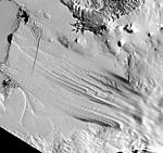
Glaciers are two major West Antarctic ice streams which do not flow into a large ice shelf. They are part of an area called the Amundsen Sea Embayment. A total area of 175000 km² (67,567.9 sq mi), 10 percent of the West Antarctic Ice Sheet, drains out to the sea via Pine Island Glacier, this area is known as the Pine Island Glacier drainage basin.
Weak underbelly of the West Antarctic Ice Sheet
The Pine Island and ThwaitesThwaites Glacier
Thwaites Glacier is an unusually broad and fast Antarctic glacier flowing into Pine Island Bay, part of the Amundsen Sea, east of Mount Murphy, on the Walgreen Coast of Marie Byrd Land. Its surface speeds exceed 2 km/yr near its grounding line, and its fastest flowing grounded ice is centred...
Glaciers are two of Antarctica's five largest ice stream
Ice stream
An ice stream is a region of an ice sheet that moves significantly faster than the surrounding ice. Ice streams are a type of glacier. They are significant features of the Antarctic where they account for 10% of the volume of the ice...
s. Scientists have found that the flow of these ice streams has accelerated in recent years, and suggested that if they were to melt, global sea levels would rise by 0.9 metre, destabilising the entire West Antarctic Ice Sheet
West Antarctic Ice Sheet
The West Antarctic Ice Sheet is the segment of the continental ice sheet that covers West Antarctica, the portion of Antarctica on the side of the Transantarctic Mountains which lies in the Western Hemisphere. The WAIS is classified as a marine-based ice sheet, meaning that its bed lies well...
and perhaps sections of the East Antarctic Ice Sheet
East Antarctic Ice Sheet
The East Antarctic Ice Sheet is one of two large ice sheets in Antarctica, and the largest on the entire planet. The EAIS lies between 45° West and 168° East longitudinally....
.
In 1981 Terry Hughes proposed that the region around Pine Island Bay may be a "weak underbelly" of the West Antarctic Ice Sheet. This is based on the fact that, unlike the majority of the large West Antarctic ice streams, those flowing into the Amundsen Sea
Amundsen Sea
The Amundsen Sea is an arm of the Southern Ocean off Marie Byrd Land in western Antarctica. It is bounded by Cape Flying Fish, the northwestern tip of Thurston Island to the east and Cape Dart on Siple Island to the west. East of Cape Flying Fish starts the Bellingshausen Sea. West of Cape Dart is...
are not protected from the ocean by large floating ice shelves
Ice shelf
An ice shelf is a thick, floating platform of ice that forms where a glacier or ice sheet flows down to a coastline and onto the ocean surface. Ice shelves are only found in Antarctica, Greenland and Canada. The boundary between the floating ice shelf and the grounded ice that feeds it is called...
. Also, although the surface of the glacier is above sea level, the base lies below sea level and slopes downward inland, this suggests that there is no geological barrier to stop a retreat of the ice once it has started.
Acceleration and thinning
The speed of Pine Island Glacier increased by 73 percent from 1974 to the end of 2007, with an 8 percent increase over the last 16 months of this period alone. This speed up has meant that by the end of 2007 the Pine Island Glacier system had a negative mass balanceGlacier mass balance
Crucial to the survival of a glacier is its mass balance, the difference between accumulation and ablation . Climate change may cause variations in both temperature and snowfall, causing changes in mass balance. Changes in mass balance control a glacier's long term behavior and is the most...
of 46 gigatonnes per year, which is equivalent to 0.13 mm (0.00511811023622047 in) per year global sea level rise
Current sea level rise
Current sea level rise potentially impacts human populations and the wider natural environment . Global average sea level rose at an average rate of around 1.8 mm per year over 1961 to 2003 and at an average rate of about 3.1 mm per year from 1993 to 2003...
. In other words, much more water was being put into the sea by PIG than was being replaced by snowfall. Measurements along the centre of the ice stream by GPS
Global Positioning System
The Global Positioning System is a space-based global navigation satellite system that provides location and time information in all weather, anywhere on or near the Earth, where there is an unobstructed line of sight to four or more GPS satellites...
demonstrated that this acceleration is still high nearly 200 km (124.3 mi) inland, at around 4 percent over 2007. It has been suggested that this recent acceleration could have been triggered by warm ocean waters at the end of PIG, where it has a floating section (ice shelf
Ice shelf
An ice shelf is a thick, floating platform of ice that forms where a glacier or ice sheet flows down to a coastline and onto the ocean surface. Ice shelves are only found in Antarctica, Greenland and Canada. The boundary between the floating ice shelf and the grounded ice that feeds it is called...
) approximately 50 km (31.1 mi) long.
As the ice stream accelerates it is also getting steeper. The rate of thinning within the central trunk has quadrupled from 1995 to 2006. If the current rate of acceleration were to continue the main trunk of the glacier could be afloat within 100 years.
Subglacial volcano
In January 2008 the British Antarctic SurveyBritish Antarctic Survey
The British Antarctic Survey is the United Kingdom's national Antarctic operation and has an active role in Antarctic affairs. BAS is part of the Natural Environment Research Council and has over 400 staff. It operates five research stations, two ships and five aircraft in and around Antarctica....
(BAS) scientists, Hugh Corr and David Vaughan, reported that 2,200 years ago a volcano
Volcano
2. Bedrock3. Conduit 4. Base5. Sill6. Dike7. Layers of ash emitted by the volcano8. Flank| 9. Layers of lava emitted by the volcano10. Throat11. Parasitic cone12. Lava flow13. Vent14. Crater15...
erupted under the Antarctic ice sheet
Antarctic ice sheet
The Antarctic ice sheet is one of the two polar ice caps of the Earth. It covers about 98% of the Antarctic continent and is the largest single mass of ice on Earth. It covers an area of almost 14 million square km and contains 30 million cubic km of ice...
. This was the biggest Antarctic eruption in the last 10,000 years. The volcano is situated in the Hudson Mountains
Hudson Mountains
The Hudson Mountains is a group of parasitic cones forming nunataks just above the Antarctic ice sheet in west Ellsworth Land. They lie just east of Cranton Bay and Pine Island Bay at the eastern extremity of Amundsen Sea, and are bounded on the north by Cosgrove Ice Shelf and on the south by Pine...
, close to Pine Island Glacier. The eruption spread a layer of volcanic ash
Volcanic ash
Volcanic ash consists of small tephra, which are bits of pulverized rock and glass created by volcanic eruptions, less than in diameter. There are three mechanisms of volcanic ash formation: gas release under decompression causing magmatic eruptions; thermal contraction from chilling on contact...
(or tephra
Tephra
200px|thumb|right|Tephra horizons in south-central [[Iceland]]. The thick and light coloured layer at center of the photo is [[rhyolitic]] tephra from [[Hekla]]....
) over the surface of the ice sheet. This ash was then buried under the snow and ice. Corr and Vaughan were able to map this ash layer using an airborne radar system and calculate the date of the eruption from the depth of burial of the ash. This method uses dates calculated from nearby ice core
Ice core
An ice core is a core sample that is typically removed from an ice sheet, most commonly from the polar ice caps of Antarctica, Greenland or from high mountain glaciers elsewhere. As the ice forms from the incremental build up of annual layers of snow, lower layers are older than upper, and an ice...
s. The presence of the volcano raises the possibility that volcanic activity could have contributed, or may contribute in the future, to increases in the flow of the glacier.
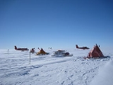
On the ice
The first expedition to visit the ice stream was a United States over-snow traverse, where they spent around a week in the area of PIG during January 1961. They dug snow pits to measure snow accumulation and carried out seismic surveys to measure ice thickness. One of the scientists on this traverse was Charles R. Bentley, who claims "we didn't know we were crossing a glacier at the time." This is not surprising, because PIG is around 50 km (31.1 mi) wide at the point visited and at ground level cannot be visually distinguished from the surrounding ice. This expedition was called the Ellsworth Highland Traverse.
Then in the 2004/2005 field season a team of 9 using a British Antarctic Survey (BAS) Twin Otter aircraft, equipped with ice penetrating radar, completed an aerial survey of PIG and its adjacent ice sheet. The team of 7 British & 2 Americans led by Dave Vaughan & Hugh Corr flew 30km grid patterns over the PIG until mid-January 05, mapping the sub-glacial terrain of that area roughly equal to the size of the State of Nevada.
Due to the remoteness of PIG and the logistical difficulties of caching enough fuel for the 04/05 expedition and future project(s), BAS used the resources of the United States Antarctic Program (USAP) and their ski-equipped C130 aircraft.
After many weeks of weather delays the first four men (Ben Partan, Rob Smith, Dave Anderson & Martin Bell) arrived from McMurdo
McMurdo Station
McMurdo Station is a U.S. Antarctic research center located on the southern tip of Ross Island, which is in the New Zealand-claimed Ross Dependency on the shore of McMurdo Sound in Antarctica. It is operated by the United States through the United States Antarctic Program, a branch of the National...
on 11/9/04 and began to establish camp and build a skiway for the C130’s. Camp was established on the upper end of the ice stream at S77.76973 x W095.12713. The remaining members of the team arrived from Rothera
Rothera Research Station
Rothera research station is a British Antarctic Survey base on the Antarctic Peninsula, located at Rothera Point, Adelaide Island. Rothera also serves as the capital of the British Overseas Territory, the British Antarctic Territory....
approximately 10 days later in the Twin Otter, flown by survey pilot Dave Leatherdale.
Because of unusually good weather in the area that season the survey completed flying their grids early (mid-January) and began flying 15km grids of Thwaites Glacier
Thwaites Glacier
Thwaites Glacier is an unusually broad and fast Antarctic glacier flowing into Pine Island Bay, part of the Amundsen Sea, east of Mount Murphy, on the Walgreen Coast of Marie Byrd Land. Its surface speeds exceed 2 km/yr near its grounding line, and its fastest flowing grounded ice is centred...
for a USAP expedition who had been experiencing unusually poor weather in their area that year.
All survey grids having been completed by the end of January, the survey crew flew back to Rothera
Rothera Research Station
Rothera research station is a British Antarctic Survey base on the Antarctic Peninsula, located at Rothera Point, Adelaide Island. Rothera also serves as the capital of the British Overseas Territory, the British Antarctic Territory....
leaving the two Americans and two British to dismantle the camp. A week later the remaining team members flew back to McMurdo
McMurdo Station
McMurdo Station is a U.S. Antarctic research center located on the southern tip of Ross Island, which is in the New Zealand-claimed Ross Dependency on the shore of McMurdo Sound in Antarctica. It is operated by the United States through the United States Antarctic Program, a branch of the National...
leaving a fuel cache for future expeditions.
Another team from the British Antarctic Survey
British Antarctic Survey
The British Antarctic Survey is the United Kingdom's national Antarctic operation and has an active role in Antarctic affairs. BAS is part of the Natural Environment Research Council and has over 400 staff. It operates five research stations, two ships and five aircraft in and around Antarctica....
arrived at the ice stream on 8 December 2006 for the first of two field seasons. In the second field season, they spent three months there from November 2007 to February 2008. Work on the glacier included radar
Ground-penetrating radar
Ground-penetrating radar is a geophysical method that uses radar pulses to image the subsurface. This nondestructive method uses electromagnetic radiation in the microwave band of the radio spectrum, and detects the reflected signals from subsurface structures...
measurements and seismic surveys
Reflection seismology
Reflection seismology is a method of exploration geophysics that uses the principles of seismology to estimate the properties of the Earth's subsurface from reflected seismic waves. The method requires a controlled seismic source of energy, such as dynamite/Tovex, a specialized air gun or a...
.
In January 2008 Bob Bindschadler
Robert Bindschadler
Dr. Robert Bindschadler is a senior fellow at NASA's Goddard Space Flight Center and has been an active field researcher in the Antarctic for over 25 years...
(NASA
NASA
The National Aeronautics and Space Administration is the agency of the United States government that is responsible for the nation's civilian space program and for aeronautics and aerospace research...
) landed on the floating ice shelf
Ice shelf
An ice shelf is a thick, floating platform of ice that forms where a glacier or ice sheet flows down to a coastline and onto the ocean surface. Ice shelves are only found in Antarctica, Greenland and Canada. The boundary between the floating ice shelf and the grounded ice that feeds it is called...
of PIG, this is at the downstream end where it floats on the sea. This landing, by a Twin Otter plane fitted with skis, was the first ever landing on this ice shelf. The reason for landing on the ice shelf was for a reconnaissance mission to investigate the feasibility of drilling through around 500 m (1,640.4 ft) of ice, to lower instruments into the ocean cavity below. It is hoped that this will provide important information on the link between the ocean and Pine Island Glacier. It was decided that the small crevasse
Crevasse
A crevasse is a deep crack in an ice sheet rhys glacier . Crevasses form as a result of the movement and resulting stress associated with the sheer stress generated when two semi-rigid pieces above a plastic substrate have different rates of movement...
free area was too hard for further landings and so further fieldwork had to be postponed. Therefore two GPS
Global Positioning System
The Global Positioning System is a space-based global navigation satellite system that provides location and time information in all weather, anywhere on or near the Earth, where there is an unobstructed line of sight to four or more GPS satellites...
units and a weather station were positioned as near as possible to PIG.
Since then, the National Science Foundation
National Science Foundation
The National Science Foundation is a United States government agency that supports fundamental research and education in all the non-medical fields of science and engineering. Its medical counterpart is the National Institutes of Health...
has decided to establish a helicopter camp for the scientists to safely study the ice-ocean interaction. During the 2010–11 summer field season in Antarctica, it is planned that tractors and sleds will haul all of the equipment needed to establish a camp near the ice shelf. A tractor train traverse of about 700 km (435 mi) is needed to deliver the materials. The plan over the following two field seasons, 2011–12 and 2012–13, is for scientists to use helicopters to fly to sites on the ice shelf, where they will deploy specially designed profilers down through the ice shelf to measure various ocean properties.
From the sea
The first ship to reach Pine Island Glacier's ice shelf, in Pine Island Bay, was the USS/USCGC GlacierUSS Glacier (AGB-4)
USS Glacier is the historic Glacier class icebreaker which served in the first through fifteenth Operation Deep Freeze expeditions. Glacier was first icebreaker to make her way through the frozen Bellingshausen Sea, and most of the topography in the area is named for her crewmembers...
in 1985. This ship was an icebreaker operated by the U.S. Coast Guard. The mission, known as Deep Freeze, had scientists on board who took sediment samples from the ocean floor.
During the summer field season, over two months from January to February 2009, researchers aboard the U.S. Antarctic Program research vessel Nathaniel B. Palmer
Nathaniel B. Palmer (icebreaker)
The Nathaniel B. Palmer is an ice-capable research ship in the service of the U.S. National Science Foundation. It is tasked with extended scientific missions in the Antarctic....
reached the ice shelf. This was the second time that the Palmer had successfully made it up to the glacier, the first time being in 1994. In collaboration with the British, the scientists used a robotic submarine to explore the glacier-carved channels on the continental shelf as well as the cavity below the ice shelf and glacier. The submarine, known as Autosub 3, was developed and built at the National Oceanography Centre
National Oceanography Centre
- The National Oceanography Centre :The National Oceanography Centre is a marine science research and technology institution based on two sites in Southampton and Liverpool, United Kingdom...
in the UK. It completed six successful missions, travelling a total of 500 km (310.7 mi) under the ice shelf. Autosub is able to map the base of the ice shelf as well as the ocean floor and take various measurements and samples of the water on the way. The success of Autosub 3 was particularly notable because its predecessor Autosub 2 was lost beneath the Fimbul Ice Shelf
Fimbul Ice Shelf
Fimbul Ice Shelf is an ice shelf about 120 miles long and 60 miles wide, nourished by Jutulstraumen Glacier, bordering the coast of Queen Maud Land from 3° W to 3° E...
on only its second such mission.
See also
External links
- Geo-temporal-spatial map of research publications on PIG and surrounding area
- NASA Earth Observatory: Images of Pine Island Glacier
- NASA Earth Observatory: Channel Beneath Pine Island Glacier